Get Premium
Dark mode theme is available exclusively for premium users. Learn more about the benefits of subscribing.
No fees, cancel anytime.

 Dark Mode Ad-Free Browsing Unlimited Content
 Ad-Free Browsing Unlimited Content Dark Mode
Join 1.2 million Panda readers who get the best art, memes, and fun stories every week!
28submissions
Finished
If an atlas was your favorite ‘book’ as a child and spending time on Google Maps is now a favored pastime, welcome to the best post you’ll see all day. While it is a bold statement to make, any fan of maps ought to love today’s list, as it’s dedicated to all sorts of old and ancient maps.
So, without further ado, scroll down to find some of the most unique examples of cartography that we managed to find on the internet, and enjoy the trip they take you on. While you’re at it, make sure to upvote your favorite maps, too!
Below you will also find Bored Panda’s interview with assistant professor of geography at University of Oregon, an expert in cartography, map design, and mapping environment-society interactions, Carolyn Fish, who was kind enough to answer a few of our questions.
This post may include affiliate links.
Ptolemy's world map designed in 150 AD. For the first time in history, longitudinal and latitudinal lines were added to a world map.
Samuel Dunn's map of the world, drawn in 1794 AD. Dunn was the first to map out the entire world using Captain James Cook's discoveries as his guide.
The Psalter World Map, drawn by an unknown medieval monk in 1260 AD. Maps from this time period usually place the east at the top of the globe, where the sun rises and Jesus watches over the world.
Roman Empire became the most dominant country globally by AD 98–117 through a mixture of military power, political adaptability, and economic enlargement. This enlargement drastically transformed the Mediterranean world.
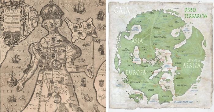
The Bunting Clover Leaf Map, created by Heinrich Bunting in Germany in 1581, is a later Christian map. This map represents the world as an extension of the Christian trinity, with Jerusalem serving as the hub that binds it all together, rather than how it actually is.
World map by Cosmas Indicopleustes from the sixth century, which shows the globe as a rectangular-shaped surface.


 No fees, cancel anytime


")
")


