ADVERTISEMENT

Are you a fan of cartography but curious to see the world through a different lens? Have you ever wondered how many blue whales would fit into the Vatican? Or what would the ancient continent of Pangea would look like with modern political borders? Or maybe you just would like to see how Manhattan looked while it was still called New Amsterdam?

If you've said "yes" to at least one of these, you're in luck! Bored Panda has prepared a compilation of cool maps from the Vintage Maps page on X where you can learn history and interesting new facts through the medium of cartography. So, scroll through these maps and marvel at how cool our world is.

More info: X (Twitter)

#1

Map of Australia showing population density with highlighted urban areas for a cool map from cartography enthusiasts collection.

vintagemapstore Report

Manic Mama
Community Member
2 hours ago Created by potrace 1.15, written by Peter Selinger 2001-2017

I grew up right in the centre, and I can tell you there's a very good reason why all the people live where they do.

GenuineJen
Community Member
2 hours ago (edited) Created by potrace 1.15, written by Peter Selinger 2001-2017

All of Australia lives there.

Huddo's sister
Community Member
5 minutes ago Created by potrace 1.15, written by Peter Selinger 2001-2017

I used to live in one of the blue areas, but now I'm an hour and a half to the east of thet.

RELATED:
    #4

    Map showing the Roman Empire and the Mongol Empire at their peaks highlighting historical boundaries in a cool maps style.

    vintagemapstore Report

    Robert Trebor
    Community Member
    2 hours ago Created by potrace 1.15, written by Peter Selinger 2001-2017

    Looks like a reclining blue dragon nibbling on the Balkans.

    Auntriarch
    Community Member
    43 minutes ago Created by potrace 1.15, written by Peter Selinger 2001-2017

    If you want a dragon nibbling your Balkans, that's entirely up to you

    Load More Replies...
    ADVERTISEMENT
    ADVERTISEMENT
    #7

    Map showing locations of cities founded by the Roman Empire outside Italy with red dots on a Europe map, cool maps collection.

    vintagemapstore Report

    Kira Okah
    Community Member
    3 hours ago Created by potrace 1.15, written by Peter Selinger 2001-2017

    I'm trying to work out exactly what one that is in SW Wales. Is that Moridunum perhaps? Modern name Caerfyrddin/Carmarthen. A LOT of historians do like to claim that Romans never went that far west in Wales, in spite of the clear evidence in Carmarthen itself. Random map on the internet possibly being more accurate than quite a number of Roman Britain historians.

    Sian E
    Community Member
    3 hours ago (edited) Created by potrace 1.15, written by Peter Selinger 2001-2017

    Yes that's Carmarthen. I should know, it's where I am right now! Also, which historians? I wanna go slap them with a bunch of Roman artefacts from the museum!

    Load More Replies...
    ADVERTISEMENT
    ADVERTISEMENT
    #10

    Map comparing the size of the Vatican state to a blue whale for cool maps that engage non-cartography enthusiasts.

    vintagemapstore Report

    Auntriarch
    Community Member
    40 minutes ago Created by potrace 1.15, written by Peter Selinger 2001-2017

    I suppose you wouldn't see a banana against all that yellow

    #11

    World map highlighting cradles of civilization with key regions noted in a vintage style cool map for cartography enthusiasts.

    vintagemapstore Report

    Stardust she/her
    Community Member
    Premium
    2 hours ago Created by potrace 1.15, written by Peter Selinger 2001-2017

    Something I love is how every culture has at some point had a mythological story about a great flood as it shows how our cultures have originated near rivers and experienced major. river flooding at some point

    ADVERTISEMENT
    #13

    Map comparing the sizes of dwarf planets Ceres and Pluto to Texas and the Moon on a US geographic background.

    vintagemapstore Report

    Stardust she/her
    Community Member
    Premium
    2 hours ago Created by potrace 1.15, written by Peter Selinger 2001-2017

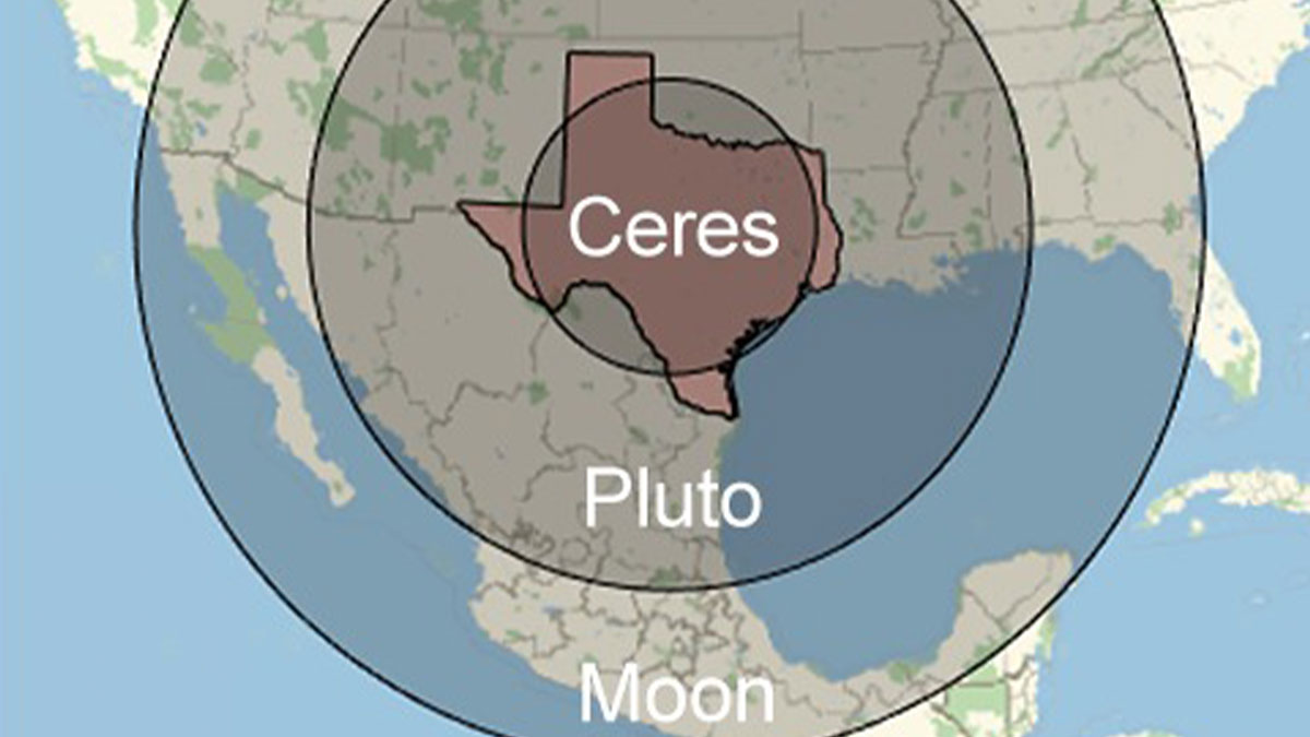
    I will never shut up about how Pluto gets more attention than all the other dwarf planets just because it’s the only one you remember. The other dwarf planets are equally as interesting with interesting histories as well. Did you know that at one point Ceres was demoted from a planet to an asteroid and then to a dwarf planet? Did anyone complain back then about their favourite planet Ceres becoming an asteroid?

    Multa Nocte
    Community Member
    Premium
    29 minutes ago Created by potrace 1.15, written by Peter Selinger 2001-2017

    Stardust, you don't understand the relationship that a lot of us old timers have with Pluto. When we were in school we were taught that Pluto was a planet, the farthest one out, and we all kept an eye out for it, being so far away and so small. We had to learn its name and its position and some of us even had to learn little songs and rhymes about it being one of the planets. None of us had to learn about Ceres so we have no emotional attachment. You are young. One day, when you get older, when they take something that has been part of the fundamentals of your life and throw it away, you will see why we want to keep our little familiar buddy Pluto. Pluto - we love you and we believe you should still be a planet! 💔

    Load More Replies...
    ADVERTISEMENT
    #15

    Ancient map of the Earth by Hecataeus of Miletus showcasing early cartography in a circular design.

    vintagemapstore Report

    Roman Arendt
    Community Member
    43 minutes ago Created by potrace 1.15, written by Peter Selinger 2001-2017

    Africa had to wait about 300 years to get that name.

    Load More Replies...
    ADVERTISEMENT
    #17

    Oceans centered world map highlighting continents and oceans in a unique cartography style for map enthusiasts.

    vintagemapstore Report

    GenuineJen
    Community Member
    2 hours ago (edited) Created by potrace 1.15, written by Peter Selinger 2001-2017

    It always takes me a while to get my Bering(s) with this map. It's difficult to sea strait.

    Stardust she/her
    Community Member
    Premium
    2 hours ago Created by potrace 1.15, written by Peter Selinger 2001-2017

    Highly recommend all fish have at least one copy of this map, would be very useful for navigation

    ADVERTISEMENT
    #18

    Map of Europe illustrated with national animals, showcasing a creative and cool map concept for cartography enthusiasts.

    vintagemapstore Report

    GenuineJen
    Community Member
    2 hours ago Created by potrace 1.15, written by Peter Selinger 2001-2017

    It doesn't get better than the unicorn. Bless Scotland.

    #20

    Antique 1870s cashmere shawl featuring a detailed map of Kashmir with intricate patterns and landmarks.

    vintagemapstore Report

    Stardust she/her
    Community Member
    Premium
    1 hour ago Created by potrace 1.15, written by Peter Selinger 2001-2017

    Kashmir is such a beautiful place but it’s honestly a shame that the situation is such that it’s unsafe to visit

    ADVERTISEMENT
    #21

    Map showing early human migration routes with color-coded arrows on a historical world map, a cool map for cartography fans.

    vintagemapstore Report

    Stardust she/her
    Community Member
    Premium
    1 hour ago Created by potrace 1.15, written by Peter Selinger 2001-2017

    I often think about those people who migrated across Oceania. Those islands would’ve been very small and spread so far apart yet humans were able to somehow do it. I wonder how many of them didn’t make it, sailing across vast distances can be pretty hard especially with wooden rafts yet somehow just enough of us did

    Unicorn
    Community Member
    1 hour ago Created by potrace 1.15, written by Peter Selinger 2001-2017

    Sea level was much lower during the ice ages.

    Load More Replies...
    ADVERTISEMENT
    #22

    World map constructed from various local coins representing currency in a cool maps collection for cartography enthusiasts.

    vintagemapstore Report

    Stardust she/her
    Community Member
    Premium
    1 hour ago Created by potrace 1.15, written by Peter Selinger 2001-2017

    Living in India I don’t recognise a lot of the coins, maybe only the ₹5 coin but the rest are probably ancient

    Multa Nocte
    Community Member
    Premium
    21 minutes ago Created by potrace 1.15, written by Peter Selinger 2001-2017

    The ones for the US are current and it looks to be the case for much of Europe as well.

    Load More Replies...
    #23

    Map comparing the size of Brazil to the dwarf planet Pluto featured in cool maps for non-cartography enthusiasts.

    vintagemapstore Report

    Robert Trebor
    Community Member
    2 hours ago Created by potrace 1.15, written by Peter Selinger 2001-2017

    I'm glad poor Pluto is getting better recognition.

    Multa Nocte
    Community Member
    Premium
    20 minutes ago Created by potrace 1.15, written by Peter Selinger 2001-2017

    All us older folks are sad about our poor Pluto. :-(

    Load More Replies...
    ADVERTISEMENT
    #25

    Map showing the average color of each US state using satellite imagery, featured in cool maps for cartography enthusiasts.

    vintagemapstore Report

    Ian Webling
    Community Member
    18 minutes ago Created by potrace 1.15, written by Peter Selinger 2001-2017

    Surely Alaska should be white?

    ƒιѕн
    Community Member
    3 hours ago Created by potrace 1.15, written by Peter Selinger 2001-2017

    Wondering what time of year this data was collected.

    GenuineJen
    Community Member
    2 hours ago Created by potrace 1.15, written by Peter Selinger 2001-2017

    Technically there are enough pines in the eastern U.S. that it would be green (-ish) even in the winter.

    Load More Replies...
    ADVERTISEMENT
    #27

    US map showing states with more prisons than colleges in orange and more colleges than prisons in purple, cool maps chart.

    vintagemapstore Report

    Multa Nocte
    Community Member
    Premium
    3 hours ago Created by potrace 1.15, written by Peter Selinger 2001-2017

    Well, THERE'S a shocker! ;-)

    ƒιѕн
    Community Member
    3 hours ago (edited) Created by potrace 1.15, written by Peter Selinger 2001-2017

    Wrong. My state shouldn't be orange as it has 12 prisons including federal, and 25 colleges that you can earn bachelors or above. ETA, ok since it's including county jails then yes, we have 97 county jails.

    ADVERTISEMENT
    ADVERTISEMENT
    #30

    US map showing state borders following natural features like rivers and mountains in a cool map style.

    vintagemapstore Report

    nottheactualphoto
    Community Member
    3 hours ago Created by potrace 1.15, written by Peter Selinger 2001-2017

    Connecticut River: "What am I, chopped liver?"

    #31

    Ancient Earth world map showing continents and oceans around 19,000 B.C. for cool maps and cartography enthusiasts.

    vintagemapstore Report

    ƒιѕн
    Community Member
    3 hours ago Created by potrace 1.15, written by Peter Selinger 2001-2017

    We can get great satellite pics from 19000 BC but can't get a good bigfoot pic in 2026

    #32

    3D US elevation map showcasing terrain height variations, perfect for fans of cool maps and cartography enthusiasts.

    vintagemapstore Report

    ƒιѕн
    Community Member
    3 hours ago Created by potrace 1.15, written by Peter Selinger 2001-2017

    The Ozarks look like a tiny little bump out there all alone.

    ADVERTISEMENT
    #33

    Black and white vintage map of Africa showing borders defined by ethnicity and language for cool maps and cartography fans.

    vintagemapstore Report

    Multa Nocte
    Community Member
    Premium
    3 hours ago Created by potrace 1.15, written by Peter Selinger 2001-2017

    WOW! That's incredible!

    Roman Arendt
    Community Member
    31 minutes ago Created by potrace 1.15, written by Peter Selinger 2001-2017

    Yes. And incredibly sad what we Europeans made out of it. 😞

    Load More Replies...
    Jihana
    Community Member
    1 hour ago Created by potrace 1.15, written by Peter Selinger 2001-2017

    Took me a while to learn all 54 of the current countries. I'm not learning that map!

    ADVERTISEMENT
    See Also on Bored Panda
    #35

    Map showing all territories of the United States outlined across the Pacific Ocean in a cool maps collection

    vintagemapstore Report

    Multa Nocte
    Community Member
    Premium
    3 hours ago Created by potrace 1.15, written by Peter Selinger 2001-2017

    Someone better remind the orange Oompa-Loompa that Bad Bunny is actually an American.

    Did I say that out loud?
    Community Member
    3 hours ago Created by potrace 1.15, written by Peter Selinger 2001-2017

    I'm sure he knows, but Bad Bunny is the wrong colour of American.

    Load More Replies...
    #36

    Map showing the Mississippi River and its tributaries across the central United States, a cool map for cartography fans.

    vintagemapstore Report

    ƒιѕн
    Community Member
    3 hours ago Created by potrace 1.15, written by Peter Selinger 2001-2017

    100 bucks to any one that can name them all without cheating.

    SkyBlueandBlack
    Community Member
    3 hours ago Created by potrace 1.15, written by Peter Selinger 2001-2017

    I can pick out the Missouri and the Platte, both North and South. Good enough?

    Load More Replies...
    ADVERTISEMENT
    See Also on Bored Panda
    ADVERTISEMENT
    See Also on Bored Panda
    #38

    Map showing estimated number of words that derive from Arabic in various European languages, highlighting linguistic influence.

    vintagemapstore Report

    Unicorn
    Community Member
    57 minutes ago Created by potrace 1.15, written by Peter Selinger 2001-2017

    The Moors left their legacy in Spain.

    ADVERTISEMENT
    See Also on Bored Panda
    #41

    Map showing Bigfoot sightings across the US with data points highlighted, featured in cool maps for cartography enthusiasts.

    vintagemapstore Report

    ƒιѕн
    Community Member
    3 hours ago Created by potrace 1.15, written by Peter Selinger 2001-2017

    And not a single clear picture of said Bigfoot exists.

    Khavrinen
    Community Member
    3 hours ago Created by potrace 1.15, written by Peter Selinger 2001-2017

    Of course not. It's not like people are just carrying around a camera in their pocket all the time, or something...

    Load More Replies...
    ADVERTISEMENT
    See Also on Bored Panda
    ADVERTISEMENT
    See Also on Bored Panda
    #44

    Vintage map of the Old World from 1517 showing historical empires and regions in green on a blue background.

    vintagemapstore Report

    Kira Okah
    Community Member
    3 hours ago (edited) Created by potrace 1.15, written by Peter Selinger 2001-2017

    The area to the north of Joseon and east of Northern Yuan was the Jianzhou Jurchen Confederation. About 50 years after this map, the Ming tried to destabilise the Confederation, taking the grandson of one of the Jurchen chieftains (Giocangga) hostage and allying with another chieftain (Nikan Wailan). That hostage grandson was a boy named Nurhaci, who would go on to become the chieftain of the Jianzhou Confederacies, united the Jurchen under the name of "Manju" (anglicised: Manchu, believed to be an older name for the Jurchen) and under his banner of the Later Jin (renamed Daicing Gurun/Great Qing by his son and successor Hong Taiji, the Qing Dynasty you might know it as). They would become part of the fall of the Ming, and I find the lack of presence of the Jianzhou Jurchen Confederation annoying for how important they are to history, especially since the Four Oirat/Oirat Confederation is on here (so it is including important Asian continent Confederations).

    Multa Nocte
    Community Member
    Premium
    7 minutes ago Created by potrace 1.15, written by Peter Selinger 2001-2017

    Fabulous information - thanks!

    Load More Replies...
    Lost Panda
    Community Member
    3 hours ago Created by potrace 1.15, written by Peter Selinger 2001-2017

    Japan was never referred to as "Sengoku Jidai"... That was an era "Country at war era" you know line the "Victorian Era"

    #45

    Map displaying the genders of France’s rivers using colorful lines on a dark background, highlighting cool maps for cartography fans.

    vintagemapstore Report

    Multa Nocte
    Community Member
    Premium
    3 hours ago Created by potrace 1.15, written by Peter Selinger 2001-2017

    This is true. On a larger scale I live between *LA* Dordogne and *LA* Garonne, but the little river running through our local area is *LE* Dropt (it is a right tributary to the Garonne). It becomes second nature after a while, which is rather strange.

    Roman Arendt
    Community Member
    18 minutes ago (edited) Created by potrace 1.15, written by Peter Selinger 2001-2017

    Additionaly, in Germany we have neutral names for some small creeks (if the name is a permanent diminutive). Very rare though.

    Load More Replies...
    SkyBlueandBlack
    Community Member
    3 hours ago Created by potrace 1.15, written by Peter Selinger 2001-2017

    Rivers were male to the Romans, female to the Celts.

    Unicorn
    Community Member
    1 hour ago Created by potrace 1.15, written by Peter Selinger 2001-2017

    Could explain why no German rivers are neuter.

    Load More Replies...
    ADVERTISEMENT
    See Also on Bored Panda
    ADVERTISEMENT
    #47

    Map showing uneven distribution of population and wealth worldwide, highlighting key regions in a cool cartography style.

    vintagemapstore Report

    Multa Nocte
    Community Member
    Premium
    3 hours ago Created by potrace 1.15, written by Peter Selinger 2001-2017

    Hey New Zealand! You are finally on the map!

    #48

    Climate comparison map of North America and Eurasia highlighting temperature zones with country labels and color codes.

    vintagemapstore Report

    Stardust she/her
    Community Member
    Premium
    1 hour ago Created by potrace 1.15, written by Peter Selinger 2001-2017

    India and I think to an extent China have huge variations in climate across the country. What I know about India is that while it may be snowing in Kashmir, you could be boiling to death in South India while North-East India enjoys heavy rains

    ADVERTISEMENT
    #50

    Colorful geological map of North America showing detailed terrain features and elevations for map enthusiasts.

    vintagemapstore Report

    ƒιѕн
    Community Member
    3 hours ago Created by potrace 1.15, written by Peter Selinger 2001-2017

    Why does everything west of the divide look like Mordor

    Scarlett O'Hara's Ghost
    Community Member
    2 hours ago Created by potrace 1.15, written by Peter Selinger 2001-2017

    Because the the American desert southwest has the world's highest temps, consistently. Welcome to he!!

    Load More Replies...
    ADVERTISEMENT
    #53

    Vintage map showing Thomas Jefferson’s proposed division of western U.S. territory into states in 1784, a cool map for cartography fans.

    vintagemapstore Report

    Min
    Community Member
    Premium
    2 hours ago Created by potrace 1.15, written by Peter Selinger 2001-2017

    I'm intrigued by Metropotamia

    Auntriarch
    Community Member
    25 minutes ago Created by potrace 1.15, written by Peter Selinger 2001-2017

    I really don't want to know how he came up with Assenisipia

    ADVERTISEMENT
    #54

    Map of the US showing the most popular words in online dating profiles by state, highlighting cool maps for cartography fans.

    vintagemapstore Report

    Stardust she/her
    Community Member
    Premium
    1 hour ago Created by potrace 1.15, written by Peter Selinger 2001-2017

    Oil? What do you mean oil?

    Auntriarch
    Community Member
    24 minutes ago Created by potrace 1.15, written by Peter Selinger 2001-2017

    Probably the result of discussing their occupation. Others seem to relate to hobbies

    Load More Replies...
    ADVERTISEMENT
    #55

    Map of British accents divided by pronunciation differences shown in colorful regions, a cool map for cartography enthusiasts.

    vintagemapstore Report

    Kira Okah
    Community Member
    2 hours ago Created by potrace 1.15, written by Peter Selinger 2001-2017

    You can tell the exact town my parents are from if I say just one particular word, nowhere else in the UK let alone anywhere else in the world uses that word except that one single town. No I am not saying the word because it really is that specific.

    Auntriarch
    Community Member
    22 minutes ago Created by potrace 1.15, written by Peter Selinger 2001-2017

    Dammit you can't leave us hanging like that!

    Load More Replies...
    Did I say that out loud?
    Community Member
    3 hours ago Created by potrace 1.15, written by Peter Selinger 2001-2017

    Six ways? Hahaha. There's way more than that just in the Black Country.

    Unicorn
    Community Member
    48 minutes ago Created by potrace 1.15, written by Peter Selinger 2001-2017

    I once overheard someone ask a librarian for something about boo-keeping. Young man, they may pronounce book to rhyme with spook where you come from, but it still ends in a K.

    #56

    Map showing the legality of owning a kangaroo in the United States with color-coded states and key for permits.

    vintagemapstore Report

    Gingersnap In Iowa
    Community Member
    3 hours ago Created by potrace 1.15, written by Peter Selinger 2001-2017

    Trying to decide if I should move to Illinois/get permit for kangaroo OR move to Wisconsin and go wild owning a kangaroo without a permit.

    #57

    US map highlighting the 50 drunkest counties with color-coded data, a cool map for cartography enthusiasts to enjoy.

    vintagemapstore Report

    Scott Rackley
    Community Member
    3 hours ago (edited) Created by potrace 1.15, written by Peter Selinger 2001-2017

    Yup. They drink heavy in Sconsin.

    Unicorn
    Community Member
    46 minutes ago Created by potrace 1.15, written by Peter Selinger 2001-2017

    Can we assume grey means "no data available" ?

    Multa Nocte
    Community Member
    Premium
    3 hours ago Created by potrace 1.15, written by Peter Selinger 2001-2017

    I can attest to that.

    ADVERTISEMENT
    #58

    Satellite image showing USA and Australia fitting together, illustrating cool maps for cartography enthusiasts.

    vintagemapstore Report

    Unicorn
    Community Member
    44 minutes ago Created by potrace 1.15, written by Peter Selinger 2001-2017

    That's continental drift for you. Or something.

    ADVERTISEMENT
    #59

    US map showing each state's least favorite state with colors and patterns for a cool maps display for cartography enthusiasts.

    vintagemapstore Report

    Scott Rackley
    Community Member
    3 hours ago Created by potrace 1.15, written by Peter Selinger 2001-2017

    New Jersey and Florida are chef's kiss

    Multa Nocte
    Community Member
    Premium
    3 hours ago Created by potrace 1.15, written by Peter Selinger 2001-2017

    Florida hates Florida? That would show some insight I didn't quite know they had.

    #61

    Humorous map showing the most common fictional causes of death by state in the United States.

    vintagemapstore Report

    ƒιѕн
    Community Member
    3 hours ago Created by potrace 1.15, written by Peter Selinger 2001-2017

    Why does Virginia get dragons and we don't?

    Scott Rackley
    Community Member
    3 hours ago Created by potrace 1.15, written by Peter Selinger 2001-2017

    d e a d conservatives, that's a good one, and Indiana catching strays

    Stardust she/her
    Community Member
    Premium
    1 hour ago Created by potrace 1.15, written by Peter Selinger 2001-2017

    The letter G? And what does Florida mean by Florida?

    Multa Nocte
    Community Member
    Premium
    3 hours ago Created by potrace 1.15, written by Peter Selinger 2001-2017

    I KNEW someone was going to realise that "Attack of the Killer Tomatoes" was a documentary and not a spoof (Idaho)! Also Fnord! is apt for Utah.

    ADVERTISEMENT
    ADVERTISEMENT
    #63

    Map comparing Alaska's size to various countries and US states, featured in cool maps for cartography enthusiasts.

    vintagemapstore Report

    Unicorn
    Community Member
    39 minutes ago Created by potrace 1.15, written by Peter Selinger 2001-2017

    Gerhard Kremer (known as Mercator) has a lot to answer for.

    Slop Generator
    Community Member
    3 hours ago Created by potrace 1.15, written by Peter Selinger 2001-2017

    I'd put USA including Alaska within this Alaska outline for more fun