ADVERTISEMENT

A good map should help you find your way around, teach you something about geography or give you a sense of place. But some maps do none of that... Instead, they leave you questioning everything you thought you knew about the world. Part cartography, part chaos.

Some maps are masters of misdirection, others are accidental works of comedy. And the internet is full of these useless gems. Many can be found in a little corner aptly called Terrible Maps. The Facebook page has 1.2 million followers, all getting lost together down a rabbit-hole of nonsensical maps.

Bored Panda has put together a list of our favorites from the page for you to scroll through while you plan your next trip. Be warned, many of these might teach you nothing about geography but everything about human imagination, confidence and our ability to slap a label on something and call it a day. These hilarious maps gone south are reminders that not every visual aid is actually aiding anything. Sometimes “it's geography, but make it entertainment...”

#1

Now It Makes Sense

Slices of ham labeled West Ham, East Ham, Fulham, and an empty plate labeled Nottingham in a funny bad map style.

Terrible Maps Report

tresgatos72
Community Member
2 months ago Created by potrace 1.15, written by Peter Selinger 2001-2017

They were really hamming it up on this one.

PrettyJoyBird
Community Member
2 months ago Created by potrace 1.15, written by Peter Selinger 2001-2017

This banger produced an audible sturdy chuckle out of me 😊

Lotekguy
Community Member
Premium
2 months ago Created by potrace 1.15, written by Peter Selinger 2001-2017

Porking fun at city names.

RELATED:
    #2

    The Purr-Fect Map

    Two cats labeled Chile and Argentina positioned to humorously resemble a badly drawn map of South America.

    TerribleMaps Report

    SheHulk
    Community Member
    Premium
    2 months ago Created by potrace 1.15, written by Peter Selinger 2001-2017

    Why does this person have an airplane seat in their home?

    Doofnuts
    Community Member
    2 months ago Created by potrace 1.15, written by Peter Selinger 2001-2017

    Yup, forgot the mountain range though.

    View more comments
    #3

    No One Trolls With Street Names Quite Like Prague

    Map of Prague highlighting the Russian Embassy and surrounding streets with humorous and unusual labels.

    TerribleMaps Report

    Wij
    Community Member
    2 months ago Created by potrace 1.15, written by Peter Selinger 2001-2017

    And all quite recently.,.

    Auntriarch
    Community Member
    2 months ago Created by potrace 1.15, written by Peter Selinger 2001-2017

    Estonia did something similar

    SchadenFreudian Psychology
    Community Member
    2 months ago Created by potrace 1.15, written by Peter Selinger 2001-2017

    I love it! I already wanted to visit Prague one day, but now I REALLY want to go. Fvck Putin and fvck Russia.

    Earonn -
    Community Member
    2 months ago Created by potrace 1.15, written by Peter Selinger 2001-2017

    Oh, they do. They may not show it, but their wee feefees are hurt. :)

    Load More Replies...
    Yrral Spavit
    Community Member
    2 months ago Created by potrace 1.15, written by Peter Selinger 2001-2017

    This is great. We should rename Sussex Drive to Laura Secord Avenue in Ottawa

    #4

    Fun Fact: The Baltic Sea Is A Crocodile Eating Finland

    Map of the Baltic Sea region with an unusual red outline, showcasing a funny and bad geography mistake.

    TerribleMaps Report

    azubi
    Community Member
    2 months ago Created by potrace 1.15, written by Peter Selinger 2001-2017

    It will be a tough nut to crack.

    Lotekguy
    Community Member
    Premium
    2 months ago Created by potrace 1.15, written by Peter Selinger 2001-2017

    Not at all. Super easy. Barely an inconvenience.

    Load More Replies...
    Gebidozo
    Community Member
    2 months ago Created by potrace 1.15, written by Peter Selinger 2001-2017

    Historically eerily accurate. The Finns were first “eaten” by Sweden (on the upper jaw of the crocodile), and then by the Russian Empire (the tip of the lower jaw is St. Petersburg).

    Niki
    Community Member
    2 months ago Created by potrace 1.15, written by Peter Selinger 2001-2017

    I HAVE BEEN TELLING STUDENTS THIS FOR YEARS!!! You mean you see it too?! I am not just a crazy teacher?

    BrunoVI
    Community Member
    2 months ago Created by potrace 1.15, written by Peter Selinger 2001-2017

    Dammit. Now I'll see that forever.

    mp7dvnrw85
    Community Member
    2 months ago Created by potrace 1.15, written by Peter Selinger 2001-2017

    I need all geography explained to me like this.

    Göran Karlsson
    Community Member
    2 months ago Created by potrace 1.15, written by Peter Selinger 2001-2017

    I think it looks like an electric guitat player

    For All Pedernity
    Community Member
    2 months ago Created by potrace 1.15, written by Peter Selinger 2001-2017

    No, everyone knows it's a man with a huge d**k.

    Phantom Phoenix
    Community Member
    2 months ago Created by potrace 1.15, written by Peter Selinger 2001-2017

    Did OP conduct the "see ya later/in a while" scientific test to ascertain that it is, indeed, a crocodile and not an alligator?

    ADVERTISEMENT
    #5

    Map Of Africa Made From Orange Peel

    Orange peel pieces arranged to form a humorous and inaccurate map of Africa, showcasing funny map distortions.

    TerribleMaps Report

    Gebidozo
    Community Member
    2 months ago Created by potrace 1.15, written by Peter Selinger 2001-2017

    Incredible. Even such small countries as the Gambia (the tiny narrow peel going through Senegal on the western Atlantic coast) are accurately represented.

    Bill Swallow
    Community Member
    2 months ago Created by potrace 1.15, written by Peter Selinger 2001-2017

    OR - and hear me out - a close view of Ben Grimm.

    View more comments
    ADVERTISEMENT
    #6

    The Earth Before And After Your Opinion

    Comparison of two Earth images humorously showing before and after opinions in a funny and poorly drawn map style.

    Terrible Maps Report

    azubi
    Community Member
    2 months ago Created by potrace 1.15, written by Peter Selinger 2001-2017

    Yet the sum of all these opinions leads to rising sea levels...

    Nathaniel He/Him Cis-Het
    Community Member
    2 months ago (edited) Created by potrace 1.15, written by Peter Selinger 2001-2017

    Not true! Do you know how much research I have done! I have seen at least a dozen videos on YouTube that proves the Earth is flat! And none that prove it is a globe! So the Earth must be flat!

    Wij
    Community Member
    2 months ago Created by potrace 1.15, written by Peter Selinger 2001-2017

    … and trump is a good president…..

    Load More Replies...
    #7

    The United States Drawn Entirely From Memory

    United States map creatively made using computer memory chips, a funny and bad map representation.

    TerribleMaps Report

    PenguinEmp
    Community Member
    2 months ago Created by potrace 1.15, written by Peter Selinger 2001-2017

    Why ruin it with this terrible exclamation

    Load More Replies...
    Doofnuts
    Community Member
    2 months ago Created by potrace 1.15, written by Peter Selinger 2001-2017

    Clever, this is very clever. I've got a friend that tells crappy jokes like this.

    Cat
    Community Member
    2 months ago Created by potrace 1.15, written by Peter Selinger 2001-2017

    United States of RAMerica

    Inigo Montoya
    Community Member
    2 months ago Created by potrace 1.15, written by Peter Selinger 2001-2017

    Simple (SIMM pull?) yet elegant

    #8

    Map Of Tingham, UK

    Map showing the United Kingdom with a humorous label confusion between Nottingham and Tingham.

    TerribleMaps Report

    Abel
    Community Member
    2 months ago Created by potrace 1.15, written by Peter Selinger 2001-2017

    If that is the level of humor, I am scared to dive down to read the other posts...

    Load More Replies...
    Giles McArdell
    Community Member
    2 months ago Created by potrace 1.15, written by Peter Selinger 2001-2017

    Well, seems I live in Tingham then.

    Auntriarch
    Community Member
    2 months ago Created by potrace 1.15, written by Peter Selinger 2001-2017

    Me too, strange we've never bumped into each other 🤣

    Load More Replies...
    LizzieBoredom
    Community Member
    2 months ago Created by potrace 1.15, written by Peter Selinger 2001-2017

    Is everything in England named for ham?

    Forrest Hobbs
    Community Member
    2 months ago Created by potrace 1.15, written by Peter Selinger 2001-2017

    The "ham" bit on the end comes from Anglo-Saxon (foreign invaders, coming over here with their 'orrible foreign language, ruining the local culture - some things never change 😉🤣 ) and means "homestead" (another version of "ham" means "river meadow"). "Chester" place names come from the Anglo-Saxon reworking of Latin "castrum", meaning "army camp". More here: https://en.wikipedia.org/wiki/Toponymy_of_England

    Load More Replies...
    Travis Fox
    Community Member
    2 months ago Created by potrace 1.15, written by Peter Selinger 2001-2017

    Um.. probably stupid here but this one escapes me.

    ss
    Community Member
    2 months ago Created by potrace 1.15, written by Peter Selinger 2001-2017

    Aha. Finally. Tingham, and not-Tingham. Sly.

    ADVERTISEMENT
    #9

    A Very Serious Dog Map

    Funny map of a dog labeled with playful zones like treat detector, belly rubs area, and destruction zone.

    TerribleMaps Report

    Heffalump
    Community Member
    2 months ago Created by potrace 1.15, written by Peter Selinger 2001-2017

    That's unsettling considering what similar 'maps' of cows exist for.

    ohjojo (you/your's)
    Community Member
    2 months ago Created by potrace 1.15, written by Peter Selinger 2001-2017

    that's why we don't eat dogs and we don't eat cows

    Load More Replies...
    Verena
    Community Member
    2 months ago Created by potrace 1.15, written by Peter Selinger 2001-2017

    Somebody once made a "favourable cuddle zone" map for all sorts of animals. It looked like this.

    ADVERTISEMENT
    #10

    When Mobile Connections To Russian Networks Revealed Troop Positions

    Heatmap showing clustered data points across Ukraine in a map from 89 maps that are bad yet funny.

    TerribleMaps Report

    Slapdash1
    Community Member
    2 months ago

    This comment has been deleted.

    Forrest Hobbs
    Community Member
    2 months ago Created by potrace 1.15, written by Peter Selinger 2001-2017

    Slapdash1: poorly equipped and poorly commanded. The Russian army didn't have enough secure military communication equipment, and didn't tell its soldiers they must NOT use personal mobile phones. The US military was similarly sloppy some years ago, giving away information that they'd rather had been kept quiet: https://www.bbc.co.uk/news/technology-42853072 and https://www.wired.com/story/strava-heat-map-military-bases-fitness-trackers-privacy/

    Load More Replies...
    Lost Panda
    Community Member
    2 months ago Created by potrace 1.15, written by Peter Selinger 2001-2017

    The massive OPSEC (Operational Security) failure by Russian forces makes ME want to redo OPSEC CBTs XD

    Forrest Hobbs
    Community Member
    2 months ago Created by potrace 1.15, written by Peter Selinger 2001-2017

    Umm - what does "CBT" mean in this context? The internet failed to help me...

    Load More Replies...
    Dragons Exist
    Community Member
    2 months ago Created by potrace 1.15, written by Peter Selinger 2001-2017

    Exhibit A on why VPNs and other privacy stuff is good to use: not using them can give away the locations of your entire fuc‍‍‍‍king army

    Forrest Hobbs
    Community Member
    2 months ago (edited) Created by potrace 1.15, written by Peter Selinger 2001-2017

    Dragons Exist: VPNs couldn't help in this case. The issue was that the data was collected directly from mobile phone base stations. If you connect your radio communication device to your enemy's radio communication infrastructure, they'll know you're there no matter how well encrypted the content of your communication might be - no need to read the message. See: https://en.wikipedia.org/wiki/Traffic_analysis and https://en.wikipedia.org/wiki/Gordon_Welchman#Bletchley_Park also: https://www.rfwireless-world.com/terminology/cellular-tower-triangulation

    Load More Replies...
    pebs
    Community Member
    2 months ago Created by potrace 1.15, written by Peter Selinger 2001-2017

    Oh, yes, because there are no other technologies that reveal the position of the troops...

    Forrest Hobbs
    Community Member
    2 months ago (edited) Created by potrace 1.15, written by Peter Selinger 2001-2017

    pebs: soldiers are taught to hide. Aerial reconnaissance can't be everywhere, especially when air defence is good. When your enemy is incompetent enough to use radio beacons (aka normal civvy mobile phones) to automatically inform your existing cellular radio telephone network where each of them are - that's a whole other level of operational military intelligence (or whatever the proper phrase might be).

    Load More Replies...
    Roshan Kassan
    Community Member
    2 months ago Created by potrace 1.15, written by Peter Selinger 2001-2017

    Probs all the troops messaging their partners

    View more comments
    #11

    How To Be A Terrible Neighbour

    Map showing a French nuclear powerplant located near the Belgium border, illustrating a funny bad neighbor map.

    TerribleMaps Report

    Earonn -
    Community Member
    2 months ago Created by potrace 1.15, written by Peter Selinger 2001-2017

    Hi England, care to take some of the nuclear submarines into care? Maybe Portsmouth? No? Because "the danger for the population is too high"? You don't say! - Greets, Scotland.

    respulero
    Community Member
    2 months ago (edited) Created by potrace 1.15, written by Peter Selinger 2001-2017

    Of course they do! if they have any problem they are send for repairing to Gibraltar, invading spanish waters

    Load More Replies...
    Gwen
    Community Member
    2 months ago (edited) Created by potrace 1.15, written by Peter Selinger 2001-2017

    This is probably to make up for Belgium declaring neutrality without notice at the beginning of WW2.

    olaff 422
    Community Member
    2 months ago Created by potrace 1.15, written by Peter Selinger 2001-2017

    We need more nuclear power.

    pebs
    Community Member
    2 months ago (edited) Created by potrace 1.15, written by Peter Selinger 2001-2017

    Typical of the French. They built four nuclear power plants quite close to the Italian border, and in seismic-prone areas.

    #12

    This Weather Map Perfectly Sums Up How Most Finns Feel

    Weather map showing a humorous face pattern, illustrating one of the funny bad maps from the collection of maps.

    TerribleMaps Report

    LillieMean
    Community Member
    2 months ago (edited) Created by potrace 1.15, written by Peter Selinger 2001-2017

    What makes this even more amusing is that it's a Monday morning weather report. Monday blues, indeed.

    Grumpy old man
    Community Member
    2 months ago Created by potrace 1.15, written by Peter Selinger 2001-2017

    Sccandinavia and the world comic. Maybe I belong in Finland

    ADVERTISEMENT
    #13

    Really Pleased With My New IKEA Globe That Shows Earth At Night Time

    Black globe with no visible map details sitting on a tray, illustrating funny bad maps concept.

    Terrible Maps Report

    Nathaniel He/Him Cis-Het
    Community Member
    2 months ago Created by potrace 1.15, written by Peter Selinger 2001-2017

    We know this is not real! The Earth is flat!!!!

    Pieter LeGrande
    Community Member
    2 months ago Created by potrace 1.15, written by Peter Selinger 2001-2017

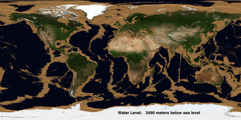
    Dunno, looks more like Mercury - burned to a crisp being so close to the sun.

    Load More Replies...
    Lotekguy
    Community Member
    Premium
    2 months ago Created by potrace 1.15, written by Peter Selinger 2001-2017

    Nuclear winter.

    Verena
    Community Member
    2 months ago Created by potrace 1.15, written by Peter Selinger 2001-2017

    Unfortunately it is much more lit in many areas.

    Roshan Kassan
    Community Member
    2 months ago Created by potrace 1.15, written by Peter Selinger 2001-2017

    My kid and i facepalmed at the same time seeing this

    PrettyJoyBird
    Community Member
    2 months ago Created by potrace 1.15, written by Peter Selinger 2001-2017

    Buhdumtss. Took me a few seconds 😅

    ADVERTISEMENT
    #14

    When You Try To Draw A Straight Line With A Ruler But Your Finger Has Other Pla

    Map showing Papua New Guinea with a mislabeled border splitting the island into two countries incorrectly.

    TerribleMaps Report

    Corvus
    Community Member
    2 months ago Created by potrace 1.15, written by Peter Selinger 2001-2017

    There actually was a case where a railroad was made like this because Stalin tried to draw a straight line on a map and his finger got in the way. Everyone was too afraid of him to argue (and with good reason!), so they just built it that way.

    #15

    A Pizza Map Of Italy

    Map of Italy creatively made as a pizza with toppings over a dark red background, illustrating funny and bad maps.

    Terrible Maps Report

    Forrest Hobbs
    Community Member
    2 months ago Created by potrace 1.15, written by Peter Selinger 2001-2017

    Hmm. Now I want to hear the Italian point of view - because that map's made of just one kind of pizza and doesn't accurately reflect regional variations. 🤨🤣

    Bill Swallow
    Community Member
    2 months ago Created by potrace 1.15, written by Peter Selinger 2001-2017

    I subscribe to the Vulcan philosophy of IPIC - Infinite Pizza in Infinite Combinations.

    Load More Replies...
    Abel
    Community Member
    2 months ago

    This comment has been deleted.

    #16

    Countries That Declared War On Birds… And Lost

    World map showing countries that declared war on birds and lost, a funny and bad map example.

    TerribleMaps Report

    David
    Community Member
    2 months ago Created by potrace 1.15, written by Peter Selinger 2001-2017

    This is incorrect, China won against the sparrows, they lost to the insect hordes after their sole predator was killed off

    pelemele
    Community Member
    2 months ago Created by potrace 1.15, written by Peter Selinger 2001-2017

    And it resulted in a major famine for humans, not a great victory.

    Load More Replies...
    Pieter LeGrande
    Community Member
    2 months ago Created by potrace 1.15, written by Peter Selinger 2001-2017

    China declared war on small birds, Australia declared war on very big birds - both lost, but it does show Australia tries harder.

    TotallyNOTAFox
    Community Member
    2 months ago (edited) Created by potrace 1.15, written by Peter Selinger 2001-2017

    Australia also suffered no casualities, unlike China with circa 35 million becomming victims of the Great Famine

    Load More Replies...
    Nicole Weymann
    Community Member
    2 months ago Created by potrace 1.15, written by Peter Selinger 2001-2017

    AFAIK China technically did win their war on sparrows. The prize was an exponential increase in insects. Turned out the sparrows' appetite for seeds was far less of a danger to the crops than the locusts they used to have for dessert (so to speak). (Wiki: "[The campaign] was one of the causes of the Great Chinese Famine which lasted from 1959 to 1961, with an estimated death toll due to starvation ranging in the tens of millions (15 to 55 million)") Talk about one epic Pyrrhic victory.

    Lotekguy
    Community Member
    Premium
    2 months ago Created by potrace 1.15, written by Peter Selinger 2001-2017

    One of them didn't fare so well against rabbits, either.

    Abel
    Community Member
    2 months ago Created by potrace 1.15, written by Peter Selinger 2001-2017

    The Kiwi Wars to invade Australia was brutal!

    Niki
    Community Member
    2 months ago Created by potrace 1.15, written by Peter Selinger 2001-2017

    Let this be a lesson to all. Do not mess with the dinosaur descendants!

    View more comments
    ADVERTISEMENT
    #17

    Cyclist Recreates Nirvana’s Iconic Nevermind Album Cover

    Map showing a funny and poorly drawn outline of Adelaide resembling a face in a humorous map collection.

    TerribleMaps Report

    HF
    Community Member
    2 months ago Created by potrace 1.15, written by Peter Selinger 2001-2017

    "can't talk now, I'm doing the willie!"

    ADVERTISEMENT
    #18

    Colossal Squid Sightings Around The World

    Polar map showing clustered fish icons around Antarctica in a humorous and inaccurate map style.

    TerribleMaps Report

    Min
    Community Member
    Premium
    2 months ago Created by potrace 1.15, written by Peter Selinger 2001-2017

    I'm more concerned about the massive penguins, to be honest.

    ohjojo (you/your's)
    Community Member
    2 months ago Created by potrace 1.15, written by Peter Selinger 2001-2017

    why are they all heading in the same direction?

    Jude Corrigan
    Community Member
    2 months ago Created by potrace 1.15, written by Peter Selinger 2001-2017

    If they represent giant squid. How big is the shark??

    #19

    What Earth Will Look Like In 250 Million Years, With Today’s Borders

    Inverted and distorted world map with countries oddly placed, showcasing a funny and poorly designed map illustration.

    TerribleMaps Report

    PrettyJoyBird
    Community Member
    2 months ago Created by potrace 1.15, written by Peter Selinger 2001-2017

    Would make for faster travel if Earth has not imploded by then.

    Gebidozo
    Community Member
    2 months ago Created by potrace 1.15, written by Peter Selinger 2001-2017

    Greenland bordering Western Sahara did it for me…

    Pieter LeGrande
    Community Member
    2 months ago Created by potrace 1.15, written by Peter Selinger 2001-2017

    Canada can share Australia's kangaroos then.

    Daria
    Community Member
    2 months ago Created by potrace 1.15, written by Peter Selinger 2001-2017

    Also, some may even show up in Austria at last :D

    Load More Replies...
    Abel
    Community Member
    2 months ago Created by potrace 1.15, written by Peter Selinger 2001-2017

    A Donut earth... Mmm.

    Doofnuts
    Community Member
    2 months ago Created by potrace 1.15, written by Peter Selinger 2001-2017

    If we all are still alive-- that looks like it would be fun, lol.

    ss
    Community Member
    2 months ago Created by potrace 1.15, written by Peter Selinger 2001-2017

    Putin will control it all, cuz nobody cares

    View more comments
    #20

    U.S. States With More Cows Than People

    US map showing states with more cows versus more people, highlighting a humorous and bad map design from a funny maps collection.

    TerribleMaps Report

    Doofnuts
    Community Member
    2 months ago Created by potrace 1.15, written by Peter Selinger 2001-2017

    So, this is saying, eat a people save a cow?

    Katie Bear
    Community Member
    2 months ago Created by potrace 1.15, written by Peter Selinger 2001-2017

    When you eat a people,don't eat it's brain, it can make you sick.

    Load More Replies...
    BrunoVI
    Community Member
    2 months ago Created by potrace 1.15, written by Peter Selinger 2001-2017

    Thus confirming my theory that cows vote Republican... (ICYMI, every one of the cow states is extremely Republican... but don't feel bad; the Democrats get most of the rest of the low-population states: Maine, Vermont, New Hampshire, Rhode Island, Delaware, Hawaii, New Mexico,...)

    Travis Fox
    Community Member
    2 months ago Created by potrace 1.15, written by Peter Selinger 2001-2017

    And yet they have more control over our political system than states with high population. So much for democracy and everyone's vote counting
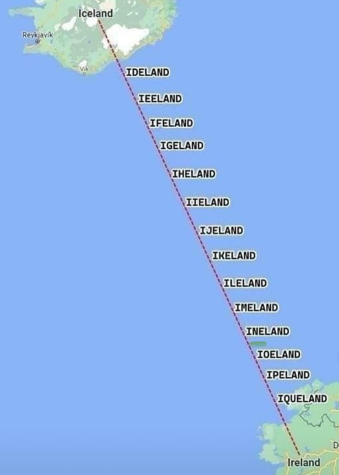
    Hailey Himalaylee
    Community Member
    2 months ago Created by potrace 1.15, written by Peter Selinger 2001-2017

    "Hm.. The watermark saws terrible maps... Seems legit"

    ss
    Community Member
    2 months ago Created by potrace 1.15, written by Peter Selinger 2001-2017

    Eat more chickin’

    ADVERTISEMENT
    #21

    New Zealand’s Snake Population Density

    Map showing snake population density in New Zealand with color scale from 0 to 100 snakes per hectare, funny maps SEO keyword.

    TerribleMaps Report

    Khavrinen
    Community Member
    2 months ago Created by potrace 1.15, written by Peter Selinger 2001-2017

    I didn't even know Saint Patrick had gone there...

    Norm Gilmore
    Community Member
    2 months ago Created by potrace 1.15, written by Peter Selinger 2001-2017

    But interestingly we do have Sea Snakes (occasionally) They get brought down in warmer sea currents to our shores every now and then. The interesting part? They can't be harmed and are protected as native wildlife. They don't survive for long because the waters around NZ are colder. https://www.doc.govt.nz/nature/native-animals/marine-fish-and-reptiles/sea-snakes-and-kraits/

    Socrates
    Community Member
    2 months ago Created by potrace 1.15, written by Peter Selinger 2001-2017

    That’s a lot of snakes surrounding the outside.

    PrettyJoyBird
    Community Member
    2 months ago Created by potrace 1.15, written by Peter Selinger 2001-2017

    What is the ♡ shaped island?

    ADVERTISEMENT
    #22

    Where Johnny Cash Claims To Have Traveled In “I’ve Been Everywhere”

    Funny map of the United States showing multiple identical faces humorously marking locations across many states.

    TerribleMaps Report

    tresgatos72
    Community Member
    2 months ago Created by potrace 1.15, written by Peter Selinger 2001-2017

    Not true - Alaska and Panama aren't on this map!

    Bryn
    Community Member
    2 months ago Created by potrace 1.15, written by Peter Selinger 2001-2017

    Yah they missed that the lyrics include some international destinations

    Load More Replies...
    #23

    Can You Legally Hunt Unicorns In Your State?

    Map showing states where hunting unicorns is legal, highlighting the humorous and bad map from funny maps collection.

    TerribleMaps Report

    Bob Brooce
    Community Member
    2 months ago Created by potrace 1.15, written by Peter Selinger 2001-2017

    Anyone know what it costs for a non-resident Unicorn license in Michigan? Asking for a friend.

    Lil be lil
    Community Member
    1 month ago Created by potrace 1.15, written by Peter Selinger 2001-2017

    Only Yupers and Trolls are allowed to hunt Unicorns in Michigan.

    Load More Replies...
    Allen Packard
    Community Member
    2 months ago Created by potrace 1.15, written by Peter Selinger 2001-2017

    Michigan Resident here, not worth it. They taste terrible.

    Gavin Johnson
    Community Member
    2 months ago Created by potrace 1.15, written by Peter Selinger 2001-2017

    Beware. If you elect to hunt unicorns then the wrath of Scotland will be visited upon you.. it’s their national animal, just ahead of the wild haggis.

    Sally Moen
    Community Member
    2 months ago Created by potrace 1.15, written by Peter Selinger 2001-2017

    Now I wonder how many unicorn hunting licenses they sell every year. 🤔 Or is it just a tag add-on to the regular license?

    BrunoVI
    Community Member
    2 months ago Created by potrace 1.15, written by Peter Selinger 2001-2017

    Sadly, this is why there are hardly any unicorns left in Michigan.

    Lil be lil
    Community Member
    1 month ago (edited) Created by potrace 1.15, written by Peter Selinger 2001-2017

    Same with Wolverines. The animal ones. Michigander here....

    Load More Replies...
    Marilyn Holt
    Community Member
    2 months ago Created by potrace 1.15, written by Peter Selinger 2001-2017

    You can still purchase canned unicorn meat on Amazon

    Lotekguy
    Community Member
    Premium
    2 months ago Created by potrace 1.15, written by Peter Selinger 2001-2017

    When is unicorn season? Asking for a friend.

    PrettyJoyBird
    Community Member
    2 months ago (edited) Created by potrace 1.15, written by Peter Selinger 2001-2017

    Okay Michigan 😶 lol #funfact

    View more comments
    #24

    Map Showing Which Countries Are The Hairiest

    World map displaying male androgenic hair distribution by region with color-coded percentages and a legend for reference.

    TerribleMaps Report

    Hugo
    Community Member
    2 months ago Created by potrace 1.15, written by Peter Selinger 2001-2017

    Disproves my theory that those who live in deserts don't need hair. But I'd advise all Greenlanders to wear a fur hat.

    TotallyNOTAFox
    Community Member
    2 months ago Created by potrace 1.15, written by Peter Selinger 2001-2017

    Hair is actually good protection against UV light - Curly hair is more effective than straight hair in that regard

    Load More Replies...
    Pieter LeGrande
    Community Member
    2 months ago Created by potrace 1.15, written by Peter Selinger 2001-2017

    As funded by the Hairdressers Federation as an aid to refugee hairdressers to determine the best country to move to.

    Mari
    Community Member
    2 months ago Created by potrace 1.15, written by Peter Selinger 2001-2017

    I thought Pakistan and India would be in the category 70%

    ADVERTISEMENT
    #25

    A Proposed Two-State Solution

    Map of the United States with red and blue sections and a labeled land bridge, featured in funny bad maps.

    TerribleMaps Report

    Son of Philosoraptor
    Community Member
    2 months ago Created by potrace 1.15, written by Peter Selinger 2001-2017

    Just buils the wall... Across the top of Florida. Every MAGA dupe can move there and live a f*****t paradise. Escape from FL will be the new action flick

    WindySwede
    Community Member
    2 months ago Created by potrace 1.15, written by Peter Selinger 2001-2017

    And who till play Snake Plissken?

    Load More Replies...
    Powerful Katrinka
    Community Member
    2 months ago Created by potrace 1.15, written by Peter Selinger 2001-2017

    They always leave out deep blue New Mexico, the first state in the country to offer free childcare for everyone who needs it. Also the first state to tell RFK Jr. to go pound sand.

    SchadenFreudian Psychology
    Community Member
    2 months ago Created by potrace 1.15, written by Peter Selinger 2001-2017

    IKR? And if they would draw the line just a little lower, Virginia would be safely in the blue zone. We’re a patchwork state. If it ever goes all red, I need to GTF out of here.

    Load More Replies...
    Robert Trebor
    Community Member
    2 months ago Created by potrace 1.15, written by Peter Selinger 2001-2017

    Alaska has replaced Mexico, and Hawaii is in the Caribbean

    Dan Cone
    Community Member
    2 months ago Created by potrace 1.15, written by Peter Selinger 2001-2017

    sees this: (Fumes in texan) we demand our own state

    George Costanza
    Community Member
    2 months ago Created by potrace 1.15, written by Peter Selinger 2001-2017

    There aren't red states and blue states. There are urban (blue) areas and rural (red) areas, present in all states. That's why there won't be any secession or civil war. There is no true division anymore.

    SchadenFreudian Psychology
    Community Member
    2 months ago Created by potrace 1.15, written by Peter Selinger 2001-2017

    Great. s/ So we’ll be having a cold civil war and fighting each other over every little thing and making things complicated and unpleasant until the end of time—because we aren’t allowed to treat the red-blue division like a divorce (admit it’s not working out, split up the property, and go our separate ways.)

    Load More Replies...
    Son of Philosoraptor
    Community Member
    2 months ago Created by potrace 1.15, written by Peter Selinger 2001-2017

    so we might insult delicate minds with the word fasc-ist? It's censored? Disgusting.

    Lotekguy
    Community Member
    Premium
    2 months ago Created by potrace 1.15, written by Peter Selinger 2001-2017

    I thought they bleeped "fvckwit". Either may suffice.

    Load More Replies...
    BrunoVI
    Community Member
    2 months ago Created by potrace 1.15, written by Peter Selinger 2001-2017

    Wouldn't it make much more sense for the land bridge to go across the top, so the red goesn't get divided? You could also extend the Southern blue through to El Paso.

    Tres D
    Community Member
    2 months ago

    This comment is hidden. Click here to view.

    PLEASE do NOT include Wisconsin in the blue hell!

    View more comments
    ADVERTISEMENT
    #26

    Australians When Surprised

    Simplified map of Norway in green, highlighting unusual or funny aspects of poorly drawn maps.

    Terrible Maps Report

    Smeghead Tribble Down Under
    Community Member
    2 months ago Created by potrace 1.15, written by Peter Selinger 2001-2017

    Actually, the more well-spoken among us use the term ''Fk me!''

    Pieter LeGrande
    Community Member
    2 months ago Created by potrace 1.15, written by Peter Selinger 2001-2017

    The rest say "bug*er me". End result is much the same of course.

    Load More Replies...
    Forrest Hobbs
    Community Member
    2 months ago Created by potrace 1.15, written by Peter Selinger 2001-2017

    Ahem. Some of us have heard of Geordies. "Whats the difference between a Kangaroo and a Kangaroot? A Kangaroo is a Marsupial native to Austalia A Kangaroot is what a Geordie says if hes stuck in a lift." https://www.readytogo.net/smb/threads/north-eastern-dialect-jokes.587740/page-3

    Abel
    Community Member
    2 months ago Created by potrace 1.15, written by Peter Selinger 2001-2017

    😀...🤦‍♂️

    PrettyJoyBird
    Community Member
    2 months ago Created by potrace 1.15, written by Peter Selinger 2001-2017

    Hilarious. I read it in Love Island Austrailia accent. 😝

    Anthony Elmore
    Community Member
    2 months ago Created by potrace 1.15, written by Peter Selinger 2001-2017

    Oh god, thank you. It took me far too long to get the joke 😂

    Load More Replies...
    #27

    Average Sneeze Speed Across Europe

    Map of Europe showing average speed limits by country with color coding from under 40 km/h to over 180 km/h, a funny bad map example.

    TerribleMaps Report

    Tiffany Sauter
    Community Member
    2 months ago Created by potrace 1.15, written by Peter Selinger 2001-2017

    I want to know the study that measured this.

    Abel
    Community Member
    2 months ago Created by potrace 1.15, written by Peter Selinger 2001-2017

    "Look, Spain is the first in something!" WTF!?

    Nicely
    Community Member
    2 months ago Created by potrace 1.15, written by Peter Selinger 2001-2017

    I want to see this cross referenced with average number of ahs before choo

    Bored Birgit
    Community Member
    2 months ago Created by potrace 1.15, written by Peter Selinger 2001-2017

    Never expected to see a map like this. I'm impressed. Gesundheit!

    View more comments
    #28

    Countries In Europe Whose National Animals Are Extinct Or Mythical

    Map of Europe showing mythical creatures associated with specific countries, part of a funny and bad map series.

    TerribleMaps Report

    Hugo
    Community Member
    2 months ago Created by potrace 1.15, written by Peter Selinger 2001-2017

    Well, at least someone can spell phoenix, if not aurochs.

    Poppy
    Community Member
    2 months ago Created by potrace 1.15, written by Peter Selinger 2001-2017

    Pretty sure Roosters are real

    TiNaBoNiNa
    Community Member
    2 months ago Created by potrace 1.15, written by Peter Selinger 2001-2017

    "The legend tells of a pilgrim wrongly accused of theft who proclaimed his innocence, stating a roasted rooster would crow to prove it. When the man was about to be hanged, the roasted rooster on the magistrate's table miraculously crowed, saving the pilgrim's life and proving his innocence."

    Load More Replies...
    Chewie Baron
    Community Member
    Premium
    2 months ago Created by potrace 1.15, written by Peter Selinger 2001-2017

    What about the two headed eagle?

    Lee Gilliland
    Community Member
    Premium
    2 months ago Created by potrace 1.15, written by Peter Selinger 2001-2017

    I hate to tell you but Grand Fenwick is fictional.

    Load More Replies...
    ADVERTISEMENT
    #29

    Kanawyers And Independence Are 20 Miles Apart, But The Road Trip Takes 300 Miles And Six Hours

    Map showing a long, unusual driving route through California near Sequoia and Death Valley National Parks.

    TerribleMaps Report

    PrettyJoyBird
    Community Member
    2 months ago Created by potrace 1.15, written by Peter Selinger 2001-2017

    Someone do a "walking" map through the National Forest

    Alex Martin
    Community Member
    2 months ago Created by potrace 1.15, written by Peter Selinger 2001-2017

    33.1 mile hike from the center of Independence. 8000 feet up and 7000 feet down. If you can get someone to drop you off at the trailhead its only 20 miles.

    Load More Replies...
    Pieter LeGrande
    Community Member
    2 months ago Created by potrace 1.15, written by Peter Selinger 2001-2017

    I guess a hot-air balloon is one answer.

    Rusty
    Community Member
    2 months ago Created by potrace 1.15, written by Peter Selinger 2001-2017

    This calls for a tunnel.

    ADVERTISEMENT
    #30

    When You Set Out To Map The World But Remember You’re A Chap From 1930s Britain

    Vintage world map from 1934 showing tea trade routes, highlighting major countries involved in historic tea commerce.

    TerribleMaps Report

    Forrest Hobbs
    Community Member
    2 months ago Created by potrace 1.15, written by Peter Selinger 2001-2017

    Yeah, only "A Tea Merchant's Chart AD 1934": this is obviously a joke about the point of view of a British tea merchant - what countries mattered to Brits trading in tea? No trade in South America to speak of, which is why it's so small. Lots of trade in China (obviously as a source of supply). Surely India would be bigger, though?

    AverageCommenter (she/they)
    Community Member
    2 months ago Created by potrace 1.15, written by Peter Selinger 2001-2017

    They really thought they were the biggest and best

    MsAnnThrope
    Community Member
    2 months ago Created by potrace 1.15, written by Peter Selinger 2001-2017

    I am fascinated by the uninformed and derogatory comments made about GB, which say more about the writers than about Britain. I am proud to be English with, and in spite of its long and varied history, than to be American with its doomed future.....

    Forrest Hobbs
    Community Member
    2 months ago Created by potrace 1.15, written by Peter Selinger 2001-2017

    MsAnnThrope: I'm English, but it's more of an accident of birth rather than a cause of pride if you ask me.

    Load More Replies...
    Caffeinated Ape
    Community Member
    2 months ago Created by potrace 1.15, written by Peter Selinger 2001-2017

    Giving the Mercator projection a run for its money with regards to landmass size distortion, I see.

    Abel
    Community Member
    2 months ago Created by potrace 1.15, written by Peter Selinger 2001-2017

    The Not so Great Brtain now, like the Mini Spanish Empire. Much better!

    Forrest Hobbs
    Community Member
    2 months ago (edited) Created by potrace 1.15, written by Peter Selinger 2001-2017

    Abel: the island is called Great Britain because it's the big one - initially "bigger than Ireland" (148 AD), and more recently "bigger than Brittany" (1136 AD). https://en.wikipedia.org/wiki/Great_Britain#Derivation_of_Great. Yes, the term is older than the English language.

    Load More Replies...
    Pieter LeGrande
    Community Member
    2 months ago Created by potrace 1.15, written by Peter Selinger 2001-2017

    Ben drinking too much green tea by the look of it.

    View more comments
    #31

    The World After An 8,800m Sea Rise

    Map showing an island labeled No Data and a small green dot named L’ile de Everest in a humorous bad maps style.

    TerribleMaps Report

    Ghostchaplain16
    Community Member
    Premium
    2 months ago Created by potrace 1.15, written by Peter Selinger 2001-2017

    Also known as Noah's Park. (I'll show myself out.)

    Abel
    Community Member
    2 months ago Created by potrace 1.15, written by Peter Selinger 2001-2017

    There is a documentary about this. It is called "Water World", narrated by Kevin Costner, and it is fantastic!

    Niki
    Community Member
    2 months ago Created by potrace 1.15, written by Peter Selinger 2001-2017

    The no data part worries me a bit.

    BrunoVI
    Community Member
    2 months ago Created by potrace 1.15, written by Peter Selinger 2001-2017

    I don't get it: why does Greenland get no data.

    ADVERTISEMENT
    #33

    U.S. States With The Highest Number Of Venomous Animals

    US map with states color-coded by a numerical range, illustrating a funny and poorly designed map with unclear data representation.

    TerribleMaps Report

    PrettyJoyBird
    Community Member
    2 months ago Created by potrace 1.15, written by Peter Selinger 2001-2017

    Really wow. So Texas is a mini Austrailia? Good to know.

    Min
    Community Member
    Premium
    2 months ago Created by potrace 1.15, written by Peter Selinger 2001-2017

    Arizona is a mini Australia.

    Load More Replies...
    Lotekguy
    Community Member
    Premium
    2 months ago Created by potrace 1.15, written by Peter Selinger 2001-2017

    This probably doesn't include the two-legged variety.

    Elio
    Community Member
    2 months ago Created by potrace 1.15, written by Peter Selinger 2001-2017

    Yeah go Arizona! We're number one!

    JD Key
    Community Member
    2 months ago Created by potrace 1.15, written by Peter Selinger 2001-2017

    Does this include maga people?

    Niki
    Community Member
    2 months ago Created by potrace 1.15, written by Peter Selinger 2001-2017

    I have questions, Alabama.

    Cole Earnhart
    Community Member
    2 months ago

    This comment has been deleted.

    Sally Moen
    Community Member
    2 months ago Created by potrace 1.15, written by Peter Selinger 2001-2017

    In my state, it's probably black widow spider and rattlesnake.

    View more comments
    ADVERTISEMENT
    #34

    Tiger Ownership Legality By U.S. State

    US map showing states with no regulations, permit requirements, or private ownership bans, a funny and bad map example.

    TerribleMaps Report

    Razill
    Community Member
    Premium
    2 months ago Created by potrace 1.15, written by Peter Selinger 2001-2017

    It always surprises my learners when i tell them i have treated numerous lion/tiger/big cat bites. Gotta love Nevada.

    Smeghead Tribble Down Under
    Community Member
    2 months ago Created by potrace 1.15, written by Peter Selinger 2001-2017

    This makes my blood boil >.< What sort of moron thinks a tiger, a FKN TIGER, makes a good pet?! It's horribly cruel for one thing, and very dangerous.

    Bob Brooce
    Community Member
    2 months ago Created by potrace 1.15, written by Peter Selinger 2001-2017

    Alabama: where it's illegal to wrestle a bear but legal to own a tiger.

    Lotekguy
    Community Member
    Premium
    2 months ago Created by potrace 1.15, written by Peter Selinger 2001-2017

    Florida bans ownership? That's surprisingly sane.

    Historyherstory (old guy)
    Community Member
    2 months ago (edited) Created by potrace 1.15, written by Peter Selinger 2001-2017

    Just keeping yall on your toes. :) We do have wild enclaves or parrots, monkeys, flamingos, and iguanas. Manatees also visit my dock routinely, who some research suggests are new to Florida in the last 5/600 years.

    Load More Replies...
    Niki
    Community Member
    2 months ago Created by potrace 1.15, written by Peter Selinger 2001-2017

    Well, this makes a bit of sense now.

    Laserleader
    Community Member
    2 months ago Created by potrace 1.15, written by Peter Selinger 2001-2017

    Alaska actually has a list of approved animals, and none of the local wildlife is on it.

    #35

    The Most Commonly Used Word In Each State’s Wikipedia Page

    Map of the United States with each state incorrectly labeled as "The," showing a funny and bad map error.

    TerribleMaps Report

    howdylee
    Community Member
    2 months ago Created by potrace 1.15, written by Peter Selinger 2001-2017

    Unless you're in Columbus, Ohio... then it's THE Ohio State.

    Abel
    Community Member
    2 months ago Created by potrace 1.15, written by Peter Selinger 2001-2017

    Mostly used in the common expression "WTF"

    Glen Ellyn
    Community Member
    Premium
    2 months ago Created by potrace 1.15, written by Peter Selinger 2001-2017

    Kind of a waste of a map if you ask me. ¯\_(ツ)_/¯

    #36

    States Where You Can Get Arrested For Wrestling A Bear

    Map of US states where you can get arrested for wrestling a bear, highlighted with humorous bear illustrations.

    TerribleMaps Report

    azubi
    Community Member
    2 months ago Created by potrace 1.15, written by Peter Selinger 2001-2017

    Did anyone ever manage to still get arrested after wrestling a bear?

    Bill Swallow
    Community Member
    2 months ago Created by potrace 1.15, written by Peter Selinger 2001-2017

    (The rest of the states figure there's no point in waiting for the remains to emerge from the bear's digestive tract just to arrest them. And in any case, the cops would refuse to put the cuffs on.)

    Lotekguy
    Community Member
    Premium
    2 months ago Created by potrace 1.15, written by Peter Selinger 2001-2017

    We need another map showing states in which the majority root for the bears.

    Sally Moen
    Community Member
    2 months ago Created by potrace 1.15, written by Peter Selinger 2001-2017

    Probably a holdover to the days of bear fights, using captive bears to fight with dogs, for entertainment. And I'm sure some big guys got involved

    PrettyJoyBird
    Community Member
    2 months ago Created by potrace 1.15, written by Peter Selinger 2001-2017

    Guess someone survived wrestling a bear in Louisiana...what even kind of bear would it be???

    Pieter LeGrande
    Community Member
    2 months ago Created by potrace 1.15, written by Peter Selinger 2001-2017

    Is this because only small bears live in these three states.

    ADVERTISEMENT
    #37

    A Topographic Map Of Africa

    Breaded fried food resembling a distorted map shape served with a lemon wedge on a white plate, humorous map fail.

    Terrible Maps Report

    Lotekguy
    Community Member
    Premium
    2 months ago (edited) Created by potrace 1.15, written by Peter Selinger 2001-2017

    What a delicious looking continent! Yum!

    For All Pedernity
    Community Member
    2 months ago Created by potrace 1.15, written by Peter Selinger 2001-2017

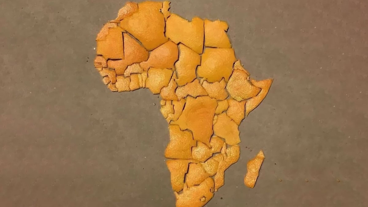
    This just barely looks like Africa, and the topography is not at all similar. Meh.

    ADVERTISEMENT
    #38

    How European Explorers Saw America In 1492

    Map showing distorted geography of Europe, Africa, and Greenland with missing and misplaced landmasses, highlighting funny bad maps.

    TerribleMaps Report

    Ghostchaplain16
    Community Member
    Premium
    2 months ago Created by potrace 1.15, written by Peter Selinger 2001-2017

    Amount of respect rest of the world has for the United States under its current leader. (American here who agrees.)

    8jw7gggk2v
    Community Member
    2 months ago Created by potrace 1.15, written by Peter Selinger 2001-2017

    I’m an American and I approve this message.

    Load More Replies...
    Stardust she/her
    Community Member
    2 months ago Created by potrace 1.15, written by Peter Selinger 2001-2017

    What happened to the North East and J&K lol? Sank under the sea despite being the highest points of the country?

    Auntriarch
    Community Member
    2 months ago Created by potrace 1.15, written by Peter Selinger 2001-2017

    They were only interested in the spices I suppose

    Load More Replies...
    View more comments
    #39

    The Great Italian Divide

    Map of Italy divided into butter and olive oil regions, illustrating a funny and bad food-themed map.

    TerribleMaps Report

    Francesca Annoni
    Community Member
    2 months ago Created by potrace 1.15, written by Peter Selinger 2001-2017

    I live in pianura padana.. in the map is placed in "olive oil " zone..but I I assure you that we are in the butter zone... lots of butter.. and parmesan cheese..

    Sally Moen
    Community Member
    2 months ago Created by potrace 1.15, written by Peter Selinger 2001-2017

    I had northern Italian food once. Very different, heavy on dairy

    #40

    The Earth, But Just Islands

    World map focusing on islands and regions with an unusual or funny representation in an ocean-dominated layout

    TerribleMaps Report

    Giles McArdell
    Community Member
    2 months ago Created by potrace 1.15, written by Peter Selinger 2001-2017

    That's Deep man, really deep! *(takes another pull on the joint)

    Load More Replies...
    Caffeinated Ape
    Community Member
    2 months ago Created by potrace 1.15, written by Peter Selinger 2001-2017

    OH come on! We're missing from a map of islands!? You'd think this would be the one with the most relevance to NZ. This has to be deliberate. This TerribleMap is terrible! 😂 Then again, maybe this one has been updated to reflect whatever caused us to be scribbled out on those other maps.

    Norm Gilmore
    Community Member
    2 months ago (edited) Created by potrace 1.15, written by Peter Selinger 2001-2017

    Hey!! Now map makers are just taking the urine. Island. North, South, Stewart.... :-)

    Poppy
    Community Member
    2 months ago Created by potrace 1.15, written by Peter Selinger 2001-2017

    I know Australia is called a continent but it's all one country so shouldn't it technically be called an island?

    CP
    Community Member
    2 months ago Created by potrace 1.15, written by Peter Selinger 2001-2017

    Continents are just big islands.

    Ilan Elron
    Community Member
    2 months ago Created by potrace 1.15, written by Peter Selinger 2001-2017

    very iffy - even contrived [vide: Suez, Corinth, Panama]

    Marilyn Holt
    Community Member
    2 months ago Created by potrace 1.15, written by Peter Selinger 2001-2017

    But really we're all islands, n'est-ce pas?

    Sally Moen
    Community Member
    2 months ago Created by potrace 1.15, written by Peter Selinger 2001-2017

    Lots of islands North of the Arctic Circle

    View more comments
    ADVERTISEMENT
    #41

    US States By Paid Sick Leave Laws In 2025

    US map showing states with paid sick leave laws, time off for any reason laws, and states without paid sick leave laws.

    TerribleMaps Report

    Multa Nocte (she/tiger quoll)
    Community Member
    2 months ago Created by potrace 1.15, written by Peter Selinger 2001-2017

    Does this sound horribly dystopian to anyone except me?

    arthbach
    Community Member
    2 months ago Created by potrace 1.15, written by Peter Selinger 2001-2017

    It's dystopian to everyone who lives in a first world country.

    Load More Replies...
    Bill Swallow
    Community Member
    2 months ago Created by potrace 1.15, written by Peter Selinger 2001-2017

    Well, even without laws, a lot of employers still offer paid sick leave. Not enough of them, though.

    Lotekguy
    Community Member
    Premium
    2 months ago Created by potrace 1.15, written by Peter Selinger 2001-2017

    Not many surprises here.

    John Dopplick
    Community Member
    2 months ago Created by potrace 1.15, written by Peter Selinger 2001-2017

    False, Missouri Republicans vetoes our voter approved sick pay. The republicans said you don't need it

    View more comments
    ADVERTISEMENT
    #42

    Is It Possible To Walk To Australia From Your Country?

    World map showing countries color-coded by whether you can walk to Australia, a funny and bad map example.

    TerribleMaps Report

    Robert Trebor
    Community Member
    2 months ago Created by potrace 1.15, written by Peter Selinger 2001-2017

    Why is New Zealand censored? Or have they been doing a lot of landfill?

    Janissary35680
    Community Member
    Premium
    2 months ago Created by potrace 1.15, written by Peter Selinger 2001-2017

    In the "Countries Googling Google" map, it's covered by a red scribble. What's going on? Are you OK, NZ?

    Load More Replies...
    Sally Moen
    Community Member
    2 months ago Created by potrace 1.15, written by Peter Selinger 2001-2017

    Wait, you can walk from the island of Tasmania to mainland Australia?

    Phantom Phoenix
    Community Member
    2 months ago Created by potrace 1.15, written by Peter Selinger 2001-2017

    In just 250 million years this map will be terribly inaccurate

    View more comments
    #43

    Where You Can Own A Monkey In The USA

    Map showing where owning a monkey is legal, illegal, or partially banned across the United States with humorous colors.

    TerribleMaps Report

    Sally Moen
    Community Member
    2 months ago Created by potrace 1.15, written by Peter Selinger 2001-2017

    I gotta look up when my state made it illegal. My best friend owned a squirrel monkey that tried to bite everyone. Never could understand the appeal

    Gingersnap In Iowa
    Community Member
    2 months ago Created by potrace 1.15, written by Peter Selinger 2001-2017

    When I was a kid, my aunt and uncle had a monkey.

    Auntriarch
    Community Member
    2 months ago Created by potrace 1.15, written by Peter Selinger 2001-2017

    That's no way to talk about your cousin 🤣

    Load More Replies...
    Russell Bowman
    Community Member
    2 months ago Created by potrace 1.15, written by Peter Selinger 2001-2017

    Curious ... in which states it is legal to "spank the monkey”

    #44

    Really Makes You Think

    Twitter post questioning tsunami caused by earthquake, overlaid on a funny bad world map with inaccurate geography markings.

    TerribleMaps Report

    Nicole Weymann
    Community Member
    2 months ago Created by potrace 1.15, written by Peter Selinger 2001-2017

    For my own peace of mind I'm choosing to believe he's not serious.

    Glix Drap
    Community Member
    2 months ago Created by potrace 1.15, written by Peter Selinger 2001-2017

    Some day I'll get around to explaining it to him.

    ADVERTISEMENT
    #45

    Countries Googling Google On Google In The Last Day

    World map with countries colored in various shades of blue and one country in red, illustrating funny bad maps.

    TerribleMaps Report

    Nathaniel He/Him Cis-Het
    Community Member
    2 months ago Created by potrace 1.15, written by Peter Selinger 2001-2017

    According to Jen the I.T. manager googling Google could break the Internet, so be careful!

    Jude Bennett
    Community Member
    2 months ago Created by potrace 1.15, written by Peter Selinger 2001-2017

    Why is New Zealand a red blob.

    Fat Harry (Oi / You)
    Community Member
    2 months ago Created by potrace 1.15, written by Peter Selinger 2001-2017

    It's north Korea, I think. Don't know why it's been moved over there.

    Load More Replies...
    Abel
    Community Member
    2 months ago Created by potrace 1.15, written by Peter Selinger 2001-2017

    New Zealand to the rescue! 😵‍💫

    Forrest Hobbs
    Community Member
    2 months ago Created by potrace 1.15, written by Peter Selinger 2001-2017

    I'm guessing that the "scribbling out of New Zealand" is just messing about due to the common problem of New Zealand being left off world maps entirely - since this whole thing is humour, someone decided to scribble out NZ for some sort of internet meme/joke sort of reason? 🤷

    Doofnuts
    Community Member
    2 months ago Created by potrace 1.15, written by Peter Selinger 2001-2017

    Why do I find this amount of tracking disturbing? Maybe it's just me.

    Ilan Elron
    Community Member
    2 months ago

    This comment has been deleted.

    Marilyn Holt
    Community Member
    2 months ago Created by potrace 1.15, written by Peter Selinger 2001-2017

    so everyone right now is going to Google Google. (Or may the)

    View more comments
    ADVERTISEMENT
    #46

    Fun Fact: Switzerland Is 18 The Gambias Away From Mongolia

    Map showing a colorful, inaccurate path crossing Europe and Asia, illustrating funny and bad map errors.

    TerribleMaps Report

    Pieter LeGrande
    Community Member
    2 months ago Created by potrace 1.15, written by Peter Selinger 2001-2017

    This will never catch on, we are so used to bananas by now.

    BrunoVI
    Community Member
    2 months ago Created by potrace 1.15, written by Peter Selinger 2001-2017

    Where do you think we get the bananas?

    Load More Replies...
    Eppe
    Community Member
    2 months ago Created by potrace 1.15, written by Peter Selinger 2001-2017

    The country N***r is cancelled again.

    Nicole Weymann
    Community Member
    2 months ago Created by potrace 1.15, written by Peter Selinger 2001-2017

    I love how "Ni​ger" was actually censored on the effing map. BTW "Nigeria" was spared.

    Trophy Husband
    Community Member
    2 months ago Created by potrace 1.15, written by Peter Selinger 2001-2017

    Was this unit of measure invented by an American?

    Sacred Panda
    Community Member
    2 months ago Created by potrace 1.15, written by Peter Selinger 2001-2017

    Why is a countries name censored!? N***r

    #47

    This Map Shows How Zealandia Might Look Today If It Had Stayed Above Sea Level

    Map of Australia and New Zealand with geographical labels, showcasing a humorous and inaccurate map design.

    TerribleMaps Report

    Pieter LeGrande
    Community Member
    2 months ago Created by potrace 1.15, written by Peter Selinger 2001-2017

    People are really messing with NZ.

    BrunoVI
    Community Member
    2 months ago Created by potrace 1.15, written by Peter Selinger 2001-2017

    Fun fact: from a plate tectonics point of view, the continents are North America, South America, Eurasia, Africa, Australia, Antarctica, Arabia, India, Madagascar and Central America/Carribean. Plates withuout continents (except on their edges) include Juan De Fuca (near British Columbia and Washington State), Pacific, Nazca (West of South America), Cocos (South of Mexico/ West of Central America), Philippine Oceanic (East of Philippines), and Scotia (extreme Southern Atlantic).

    #48

    The Most Likely Colour Of Your House In Europe

    Map of Europe with countries shaded in different colors, highlighting funny and bad map inaccuracies and distortions.

    TerribleMaps Report

    Leonard Hamers
    Community Member
    2 months ago Created by potrace 1.15, written by Peter Selinger 2001-2017

    Dutch houses are not that dark. Not accurate.

    Romy Schneider
    Community Member
    2 months ago Created by potrace 1.15, written by Peter Selinger 2001-2017

    I live in germany and my house has that colour. I'm dying.

    Multa Nocte (she/tiger quoll)
    Community Member
    2 months ago Created by potrace 1.15, written by Peter Selinger 2001-2017

    That's my true for both the places I've lived in France.

    Jaya
    Community Member
    2 months ago Created by potrace 1.15, written by Peter Selinger 2001-2017

    Dutch houses don't have that colour.

    Verena
    Community Member
    2 months ago Created by potrace 1.15, written by Peter Selinger 2001-2017

    It is correct for a lot of Dutch houses from before WWI. Houses built between WWI and the 1960s are mostly red brick, later ones come in a variety of colors. I live in a very old village, the oldest houses (about 50% of the builldings) are from the 1600s, they are that dark.

    AverageCommenter (she/they)
    Community Member
    2 months ago Created by potrace 1.15, written by Peter Selinger 2001-2017

    Leonard and Ellinor, have a rock paper scissors to see who’s right

    Hugo
    Community Member
    2 months ago Created by potrace 1.15, written by Peter Selinger 2001-2017

    We forgot to render our houses in the UK.

    Earonn -
    Community Member
    2 months ago Created by potrace 1.15, written by Peter Selinger 2001-2017

    It's all the Old Red Sandstone buildings. :D

    Load More Replies...
    Winter
    Community Member
    Premium
    2 months ago Created by potrace 1.15, written by Peter Selinger 2001-2017

    ?? Then I would have thought that Greece should have been "duck-egg blue"!!?

    View more comments
    ADVERTISEMENT
    See Also on Bored Panda
    #49

    Countries That Have Fined Google $20,000,000,000,000,000,000,000,000,000,000,000

    World map highlighting countries with yes, no, and no data categories in a humorous and inaccurate style.

    TerribleMaps Report

    BrunoVI
    Community Member
    2 months ago Created by potrace 1.15, written by Peter Selinger 2001-2017

    Well it's 20,000,000,000,000,000,000,000,000,000,000,000 rubles. So Google may be able to cover it.

    Load More Replies...
    JD Key
    Community Member
    2 months ago Created by potrace 1.15, written by Peter Selinger 2001-2017

    Dollars? Cause if that's actually rubles, it comes out to $4.37

    Miki
    Community Member
    2 months ago (edited) Created by potrace 1.15, written by Peter Selinger 2001-2017

    Soooo Greenland is still a possibility ;) naughty Greenland.

    Poppy
    Community Member
    2 months ago Created by potrace 1.15, written by Peter Selinger 2001-2017

    Is that US dollars and did they pay?

    TiNaBoNiNa
    Community Member
    2 months ago Created by potrace 1.15, written by Peter Selinger 2001-2017

    I'd believe it more if it were in rubles.

    Load More Replies...
    ADVERTISEMENT
    See Also on Bored Panda
    #50

    Can The Name Of This European Country Be Spelled Using Only Periodic Table Elements?

    Map of Europe highlighting countries that can have their names spelled using only periodic table elements, color-coded for accuracy.

    TerribleMaps Report

    azubi
    Community Member
    2 months ago Created by potrace 1.15, written by Peter Selinger 2001-2017

    Hey? What about germanium?

    Bill Swallow
    Community Member
    2 months ago (edited) Created by potrace 1.15, written by Peter Selinger 2001-2017

    Well, to spell 'Germany', you could start with Germanium (Ge), but then you'd need either an 'R' or an 'Rm' - neither of which exist on the periodic table. Alternatively, you could use 'Erbium' (Er), but then you'd need an unadorned 'G' to begin, and *that* doesn't exist on the periodic table, either, so...

    Load More Replies...
    Russell Bowman
    Community Member
    2 months ago (edited) Created by potrace 1.15, written by Peter Selinger 2001-2017

    Iodine (I) Cerium (CE) Lanthanum (LA) Neodymium (ND) ... Iceland

    Poppy
    Community Member
    2 months ago Created by potrace 1.15, written by Peter Selinger 2001-2017

    Pretty sure U and K are periodic elements, just not joined together

    Abel
    Community Member
    2 months ago Created by potrace 1.15, written by Peter Selinger 2001-2017

    Spain? S P...? Al is no Ai.

    alf martinez jaume
    Community Member
    2 months ago (edited) Created by potrace 1.15, written by Peter Selinger 2001-2017

    Sulphur (S), Protactinium (Pa), Indium (In)

    Load More Replies...
    #51

    Americans Were Asked To Identify The UK On A World Map

    World map showing inaccurate locations of the United Kingdom from a survey, illustrating funny and bad map errors.

    TerribleMaps Report

    Hey Kat
    Community Member
    2 months ago Created by potrace 1.15, written by Peter Selinger 2001-2017

    My countrymen really are pretty stupid aren't they? *sigh* Everyone knows that since it's not in the US, it isn't real!! /s :P

    David
    Community Member
    2 months ago Created by potrace 1.15, written by Peter Selinger 2001-2017

    most got it, so not bad

    Trophy Husband
    Community Member
    2 months ago Created by potrace 1.15, written by Peter Selinger 2001-2017

    What's with the ones where there is no land

    Lotekguy
    Community Member
    Premium
    2 months ago (edited) Created by potrace 1.15, written by Peter Selinger 2001-2017

    I'll bet the younger the American, the lower the percentage of accuracy. Boomer perspective on our downward trajectory.

    Phantom Phoenix
    Community Member
    2 months ago Created by potrace 1.15, written by Peter Selinger 2001-2017

    NZ: displayed, but overlooked. But displayed!

    Niki
    Community Member
    2 months ago Created by potrace 1.15, written by Peter Selinger 2001-2017

    I mean, had they been asked territories I might have let it slide...

    Miki
    Community Member
    2 months ago Created by potrace 1.15, written by Peter Selinger 2001-2017

    Ha, apparently I live in UK now.

    View more comments
    ADVERTISEMENT
    See Also on Bored Panda
    #52

    Exactly

    Tweet with a distorted map of Michigan showing a giant thumb and fingers, highlighting funny maps that are bad yet humorous.

    Terrible Maps Report

    LamarrKee
    Community Member
    2 months ago Created by potrace 1.15, written by Peter Selinger 2001-2017

    They mean a left-handed mitten.

    #53

    Prisons vs. Colleges By US State

    Map of US states showing more prisons or more colleges, highlighting differences in education and incarceration rates.

    TerribleMaps Report

    David
    Community Member
    2 months ago Created by potrace 1.15, written by Peter Selinger 2001-2017

    This is not accurate. This map is based off of data from a site Studee, which has numerous errors in their own calculations. They give Florida as 96 more prisons than they have, bc they include every county and city holding cell facility, but they do not use the same standard for Cali, where it is only actual prisons. And then they give Florida half the number of Universities they actually have, when Florida has actually 2x as many institutes of higher ed than prisons, when looking at the real number. Or for Cali, it is misleading, bc while Cali has more colleges than prisons, California has a smaller number of prisons with huge numbers inside, while florida has lots of smaller prisons. This map s misleading and incorrect

    Auntriarch
    Community Member
    2 months ago Created by potrace 1.15, written by Peter Selinger 2001-2017

    Dammit David, what's with all the facts and logic?

    Load More Replies...
    Michael Largey
    Community Member
    2 months ago (edited) Created by potrace 1.15, written by Peter Selinger 2001-2017

    Isn't it also the capacity of the colleges and prisons rather than just their raw numbers? A state might have 10 prisons housing 1,000 inmates each, but 5 colleges containing 10,000 students each. That's 10 prisons vs. 5 colleges, but 10,000 prisoners vs. 50,000 students.

    Lady Eowyn
    Community Member
    2 months ago Created by potrace 1.15, written by Peter Selinger 2001-2017

    Maryland has more colleges and universities than prisons and "correctional facilities. This map is wrong.

    Lotekguy
    Community Member
    Premium
    2 months ago Created by potrace 1.15, written by Peter Selinger 2001-2017

    No surprises here.

    Sally Moen
    Community Member
    2 months ago Created by potrace 1.15, written by Peter Selinger 2001-2017

    This isn't to say there are many prisons in most of these US states. It's just that there aren't so many colleges

    David
    Community Member
    2 months ago Created by potrace 1.15, written by Peter Selinger 2001-2017

    5,819 colleges with 19.28 million students between them.

    Load More Replies...
    Doofnuts
    Community Member
    2 months ago

    This comment is hidden. Click here to view.

    This comment has been deleted.

    View more comments
    ADVERTISEMENT
    See Also on Bored Panda
    #54

    Am I The Only One Who Sees An Elephant Doing The Front Crawl When I Look At The Mediterranean?

    Map with humorously inaccurate borders drawn over the Mediterranean region showing funny and bad map distortions.

    TerribleMaps Report

    ADVERTISEMENT
    See Also on Bored Panda
    #55

    Present-Day Ghana vs. Where The Ghana Empire Actually Was

    Map of Africa showing modern Ghana and the Ghana empire territories in red, green, and blue, a funny inaccurate map example.

    TerribleMaps Report

    #57

    Rule Brie-Tannia: God Save The Cream

    Map showing lactose digestion percentage in the Old World indigenous population with color-coded regions and data points.

    TerribleMaps Report

    Forrest Hobbs
    Community Member
    2 months ago Created by potrace 1.15, written by Peter Selinger 2001-2017

    Mmm. There's a different view here (the "intolerance rate" is given as a percentage when actually it's a fraction - when they say 1%, they mean 1 or 100%): https://worldpopulationreview.com/country-rankings/lactose-intolerance-by-country also: https://vividmaps.com/lactose-intolerance/

    ADVERTISEMENT
    See Also on Bored Panda
    #58

    The Drive So Dull Only Midwesterners Survive It

    Map showing inconsistent travel times and routes between Denver and Kansas City, illustrating funny and bad map errors.

    TerribleMaps Report

    Doug Moyer
    Community Member
    2 months ago Created by potrace 1.15, written by Peter Selinger 2001-2017

    Unfortunately, I have made this drive (and survived)...

    Lexi
    Community Member
    2 months ago Created by potrace 1.15, written by Peter Selinger 2001-2017

    Ok it's time to go to bed. I read that as trolls, and yes I got puzzled why only one was listed.

    sofacushionfort
    Community Member
    2 months ago Created by potrace 1.15, written by Peter Selinger 2001-2017

    Casper WY as the sun set, Lincoln NB as it rose. Be sure the wiper fluid reservoir is full with bug-strength juice.

    Selina Ali
    Community Member
    2 months ago Created by potrace 1.15, written by Peter Selinger 2001-2017

    The pros of living in England…

    Alecto76
    Community Member
    2 months ago Created by potrace 1.15, written by Peter Selinger 2001-2017

    I slept through this drive (as a passenger)

    Multa Nocte (she/tiger quoll)
    Community Member
    2 months ago Created by potrace 1.15, written by Peter Selinger 2001-2017

    Most of that consists of the trauma from the horror of having driven through Kansas City.

    ADVERTISEMENT
    See Also on Bored Panda
    #59

    Density Of Pig Farms Across Europe

    Map of Europe with black dots showing data points, illustrating an example of maps that are bad yet funny.

    TerribleMaps Report

    Pieter LeGrande
    Community Member
    2 months ago Created by potrace 1.15, written by Peter Selinger 2001-2017

    Plan your tour accordingly, or take several cans of air freshener.

    Nicole Weymann
    Community Member
    2 months ago Created by potrace 1.15, written by Peter Selinger 2001-2017

    I don't like the smell either - but chicken farms are at least as bad. I'd need that map, too, for proper planning.

    Load More Replies...
    For All Pedernity
    Community Member
    2 months ago Created by potrace 1.15, written by Peter Selinger 2001-2017

    Millions upon millions of horrible fates.

    Ilan Elron
    Community Member
    2 months ago Created by potrace 1.15, written by Peter Selinger 2001-2017

    Halal Norway? Or Kosher, Odin forbid?

    #60

    States Where Lassoing Fish Is Illegal

    US map highlighting Tennessee in orange as a state where it's illegal to lasso a fish, showcasing funny map facts.

    TerribleMaps Report

    #61

    Countries Featured In Poland’s Anthem

    Map of Europe showing countries color-coded by negative, positive, and neutral mentions, highlighting bad yet funny maps.

    TerribleMaps Report

    Sofia
    Community Member
    2 months ago Created by potrace 1.15, written by Peter Selinger 2001-2017

    w...why do they mention us? (I am italian)

    sofacushionfort
    Community Member
    2 months ago Created by potrace 1.15, written by Peter Selinger 2001-2017

    March! March, Dabrowski! March from Italy to Poland! Under your command We shall reach our land. (Polish general known for organizing the Polish Legions in Italy during the Napoleonic Wars)

    Load More Replies...
    Trophy Husband
    Community Member
    2 months ago Created by potrace 1.15, written by Peter Selinger 2001-2017

    This is really interesting: https://www.classicfm.com/discover-music/periods-genres/national-anthems/lyrics-poland-mazurek-dbrowskiego-english-translation/

    Silberwolf
    Community Member
    2 months ago Created by potrace 1.15, written by Peter Selinger 2001-2017

    What did Sweden do to Poland?

    Miki
    Community Member
    2 months ago (edited) Created by potrace 1.15, written by Peter Selinger 2001-2017

    XVII century war. It was so bad we are calling it "Swedish Deluge" https://en.m.wikipedia.org/wiki/Northern_War_of_1655%E2%80%931660

    Load More Replies...
    Foxglove🇮🇪
    Community Member
    2 months ago Created by potrace 1.15, written by Peter Selinger 2001-2017

    I need a translation of the anthem now!

    Miki
    Community Member
    2 months ago Created by potrace 1.15, written by Peter Selinger 2001-2017

    Here it is: https://www.spiewnikniepodleglosci.pl/en/lyrics/lyrics-polish-national-anthem/

    Load More Replies...
    OneHappyPuppy
    Community Member
    2 months ago Created by potrace 1.15, written by Peter Selinger 2001-2017

    I'm more curious as to how Germany is mentioned positively, because, you know, the 40s?

    Bored Birgit
    Community Member
    2 months ago Created by potrace 1.15, written by Peter Selinger 2001-2017

    No, Germany is dark red = indirectly mentioned negatively.

    Load More Replies...
    Corvus
    Community Member
    2 months ago Created by potrace 1.15, written by Peter Selinger 2001-2017

    From the anthem: "Poland has not yet perished, so long as we still live." - You don't say! :D

    Miki
    Community Member
    2 months ago (edited) Created by potrace 1.15, written by Peter Selinger 2001-2017

    Sorry Sweden. There is a reason why what happend in XVII century we call "Swedish Deluge" :D

    View more comments
    ADVERTISEMENT
    #62

    I Mean, I’ve Seen Worse Ideas

    Side-by-side comparison of maps showing Italy shaped like Florida, illustrating funny bad map designs.

    TerribleMaps Report

    Earonn -
    Community Member
    2 months ago Created by potrace 1.15, written by Peter Selinger 2001-2017

    No thanks. You can keep your Alligator Auschwitz and all the crazies.

    Nicole Weymann
    Community Member
    2 months ago Created by potrace 1.15, written by Peter Selinger 2001-2017

    I see why the US might want to get closer to *actual* pizza, but speaking for the rest of Europe: we're NOT giving up access to the Amalfi coast, historic sites, and gelato in exchange for Florida man and Disney World. 😤

    Yrral Spavit
    Community Member
    2 months ago Created by potrace 1.15, written by Peter Selinger 2001-2017

    Italy looks cool, Florida looks like a limp d**k.

    BrunoVI
    Community Member
    2 months ago Created by potrace 1.15, written by Peter Selinger 2001-2017

    Why does Florida look more obscene in the Mediterranean?

    DC
    Community Member
    2 months ago Created by potrace 1.15, written by Peter Selinger 2001-2017

    We won't change Maserati and Pasta for ... for ... for what, exactly? Florida Man and his exciting antics?

    Eggwodd
    Community Member
    Premium
    2 months ago Created by potrace 1.15, written by Peter Selinger 2001-2017

    I'll give up Disney World for good food n wine any day.

    sofacushionfort
    Community Member
    2 months ago Created by potrace 1.15, written by Peter Selinger 2001-2017

    Long ago both Naples Florida and Naples Italy were ruled by the Hapsburgs

    For All Pedernity
    Community Member
    2 months ago Created by potrace 1.15, written by Peter Selinger 2001-2017

    Worse ideas? This IS the worst! No, thank you.

    View more comments
    ADVERTISEMENT
    #63

    The Shortest Route From Santiago, Chile To Ulaanbaatar, Mongolia

    Satellite view of a world map showing a curved distance line from South America to Asia, part of funny bad maps collection.

    TerribleMaps Report

    Ilan Elron
    Community Member
    2 months ago Created by potrace 1.15, written by Peter Selinger 2001-2017

    short in miles, but discounting truly awful traffic jams in Greenland

    Cristi nah
    Community Member
    2 months ago (edited) Created by potrace 1.15, written by Peter Selinger 2001-2017

    I would like to go from Ulaanbaatar to Ushuaia because the names are so cool

    Russell Bowman
    Community Member
    2 months ago Created by potrace 1.15, written by Peter Selinger 2001-2017

    Wouldn't the southern Great Circle be shorter?

    BrunoVI
    Community Member
    2 months ago Created by potrace 1.15, written by Peter Selinger 2001-2017

    No, because Santiago is way closer to the N.H. than Ulaanbataar is to the S.H.

    Load More Replies...
    #64

    Berlin Is Approximately 7 Belgiums Away From Moscow

    Map highlighting an oddly shaped route through Poland, Belarus, and Russia, showcasing funny and bad map design.

    TerribleMaps Report

    SCP 4666
    Community Member
    2 months ago Created by potrace 1.15, written by Peter Selinger 2001-2017

    Anything but the metric system

    Lotekguy
    Community Member
    Premium
    2 months ago Created by potrace 1.15, written by Peter Selinger 2001-2017

    How many bananas in a Belgium?

    TiNaBoNiNa
    Community Member
    2 months ago Created by potrace 1.15, written by Peter Selinger 2001-2017

    The length of Belgium is ~280 km. The average banana is ~19 cm long. So, Belgium is 1,473,684.21 bananas in length. x7=10,315,789.47 bananas. My math skills aren't good enough to calculate square km, but if anyone wants to do it, Belgium is 30,689 square km.

    Load More Replies...
    Trophy Husband
    Community Member
    2 months ago Created by potrace 1.15, written by Peter Selinger 2001-2017

    Now I want a reason to use this new unit of measure... Yes, I am American, why do you ask?

    For All Pedernity
    Community Member
    2 months ago Created by potrace 1.15, written by Peter Selinger 2001-2017

    Well, if you're American you don't need a reason, do you? You're already using a nonsensical measurement system, so adding 'belgium' to it sounds OK.

    Load More Replies...
    For All Pedernity
    Community Member
    2 months ago Created by potrace 1.15, written by Peter Selinger 2001-2017

    Inaccurate measurements annoy me. It's 5,5 Belgiums between Moscow and Berlin. Skjermbild...db-png.jpg Skjermbilde-2025-09-30-133822-68dbc160e7cdb-png.jpg

    For All Pedernity
    Community Member
    2 months ago

    This comment has been deleted.

    #65

    The Neighborhoods Of New York City

    Color-coded map of Manhattan neighborhoods with humorous and confusing labels highlighting bad yet funny map design.

    TerribleMaps Report

    David
    Community Member
    2 months ago Created by potrace 1.15, written by Peter Selinger 2001-2017

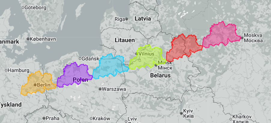
    I have seen this map many times, and as a New Yorker, it is not accurate. LES goes further south and not as far west as they show for example. Among other things, and also 4 of these are not actual neighborhoods but nicknames for sections of neighborhoods, and 1 hasnt existed in over 90 years.

    Foxglove🇮🇪
    Community Member
    2 months ago Created by potrace 1.15, written by Peter Selinger 2001-2017

    Plus it only covers Manhattan, not the outer districts like Queens, Long Island etc

    Load More Replies...
    Marilyn Holt
    Community Member
    2 months ago Created by potrace 1.15, written by Peter Selinger 2001-2017

    Still--this is somewhat helpful with some mystery books I've read

    PrettyJoyBird
    Community Member
    2 months ago Created by potrace 1.15, written by Peter Selinger 2001-2017

    Not sure how accurate it is but all the different neighborhood personalities squished so closed together like this has always fascinated me.

    ADVERTISEMENT
    #66

    Stereotype Map Of New England

    Humorous and inaccurate maps highlighting New England stereotypes and funny regional misconceptions.

    TerribleMaps Report

    Sally Moen
    Community Member
    2 months ago Created by potrace 1.15, written by Peter Selinger 2001-2017

    My geography is western-oriented. I imagine Boston as being south of New York City.

    Arthur Waite
    Community Member
    Premium
    2 months ago Created by potrace 1.15, written by Peter Selinger 2001-2017

    Shout out to Canada! Bonjour!

    ADVERTISEMENT
    #67

    The Size Of Texas Compared To The Moon And Dwarf Planets

    Map showing the size comparison of dwarf planets Ceres, Pluto, and Moon relative to Texas in a funny bad map style.

    TerribleMaps Report

    Nathaniel He/Him Cis-Het
    Community Member
    2 months ago Created by potrace 1.15, written by Peter Selinger 2001-2017

    Texas is so big you could fit Texas inside it's borders.

    Trophy Husband
    Community Member
    2 months ago Created by potrace 1.15, written by Peter Selinger 2001-2017

    Pluto is a planet!!!!!!!!!

    View more comments
    #68

    You Can Sail In A Straight Line From Georgia To Georgia

    Map showing the confusion between Georgia in the USA and Georgia the country, highlighting funny and bad map errors.

    TerribleMaps Report

    T'Mar of Vulcan
    Community Member
    2 months ago Created by potrace 1.15, written by Peter Selinger 2001-2017

    Just an old sweet song keeps Georgia on my mind...

    For All Pedernity
    Community Member
    2 months ago Created by potrace 1.15, written by Peter Selinger 2001-2017

    Show this to Trump and he'll have Musk build a Tesla tunnel.

    Alex Martin
    Community Member
    2 months ago Created by potrace 1.15, written by Peter Selinger 2001-2017

    Sure you can if you delete Türkiye, France, Spain, Portugal, Italy, Greece, and the Balkans.

    Ilan Elron
    Community Member
    2 months ago Created by potrace 1.15, written by Peter Selinger 2001-2017

    Microsoft Paint steer excrement

    #69

    First To Open In Each State: Target Or Walmart

    US map showing states where Walmart or Target opened first, illustrating a funny and bad map example from 89 maps.

    TerribleMaps Report

    Bob Brooce
    Community Member
    2 months ago Created by potrace 1.15, written by Peter Selinger 2001-2017

    The only time it's bad to be a blue state.

    BrunoVI
    Community Member
    2 months ago (edited) Created by potrace 1.15, written by Peter Selinger 2001-2017

    You like paying more for far fewer options? UPDATE: I see where Target has reduced its dependency on Chinese c**p far more than Walmart. So that's a decent reason to shop Target.

    Load More Replies...
    ADVERTISEMENT
    #70

    A Useful Map For New Yorkers In La

    Map humorously mislabeling Los Angeles areas as New York boroughs, showcasing funny bad maps with inaccurate geography.

    TerribleMaps Report

    ADVERTISEMENT
    #71

    Countries Where The Local Name Is Extremely Different From The English Version

    Map showing country names in their native languages across Europe, Africa, and Asia for humorous map SEO content.

    TerribleMaps Report

    David
    Community Member
    2 months ago Created by potrace 1.15, written by Peter Selinger 2001-2017

    for India Bharat is only in Hindi, not all the languages there, and while they are talking about changing its official nake to Bharat, their legal name in their own country is India.

    Stardust she/her
    Community Member
    2 months ago Created by potrace 1.15, written by Peter Selinger 2001-2017

    False, in most of the official languages of the country we refer to our own country as Bharat. In fact, I’d wager that most of our languages refer to our country as Bharat because the word is derived from the Sanksrit word Bharata which has many meanings but one of them I remember is that Bharata refers to a mythological king of our country thousands of years ago who had managed to stretch his kingdom all the way from the North Eastern states to Afghanistan.

    Load More Replies...
    Space Invader
    Community Member
    2 months ago Created by potrace 1.15, written by Peter Selinger 2001-2017

    Austria is missing - unless you consider "Österreich" to be the same name

    Heffalump
    Community Member
    2 months ago Created by potrace 1.15, written by Peter Selinger 2001-2017

    I do. The spelling is different, but 'Austria' is clearly derived from 'Österreich' when pronounced.

    Load More Replies...
    Corvus
    Community Member
    2 months ago Created by potrace 1.15, written by Peter Selinger 2001-2017

    Egypt is Misr... but the city of Misrata is in Libya, curiously.

    For All Pedernity
    Community Member
    2 months ago Created by potrace 1.15, written by Peter Selinger 2001-2017

    Hrvatska and Croatia aren't that different. Croatia is the Latinisation of the Slavic name. Crna Gora is the same name as Montenegro, just in Montenegrin, so actually not 'extremely different'.

    #72

    Pluto vs. The State Of Alaska

    Map of Alaska outlined in red over the surface of a planet, illustrating one of the funny and bad maps.

    TerribleMaps Report

    Ghostchaplain16
    Community Member
    Premium
    2 months ago Created by potrace 1.15, written by Peter Selinger 2001-2017

    The world started to fall apart as soon as we decided Pluto wasn't a planet. Sigh!

    Robert Trebor
    Community Member
    2 months ago Created by potrace 1.15, written by Peter Selinger 2001-2017

    I feel badly for Pluto's demotion. It seems so unfair. Poor Pluto did nothing wrong.

    Auntriarch
    Community Member
    2 months ago Created by potrace 1.15, written by Peter Selinger 2001-2017

    Oh no, Alaska has migrated again!

    Bill Swallow
    Community Member
    2 months ago Created by potrace 1.15, written by Peter Selinger 2001-2017

    Nah - we just put it out of reach of Putin's grubby little mitts.

    Load More Replies...
    View more comments
    #73

    Every State’s Most Disturbing Sports Mascot

    Map of the United States showing each state's most disturbing sports mascot in a funny and bad design style.

    TerribleMaps Report

    Bill Swallow
    Community Member
    2 months ago Created by potrace 1.15, written by Peter Selinger 2001-2017

    So, if it's the most disturbing, the rest must be spectacular!

    Load More Replies...
    TFFFan328
    Community Member
    2 months ago Created by potrace 1.15, written by Peter Selinger 2001-2017

    Oh, gosh. Our Norfolk Tides mascot Triton the Sea Horse...yeah, he's a pretty odd choice... Virginia...minor league baseball...farm team for the Baltimore Orioles

    TiNaBoNiNa
    Community Member
    2 months ago Created by potrace 1.15, written by Peter Selinger 2001-2017

    Oregon has the Hillsboro Hops with a hops vine bud. There's also a new soccer club called the Bangers whose mascot is a sausage. The Portland Pickles have Dillon the Pickle.

    Pheebs
    Community Member
    2 months ago Created by potrace 1.15, written by Peter Selinger 2001-2017

    Lol. New York - Syracuse Orangemen by the looks of it. Not sure why it’s disturbing. More silly, I’d think.

    CP
    Community Member
    2 months ago Created by potrace 1.15, written by Peter Selinger 2001-2017

    Steely McBeam is more disturbing than Gritty (Pennsylvania). Gritty is cool and I say that as a Penguins fan.

    Daniel Atkins
    Community Member
    2 months ago (edited) Created by potrace 1.15, written by Peter Selinger 2001-2017

    I don't know the Penn State Nittney LIon is pretty bad https://encrypted-tbn3.gstatic.com/images?q=tbn:ANd9GcQozR7gfRKLzbu8jSJlshqf6zeMu8QHs-BlGO8YbYOLimvfmMmkSI0ShrVwBxjOgqeP9X5o7Bf19dJyzh9zbXBGtLA3pAFWAZQM9BClD_32Og

    Load More Replies...
    ADVERTISEMENT
    #74

    The Top “Why Is [state] So…” Question For Each Aussie State

    Humorous map of Australia with states color-coded as big, conservative, hot, populated, bad, small, famous, and sparsely populated.

    TerribleMaps Report

    Pieter LeGrande
    Community Member
    2 months ago Created by potrace 1.15, written by Peter Selinger 2001-2017

    ACT is medium blue, Victoria is dark blue, Tasmania is dark green.

    BrunoVI
    Community Member
    2 months ago Created by potrace 1.15, written by Peter Selinger 2001-2017

    Australia, where the locals think it's wierd to be populated.

    PrettyJoyBird
    Community Member
    2 months ago Created by potrace 1.15, written by Peter Selinger 2001-2017

    Which ones are the Small (Dark Blue) and Famous (Green)?

    mtownmick
    Community Member
    2 months ago Created by potrace 1.15, written by Peter Selinger 2001-2017

    Small - Australia Capital Territory, Famous - Tasmania

    Load More Replies...
    ADVERTISEMENT
    #75

    U.S. States With The Most (And Least) Attractive People

    Map showing the ranking of most attractive states in the US with color gradients from most to least attractive.

    TerribleMaps Report

    tresgatos72
    Community Member
    2 months ago Created by potrace 1.15, written by Peter Selinger 2001-2017

    Hmmm, the states with the highest MAGA population are also the least attractive. Who would have thought it? 🤔

    CD King
    Community Member
    2 months ago Created by potrace 1.15, written by Peter Selinger 2001-2017

    The states with the least money seem to be at the bottom of the pile…

    Eggwodd
    Community Member
    Premium
    2 months ago (edited) Created by potrace 1.15, written by Peter Selinger 2001-2017

    Excuse me? They obviously have not been to NJ.

    Hey Kat
    Community Member
    2 months ago Created by potrace 1.15, written by Peter Selinger 2001-2017

    New Jersey is #1?? Have they been there? Are they using the Snooki as a guide?

    Doug Moyer
    Community Member
    2 months ago Created by potrace 1.15, written by Peter Selinger 2001-2017

    I was a solid 8 back in Missouri, but unfortunately I live in California now...

    TiNaBoNiNa
    Community Member
    2 months ago Created by potrace 1.15, written by Peter Selinger 2001-2017

    Proud to be mediocre in Oregon!

    Pheebs
    Community Member
    2 months ago Created by potrace 1.15, written by Peter Selinger 2001-2017

    Florida is not surprising in the middle - lots of retirees, and people who over-bake in the sun. This is balanced by those of us sho avoid the sun during most months because of the UV index, so are lacking vitamin D.

    View more comments
    #76

    The Legality Of Flamethrower Ownership In The United States

    Map of US states showing legality status with color codes, an example of a funny and bad map from terrible maps collection.

    TerribleMaps Report

    #77

    What A Masterpiece. Absolute Chaos - Couldn't Have Designed It Better Myself. If You’re English, You Know

    Confusing road interchange map showing overlapping highways with labels M6 and A38(M) near Aston Expressway.

    TerribleMaps Report

    martin734
    Community Member
    2 months ago Created by potrace 1.15, written by Peter Selinger 2001-2017

    Gravelly Hill interchange, commonly known as Spaghetti Junction.

    Forrest Hobbs
    Community Member
    2 months ago Created by potrace 1.15, written by Peter Selinger 2001-2017

    When you're driving on it, it's pretty boring (a fact which irritated me when I was little - I wanted it to be more excitingly chaotic). More here: https://en.wikipedia.org/wiki/Spaghetti_Junction%2C_Birmingham

    Load More Replies...
    Bill Swallow
    Community Member
    2 months ago Created by potrace 1.15, written by Peter Selinger 2001-2017

    The 'Mixing Bowl', in the Northern Virginia DC suburbs, sneers at this beginner.

    Russell Bowman
    Community Member
    2 months ago Created by potrace 1.15, written by Peter Selinger 2001-2017

    I am sure a demon called Crowley had something to do with it ... obscure literary reference

    martin734
    Community Member
    2 months ago Created by potrace 1.15, written by Peter Selinger 2001-2017

    I think he did the M25 too, In the shape of a particular sigil.

    Load More Replies...
    Niki
    Community Member
    2 months ago Created by potrace 1.15, written by Peter Selinger 2001-2017

    Who put Celtic knotwork on the map?!

    SchadenFreudian Psychology
    Community Member
    2 months ago Created by potrace 1.15, written by Peter Selinger 2001-2017

    In Springfield, VA, there’s a tangle of roads called the Mixing Bowl.

    Foxglove🇮🇪
    Community Member
    2 months ago Created by potrace 1.15, written by Peter Selinger 2001-2017

    Been through it many times, a marvel of engineering design

    ADVERTISEMENT
    #78

    Wyoming Has A Lower Population Than The Other 49 States Combined

    Map of the United States with Wyoming highlighted in red among blue states, illustrating funny and bad map design examples.

    TerribleMaps Report

    ADVERTISEMENT
    #80

    Map Of The Donbas Region Putin Proposed Ukraine Should Cede In Exchange For Ending The Fighting

    Map showing recent Russian advances and control in eastern Ukraine, highlighting Donbas region and surrounding oblasts.

    TerribleMaps Report

    sofacushionfort
    Community Member
    2 months ago Created by potrace 1.15, written by Peter Selinger 2001-2017

    And then he’ll never bother you again

    LamarrKee
    Community Member
    2 months ago Created by potrace 1.15, written by Peter Selinger 2001-2017

    You forgot the '/s' to denote your sarcasm.

    Load More Replies...
    Earonn -
    Community Member
    2 months ago Created by potrace 1.15, written by Peter Selinger 2001-2017

    You need a lot of land to make up for Man-tit Putin's inferiority complex.

    For All Pedernity
    Community Member
    2 months ago (edited) Created by potrace 1.15, written by Peter Selinger 2001-2017

    Not accurate. Russia claims all of these four regions, not just what they now occupy, as well as Crimea.

    DC
    Community Member
    2 months ago Created by potrace 1.15, written by Peter Selinger 2001-2017

    Yeah, well, no. Go FÜCK yourself - would anybody else, even? - Diktatorewitsch!

    #81

    What France’s Borders Looked Like Briefly In 1866

    Outline of France and an incorrectly large map area overlapping parts of Italy and Switzerland, a funny map error.

    TerribleMaps Report

    For All Pedernity
    Community Member
    2 months ago Created by potrace 1.15, written by Peter Selinger 2001-2017

    'Briefly' meaning half an hour on 16th of October. Ceded to the French by Austria-Hungary on the condition that France gave it to Italy.

    Sofia
    Community Member
    2 months ago Created by potrace 1.15, written by Peter Selinger 2001-2017

    corsica is STILL part of france

    ADVERTISEMENT
    ADVERTISEMENT
    #83

    Map Of What Europeans Think Is The ‘South’ In The USA

    Map of the United States highlighting southern states in red, showcasing a humorous take on regional boundaries.

    TerribleMaps Report

    Razill
    Community Member
    Premium
    2 months ago Created by potrace 1.15, written by Peter Selinger 2001-2017

    Californians gonna get very offended

    Bryn
    Community Member
    2 months ago Created by potrace 1.15, written by Peter Selinger 2001-2017

    I'm not Californian and this line annoys me as it's not correct

    Load More Replies...
    Mike Barrette
    Community Member
    2 months ago Created by potrace 1.15, written by Peter Selinger 2001-2017

    No to California, Arizona, New Mexico

    PrettyJoyBird
    Community Member
    2 months ago (edited) Created by potrace 1.15, written by Peter Selinger 2001-2017

    Based off original South vs North Cival War not directionally as it sounds. But honestly close enough.

    Load More Replies...
    Bill Swallow
    Community Member
    2 months ago Created by potrace 1.15, written by Peter Selinger 2001-2017

    Considering 90% of everything in Virginia is named 'Lee' (and the other 10% is named for other Confederates), it's classification as 'North' comes as quite a surprise.

    Michael Largey
    Community Member
    2 months ago Created by potrace 1.15, written by Peter Selinger 2001-2017

    I can attest that Indiana is the northern-most southern state.

    sofacushionfort
    Community Member
    2 months ago Created by potrace 1.15, written by Peter Selinger 2001-2017

    You can include most of Pennsylvania

    Pieter LeGrande
    Community Member
    2 months ago Created by potrace 1.15, written by Peter Selinger 2001-2017

    I would have left out CA, but otherwise that's about right.

    For All Pedernity
    Community Member
    2 months ago Created by potrace 1.15, written by Peter Selinger 2001-2017

    I have never met another European that considers California to be in the South.

    BrunoVI
    Community Member
    2 months ago Created by potrace 1.15, written by Peter Selinger 2001-2017

    Not traditionally considered the South: California, New Mexico, Arizona. But Arizona is kinda the South. Traditionally considered the South: Kentucky, West Virginia, Virginia. Virginia is now dominated by DC which is the antithesis of the South if ever there was one. Boston is more like the South than DC. Sorta southernish in some ways: Southern Missouri, Southern Ohio, even Southern New Jersey. Not kidding: the redneckiest place I've ever been was in the counties surrounding Atlantic City.

    View more comments
    #84

    A Map Of Every Country That Starts With A Capital Letter

    World map showing countries colored by whether their names begin with a capital letter, illustrating funny bad map errors.

    TerribleMaps Report

    Auntriarch
    Community Member
    2 months ago (edited) Created by potrace 1.15, written by Peter Selinger 2001-2017

    eSwatini has something to say about that

    Forrest Hobbs
    Community Member
    2 months ago Created by potrace 1.15, written by Peter Selinger 2001-2017

    Likewise 中华人民共和国 (that's Chinese for "The People's Republic of China" - written Chinese doesn't have capital or lower case letters). https://en.wikipedia.org/wiki/China. Other writing systems might also apply for recognition...

    Load More Replies...
    Pieter LeGrande
    Community Member
    2 months ago Created by potrace 1.15, written by Peter Selinger 2001-2017

    Is that the English name or the local name?

    For All Pedernity
    Community Member
    2 months ago (edited) Created by potrace 1.15, written by Peter Selinger 2001-2017

    I think there's pretty conclusive data on Greenland, Western Sahara and North Korea.

    Niki
    Community Member
    2 months ago Created by potrace 1.15, written by Peter Selinger 2001-2017

    The no data bit bothers me agaib.....

    #85

    States Most Likely To Survive An Alien Invasion

    Map highlighting US states most likely to survive an alien invasion, featuring a humorous and poorly designed map layout.

    TerribleMaps Report

    Bill Swallow
    Community Member
    2 months ago Created by potrace 1.15, written by Peter Selinger 2001-2017

    New Jersey handled the Martians / Red Lectroids back in 1938, so they get a pass.

    Michael Largey
    Community Member
    2 months ago Created by potrace 1.15, written by Peter Selinger 2001-2017

    Florida has already survived an alien invasion - a successful one at that..

    Russell Bowman
    Community Member
    2 months ago Created by potrace 1.15, written by Peter Selinger 2001-2017

    I, being a misplaced Texan, believe that Texas would go down swinging ... and probably prevail

    SchadenFreudian Psychology
    Community Member
    2 months ago Created by potrace 1.15, written by Peter Selinger 2001-2017

    Oh, shît. So if the aliens invade, we’ll still be stuck with MO, LA, AL, and GA. Dåmn.

    ADVERTISEMENT
    #86

    Does Your State Or Province Share Its Name With A Street In Chicago?

    Map of North America highlighting states and provinces that share a name with a Chicago street in green.

    TerribleMaps Report

    Auntriarch
    Community Member
    2 months ago Created by potrace 1.15, written by Peter Selinger 2001-2017

    Or is it Chicago street named after state/province

    Lukas (he/him, it/its)
    Community Member
    2 months ago Created by potrace 1.15, written by Peter Selinger 2001-2017

    It says nothing about being "named after" a Chicago street. It says "shares a name".

    Load More Replies...
    Eggwodd
    Community Member
    Premium
    2 months ago Created by potrace 1.15, written by Peter Selinger 2001-2017

    Doesn't everyone have a "Main St."?

    ADVERTISEMENT
    #87

    The EU, But Every Country Is The UK

    Abstract black and white map with scattered shapes, illustrating a humorous and poorly drawn map concept.

    TerribleMaps Report

    alchemilla vulgaris
    Community Member
    2 months ago Created by potrace 1.15, written by Peter Selinger 2001-2017

    you forgot *never*... How it should NEVER be. There, I fixed it

    Load More Replies...
    #88

    Which State Has The Worst License Plate?

    US map made of various license plates showing humorous and poorly designed geography in funny maps.

    TerribleMaps Report

    T'Mar of Vulcan
    Community Member
    2 months ago Created by potrace 1.15, written by Peter Selinger 2001-2017

    South Africa has these too. Gauteng's is the most boring - only the province seal. The others all have animals and landmarks. Gauteng's abbreviation is GP - everyone will tell you it stands for Gangsters' Paradise!

    Sally Moen
    Community Member
    2 months ago Created by potrace 1.15, written by Peter Selinger 2001-2017

    Who else used to get excited when you saw a car with a license plate from another state?

    Min
    Community Member
    Premium
    2 months ago Created by potrace 1.15, written by Peter Selinger 2001-2017

    I definitely got excited (and confused) when I saw a Hawaii plate in Phoenix as a kid.

    Load More Replies...
    Stardust she/her
    Community Member
    2 months ago Created by potrace 1.15, written by Peter Selinger 2001-2017

    American license plates are so cool, imagine having different designs for each state

    Doug Moyer
    Community Member
    2 months ago Created by potrace 1.15, written by Peter Selinger 2001-2017

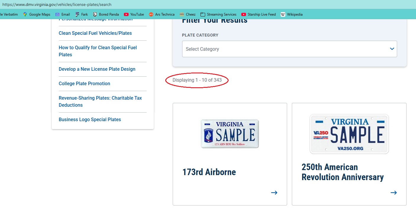
    Heck, we have multiple designs WITHIN each state. Virginia alone has dozens of designs you can get.

    Load More Replies...
    View more comments
    #89

    A Flag Map Of Europe Where Each Country Is Shown With The Flag Of The Nation It Shares Its Shortest Land Border With

    Europe map filled with country flags, showcasing a humorous and bad cartography style for funny maps SEO keyword.

    TerribleMaps Report

    Fat Harry (Oi / You)
    Community Member
    2 months ago Created by potrace 1.15, written by Peter Selinger 2001-2017

    This is just... wrong. Wrong title for the post, maybe.

    Miki
    Community Member
    2 months ago (edited) Created by potrace 1.15, written by Peter Selinger 2001-2017

    If it's a joke, I don't get it. Ukraine with Japan, Poland with Afghanistan. Wtf ;D

    Load More Replies...
    Foxglove🇮🇪
    Community Member
    2 months ago Created by potrace 1.15, written by Peter Selinger 2001-2017

    I can't see any pattern here, Ireland has South Korea, Russia has Jamaica, Uganda is up on Sweden. Makes no sense

    arthbach
    Community Member
    2 months ago Created by potrace 1.15, written by Peter Selinger 2001-2017

    Ireland shares a border with South Korea? Usually it is said to share it's only border with the UK (and vice versa). Germany and Afghanistan? Finland and the USA? Ukraine and Japan?

    Nicole Weymann
    Community Member
    2 months ago Created by potrace 1.15, written by Peter Selinger 2001-2017

    I don't get it. At first I thought the country got the flag of the neighbouring country with the shortest common border - but Denmark and Israel, Germany and Cyprus or Turkey and Argentina (France/Greece, Belgium/India,...) DON'T have a common border. Then I thought "shortest border X equals shortest border Y at blabla km", but Argentina's shortest border (Uruguay) is 590 km - Turkey's border to Azerbaijan is 9 km. Iceland HAS NO land borders - what is the Czech flag doing there?

    For All Pedernity
    Community Member
    2 months ago Created by potrace 1.15, written by Peter Selinger 2001-2017

    Probably an attempt at a joke. Ha ha.

    ADVERTISEMENT