Get Premium
Dark mode theme is available exclusively for premium users. Learn more about the benefits of subscribing.
No fees, cancel anytime.

 Dark Mode Ad-Free Browsing Unlimited Content
 Ad-Free Browsing Unlimited Content Dark Mode
Join 1.2 million Panda readers who get the best art, memes, and fun stories every week!
If an atlas was your favorite ‘book’ as a child and spending time on Google Maps is now a favored pastime, welcome to the best post you’ll see all day. While it is a bold statement to make, any fan of maps ought to love today’s list, as it’s dedicated to all sorts of old and ancient maps.
So, without further ado, scroll down to find some of the most unique examples of cartography that we managed to find on the internet, and enjoy the trip they take you on. While you’re at it, make sure to upvote your favorite maps, too!
Below you will also find Bored Panda’s interview with assistant professor of geography at University of Oregon, an expert in cartography, map design, and mapping environment-society interactions, Carolyn Fish, who was kind enough to answer a few of our questions.
This post may include affiliate links.
Ptolemy's world map designed in 150 AD. For the first time in history, longitudinal and latitudinal lines were added to a world map.
Cartography is usually defined as the science or practice of making maps. But some sources define it as an art form, and it’s not difficult to see why. Looking at this list, it’s evident that maps can be not only useful, but beautiful, too.
Some more elaborate or decorative than others, maps are always shaped by culture and the knowledge of the people who create them, says Carolyn Fish of University of Oregon. In an interview with Bored Panda, she noted that it's the individual worldviews of the map creators that drive what gets put on a map, what gets left off, and how it is designed.
Carolyn Fish continued to point out that maps are a representation of understanding of the world in the time when they were created. “This means that looking at old maps lets us get an idea of what the world looked like at that time,” she said.
“I remember my mom throwing out old maps that had the USSR on them saying ‘oh, they are out of date,’ but really, the borders on those maps, while not representative of the world in the 21st century, were valid for the time in which the map was created.”
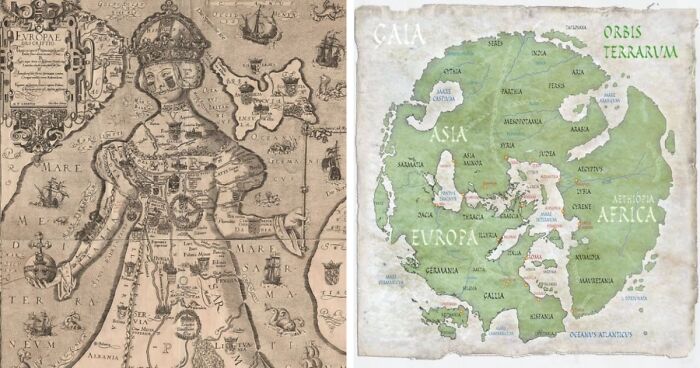
Rotate it 90 deg anticlockwise to get North at the top, then you can see Britain just next to her left shoulder, the arm is Denmark, then there's the Baltic "Sarma" sea, then Russia near her left foot. Her right side is much further out of true though, but shows Italy (and Africa opposite) and the Adriatic coast down to Greece. Interesting anyway, but yes, why?
The animals are the best thing about this one. Especially the bonnacon which can k**l you with a fart
According to Fish, old maps open up the potential for conversations about the past and what information was represented on a map from that time period. “Old maps tell a story of a past place. This is so important for understanding what is happening now and what histories shape a place,” the expert emphasized.
Every German owner of a house either is, was, has, had, will, or will have had to deal with their local land registry offices, known as »Katasteramt«...🏃🏽💨
A great example of how old maps allow us to take a glimpse at what life was like hundreds or thousands of years ago is Imago Mundi – a Babylonian clay tablet, considered to be the oldest known world map, which reportedly dates all the way back to 6th century BCE. According to the World Economic Forum, it provides a unique look into the ancient world and ancient perspectives on earth and the heavens.
In most instances, the description of the holy land was "ours".
Samuel Dunn's map of the world, drawn in 1794 AD. Dunn was the first to map out the entire world using Captain James Cook's discoveries as his guide.
Australia's looking a bit ill, but at least he got New Zealand in there. Though it appears, he may have missed Cook Strait.
Talking about the technologies that made the biggest impact in the world of cartography, Carolyn Fish admitted not being an expert on historical cartography methods, but in her opinion, the invention of Geographic Information Systems (GIS) has had a profound impact on map creation in recent decades.
“That combined with the internet and the ability to share maps and create interactive maps has allowed for those with different training to create maps and do geospatial analysis.”
Remember on the 4th of July, all you USAians, to give heartfelt thanks to your liberators, the French - without whom you would have lost your war of independence, and most people in the modern US would still be speaking French or Spanish or (maybe if they were lucky) their ancestral American languages. If only Mexico hadn't outlawed slavery, Texas never would have revolted and there'd be no question that "the Gulf of Mexico" is obviously just that. Signed, a Brit, quite happy that the French refer to "the English Channel" as "the sleeve" (in French - they would use French, wouldn't they? 🤷)
The Psalter World Map, drawn by an unknown medieval monk in 1260 AD. Maps from this time period usually place the east at the top of the globe, where the sun rises and Jesus watches over the world.
Nowadays, arguably few people rely on good old unfoldable maps to get to their destination. It’s safe to assume that more people than not get around with the help of Google maps. As a matter of fact, in the US, at least, Google maps is the clear winner when it comes to leading mapping apps by downloads (based on data from 2023).
Roman Empire became the most dominant country globally by AD 98–117 through a mixture of military power, political adaptability, and economic enlargement. This enlargement drastically transformed the Mediterranean world.
Nicolaes Visscher produced Orbis Terrarum Nova et Accuratissima Tabula, an etched double hemisphere map, in Amsterdam in 1658. Additionally, it includes scaled-down projections of the north and south poles. The painter Nicolaes Berchem drew four mythical images, one in each corner, to decorate the border, depicting Zeus, Neptune, Persephone, and Demeter. It is a vintage illustration of elaborate Dutch globe maps.
The Bunting Clover Leaf Map, created by Heinrich Bunting in Germany in 1581, is a later Christian map. This map represents the world as an extension of the Christian trinity, with Jerusalem serving as the hub that binds it all together, rather than how it actually is.
before WWI and WWII that area of europe had so many little principalities and kingdoms and then the wars and bam they got combined and and divided and we have the countries that are there now. So many people dont know how intricate it was or even what, who and where this area is and how dang influential in history it was for sooooo many years
Someone's map of what they thought the ancient world looked like drawn centuries later. We still do the same thing today. Kind of surreal realizing that they were doing that 250 years ago too.
Although the old city walls/ramparts no longer exist, you can see the original shape in satellite views today..... Screenshot...6a-png.jpg 
World map by Cosmas Indicopleustes from the sixth century, which shows the globe as a rectangular-shaped surface.
"Cosmas Indicopleustes" basically means "Cosmas who sailed to India" More here: https://en.wikipedia.org/wiki/Cosmas_Indicopleustes

I collect old map images, this totally hit all my buttons this morning and I grabbed every one I didn't already have :-) thanks!
I collect images of old maps (can't afford the real deal) but I have never seen many of these before.
Load More Replies...I was a little disappointed not to see any "T and O" maps. Even so, this was interesting and fun.


 No fees, cancel anytime


")
")