ADVERTISEMENT

I was lucky enough to be born in a time where I’ve never had to use physical maps to get places. And while I do find paper maps to be charming, I have to admit that I’m glad I can rely on Google and a robotic voice with questionable pronunciation to tell me where I need to go while driving. But if you're not behind the wheel, maps can be so much more than simply tools for navigation.

We took a trip to The World in Maps Instagram account and gathered some of their most informative and fascinating posts below. As you scroll through this list, we hope you’ll learn something new about our planet, and perhaps even your own country. Enjoy diving into the wonderful world of maps, and keep reading to find a conversation with the creator of The World in Maps, Xavier Ruiz!

#1

Cats labeled as Argentina and Chile humorously representing informative maps' boundaries.

instagram Report

Tiffany Sauter
Community Member
1 year ago Created by potrace 1.15, written by Peter Selinger 2001-2017

Did somebody put an airplane seat in their house?

View more comments

To learn more about maps and find out how The World in Maps started in the first place, we reached out to the account's creator, Xavier Ruiz, who was kind enough to have a chat with Bored Panda.

"The origins of The World In Maps trace back to 2017 when, after years of being a passive user on X (formerly Twitter), I decided to become more active and build a following," Xavier shared.

"I spent time brainstorming how I could bring something unique to the platform, combining my two main passions: history and international politics, along with my love for maps," the creator explained. "This combination felt like the perfect way to present complex global issues and historical events in an accessible, visual way. Today, the X account (@xruiztru) has over 70k followers."

RELATED:
    #2

    Interesting Fact

    World map showing daylight distribution, illustrating when 99% of the global population receives sunlight.

    instagram Report

    Adz86
    Community Member
    1 year ago Created by potrace 1.15, written by Peter Selinger 2001-2017

    That's right 99% of the world, you're getting Australia's sloppy seconds sunlight.

    View more comments
    ADVERTISEMENT
    #3

    Map of Greenland and Iceland labeled as "The biggest scam in history," highlighting size misconception.

    instagram Report

    Steve Robert
    Community Member
    1 year ago Created by potrace 1.15, written by Peter Selinger 2001-2017

    Yup. You don't want to live here. It's all ice. In fact, we call it Ice Land. You want to go to Green land. Much nicer.

    View more comments

    "In 2021, several friends suggested that the content I was posting on X could be just as successful on Instagram," Xavier continued. "Initially hesitant and not quite comfortable with the platform, I decided to give it a try in June of 2021 when I had more time at work."

    "At first, I kept the Instagram page a secret from family and friends, feeling a bit embarrassed," he admitted. "However, the growth was almost immediate. The page gained momentum quickly, and now we have more than 270k followers. There are some times that we grow more than 3k followers a day!"

    #4

    35 Years After The Fall Of The Wall, Divide Between West And East Berlin Can Still Be Seen From Space Due To Different Lightbulbs Used On Each Side

    Aerial view of illuminated city map at night, showcasing intricate street patterns and glowing urban areas.

    instagram Report

    #5

    Three cats labeled Norway, Sweden, and Finland cuddling humorously, illustrating geography in a unique perspective.

    instagram Report

    ADVERTISEMENT

    And it's no secret to Xavier why his account has become so popular. "The rapid success of The World In Maps is a result of the clear, visual presentation of topics like history and international politics, which resonate with a wide audience," he explained.

    "I believe many people are interested in these subjects, and the visual format makes the content both engaging and easy to understand. Additionally, our ability to post about timely topics and current events has helped us stay relevant, contributing to the page’s ongoing growth."

    #7

    Did You Know That Turkey Borders 8 Countries With 7 Different Alphabets? This Map Shows How Turkey Is A Bridge Between Different Cultures And Civilizations

    Map showing Turkey bordering seven countries with unique alphabets, highlighting geographical diversity.

    instagram Report

    Steve Robert
    Community Member
    1 year ago Created by potrace 1.15, written by Peter Selinger 2001-2017

    And next week, Turkey will border mash potatoes, stuffing, and green bean casserole.

    View more comments
    #8

    A Female Falcon Was Equipped With A Satellite Tracking System In South Africa Before Migrating To Finland

    Map showing a continuous vertical line from Finland to South Africa, highlighting a unique perspective on geography.

    instagram Report

    Tobias Reaper
    Community Member
    1 year ago (edited) Created by potrace 1.15, written by Peter Selinger 2001-2017

    why have they blurred out the country of N i g e r

    View more comments
    ADVERTISEMENT
    ADVERTISEMENT

    When it comes to why maps are so fascinating, Xavier says, "They provide a unique, visual representation of the world, turning complex concepts into something tangible and easy to understand. As both a historian and a fan of international politics, I appreciate how maps offer a way to explore connections between places, events and cultures across time and space. They can tell stories, reveal hidden patterns, and even change the way we perceive the world."

    "What I find particularly captivating is how maps don't just show locations but also embody the power dynamics, histories, and cultural shifts of different regions," the creator added. "Whether it’s a map tracing the reach of ancient empires or a modern political maps illustrating shifting alliances, maps serve as lenses through which we can understand the complexities of the world."

    #10

    All Were Once Part Of The Same Ancient Mountain Range, The Central Pangean Mountains

    Map highlighting Watkins Range, Scandinavian, Appalachian, and Atlas Mountains; informative perspective-changing geography.

    This range formed over 300 million years ago during the Paleozoic Era when the supercontinent Pangaea was assembled. These mountains are now separated by vast distances due to the drifting of tectonic plates over millions of years.

    instagram Report

    Scott Rackley
    Community Member
    1 year ago Created by potrace 1.15, written by Peter Selinger 2001-2017

    The appalachians end in north Georgia, not Florida

    View more comments
    ADVERTISEMENT
    #11

    California Explained

    Map humorously explaining California with regions labeled by stereotypes.

    instagram Report

    Carl Roberts
    Community Member
    1 year ago Created by potrace 1.15, written by Peter Selinger 2001-2017

    This is 100% not true for the northwest corner of the state. No upscale beach communities up there. Just lots of pot & meth

    View more comments
    #12

    What A Shame For Hungary

    Map showing Europe, with Hungary highlighted as having no women in government, illustrating gender representation differences.

    instagram Report

    Jrog
    Community Member
    1 year ago (edited) Created by potrace 1.15, written by Peter Selinger 2001-2017

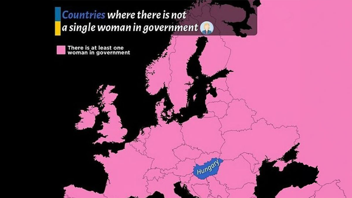
    Hungary should be ousted from the UE, stat. They are clearly siding with Putin's imperialistic plans, leech off EU subsidies (which are often "mishandled" or straight up appropriated by Fidesz's -the governing party- officers) without following their obligations, and openly campaign against the Union's equity, freedom and integration policies. Orban is an authoritarian despot who was kept in power through two very debatable and likely rigged elections. If they don't get their s**t together they have no place in a modern European society.

    View more comments

    Xavier also says maps are dynamic, as they evolve the same way the world does. "Borders shift, populations change and new discoveries unfold and maps constantly reflect these transformations," he noted. "For me, they are a perfect intersection of my interests in history and global affairs, offering endless opportunities for exploration and understanding how the world once was as well as the world we live in."

    #13

    Tiny Bangladesh Has More Population Than Russia

    Map showing population comparison: Russia with 143.9 million and Bangladesh with 165.9 million, highlighting informative data.

    instagram Report

    Steve Robert
    Community Member
    1 year ago Created by potrace 1.15, written by Peter Selinger 2001-2017

    And the Russian population will keep shrinking until the invasion of Ukraine is over with.

    View more comments
    #14

    A World Map Showing Only The Countries That Have Gained Independence From The UK

    Map showing countries that gained independence from the UK, with flags depicting each nation.

    instagram Report

    Glix Drap
    Community Member
    1 year ago Created by potrace 1.15, written by Peter Selinger 2001-2017

    We appear to have got independence from ourselves.

    View more comments
    #15

    The Lion, Once Widely Distributed Across Most Of Africa And Parts Of Europe And Asia, Is Now Confined To A Number Of Isolated Areas

    Map showing historic and present distribution across Africa, Europe, and Asia. Red indicates historic, blue indicates present areas.

    Amounting to only about 20% of its historic range.nn#WorldLionDaynnvia wikipedia

    instagram Report

    So how does Xavier decide which maps to post? "I always consider current relevance. I aim to share maps that are connected to trending topics or global events, helping to explain ongoing situations in a visually engaging way," he told Bored Panda.

    "For example, if a major geopolitical issue is being discussed, I might post a map that clarifies the geographic context or highlights interesting facts about the country or region involved," Xavier explained. "For historical events, I like to mark important anniversaries with the hashtag #OnThisDay, providing maps that shed light on key moments in history."

    ADVERTISEMENT
    #16

    Map Shows The Roots Of The Death March Into The Syrian Desert. Approximately 1.5 Million Armenians Were Systematically Deported, Massacred, Or Marched To Their Deaths By The Ottoman Empire

    Armenian population map showing changes over time in highlighted green areas.

    Armenian Genocide Remembrance Day

    instagram Report

    Corvus
    Community Member
    1 year ago Created by potrace 1.15, written by Peter Selinger 2001-2017

    There are still couintries today (not Turkey itself) that deny this ever happened...

    View more comments
    #17

    For The 32nd Year In A Row, The United Nations Votes Overwhelmingly To End The Us Embargo On Cuba

    World map showing UN vote on ending US embargo; green for in favor, red for against, purple for abstained.

    instagram Report

    #18

    Kiribati Is The Only Country In The World To Straddle All Four Hemispheres

    Map highlighting Ecuador and Kiribati with arrows, emphasizing geographic perspective shift.

    instagram Report

    Steve Robert
    Community Member
    1 year ago Created by potrace 1.15, written by Peter Selinger 2001-2017

    Wait. I thought there were only two hemispheres: North and South.

    View more comments

    We were also curious where these fascinating maps come from. "Sometimes I find maps online that are well-designed and fit the topic at hand, and I always make sure to credit the original source. Other times, I create my own maps, adding a unique perspective or offering more in-depth analysis," Xavier shared. "Other times, I just create maps that are more like memes. When I design my own, I include the World in Maps logo, so it's clear they are original creations. This approach allows me to offer a mix of curated content and custom visuals to keep the page fresh and engaging."

    #19

    The Columbian Exchange

    Map illustrating the Columbian Exchange, showing crops and animals exchanged between the Americas, Europe, Africa, and Asia.

    instagram Report

    Dragons Exist
    Community Member
    1 year ago Created by potrace 1.15, written by Peter Selinger 2001-2017

    That was the Transatlantic Slave Trade, which is different

    Load More Replies...
    Charlie the Cat
    Community Member
    1 year ago Created by potrace 1.15, written by Peter Selinger 2001-2017

    Diseases & rats? I'm sure the Americas didn't want that exchange.

    Andrea Steinacher
    Community Member
    1 year ago Created by potrace 1.15, written by Peter Selinger 2001-2017

    As if there were no weeds that came from the Americas - ragweed, Mahonia, Solidago, pennsylvanian ash, Amaramth, Californian poppy andon and on. Pests: phylloxera, potato beetle. Syphillis

    Ron Man
    Community Member
    1 year ago Created by potrace 1.15, written by Peter Selinger 2001-2017

    Not really all that accurate, but okay it's BP

    Nancy Parker
    Community Member
    1 year ago Created by potrace 1.15, written by Peter Selinger 2001-2017

    Peas, lentils, and garbanzos are also Old World.

    Stephanie Barr
    Community Member
    1 year ago Created by potrace 1.15, written by Peter Selinger 2001-2017

    So, there was no malaria or yellow fever in the Americas? But they were the ones with quinine? Makes me wonder what they used it for.

    John Dilligaf
    Community Member
    1 year ago Created by potrace 1.15, written by Peter Selinger 2001-2017

    I've wondered , occasionally, what the world's history would have been like if there had been a few pandemic style diseases endemic to the Americas that affected the European explorers the same way European diseases affected the American native population.

    Conor
    Community Member
    1 year ago Created by potrace 1.15, written by Peter Selinger 2001-2017

    I thought coffee ...and chocolate... came from the americas

    Laura Gillette
    Community Member
    1 year ago Created by potrace 1.15, written by Peter Selinger 2001-2017

    There weren't any RATS in the americas before colonization?? I find that hard to believe. Must've been only certain species of rats that got introduced, and possibly/probably caused extinction of native rats.

    Andrea Steinacher
    Community Member
    1 year ago Created by potrace 1.15, written by Peter Selinger 2001-2017

    https://en.wikipedia.org/wiki/New_World_rats_and_mice

    Load More Replies...
    Evagating Beewolf (she/they)
    Community Member
    1 year ago Created by potrace 1.15, written by Peter Selinger 2001-2017

    for what it's worth I believe that in the entomology community your standard honeybee is considered an invasive species in the Americas, as is tumbleweed (it's native to Russia).

    Camilla Koutsos
    Community Member
    1 year ago Created by potrace 1.15, written by Peter Selinger 2001-2017

    I love that diseases and pests are included.

    Arenite
    Community Member
    1 year ago Created by potrace 1.15, written by Peter Selinger 2001-2017

    Don’t forget that the Americas also sent cocaine and syphilis back to Europe

    Niels AirMax
    Community Member
    1 year ago

    This comment has been deleted.

    Tiger
    Community Member
    1 year ago Created by potrace 1.15, written by Peter Selinger 2001-2017

    I didn’t realize that honey bees weren’t native to the americas. (We had other pollinating bees but not honeybees until the 1700s, crazy!)

    BrunoVI
    Community Member
    1 year ago

    This comment is hidden. Click here to view.

    You'd think from reading the internet that Europeans murdered most American Indians, but about 90-something percent of the population loss was from smallpox and other epidemics.

    Brittania Kelli
    Community Member
    1 year ago Created by potrace 1.15, written by Peter Selinger 2001-2017

    That's literally why we say we murdered them, because we infected them.

    Load More Replies...
    View more comments
    #20

    Map Compares North American Climatic Zones To Eurasian Regions

    Color-coded map of North America with country names from other continents for perspective-changing insight.

    instagram Report

    Tiger
    Community Member
    1 year ago Created by potrace 1.15, written by Peter Selinger 2001-2017

    This actually puts a lot of things into perspective for me as a North American, cool!

    View more comments
    #21

    A Lovely Overview Of The Approximate Limits Of The World Known To The Romans, Around 150 Ad

    Map showcasing historical trade routes across Asia and Europe, highlighting terrain features.

    instagram Report

    David
    Community Member
    1 year ago Created by potrace 1.15, written by Peter Selinger 2001-2017

    The Romans were ware of China, and China was aware of them, just no direct contact, though Roman coins have been found as far away as Korea. Also huge parts of Russia, the Romans knew Scythia, and the ancient greeks knew of Islands to the West of Ireland, which we know at least one is Iceland, so the Romans knew about it too.

    View more comments

    Finally, we wanted to know if Xavier was partial to any of the maps he's ever shared. "One of my favorite maps that I’ve created is one showing the population density of the 'tiny' island of Java in Indonesia compared to the rest of the world," he noted.

    "It’s truly fascinating how densely populated Java is—despite being just one island, it’s home to more people than many entire countries! This map is especially striking because it highlights the stark contrast between Java and other nations, making the scale of its population size even more surprising," the creator said. "The fact that Java is one of the most populous islands in the world, but still relatively small in geographical size, makes this map both eye-opening and thought-provoking."

    #22

    Dutch Women Are The Tallest Women In, Not Only Europe, But In The Whole World!

    Map showing average female height in European countries, highlighting tallest in Netherlands at 170.4 cm.

    They are followed by Montenegrin and Danish women

    instagram Report

    VeryDarkMatter
    Community Member
    1 year ago (edited) Created by potrace 1.15, written by Peter Selinger 2001-2017

    Floor Jansen proves this map right ;)

    View more comments
    #23

    Timeline of countries legalizing same-s*x marriage from 2001 to 2023, ending with Greece's legalization in 2023.

    instagram Report

    Kelly Scott
    Community Member
    1 year ago Created by potrace 1.15, written by Peter Selinger 2001-2017

    I'm sure with the orange monkey in office, the US will now go backwards on this as well.

    View more comments
    #24

    Map of Cyprus rotated 162 degrees to fit perfectly on the Sea of Marmara, Turkey.

    instagram Report

    We hope you're enjoying this list of informative and entertaining maps, pandas! Keep upvoting all of your favorites, and let us know in the comments below what kind of map you'd like to see featured on The World in Maps next. Then, if you'd like to check out even more maps that might teach you something new about our planet, look no further than right here!

    #25

    87% Of The World Lives In The Northern Hemisphere, And Only 13% Of The World Lives In The Southern Hemisphere

    World map showing 87% of land north and 13% south of the equator, highlighting perspective on global land distribution.

    instagram Report

    Steve Robert
    Community Member
    1 year ago Created by potrace 1.15, written by Peter Selinger 2001-2017

    That's because the earth is flat, and all the Chinese fell off.

    View more comments
    #26

    What If Canada And Mexico Split The United States Between Them?

    Informative map showing countries of North America with flags of Canada, USA, and Mexico.

    instagram Report

    #27

    The Land Between Iceland And Ireland

    Map showing a line from Iceland to Ireland with humorous name variations, highlighting informative geographic perspectives.

    instagram Report

    Stef
    Community Member
    1 year ago Created by potrace 1.15, written by Peter Selinger 2001-2017

    Took my stupid a** 5 minutes to realize it's just an alphabet jokel, and there aren't little islands running between Iceland and Ireland.

    View more comments
    #28

    Denmark?!

    Map showing variations in saying "92" across Europe, highlighting linguistic differences in colorful regions.

    instagram Report

    Multa Nocte
    Community Member
    1 year ago Created by potrace 1.15, written by Peter Selinger 2001-2017

    Yeah, we know - we are weird. Quatre-vingt douze.

    View more comments
    #29

    The Amount Of Sugar In Your Fanta Varies Widely Across Europe

    Map showing sugar content in Fanta across Europe, highlighting varying levels from less than 5g to more than 10g per 100ml.

    instagram Report

    Viking Panda
    Community Member
    1 year ago Created by potrace 1.15, written by Peter Selinger 2001-2017

    If this is correct, that explain why I think the Fanta in Spain is much better then in Norway!

    View more comments
    #30

    Which Countries Actually Speak English The Best As A Second Language?

    Map showing English proficiency index in European countries, highlighting non-native English speakers in 2023.

    instagram Report

    Corvus
    Community Member
    1 year ago Created by potrace 1.15, written by Peter Selinger 2001-2017

    I single-handedly raised Bulgaria's index by posting comments on Bored Panda :P

    View more comments
    #31

    Civilization vs. Barbarism

    Map showing olive oil vs butter consumption in Europe with olive and butter regions highlighted.

    instagram Report

    #32

    Several Countries Around The World Have No Rivers

    Map showing countries without rivers, highlighting regions in red, changing perspective on geographical features.

    instagram Report

    HF
    Community Member
    1 year ago Created by potrace 1.15, written by Peter Selinger 2001-2017

    That means they will be chasing waterfalls, since they can't stick to the rivers and the lakes that they're used to

    View more comments
    #33

    This Map Showing The Most Valuable Italian Brands Starkly Highlights The Divide Between Italy’s North And South

    Map of Italy displaying logos of famous brands, showcasing regional origins, changing perspective on geography and industry.

    instagram Report

    Jrog
    Community Member
    1 year ago Created by potrace 1.15, written by Peter Selinger 2001-2017

    Several of those brands have a roots in the late XIX century, where the North was remarkably industrial and the south was mostly agricultural. Others are industrial companies that started in the early XX century, benefiting from the growing rail and road connections with Central Europe, while the South was lagging behind in infrastructure investment.

    View more comments
    #34

    Subway Line Comparision: Rio De Janeiro 🇧🇷 vs. Shanghai 🇨🇳

    "Comparison of Rio de Janeiro and Shanghai metro maps from 1993 to 2013, showing infrastructure development."

    instagram Report

    #35

    Map showing drive distances from Rome, highlighting regions reachable within various hours, changing travel perspective.

    instagram Report

    Paul C.
    Community Member
    1 year ago Created by potrace 1.15, written by Peter Selinger 2001-2017

    This is clearly wrong because, as we all know, all roads lead to Rome! Boom, Boom, I'm here all week.

    View more comments
    #36

    This Is A Really Cool Ottoman Map Of Australia From The Year 1803

    Antique map of Australia with Arabic script, showcasing historical cartography insights.

    instagram Report

    #37

    Until This Heatwave... Sweden 🇸🇪 And Norway 🇳🇴 Had Never Hit > 30 °c

    Map showing high September 2024 air temperatures in Norway, Sweden, and Finland, highlighting climate changes.

    instagram Report

    Corvus
    Community Member
    1 year ago Created by potrace 1.15, written by Peter Selinger 2001-2017

    Not trying to scare you, but... it will keep getting worse. Especially with the Orange Blob back in office.

    View more comments
    #38

    What's Your Favorite One?

    Aerial views of San Francisco, Tokyo, Thessaloniki, Sydney, Paris, Lagos, Florence, Mexico City, Dubai, Barcelona, Bourtange, Venice.

    instagram Report

    #39

    A Powerful And Prolonged Heatwave Is Affecting Eastern Europe And The Balkans

    Map showing maximum temperature anomalies in Europe from July 12 to 19, 2024, highlighting climate variations.

    instagram Report

    Steve Robert
    Community Member
    1 year ago Created by potrace 1.15, written by Peter Selinger 2001-2017

    And imagine how much worse it would be if global warming was real.

    View more comments
    #40

    Map Shows The Percentage Of Population Able To Hold A Conversation In English In Each European Country

    Map of Europe showing English conversation ability by percentage, with UK at 95% and Hungary at 20%.

    instagram Report

    PeTeH
    Community Member
    1 year ago Created by potrace 1.15, written by Peter Selinger 2001-2017

    Finland shows no data, because we don't hold conversations. At all.

    View more comments
    #41

    Percentage Of Indigenous In The Americas By Country/Region

    Map of South America showing indigenous population percentages by country, revealing diverse demographic data.

    instagram Report

    BrunoVI
    Community Member
    1 year ago Created by potrace 1.15, written by Peter Selinger 2001-2017

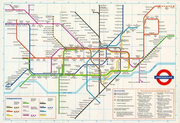
    For comparison: The U.S. has 3.3 million (or 1% ) people who identify solely as American Indian (the term preferred by most American Indians) and 8.8 million who identify as mixed-race including American Indian. A much larger portion of white Americans have at least one American Indian ancestor.

    View more comments
    #42

    Map Shows What % Of South American Countries’ Population Resides In The Capital

    Map showing population percentages living in capitals across South America, highlighting varied urban concentrations.

    instagram Report

    arthbach
    Community Member
    1 year ago Created by potrace 1.15, written by Peter Selinger 2001-2017

    It's 100% for Vatican City, Monaco and Singapore. Aside from micronations/city states, Kuwait is probably the country with the largest population living it the capital, 70.3% and in Europe, Iceland has the largest percentage of population in the capital, 36.0%, followed by Estonia and Latvia.

    View more comments
    #43

    The “”blue Banana”” Is A Term Used To Describe Europe’s Most Densely Populated And Industrialized Belt

    Map highlighting a blue zone covering parts of Europe, illustrating an informative perspective on geographical regions.

    instagram Report

    #45

    In Case You Were Wondering Why More Firms Are Setting Up Camp In Poland After Leaving Germany

    Map showing average salaries across Europe in 2023, highlighting differences in hourly wages between countries.

    instagram Report

    BrunoVI
    Community Member
    1 year ago

    This comment is hidden. Click here to view.

    I presume by "salary," OP means "wage." In the U.S., "salaries" are used chiefly in managerial and teaching roles and specifically mean that the recipient is not paid by the hour. Hourly pay is called "wage."

    View more comments
    #46

    Iranian Diaspora ; Countries With The Highest Population

    Map showing Iranian diaspora in countries with the highest populations, featuring the USA, Canada, and Germany prominently.

    instagram Report

    #47

    50 Most Valuable Companies On The Continent. Visual By The European Correspondent

    Map showing Europe's top 50 valuable companies, highlighting countries and market capitalizations.

    instagram Report

    Roland Nijveld
    Community Member
    1 year ago Created by potrace 1.15, written by Peter Selinger 2001-2017

    Just because their headquarters is in the Netherlands, that doesn't make Stellaris Dutch (Fiat-Chrysler and Peugeot-Citroën) Same goes for Prosus, wich is South African. Not to mention that Linde is German and not from the UK

    View more comments
    #48

    With A Stunning Victory, Spain Extends The Streak To 6 Consecutive Southern Euro Cup Winners!

    Map highlighting six consecutive southern Euro Cup winners in red.

    instagram Report

    #49

    Irish Diaspora | Countries With The Highest Population

    Map showing countries with the highest Irish diaspora populations, including the USA, UK, Canada, and Australia.

    instagram Report

    Altea
    Community Member
    1 year ago Created by potrace 1.15, written by Peter Selinger 2001-2017

    does this mean of Irish descent? 33 million is way too much

    View more comments
    #50

    Map Shows The Largest Foreign Community In Each Country Across The Americas

    Map Shows The Largest Foreign Community In Each Country Across The Americas

    instagram Report

    Tiger
    Community Member
    1 year ago Created by potrace 1.15, written by Peter Selinger 2001-2017

    The Indian immigrants who run the restaurant in the building I work in barely speak English but are so friendly and sweet. They gave me free food today - it’s garlic naan and a dish with some kind of yellow gravy and spices that tastes almost a little sweet like apples but also has chicken and potatoes in it. It’s SO GOOD, I’m eating it right now. I love living in a multicultural country, we can all enjoy the best of each other’s culture and heritage (and food!)

    #51

    Where Do European Tourists Go?there Is A Clear Favourite Destination For Europeans: Spain

    Where Do European Tourists Go?there Is A Clear Favourite Destination For Europeans: Spain

    instagram Report

    Remi (He/Him)
    Community Member
    1 year ago Created by potrace 1.15, written by Peter Selinger 2001-2017

    This map must be a few years old, because the Estonian answer of Russia 😵‍💫

    View more comments
    See Also on Bored Panda
    #52

    Fun Fact: The Nile River Valley And Vietnam Have A Very Similar Shape

    Fun Fact: The Nile River Valley And Vietnam Have A Very Similar Shape

    instagram Report

    Tiger
    Community Member
    1 year ago Created by potrace 1.15, written by Peter Selinger 2001-2017

    I have a map above my bed. I was thinking last night that it’s kinda cute that Australia, India and the continent of Africa all have a cute little island buddy to the southwest (Tasmania, Sri Lanka and Madagascar).

    View more comments
    #53

    Areas That Have Had Muslim Rulers Any Time In History

    Areas That Have Had Muslim Rulers Any Time In History

    instagram Report

    Andrea Steinacher
    Community Member
    1 year ago Created by potrace 1.15, written by Peter Selinger 2001-2017

    The Moors never ruled that much of France, they only conquered thesmll part between Barcelona and Genua - look up Septimania https://en.wikipedia.org/wiki/Septimania

    View more comments
    #54

    Map Shows The Vegetation Or Biomeme Analogues Of Australia

    Map Shows The Vegetation Or Biomeme Analogues Of Australia

    instagram Report

    #55

    Map Shows Which Countries Use Which Alphabet In Europe

    Map Shows Which Countries Use Which Alphabet In Europe

    instagram Report

    Tiger
    Community Member
    1 year ago Created by potrace 1.15, written by Peter Selinger 2001-2017

    I taught myself Cyrillic because I think it’s so beautiful. I may not be able to understand what the words are saying but I can tell you what the words sound like 😅 (Слава Україні!!!)

    #56

    Gran Colombia (1819-1830), A Short-Lived Republic Established By Simu00f3n Bolu00edvar In 1819

    Gran Colombia (1819-1830), A Short-Lived Republic Established By Simu00f3n Bolu00edvar In 1819

    instagram Report

    Corvus
    Community Member
    1 year ago Created by potrace 1.15, written by Peter Selinger 2001-2017

    Ah yes, Simu00f3n Bolu00edvar, one of my favorite historical personalities :P

    View more comments
    #57

    This Map Divides Europe Into Regions Of Equal Gdp - With The Exception Of Germany, Which Remains Largely Unchanged.

    This Map Divides Europe Into Regions Of Equal Gdp - With The Exception Of Germany, Which Remains Largely Unchanged.

    instagram Report

    #58

    This Map Overlays Europe (Minus Russia) On Australia

    This Map Overlays Europe (Minus Russia) On Australia

    instagram Report

    Captive
    Community Member
    1 year ago Created by potrace 1.15, written by Peter Selinger 2001-2017

    Europe minus Russia? Russia isn't in Europe?

    View more comments
    #59

    How The Next Three Solar Eclipses Will Be Seen From Spain

    Map showing total eclipse paths in Spain for 2026, 2027, and an annular eclipse in 2028 with specific locations and times.

    instagram Report

    Tiger
    Community Member
    1 year ago Created by potrace 1.15, written by Peter Selinger 2001-2017

    Google taught me that Lunes is Monday and Miércoles is Wednesday. (I should have known, being Canadian - we were all taught Lundi and Mercredi in French class!)

    View more comments
    #60

    instagram Report

    Fahd Fattoumy
    Community Member
    1 year ago Created by potrace 1.15, written by Peter Selinger 2001-2017

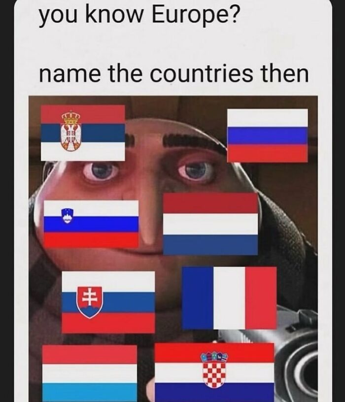
    Serbia, Russia, Slovenia, Netherlands, Slovakia, France, Luxembourg, Croatia

    View more comments
    #61

    Citizenship By Land vs. Blood

    Citizenship By Land vs. Blood

    instagram Report

    Spencer's slave no longer
    Community Member
    1 year ago Created by potrace 1.15, written by Peter Selinger 2001-2017

    Looks like New Zealand is off traveling again and nobody told us.

    View more comments
    See Also on Bored Panda
    #62

    Map Shows All Known Battles In Human History

    Map Shows All Known Battles In Human History

    instagram Report

    Scott Rackley
    Community Member
    1 year ago Created by potrace 1.15, written by Peter Selinger 2001-2017

    Ok, I need a Aussie to tell me what went down in Perth

    View more comments
    #63

    The Island Of Java In Indonesia 🇮🇩 Is More Populated Than Russia 🇷🇺

    The Island Of Java In Indonesia 🇮🇩 Is More Populated Than Russia 🇷🇺

    instagram Report

    Carl Roberts
    Community Member
    1 year ago Created by potrace 1.15, written by Peter Selinger 2001-2017

    Well...most of Russia IS a giant frozen wasteland

    View more comments
    #64

    🇮🇹 The Word For Italy In Various European Languages

    🇮🇹 The Word For Italy In Various European Languages

    instagram Report

    Auntriarch
    Community Member
    1 year ago Created by potrace 1.15, written by Peter Selinger 2001-2017

    So is that cognate with Welsh, meaning foreigners or "not us"

    View more comments
    #65

    instagram Report

    Onan Hag All
    Community Member
    1 year ago Created by potrace 1.15, written by Peter Selinger 2001-2017

    “No one ever went broke underestimating the intelligence of the American public.”

    View more comments
    #66

    We Really Love These Size Comparisons. This Map Compares Pakistan With The East Coast Of USA

    We Really Love These Size Comparisons. This Map Compares Pakistan With The East Coast Of USA

    instagram Report

    BrunoVI
    Community Member
    1 year ago Created by potrace 1.15, written by Peter Selinger 2001-2017

    I notice Lahore is on the Jersey shore.

    View more comments
    #67

    Iran Possesses The Largest And Most Diverse Missile Arsenal In The Middle East

    Iran Possesses The Largest And Most Diverse Missile Arsenal In The Middle East

    instagram Report

    #68

    No Title

    No Title

    instagram Report

    TotallyNOTAFox
    Community Member
    1 year ago (edited) Created by potrace 1.15, written by Peter Selinger 2001-2017

    Depending on where history class is taking place, we in Germany learned a lot about Egypt as well

    View more comments
    #69

    Millions Of Years Ago, Africa And South America Were Like Two Pieces Of A Giant Puzzle, Joined Together In A Supercontinent Called Pangaea

    Millions Of Years Ago, Africa And South America Were Like Two Pieces Of A Giant Puzzle, Joined Together In A Supercontinent Called Pangaea

    Over time, tectonic forces slowly pulled them apart, creating the Atlantic Ocean and shaping the continents we know today.

    instagram Report

    HF
    Community Member
    1 year ago Created by potrace 1.15, written by Peter Selinger 2001-2017

    so Africa used to be the big spoon?

    View more comments
    #70

    What’s The Nearest Country To Your Position In The Us?

    What’s The Nearest Country To Your Position In The Us?

    instagram Report

    Thomas Gauthier
    Community Member
    1 year ago Created by potrace 1.15, written by Peter Selinger 2001-2017

    The only correct answer for all of these is the United States of America... But this is a nice map of the 2nd closest country!

    #71

    How Different European Countries Pronounce The X In Mexico

    How Different European Countries Pronounce The X In Mexico

    instagram Report

    Tiger
    Community Member
    1 year ago Created by potrace 1.15, written by Peter Selinger 2001-2017

    Oh is the original Nahuatl “Meshiko?” Interesting!!

    View more comments
    See Also on Bored Panda
    #72

    Asia Is Divided Into Six Regions

    Asia Is Divided Into Six Regions

    instagram Report

    Bill
    Community Member
    Premium
    1 year ago Created by potrace 1.15, written by Peter Selinger 2001-2017

    God created war so that Americans would learn geography. Mark Twain

    View more comments
    #73

    The Triple Frontier: The Tri-Border Region Where The Borders Of 3 Countries Meet: Argentina, Paraguay And Brazil

    The Triple Frontier: The Tri-Border Region Where The Borders Of 3 Countries Meet: Argentina, Paraguay And Brazil

    instagram Report

    #74

    Most Common Immigrant In Germany

    Most Common Immigrant In Germany

    instagram Report

    Jesse
    Community Member
    1 year ago Created by potrace 1.15, written by Peter Selinger 2001-2017

    Didn't know about the Portuguese and American pockets in Saarland and Rhineland-Palatinate. The Dutch one I get though, because of the border.

    #75

    A Person Made By European Countries ✨

    A Person Made By European Countries ✨

    instagram Report

    BrunoVI
    Community Member
    1 year ago Created by potrace 1.15, written by Peter Selinger 2001-2017

    Who plays soccer wearing one high-heel boot?

    View more comments
    #76

    Map Shows The Areas The Ambitions Terrorist Organization Isis (Islamic State Of Iraq And Syria) Aspired To Control By 2020

    Map Shows The Areas The Ambitions Terrorist Organization Isis (Islamic State Of Iraq And Syria) Aspired To Control By 2020

    instagram Report

    #77

    Map Shows The Top 4 Longest National Borders: America 🇺🇸 - Canada 🇨🇦 Russia 🇷🇺 - Kazakhstan 🇰🇿 Chile 🇨🇱 - Argentina 🇦🇷 China 🇨🇳 - Mongolia 🇲🇳

    Map Shows The Top 4 Longest National Borders: America 🇺🇸 - Canada 🇨🇦 Russia 🇷🇺 - Kazakhstan 🇰🇿 Chile 🇨🇱 - Argentina 🇦🇷 China 🇨🇳 - Mongolia 🇲🇳

    instagram Report

    #78

    Italians In Europe

    Italians In Europe

    instagram Report

    #79

    Map Shows Where You Can Find Tennis Courts In Europe

    Map Shows Where You Can Find Tennis Courts In Europe

    instagram Report

    Kat
    Community Member
    1 year ago Created by potrace 1.15, written by Peter Selinger 2001-2017

    Now search for padel courses ... They are a real pest

    #80

    “Awesome Meme Dude” Map Through Western Europe

    “Awesome Meme Dude” Map Through Western Europe

    instagram Report

    BrunoVI
    Community Member
    1 year ago (edited) Created by potrace 1.15, written by Peter Selinger 2001-2017

    ? EDIT: Nevermind, I get it: Au-Somme-Meme-Dudde.)

    View more comments
    #81

    Write Your Opinion In Comments

    Write Your Opinion In Comments

    instagram Report

    Judes
    Community Member
    1 year ago Created by potrace 1.15, written by Peter Selinger 2001-2017

    In Belgium, are you allowed to say Dutch instead of Flemish?

    View more comments
    See Also on Bored Panda
    #82

    Propaganda Poster, “Portugal Is Not A Small Country,” Showing The Size Of Portugal And The Portuguese Colonial Possessions Compared To The U.S. (1951)

    Propaganda Poster, “Portugal Is Not A Small Country,” Showing The Size Of Portugal And The Portuguese Colonial Possessions Compared To The U.S. (1951)

    instagram Report

    #83

    Map Above Shows Just How Successful Chengdu, China Has Been At Growing Their Metro System

    Map Above Shows Just How Successful Chengdu, China Has Been At Growing Their Metro System

    instagram Report

    Corvus
    Community Member
    1 year ago Created by potrace 1.15, written by Peter Selinger 2001-2017

    Perhaps Toronto didn't need to expand much? The comparison is a bit manipulative.

    #84

    Which Countries Pollute The Most Ocean Plastic Waste?

    Which Countries Pollute The Most Ocean Plastic Waste?

    instagram Report

    Pernille
    Community Member
    1 year ago Created by potrace 1.15, written by Peter Selinger 2001-2017

    Mostly because USA and Europe export their plastic waste to Malaysia, India, and the Philippines.

    View more comments
    #85

    California: 2020 vs. 2024

    California: 2020 vs. 2024

    instagram Report

    Moxitron Jazz
    Community Member
    1 year ago Created by potrace 1.15, written by Peter Selinger 2001-2017

    based on a previous map, meth can really f**k the mind up...

    View more comments
    #87

    The Netherlands Is The 30th Most Densely Populated Country Or Territory In The World And The Densest Country In Europe

    The Netherlands Is The 30th Most Densely Populated Country Or Territory In The World And The Densest Country In Europe

    instagram Report

    BrunoVI
    Community Member
    1 year ago (edited) Created by potrace 1.15, written by Peter Selinger 2001-2017

    Why Brits and many Americans call the Netherlands, "Holland": The "Netherlands" used to be a region of the Holy Roman Empire that included Belgium, Luxembourg, the modern Netherlands, Frisia, etc. "Holland" was used to identify those Netherlands politically aligned with Holland, as opposed to Brabant (roughly Belgium), Bremen, etc.

    View more comments
    #88

    Children Deserve A Childhood Filled With Joy And Rest, Not Early Mornings That Force Them Out Of Bed

    Children Deserve A Childhood Filled With Joy And Rest, Not Early Mornings That Force Them Out Of Bed

    instagram Report

    Tiger
    Community Member
    1 year ago Created by potrace 1.15, written by Peter Selinger 2001-2017

    Countries that have later start times tend to have better school performance too. Forcing kids to wake up way too early because you think anything else is “lazy” is harmful to their development. Studies have been done on this. I’m sure some people would call that “woke” and “radical evil liberalism” though 😂

    View more comments
    #89

    On January 1, 1999, The Euro Was Introduced As A Virtual Currency,it Officially Entered Circulation On January 1, 2002

    On January 1, 1999, The Euro Was Introduced As A Virtual Currency,it Officially Entered Circulation On January 1, 2002

    instagram Report

    Pernille
    Community Member
    1 year ago Created by potrace 1.15, written by Peter Selinger 2001-2017

    That seems wrong, Danmark is not a pre-member, we voted not to join the euro, just like Sweden, ant the UK back when they were still a member.

    View more comments
    #90

    Map Shows Which States Require Front And Rear License Plates vs. Those That Only Require Rear License Plates

    Map Shows Which States Require Front And Rear License Plates vs. Those That Only Require Rear License Plates

    instagram Report

    Tiger
    Community Member
    1 year ago Created by potrace 1.15, written by Peter Selinger 2001-2017

    I never understood not requiring front license plates. Haven’t the police there missed identifying some criminals because they only have one plate on one side?

    View more comments
    #91

    Luxembourg Is Not A Microstate!

    Luxembourg Is Not A Microstate!

    instagram Report

    See Also on Bored Panda
    #92

    United States Of America Partition Plan: Splitting America Into Two Nations, Based On Election Results Maps From The Past 12 Years, And Along County Lines

    United States Of America Partition Plan: Splitting America Into Two Nations, Based On Election Results Maps From The Past 12 Years, And Along County Lines

    instagram Report

    Steve Robert
    Community Member
    1 year ago Created by potrace 1.15, written by Peter Selinger 2001-2017

    California, Oregon, and Washington, are going to form their own country. We will call it Calibunga.

    View more comments
    #93

    Us/Canada Time Zones If They Were Not Adjusted For Political Boundaries

    Us/Canada Time Zones If They Were Not Adjusted For Political Boundaries

    instagram Report

    BrunoVI
    Community Member
    1 year ago Created by potrace 1.15, written by Peter Selinger 2001-2017

    Note that adjacent Alaskan islands (Aleutians) are 23 hours apart.

    #94

    instagram Report

    George Adam
    Community Member
    1 year ago Created by potrace 1.15, written by Peter Selinger 2001-2017

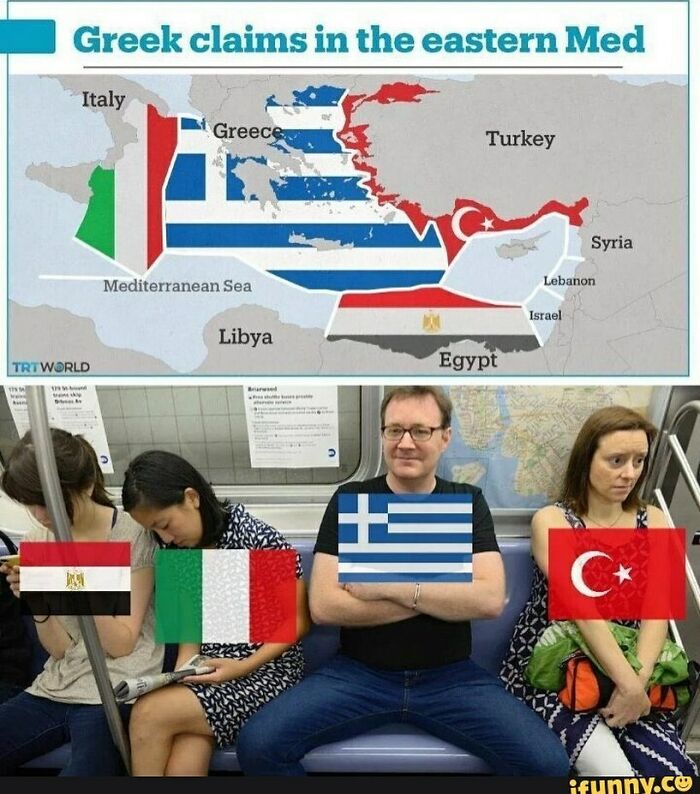
    Actually the map has some mistakes showing Grrek isles as Turkish. Other than that this map is pretty close to maritime law. The uni of Madrid published something very similar...

    #95

    Write Your Opinion In Comments

    Write Your Opinion In Comments

    instagram Report

    #96

    Europe Split Into 4 Regions

    Europe Split Into 4 Regions

    instagram Report

    Tiger
    Community Member
    1 year ago Created by potrace 1.15, written by Peter Selinger 2001-2017

    This map isn’t completely accurate, but shout out to my fellow pandas with Slavic ancestry 🇺🇦❤️

    View more comments
    #97

    America, Still Undefeated

    America, Still Undefeated

    instagram Report

    Donkey boi
    Community Member
    1 year ago Created by potrace 1.15, written by Peter Selinger 2001-2017

    Well obviously! Their portion sizes are bigger so they need bigger bowls!

    View more comments
    #98

    The European Union’s Livestock Population

    The European Union’s Livestock Population

    instagram Report

    #99

    The Roman Empire Was A Multicultural, Multiracial And Multi-Linguistic Success

    The Roman Empire Was A Multicultural, Multiracial And Multi-Linguistic Success

    A bewilderingly diverse number of peoples, from primitive Britons to sophisticated Greeks and Egyptians, accepted a uniform and well-understood set of Roman values and belief systems. There had never been an empire like it, and there has not been one since

    instagram Report

    XenoMurph
    Community Member
    1 year ago Created by potrace 1.15, written by Peter Selinger 2001-2017

    What rubbish. There were constant wars. You don't have a war without underlying resentment. If you bought Roman citizenship you were accepted, everyone else was an underclass. Also Slavery.

    View more comments
    #100

    Personal Income Tax Rate In Europe

    Personal Income Tax Rate In Europe

    instagram Report

    Secret Squirrel
    Community Member
    1 year ago (edited) Created by potrace 1.15, written by Peter Selinger 2001-2017

    This isn't accurate tax rate depends on how much, and you only pay the highest band on the part of your income that's well over the average. This shows the tax rate on some of the earnings of the people rich enough to hit the tax bracket, but not rich enough to lobby governments or out their money off shore. This is not what average people pay.

    View more comments