You can look at the world from a lot of different perspectives, and maps are excellent tools that reflect this diversity of viewpoints.
Each cartographer chooses the story they want to tell, highlighting elements of geography, history, economy, and other areas to paint their own version of our planet.
Maybe it details countries and their borders, maybe it shows the spread of religions, or maybe it reveals the most popular soda drink in every region.
The social media project 'Terrible Maps' shares a whimsical and sometimes absurd approach to mapmaking, and it's full of funny takes you don't normally see in geography textbooks. Continue scrolling to see our hand-picked favorites!
More info: Book | Facebook | Instagram | X
This post may include affiliate links.
Detailed Doggo Map
Misnamed posts again, it's BEST maps not terrible maps. This one is incredibly useful honestly bp
A Map Of Ancient Grease
A Map Of Europe Drawn From Memory
Oklahoma If It Was Used To Express Feelings
I don't know if it is still the case, but the state motto on the Oklahoma license plates used to be "Oklahoma is OK," because they couldn't spell "mediocre."
The motto was changed to “Labor Omnia Vincit”, meaning “labor conquers all things” in Latin.
Load More Replies...I always thought that Oklahoma looked like a hand with a finger pointing
A World Map Centered On Antarctica
For all we know this could be the top of the world, there is nothing to say that the Arctic is the top. It's just something we decided on.
Shows how much maps are stretched, it's most obvious on Africa and South America
I never realized New Zealand was in that position, southeast of Australia. I always thought it was a bit further north.
Australia vs. Austria, Just For Clarity
It makes since that Australia would be orange because of the outback, so im guessing Austria?
Load More Replies...This reminds me of a shirt I saw in Vienna: There are no kangaroos in Austria.
Reminds me of the time the organisers of the G-20 meeting once confused Australia and Austria, so they had a doll representing our then Prime Minister, Julia Gillard, dressed in a dirndl
Ohhh so Austria’s just the part of Australia where they keep the kangaroos? Got it!
Most of us have probably seen the bicycle stamped "Made in Austria Mozart Not Kangaroos"
How Long Is Chile
According to Wikipedia "Chile stretches over 4,300 km (2,670 mi) north to south" According to https://www.converttobananas.com/ 4300km equates to 24,157,303.370787 bananas. You're welcome.
Wow didn't know such a website existed! You made my day, well actually my night since I should be sleeping rn
Load More Replies...Why put Ireland upside down? and Belgium.... I don't even know what way is up?
They put the longer side of each country to adjust them to the size of Chile.
Load More Replies...Do one for the width (like compare with the LA strip connecting Downtown to San Pedro Screenshot...bda138.png
So apparently South Americans will use anything but the metric system too?
Foutland
Being A Bad Neighbour
The reason why the border is shaped that way is the path of a river. That’s exactly the same reason why the power plant was built in this place (cooling water needed). And this nuclear power plant produces electricity for Belgium (and Luxembourg, and Germany). I guess you’d have to be an ignorant idiot to call that being a crappy neighbour.
I still think that Godzilla is incredibly based because he could have gone to any nuclear plant in the world but he chose to destroy France to get his food
Yolklahoma
First to comment! Okies can be rly creative; they have a lot of cool landmarks and events, but people still see us as the flyover state they once were 😔
It's the people we're flying over, not because of the land:)
Load More Replies...Fatalities From Texting And Driving In 1960
Weirdly, these stats *exactly* match those for texting and driving fatalities in 1860!
Texting and driving in 1960 would have required a 50 pound typewriter, hard to fit that in front of the steering wheel.
As An Austrian: So Good
A Map Of The Earth After A Sea Level Rise Of 480m... Just Because
Easy pal. We have boats...how long can you tread water ;)
Load More Replies...65m max : https://www.nationalgeographic.fr/environnement/voici-quoi-ressemblerait-le-monde-si-la-glace-continentale-venait-fondre (. in french but the maps are better :)
Yeah, that's what bothered me about the movie Waterworld. There isn't enough water on the planet to sink that much land.
Load More Replies...Australia.. Explained To Americans
I get Melbourne being NY-ish & Sydney-Brisbane as California. But how is Canberra similar to Jersey?
Jersey is full of suburban planned towns and Canberra is a suburban planned town.
Load More Replies...I object to Ohio being called boring. Wait, never mind.
Not sure how QLD gets Alabama. Half the state is practically desert, a sizeable chunk is basically tropical rainforest and a lot of the south is more like temperate forest.
So half of the rest of the US doesn't believe in Oregon and the rest think people from there have got two heads?
Western Australia is more like Perth is that town from Friday night lights and the rest of WA is too far away from anything
My reaction when I visited Perth was that it was Iowa with an ocean
Load More Replies...I'm from Portland, Oregon and last year my Spotify Wrapped matched me with Malborne. It makes perfect sense. Malborne is a lovely sister city to my own.
Yeah we are definitely fancier than the rest of Queensland that’s for sure
Fun Fact: Cyprus Is Just A More Aerodynamic Version Of The USA
It’s not often I see claims about southern states’ diffusers being too large- must be wishful thinking.. 🤭
Nobody Is Talking About This
Egypt Is Smaller Than The United States, Russia And China Combined
Well, some things are small and other things are not small and some other things are quite large. *wink
Load More Replies...Map Of All The Churches In Poland
This reminds me of a Joke my German husband made the first time we visited my Polish birth town. In a tourist guide voice: „And on the right you can see a Basilica and on the left you see a Basilica…“
During the pandemic, some Polish soldiers accidentally entered Czechia BC they saw a church. Ha ha!
Really? xD, Iam from Czech Republic a I didnt hear it xD But seriously I not suprise
Load More Replies...Olive Oil Europe vs. Butter Europe
I like that there's a region where the two combine, it's almost like a DMZ
The cost of either in Europe is now so prohibitive that this should also show the margarine effect....
The price of the olive oil is crazy, 250 gr of butter it's 2 euros and margarine practically doesn't exist.
Load More Replies...interesting, if true. Sorry, I do this with EVERYTHING I read or hear these days. "Whatever!"
Well, seems like olive oil is popular in regions where *checks notes* yup, where olives grow. Who knew
Map Of European Countries Playing Football
I think that picture was about Iceland's concern that in case the country would join in the European Union it would suffer too much pressure from other member countries and their comparatively much bigger population.
30 People Drew A Map Of The World From Memory. The Results Were Merged
Most of scandinavia seems to have vanished too, along with the British Isles. India seems to have merged itself with Africa and Asia .
Load More Replies...If they'd ask 30 Americans, they would have gotten a very accurate picture of the United States and the rest of the world would have been way worse than this...
Map Of Europe But With The Wrong Font Size
Minimalistic World Map
They missed New Zealand in this one too. And Japan, and Indonesia and Madagascar. Oh and the entire continent of Antarctica.
hmmm. kinda, yea. Would not have assumed it if I just saw it and was not told what is was supposed to be...
A Map Of Poland's Subways
I can see Hel from here. It's right at the end of the long thing sticky outy bit top-centre. :D
Now these are directions I can appreciate!
Load More Replies...Why are Europeans so concerned with America's relative lack of mass transportation, when Poland is in Europe?
Let me add Polish railways. Poland_rai...af-png.jpg
it looks like one of those threads that slipped through old film strips :D
Most Popular Soda In Every European Country. The Scots Won't Be Happy With This
If you asked me to guess, I would have said kvass… though I am admittedly biased!
The Russian one being добрый is unnecessarily funny to me. I've never heard of it, but the brand literally just says "good"
US States But The First Letter Is Missing
Took me a sec to find Labama, then another sec for the lightbulb to come on.
It's funny to me that everyone thinks Alabama is the incest state. Where I'm from we all know it's West Virginia. ;) Some serious hillbilly sh!t going on in that state.
A Map Of Europe With The Naughty Bits Censored
Well, we pretty much sh@t the bed. (Brexit) I say 'We' even though I personally voted against it. I really miss being part of Europe. Fu-ck the Tories, especially David Cameron. Absolute k******d!
Load More Replies...Hey! It was England and Wales that were naughty! Scotland and Northern Ireland were good.
BP approves of this map. Thankfully it doesn't include Africa otherwise an entire country would be censored
Countries That Bill Gates Is Richer Than Are Marked With A Picture Of Bill Gates Smiling
There's nothing doubtful about that grammar; it's hideous. "Countries poorer than Bill Gates are marked with a picture of Bill Gates smiling." is a better phrase. If one does not want to disparage those countries, they can instead say, "Bill Gates is richer than multiple countries of the earth, and we have shamelessly tagged them with his smiling face."
Load More Replies...Geenland is an autonomous (?) part of Denmark. So Denmark should be marked, too.
Or if Denmark is not poorer than Bill Gates, then unmark Greenland
Load More Replies...Denmark controls Greenland, but he isn't marked on Denmark, so is this including territories?
Most Popular Words In Online Dating Profiles, By State
A Map Of The World Without Islands
After the next Brexit, when Britain voted to leave both UN and the planet.
https://en.wikipedia.org/wiki/Australia_(continent)
Load More Replies...Not sure...somebody said no man is an island but maybe some women are?
Load More Replies...Words For Coma (The Medical Condition) In European Languages
Well, you can call it quantitativen Bewusstseinsstörung, if you want
Load More Replies...I had to Google "coma" cause by dumbàss knows what it is but I kept internally pronouncing it as "comma" (,)
It's like the English word for pineapple. Everyone else uses a version of ananas
Coma, Koma, the Estonians with Kooma and then there’s the Polish. I love languages and the strange differences you can find in them.
California Explained. Accurate?
That's the Salton Sea. It's kind of an environmental disaster.
Load More Replies...I prefer the elephant seals to the sea otters. They are my spirit animal. Laying out on the beach all day except for random bursts of energy to move but only for 12 seconds at a time.
LA's water is on the wrong side of the mountains.... Orange County is no longer Republican because it's now joined Basically Mexico. It's now the inland regions that are Republican... See "Rednecks" and "Farms."
U right about rednecks and farms but OC is still republican, taco-eating republicans
Load More Replies...Only five changes needed to turn it into a map of Australia.
Load More Replies...From wine on up to basically oregon seems awesome as long as you stick to the coast.
Gold Coast, Silver Coast, Bronze Coast
Bronze is made from copper though (and tin)
Load More Replies...Flag Map Showing Only The Red Colour Of The Flags
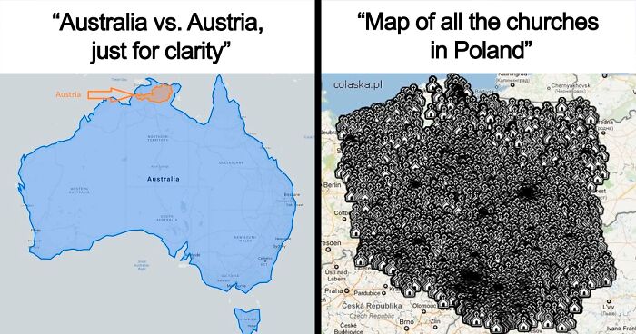
Wonder how many countries don’t change at all? I know Latvia, Austria, Poland, Turkey, Switzerland…
Latvia should be all white as their map is maroon, not red.
Load More Replies...MAGA folks would take all these red flags as evidence that Europe is communist 😆😂
This looks a lot like the map of flags showing only the red and white, with all other colors being white.
A Flag Map Of Europe But Each Flag Is Determined By Which Country They Share The Longest Border With
Is it Brazil for France because of their territories in South America/the Caribean?
The Most Popular Word In Each State
The Most Successful Music Artist From Each European Country
I can name a few: U2 (Ireland), Beatles (UK), Aha (Norway), ABBA (Sweden), Aqua (Denmark), Nana Mouskouri (Greece), Enrique Iglesias (Spain), Bjork (Iceland)
Bjork is a treasure to the whole world. If aliens landed tomorrow I want Bjork to be our representative. She already speaks the language.
Load More Replies...Yes, though I had to find a picture of them to check.
Load More Replies...I thought it might be Lordi's lead singer, but I can't find a picture of him without his costume!
Load More Replies...Finland: Martti Syrjä lead singer from Eppu Normaali - courtesy of Google ; D
I love that the band’s name includes the word ‘normal’ and the lead singer looks like that.. 😆😂 Go Finland!
Load More Replies...I can only identify the Beatles and ABBA - possibly Nana Mouskouri, although would have thought Demis Roussos would have outsold her.
Definitely Nana Mouskouri. Would know those glasses anywhere! I may be responsible for her popularity, as I have one more Nana Mouskouri album than I do Demi Roussos (one versus zero!).
Load More Replies...Map Of Honking Culture
Heat makes people mad, probably.
Load More Replies...Honking car horn uncommon in AMERICA??? Hahaha. Clearly haven't been in traffic in LA, DC, or NYC.
Im not sure, but I think it is not allowed or only sllowed in certain circumstances in Germany…
South America Flag Map. Don't Act Like This Isn't Sexy
Ecuador, Colombia and Venezuela share the same colors in the same order (only the symbol is different), because once the were part of the same country, the Great Colombia.
thank you, before this map and your comment, I had never realized that
Load More Replies...Sexy? It looks like the Andes are making a very rude gesture with Paraguay.
Topographic Map Of Africa
A Southerner's View Of The UK
Watford Gap is about 70 miles north of London. East Anglia is not included in the north.
Load More Replies...Hey, I am from Dorset too! What part of Dorset are you from? I am in Studland
Load More Replies...Map Showing Eastern vs. Western Europe
It does seem a bit complicated when you put it on a map, I swear it isn't when you just think about it.
How Far Are You From The Coast?
If the contents of lake superior were emptied out - there would be three feet of water covering the entire planet..it's a coast.
Load More Replies...How is it that the furthest from the coast isn't West of there? Compare how far it is from the orange area to the West Coast verses to the Gulf of Mexico and tell me an area more evenly distanced from both wouldn't be West.
US Governors By Eye Colour
Did you know that all people with blue eyes are related? The blue eyes mutation was because someone was involved with their cousin thousands of years ago. Weird, huh?
9000 years ago or so. And from Turkey. But at the end of were all related in some sort of fashion and we're all basically products of incest somewhere in the past.
Load More Replies...Wow that's wild considering most people have brown eyes. Northern European domination of power aka racism?
That is really interesting. I just learned about spatial autocorrelation, and how MOST things are clustered on maps. And while there is obvious clustering in this map, what would drive this?
Most common origin of migrants? Some towns are more historically German, others Italian, some are black majority, etc. People came to be with their familiar community and settled in bunches. Not sure, but maybe that?
Load More Replies...Population Distribution Of The United States In Units Of Canadas
I'm gonna give a huge shoutout to how well this map divided the US into 10 internally cohesive regions of equal population. As in: Cincinnati Ohio, Richmond, Charlotte and Nashville are all in the white region. It might surprise people to find that Cincinnati has more in common with those "Southern" cities than it has in common with Cleveland and the Great Lakes (yellow) region, even if their notion of chilli is profoundly perverse. Hell, I'd even easily name the would-be Capitol for each of these regions, with the only exception of New York City being more dominant than Boston, but Boston more typifying the red "New England" section. Boston, Atlanta, Dallas, Houston, St. Louis (Chicago is divided South side vs West Side, here!), Detroit, Pheonix, Boise, San Francisco, Pittsburgh. Seattle, Miami, and New York are too much on the edges to truly typify their regions. The only tough call is Memphis, New Orleans or Houston, but I figure Memphis is a good compromise.
We’re looking at you, countryhumans people…. (If you don’t get it, they, er, put countries in eachother…..)
Load More Replies...Whoever did this hasn't checked the populations carefully. Canada, 39 million. Yankland, 333 million. That's 8.5 parts, not ten.
Makes Sense
Maybe if they buckle down and drink more they'll see em
Load More Replies...The title of this map is UFO sightings but the shading seems it should be reversed.
I was gonna ask whether the people in Washington are really bored and looking for action, or whether the UFOs are :P
Load More Replies...Expectation vs. Reality
and it's not even spelled the same as the racial slur!!!
Load More Replies...There's Something Not Quite Right With This Map But I Can't Put My Finger On It
A Map Of The EU Made Out Of UKs
The refusal to use a UK for the UK, and instead relying on several misaligned UKs...
A Map Of The US If Every State Was Horribly Out Of Proportion
I think I live in that light blue one above the orange. It's usually a rectangle. Or maybe it's the dark blue one? Squished maps are hard.
Pizza Map Of France
Odd how just like as in America, the center of every city has the lowest income, while the suburbs of the biggest cities have the highest income. In America, this is blamed on the lack of public transportation.
Knowledge Of Cherokee In The EU
I wanted to make a joke about how 'we've all heard of the Jeep'. But I'm Irish, and we have tremendous respect for the native nations.
They took the whole Cherokee nation; Put us on this reservation; Took away our ways of life; The tomahawk and the bow and knife; Took away our native tongue; And taught their English to our young; And all the beads we made by hand; Are nowadays made in Japan; Cherokee people; Cherokee tribe; So proud to live; So proud to die;
The language or the people? Europe has made a great song called Cherokee.
Wait... why are Russians, Yugoslavs, Turks and Swiss learning Cherokee?
I have no idea what they’re measuring but this map is a riff on this: https://en.wikipedia.org/wiki/Cherokee_(Europe_song)
How Many Times Can You Fit The Population Of Scotland Inside England?
At first, I thought the numbers mean how many times you can fit it in that particular area...or do they?
Kind of. 3 contains Manchester and Liverpool, so it figures that the population density is higher there. 8 contains Norfolk, which surprisingly means that the population density is lower. ;-)
Load More Replies...('Oliver Twist' - film, 1968, if anyone's interested) Oliver-twi...c414d7.gif
('Oliver Twist' - film, 1968, if anyone's interested) Oliver-twi...c414d7.gif
