Admit it, once Google Earth was rolled out, you absolutely took a disproportionate amount of time checking out all the localities and areas on it to see if you can find something nostalgic, cool, or flat-out bizarre. And then Google Street View appeared and it was a game changer. Needless to say, you like maps. We’re all nerds like that.
And, well, there’s more to maps than just that. Check out these interesting takes on the US as seen from a top-down perspective, but instead of seeing vast landscapes and the occasional architectural screw-up, you see fun facts and information that might just make you smarter. I mean, it will if it’s not something you already know.
Scroll on.
This post may include affiliate links.
Topography Of USA
Not a mountain, though; there's a tiny notch of Minnesota that's surrounded by Canada on three sides.
Load More Replies...The mountains on the right (Appalachians) are made of the same stuff as the mountains in Scotland. They were the same place billions of years ago.
Go figure that they even named it New Scotland.
Load More Replies...when visiting family in Virginia, they took him on a drive to the mountains. My husband, a westerner, said those aren't the Blue Ridge Mountains, they are the Blue Ridge Bumps. Didn't go over well.
Tree Cover Map Of The US
Hold on, so the USA has a large Nullarbor (ie treeless) plain in the middle? Not just Australia?
Not only the US. Prairie: a large open area of grassland, especially in North America.
Load More Replies...The coconut plant is not a tree. It is a woody perennial monocotyledon.
Load More Replies...States With A Smaller Population Than Los Angeles County
And the entire LA county equals 1/6 the population of the Brazilian city of São Paulo. Now that’s a yuk moment. LA is charming in comparison
Load More Replies...9 times bigger than London with the same population! Or roughly the size of Beijing with 40% of the population.
In case anyone is wondering, the population of Los Angeles County is 9.83M.
Oh so about the same as greater London, but without any decent public transport 🤔
Load More Replies...I live in Arizona and we get a lot food from California. And they get food from us. It's called trading.
Load More Replies...The state I live in also has a Much lower cost of living.. I'll take that
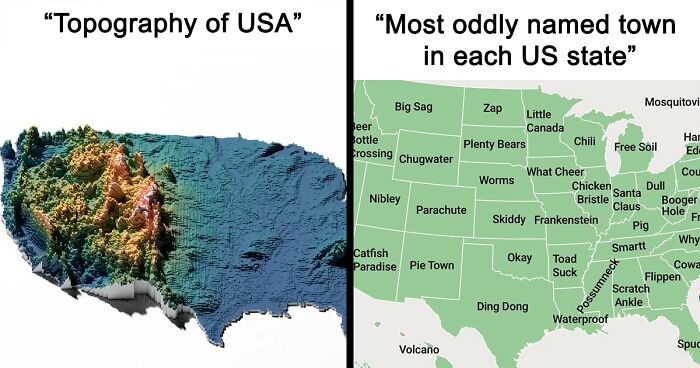
It goes without saying that the United States is a pretty big country. And, as such, there's ample opportunity to spot differences and variation on a slew of variables across the entire map.
Like, you probably never really needed to know how thick light pollution is across the US, but, hey, now you know that it’s the eastern part that’s very intense, and the western part is more or less not as polluted.
More People Live Inside The Red Area Than The Grey Area
Proof the electoral college is bogus. People vote, not land area.
The electoral college is based on people not land, proof you do not know how it works. See, each state has 2 Seantors, and 1 or more Representitives based on population size. Elector numbers are the number of Senators + number of Reps. So Alaska gets 3 electors and California gets 54. What this does it while it does have population be the factors in who wins, it also acknowledges every state having their own interests and prevents essentially 6 states from being the only ones that matter.
Load More Replies...And this, children, is why we have the Electoral College. I seriously doubt someone living in South Dakota wants someone living in New York, Massachusetts or California deciding who they get as president. I would think that EVERYONE deserves an equal say.
Without the electoral college, the people in grey would never be represented in the WH. Without the electoral college, we might as well just let LA county vote and go with it. The EC is imperfect and frustrating, but nobody bothers to read the history of our constitution to understand why it was put in place.
But if most people live there, why should their vote count less?
Load More Replies...Two bobservations. I.) The red areas control the votes. 2.) Much of the large area of the red in southern California and Arizona is sparsely populated desert land, so the population is really dense in a smaller segment of those areas.
One bobservation, people vote, land doesn't. OF COURSE the area with people controls the votes, they are the ones who vote.
Load More Replies...I live in a red area, Oklahoma (im pretty sure that’s my county)
The entire population of the planet could fit in Texas if we were housed at Parisian density. Not sure if that stat includes other things to support the population, such as schools and hospitals though!
I'm from Indiana, too. Peru, about 80 miles south of you
Load More Replies...Abandoned And Out-Of-Service Railroad Lines
In our area of Michigan, we have 2 major converted, paved, rail2trail corridors which cross in Reed City. One from Grand Rapids to Cadillac, and one from Baldwin to Bay City. About 150 miles total, if you are interested.
Load More Replies...Yup we can thank Henry Ford and the other capitalists of that era for buying up our railroads and shutting them all down, all so that the US would be built for the CAR and not for humans.
If he made enough money selling cars to do that doesn't it prove cars are what people wanted?
Load More Replies...Not necessarily, my area turns them into paved bicycle trails.
Load More Replies...Never understood why, using train for long distances is so cool. In europe you can go almost anywhere with train.
I would like to see a map of railroads that is being used. Would be interesting to see the difference.
No potential at all, Kirsten. These lines are refuse--they were, so to say, thrown out as trash. They weren't simply forgotten. Lots of them are ex-industrial ones for mines and the like. ALL o them are old and would be unable to carry modern trains. Very many are extremely short, or mere spurs leading to factory loading docks, hence economically inefficient. California's high-speed rail, authorized in 2008, is 16 yrs behind schedule, as not a single mile of track has been laid and costs have tripled. Imagine those billions be applied to something useful--housing, medical care, education--and perhaps you'll give up on the US-high-speed-rail pipedream.
Map Showing The Loudest And Quietest Areas In The US
All I hear is birds and bugs, the closest I get to noise pollution is the cicadas
The cicadas are going to get much worse in a few months once the super swarm hatches!
Load More Replies...Interesting.... there's a lot of noise in the Great Plains.... I doubt that's manmade. Just because sound travels so well, but (unlike the West), there's still plenty of birds and mammals?
Well, they don’t specify the source of noise, but some of the noise in the Great Plains could be farm equipment. However, the eastern Great Plains are well populated.
Load More Replies...Where it is showing the loudest is where most of the people live. What do you expect?
The yellow dots are metro areas, but what's fascinating is the midwest has so much grey between metro areas, whereas the Eastern seaboard has mostly blue.
Load More Replies...I'd love to see this overlaid with a map of the stops on Motörhead's final US tour.
And there is definitely a small contingent of people who benefit from this information—researchers, people who want to move states—it’s also there to make you look cool at parties with all that trivia you now know
All jokes aside, it’s useful to know where you’re going to live: what’s the crime rate there, how natural is the landscape, how populated it is—all of these factors are nice to know since you are deciding on moving there permanently.
Countries With Bases In The USA
This is interesting. I knew that the US has bases in other countries, but I didn't know other countries had bases in the US.
Same here. The Netherlands? LOL Training in the heat of Arizona so I guess they left their skates at home.
Load More Replies...There should be a map of how many different countries own land in the US…. China is large land owner.
Technically thats incorrect, UK has service personnel stationed at US bases, they are not UK bases
Their training bases here are small contingents at our military bases, under our watch and we train them. Our bases in their countries are full fledged with hospitals, schools, and weapons
Wow. I didn’t know they had bases here. Interesting. I must know more about it
If US Land Were Divided Like Us Wealth
Because Fox "News" + FB + right-wing politicians spewing BS and passing Christian-extremist policies = a brainwashed fearful population
Load More Replies...Because rebelling would affect their employment and they cannot afford to lose their income.
Because the majority of the 30, 20 and 40% are too voting for a party which makes riches richer. This two-party system is an illusion of a choice anyway. Why do you have only two parties? Why is the voting procedure so complicated? Why isn't every vote counted? Why is the outcome calculated rather than counted?
Lotta money goes into normalizing this for the population. We're entertained and fed enough to distract from how our infrastructure is crumbling beneath us and has been for decades. Discomforts that were socialist fears are becoming a late stage capitalism reality, long lines and long waits for basic services across the board.
I would be in the 1%. If there was a lower number, I would be that too.
Most Oddly Named Town In Each US State
I agree. For PA, I'd go with Intercourse, King of Prussia, and Bird in Hand.
Load More Replies...They are 100% wrong about New Mexico. That honor should go to Truth or Consequences
I spent a summer living in Volcano in Hawaii! It's on the big island and when I was there, all the town had was 1 diner, a convenience store, and a quilting shop. I learnt to make quilts haha
Load More Replies...Nothing particularly odd about Little Canada Minnesota. I might have gone with Embarrass. For New Mexico I would have chosen Truth Or Consequences.
Runners up from Alabama include: Smut Eye, Possum Trot, Lickskillet, and Bacon Level.
Sorry, I don't consider Little Canada, MN to be all that odd. How about Fertile instead? Or Savage? Or Kiester?
Really, you chose Little Canada for Minnesota....Climax, Nimrod and Embarrass are more weird 😉
But if that example is too specific, then maybe consider this: if you own a car, it’s likely that you use navigation on the regular. Apps like Google Maps and Waze have made it possible for people to have a bit more comfort in the car as at least you know where you’re going and why it’s taking you an extra 14 minutes to get there (darned traffic jams).
United States Population Lines
US States Scaled Proportionally To Population Density
I know it isn't a state, but there's no DC and it is pretty densely populated
Give me land, lots of land under starry skies above, don't fence me in...
Light Pollution In The United States
So glad I live where this is none, I enjoy going out and looking at the stars, the moon, the milky way...
I live about 40 minutes north of Seattle & growing up you could see every star in the sky- the area was mostly farmland & quiet. Now, you're lucky to spot the brightest constellations & there is always traffic white noise 😪
Load More Replies...I HATE that there is so much light pollution in central Florida. I want to see the Milky Way and be inspired and moved by its beauty. Best I get is like, 8 stars and after a second 4 start moving and I realize they’re airplanes
Save electricity and turn off those annoying yard lights and dim the street lights.
You get to the west side of the map, you think you've escaped, and then DENVER
Yup, the eastern part of the US is more densely populated than the western part.
Load More Replies...Its actually insane how many stars you can see up in rural California
But seeing that arrow in your navigation is one thing. There’s an entire surrounding everywhere you go—knowing what’s around us brings us comfort and safety. And you never know when a beautiful lake will be sitting right next to where you keep passing by, but never look beyond that patch of trees that disguise it, making you think it’s just more forest there. Maybe taking a bicycle might help fix that problem. But check your map first!
The Most Efficient Route Between Every Springfield In The United States
I've been to Springfield oregon, the home of the Simpsons. The town has great donuts!
I live right by Springfield! theres so many simpsons murals there its pretty cool
Load More Replies...Imagine if Johnny Cash had been on THIS tour? "I've been through Springfield, Springfield, Springfield, Springfield, Springfield, Springfield, Springfield, Springfield, Springfield, Springfield, Springfield, Springfield, Springfield, Springfield, Springfield."
Load More Replies...I'm tempted - besides, think of all the great microbreweries one could visit.
Load More Replies...Springfield, Oregon got its name... literally... because there was a water spring in a guy's field.
Load More Replies...US States By Violent Crime Rate
Alaska has a high domestic violence rate. Many villages and communities have banned alcohol to counteract the problem.
Load More Replies...Maine seems pretty chill, considering all the things Stephen King says happen there.
Maine should become part of Canada; it has no business in being in America
America should become more like Maine. (OK, people can opt out of the Stephen King stuff.)
Load More Replies...Average Color Of US State Based On Satellite Imaging
Given the colour range, this is likely just one season, perhps spring or summer. Alaska has some pretty large forest cover, it's probably from that.
Load More Replies...It is good to see a lot of green. Hopefully that means those states are heavily tree populated.
Interesting how Washington, the Evergreen State isn't as green as some of the others. But it is the greenest on the West side of the country.
Another argument for the importance of maps is the idea of seeing where you’re going, where you are, and where you’ve been. It doesn’t really have to be a literal geographical map at this point, but a literal one might work too—just think of Google Maps Timeline.
If you’re unaware, Google Maps Timeline is a monthly service by Google that sends you recaps of where you’ve been over the past month, showing how many countries, cities and places you’ve visited in retrospect.
US Racial/Ethnic Diversity Map
I'm happy about Texas, but the number of people in Texas not happy about Texas makes me sad.
I think it’s because the more racial diversity there is, unfortunately there will be more people who are racist 😕
Load More Replies...I'd be interested in knowing which groups they considered "ethnic groups". If the two people picked were of Swedish and Italian descents, would that count?
This is what makes me angry about some of the states that have the first primaries. We don't get a representation of the US until we hit the Carolinas.
It's so sad to see that this map is in high correlation with the "Violent crime rate" map :(
Right? Sadly the high diversity is actually dangerous.
Load More Replies...What the hell is going on up in the northeast (besides New York)
Consider why other parts of the country ARE diverse. The south-east has a high African American population because slavery. The south-west has a high Hispanic population because obviously that is where Hispanic immigrants arrive. The mid-west is where we forced Native Americans to live, and also with it's low population density relatively few immigrants change the percentage significantly. Major cities like New York attract people from all over. New England especially Northern New England (Maine, NH Vt) don't have any of those factors. They were early British colonies, there was a large wave of immigration in the early to mid 20th century to work in booming mill towns, but they were largely from Quebec. There aren't a lot of major urban areas , but cost of living is relatively high. That said, diversity has increased substantially. Small cities like Manchester and Concord NH have welcomed many immigrants in recent years.
Load More Replies...Most Spoken Languages In The US Beside English/Spanish
“We have languages coming into our country. We have nobody that even speaks those languages. They’re truly foreign languages. Nobody speaks them.” Trump
Maybe he really does know what he's talking about. (Jk, of course he doesn't) This map shows languages he's never heard of.
Load More Replies...Actually, Chinese people refer to their language as 汉语 (hànyǔ), which translates as 'Han Language', which encompasses all the dialects and variations. They may call Mandarin '普通话 (pǔtōnghuà)' - 'common speech', and written Chinese would be '中文 (zhōngwén)' - Chinese Language. Mandarin and Cantonese are the most common for foreigners to learn, but you are diminishing many Chinese languages by your erroneous claim. Chinese people call it Chinese language.
Load More Replies...It was the Vietnamese in Texas that seemed oddest to me.
Load More Replies...Most Americans' origin is German/Scandinavian, so makes sense.
Load More Replies...Dakota languages? Is that a type of Native American language I’m not familiar with?
NJ here, only met one person in my lifetime in NJ that spoke Portuguese, Now Italian or Haitian Creole....
Right? I've lived in Jersey my entire life and I've literally never met a single person who spoke Portuguese. That was a surprising stat to see on that chart!
Load More Replies...I have rushed on this one and did not read the title, so i was really amazed than Vietnamese was first after english in Texas ! Dumb me
The Chicago area has the second most Polish people outside of Poland.
Load More Replies...I love that my state Arizona has Navajo which is its true indigenous language
Define Chinese. We have a number of Cantonese speakers in California but more Mandarin speakers are coming in. I thought our second language would be Tagalog.
Most Popular Dog By US State
Well, in California, you have your meth labs and your fentanyl labs, and of course crime labs.
Load More Replies...Fergus is a great name for a corgi. The one I have now is Li'l Tex.
Load More Replies...Alice Jones! There's nothing better than a Lab, except maybe 2 Labs!
Outside their practicality, maps also ground us in reality. That can be either a good or bad thing depending on a number of factors, but there’s the idea that maps remind us we all live on the same planet. Sure, there's a great divide among nations and countries in terms of social, economic and climate factors. But we’re all in this together—we’re all citizens of this world. And that’s what folks ought to focus on.
Usage Of 'Dang' In The United States
Are there signs at the edge of the red area that say 'Welcome to the Dang-er Zone'?
Boomhauer lives deep in the red, as one would imagine. (Boomhauer is a character on King of the Hill that says "Dang" a lot)
I live in Michigan, and I say it all the time! There should be a red dot representing me just south of the thumb knuckle.
Map Of The United States' 8 Million Miles Of Roads, Streets And Highways
And I have driven 2 million miles of them. The only states I have not driven every inch of Interstate in are Montana and North Dakota.
North Dakota can be covered in a day. I've driven all of 94 and 29 from Grand Forks South.
Load More Replies...I love how the Interstate Highway System came to be. It has made our country easy to travel and I love that!
The way it was approved and funded was by justifying it as part of the defense budget.
Load More Replies...Route 80 goes practically the entire length of the USA horizontally from The Hamptons in Long Island NY all the way to the Golden Gate Bridge in San Fran CA. Route 95 Goes from the tip of Florida to Maine. This was supposedly done to have easy transport during war. They say you can land planes on both highways if needed.
Overpasses need to be tall enough to accommodate the military transporting icbm's and other large equipment by truck. Im not exactly sure about North/South routes but I think any east/west route that ends in 0 covers the entire country i.e. I-90 runs all the way from Boston to Seattle
Load More Replies...My state has interstate highways, but isn’t even on the map. Maybe because those interstates never leave the state?
Technically those are INTRAstate highways then.
Load More Replies...Some might argue that maps help us stay curious. Just like a change of scenery can help us gain some perspective and learn something about ourselves and others, i.e. travel, the idea of looking at a map and plotting your next adventure might just inspire an extra bit of curiosity and make you think “hey, I’ve never heard of this place.”
US Obesity Map
The poorer the population, the fatter the population, due to food deserts and prevalence of cheap processed foods in those areas. Poverty and malnutrition are also, obviously, tied to education.
You mean the GOP controlled states? Cuz it sounds like you're describing the GOP controlled states...
Load More Replies...Barely edible cheap food made with high fructose corn syrup will do that. Thanks Capitalism, I hate it
No surprise Mississippi is almost entirely red. Time and again I read Mississippi is our fattest state.
Load More Replies...If it's based on BMI, it might not be a great measure for the Inuk people who are proportioned differently
Load More Replies...You can thank your beautiful mountains for that! You mountain people are WAAAAAY more physically active than us flat landers lol 😅
Load More Replies...How America Utilizes Its Land
I feel we should be devoting at least as much land to maple syrup as we do to golf.
And also, how is "wildfires" a commodity?
Load More Replies...In order to produce 1 unit of beef you need to feed it 4 units of grain. We waste unimaginable amounts of food and water in order to gorge ourselves with beef. I love beef by the way, I just can't justify eating it all the freaking time! Meat should be a treat.
Yes. I don't understand people who eat meat and poultry every single day, two meals a day minimum. Way too much unnecessary meat in the diets. Two or three times a week is all that's necessary, and much better for health.
Load More Replies...Note that livestock feed takes up more land than food we eat. One more reason to go vegetarian!
That area for cows is largely desert or subdesert with not a lot of vegetation, so one cow needs a whole lot of grazing area. But you’re right, Americans in general eat way too much meat and not enough fruit and vegetables.
Load More Replies...Im not sure that "wildfires" technically count as a utilization...
No one is talking about the private logging company, Weyerhaeuser, in the lower left box where cali meets arizona.
The three blueish on top together with "cows" explain in an excellent way why the US are so keen on killing off all wild horses in the most brutal way. The main reason is "they are vermin, they don't belong here" - which is historically not true, there were horses even before Europeans set foot on the US. The type of cows, taking over the homes of the mustangs do not belong there, either. They too are non-native animals. It always baffles me that the countries (Australia, too!) with a massive, not inhabited land area are panicking about a couple of thousand wild horses destroying the landscape. At the same moment, in comparsion tiny countries as the Netherlands and Germany where every square kilometre is fought about, cherish their wild horses and not only reserve areas for them, but are happily "employing" them to keep the ecosystem intact, so a huge variety of wildlife can find food and shelter.
Wild horses are so beautiful. Shout out to Mick Jagger.
Load More Replies...How do "wildfires" utilize land? And the area shown is much too small in recent years
It uses up land that could be used for other things.
Load More Replies...Do you know why so much is devoted to cattle? Because grazing animals is the best use of all the native grasslands. Mixed in with the cattle herd are Bison, deer, antelope, and elk. But, this survey didn't c**t the natural land uses.
US Territories
No need to be an Empire of Conquered Land when you can just be the Empire of Global Capitalism. Would be nice if we actually were the "Empire" of Democracy, but unfortunately we don't live in that timeline...
The Sun never sets on the "Freedom" Empire.
Load More Replies...When you add up the square miles of all these territories it equals our smallest state.
For a second I thought that one bit said "Klingon Beef" and my mind chose not to question it for like ten seconds. Hawai'i: The Final Frontier.
I like that. Maybe the US needs to find some unclaimed island and clam it name it Klingon Beef .I have a few friends that like Star Trek and they would approve that.
Load More Replies...And to think that FDR was so concerned about the British re-establishing their empire after ww2...
Um, what is marked as "North America" is Canada. And where is Mexico?
The Most Dangerous Cities In The US
If we removed the 5 highest murder cities in the US (which only have 3% of the US population) the us moves to one of the lowest homicide rates in the world. Eliminate the top 10 with just 5% of the US population, we rank around Norway per-capita ranking. Most of our violent crimes and murder are a few area with just a tiny part of the US population. What the data shows is rather than sweeping large scale legislation (which for decades has not worked), we need focused surgical policies on those hot zones
There are only 6 cities on that map that I don't go to on a regular basis. All the others I visit, usually once a month, I have never had a problem. In 20 years of driving around the US, I've never carried a gun or even needed one. But I hate Cleveland, too many serial kiIIers.
Hey now. I moved to Akron five years ago, you should be good.
Load More Replies...I wonder why Minneapolis is so dangerous? Definitely not because we let a bunch of people riot and burn down minority buisneses and a police precinct? It also has nothing do with Liberal Judges letting out convicted murderers out of jail and then trying to ban civillians from owning guns to defend themselves. /s
"We'll try to stay serene and calm, when Alabama gets the bomb"--Tom Leher
Yeah, well, I'm about five miles south of San Bernardino, so... yeah, it belongs on the list.
Load More Replies...Which Coffee Shops Has The Most Locations Per State
It's more like a dessert in a cup, except that it has the caloric value of an extra dinner. As a Dutch person I have to mention that we're considered large eaters in Europe. American portion sizes are still at least twice of what's sold here.
Load More Replies...Caribou rocks, we have 90 more of them in MN than there are Starbucks shops im surprised its that many
Load More Replies...Same here! Besides, I prefer "mom and pop" places - or Caribou.
Load More Replies...Ahhhhhh...Minnesota, I love ya...Caribou and where we play Duck, Duck, GREY Duck and not duck, duck, goose....😉
We have pop and hotdish. Not soda and casserole. We some us those but for the most part POP and HOTDISH🥳
Load More Replies...I’ve never heard of Caribou, I feel like I live under a rock now…🫣
Minnesota based chain, better coffee than Starbucks for sure
Load More Replies...Lastly, maps are an integral part of how we function as human beings. There’s a geographical map (of which there are many types), a building evacuation map, a website map, a mind map, process maps, network maps, story maps, treasure maps, and, to some degree, flowcharts. Needless to say, we need all of these. Especially treasure maps.
Highway Signs For Each US State And Territory
Utah is a beehive. Frankly, I think all state routes should be shaped like the state, it's annoying.
Live right by 49 in NorCal. It winds through some beautiful foothills and mountains.
Hawaii gets a guitar pick‽ nice. Why is Texas so boring. I didn't know other signs were so cool.
I believe Hawaii’s signs are supposed to depict a stylized beehive.
Load More Replies...NE coast states so un original and boring... NJ here, black square with white circle and a number inside...
Red And Orange Areas Have Equal Populations
Are we adding the orange areas together? Or is each orange area individually equal to the red area?
Several different way so far to say "the electoral college is destroying democracy".
Check Australia's distribution. A whole lotta inland with a whole lotta unoccupied space.
Load More Replies...Most of the world’s population lives on coastlines so this is hardly surprising
Origin Of US State Names
So with Idaho they were just like "what is the weirdest name you can come up with?"
And the answer was 'I dunno'. Excuse me, did you just say 'Idaho'?
Load More Replies...It was named after the Duke of York at the time. He became James II after his brother died.
Load More Replies...I assume it says that California is "derived from European Words" because Spain conquered Mexico 300 years before the U.S. took California from them.
Derived from Spanish, which is originally a European language
Load More Replies...New York is named after York in the UK. The person was named after the place (as in Duke of?).
Nope. New York is named after the Duke of York. The title Duke of York, is mostly given to the second son of the reigning monarch. It wasn’t named after the city of York. New Jersey was however, named after the island of Jersey in the Channel Islands, for their loyalty to Charles II.
Load More Replies...Tennessee was named after the Arrested Development song, obviously
No. It was named after the Duke of York (Charles II’s brother), not the city of York.
Load More Replies...Air Traffic Control Zones In The USA
I suspect there is not a lot of air traffic in those areas.
Load More Replies...I'm impressed that anyone in Minneapolis would even care about the air traffic in Fort Frances / Rainy River in Ontario.
Average Money Spent On Weddings In US States
WY is the only state that seems to spend a sane amount. CA is out of control!
Well, it is Wyoming. I suppose if you invite fifty people, that's about half of the state's population.
Load More Replies...If only people would invest as much into their relationship as they do a pompous wedding.
Ok I’m not from USA, but I think these amounts of money for a wedding are insane, I know it’s the same in the UK , but it doesn’t have to be that way. If you can easily afford it, fine but you can have a really great wedding for much less. My whole wedding day including both outfits and rings cost around £1000, best day ever 💕
South Dakota, we gotta have a talk. Your average yearly income is 44k...
What's up with South Dakota? Are there a bunch of secret millionaires living there?
So, what are your thoughts on any of this? Have some maps that you were blown away by? Share them, or anything map related, really, in the comment section below!
And if you need more maps, we’ve got tons. No, that’s not an overstatement. Yep, it keeps on going. OK, that’s enough.
Here’s A US Map Showing Where Horror Movies Took Place (By Andrew Brick)
I can vouch for where Hitchcock's Birds was filmed. The church is still a functioning Catholic Church.
The Dead Next Door! I went to the 25th Anniversary screening, met Bookwalter (however briefly), etc. I didnt know anyone outside northeast Ohio had even heard of it!
Purchased Territories Of The USA
The manager “Karen” refuses to except the return 🤷♂️
Load More Replies...The second line of text is in Hungarian, and it is hilarious because it reads ‘territories purchased by oosaa’, instead of the more common ‘eggyesült államok’ or ‘united states’
😂 "oosa" reminds me of a time I was waiting for food and this person wasn't responding to calling out for "Oosa" or "Yewsa." I started helping them yell out for this person on the carnival grounds. . 😂 It was me, my food, and the letters "L" and "I" ran together and looked like a "U" so Lisa became Usa
Load More Replies...The Gadsden purchase seems very expensive compared to the rest when you look at the amount of land.
That was a fairly equitable purchase: a relatively small strip of desert land so a railroad would not have to be built through mountains.
Load More Replies...Florida and Mexican both cost 5 million dollars. Florida was bought first so would have experienced all the same inflation that Mexican did plus an additional 29 years and somehow in 2023 it's worth less. Doesn't make sense.
I don't know. I think the value of Florida has gone down. I don't think we'd be able to give it away in this day and age.
If there were a map of the stolen territories, would it just be all of it?
US State Mottos
I don't think North Dakota understood the assignment. That's way too long for a motto.
It's hard to see, but those are two separate mottos. There's a teeny, tiny little "and" in the middle.
Load More Replies...I fear many of these states have forgotten their own mottos...mine included. Friendship.
I think the Indian word Tejas also means friendship.
Load More Replies..."Thus always to tyrants" I think VA wins, especially since our motto is accompanied on our flag with a tyrant being murdered.
South Carolina's unofficial motto is "Thank God for Mississippi." Because they usually keep us off the very bottom of rankings.
Montana's just lays it out there unapologetically: gold and silver. Nuff said.
Florida wasn't very creative were they? Their motto is literally the same as the whole country's.
California: "I have found it"... Oregon: "She flies with her own wings"... New Mexico: "It grows as it goes" 😭 what the hell sort of mottos are these
I read Oregon's as "She lives with her onion rings." The font is too cräppy on my phone.
Load More Replies...So most of our mottos are in English, classical languages, maybe Spanish and only Hawaii has the language of the people who live there.
Regions Of The U.S. That Don't Officially Celebrate Christopher Columbus Day
South Dakota observes it, and "indigenous peoples Day" on the same day. Basically it's celebrate whichever one you want. No school, banks and post offices are closed.
California should have more yellow in there at least if I remember right we switched to ingenideness people day.
The holiday was instituted due to the lobbying by the Knights of Columbus. I wonder how they feel about it being cancelled or changed now? Think they might change their name?
Most Expensive Toll Roads In The US
Roads get paid for two ways: taxes or tolls (sometimes both). Build, operate, and maintain.
Load More Replies...I was a bit shocked when I hit the tolls in Pennsylvania, I was expecting it to be a few dollars like they are in other places, but it was double digits, I had to dig in my pocket for enough cash! But usually tolls are worth it in terms of cutting out more difficult routes
I really thought the Indiana Toll Road would have been on that list.
CA is adding more all the time - we'll kick everyone's butt on this one I'm sure.
So, what do you get for your money on the PA turnpike? Do they drive your car for you? Carry your car on convicts' backs so you don't waste gas? Massage your butt for the entire drive? Wash your balls at the end? What?
It used to be that on the PA turnpike, you had to exit for gas, food, rest stops and then pay to get back on. Other toll roads make those conveniences accessible without having to pay again!
US States By Wikipedia Article Length
Yeah, it;'d be fun to see an 'article length per population' map.
Load More Replies...Aww, poor Nebraska, Wyoming, New Hampshire and - Maine? Why Maine?
Because no one has submitted an article on those states!
Load More Replies...The Most Popular Unisex Baby Names By US State (2020)
Logan and Dylan are considered unisex? Always thought it was a boy's name. Never heard of a girl named Logan or Dylan.
These aren't unisex, they're BNOG. (boy names on girls - you never see the opposite.)
I don't feel like these are unisex names. I have never met a female Avery, Logan, Carter, Sawyer, or Oakley. I vaguely remember one Dylan.
The Safest Cities In The US
So apparently I live in the safest town, we definitely didn’t just have a triple homicide, domestic abuse that I’m pretty sure ended in death, someone stealing a bike and returning it with a bloody shoe, and bomb threats at school, were real safe
Safest doest mean safe. Just that in other cities is way worst.
Load More Replies...This must be very old. As of 2023 3 of the top 15 safest cities in the us (for a population of >300,000) are in California, and 6 of the top 15 safest cities in the us (population 100,000 to 300,000) are also in California.
Only counting places with a population of 25,000+. But I would bet that that the safest places are those with a population under 10,000.
This isn't exactly accurate, since none of these places are "cities" as the rest of us think of them. Closest things to an actual city are probably Andover or Lexington.
We used to live in a listed 'safe city'. It was busy tripling in size and population, and the prices of everything skyrocketed. That ran the gangs out of town, but the d***s are still there. There was a guy riding his bike along a rode and got shot by a sniper gun. Real safe!
Hm. There were a couple of violent crimes in a few of those North Texas cities, and I don't remember any lately in the one I live in, but I wouldn't exactly say my North Texas town is crime free. Lots of break ins, many cars and trucks stolen or broken into. The crime around here is mostly due to homeowners being careless.
I am glad Michigan has a few of these to counteract all the dangerous ones.
US Pronunciation Of Pecan
Until one realizes this is a fight everywhere in the US, as common a disagreement between CARmul, CAR-a-mell, and CARE-a-mell.
Load More Replies...It is pick-HAN if you are selling and PEE-CAN if you are buying. Also GA is not nearly green enough
It's puh-khan. Period. Pee-can is what you use when the toilet is out of order.
Most Popular US Female Baby Names 2022
My last name is Harper, so when I hear, Harper! I think someone is yelling for me. They aren't.
Illegality Of Women Going Topless In Public In The US
So, you are telling me in all the states in white, it is not illegal? Yeah well, I think this map is a little skewed.
State law is not county/city law. Most indecency laws are local
Load More Replies...Donahue. Remember him? He had an entire show about this for women in, I believe Rochester, NY, and they won their court battle. Unfortunately. Most of us are better off clothed. Self included.
In Massachusetts, you have to have your nipples covered in public. My brother's ex girlfriend, found this out, and started walking down the street with ✖️✖️, made out of electrical tape. I have to point out, she always wore a top at home, when swimming, or any other places you might reasonably expect to be topless. It was all for the attention, and getting to be "offended" by people's looks. That girl loved being offended.
I have never seen a topless woman in California but I know that nudity is not illegal in some towns.
Yay Florida! You be legally ambiguous! Let the cops decide case-by-case, based on how nice the set being exposed is. They would arrest my 57-year-old a*s in a second, after going blind, of course.
US Housing Shortage
Now change it to AFFORDABLE housing. There's no housing shortage. We're being gouged.
Define affordable? Everything is affordable if you have enough money, nothing is if you don’t
Load More Replies...So Southeast FL has one of the highest GDP's but one of the most severe undersupply of housing? Checks out.
Oh, yeah, Miami. You basically have a choice of a slum or a house you can't afford. The Miami-Dade County School Board is actually considering building dormitories so teachers can afford to live there. Great hiring point. Come live and work in one of the most violent cities in America! We'll let you live like when you were in college!
This must be so out of date! They say an adequate supply is a median house that is affordable on a median income. Our median-priced homes are in the $450k range while our median incomes are around 90k. That is not affordable!
US Counties With GDP Over $100b
The cities. Boston, MA - Philadelphia, PA - Atlanta, GA - Miami, FL - Houston, TX- San Antonio, TX - Dallas-Fort Worth, TX - Phoenix, AZ - San Diego, Los Angeles, San Francisco, CA - Minneapolis, MN - Chicago, IL - Detroit, MI.
They missed some, I live in NYC and 3 of the 5 counties of NYC (also known as Boroughs) and several nearby counties should be on that list.. NY County (Aka Manhattan) 780 billion, Queens County, NY (also known as the Borough of Queens in NYC) 104 Billion, Kings County (aka Brooklyn) 107 billion. Nassau County, NY (NYC Suburb on Long Island) 121 Billion, Suffolk County (the whole Eastern Half of LI) 125 billion, Westchester County (the one right north of NYC) 103 billion. Our whole state has a $2 Trillion GDP overall, which 6 counties of over $100B making up 55% of that 2 trillion on their own.
Atlanta is the biggest business hub in the south..
Load More Replies...Seat Belt Laws In The US
After living in CA for most of my life, I feel super weird to be in a car without a seatbelt on.
My parents enforced it long before it was law anywhere. I don't like the feeling I might slide out of my seat so I never had a problem when the laws were passed.
Load More Replies...Ahh NH who takes their motto: Live Free or Die literally. The number of deaths caused by head injuries in NH is staggering, but the backassward people will not put seatbelt or HELMET laws onto the books. No helmets required for motorcycles, skimobiles, etc.
So how does the US get away without having seatbelts in buses (esp school buses)?
Actually a good question. Need them on planes, albeit I wear mine so I don't get sucked out if the side busts open. Glad I had mine on 5 years ago when rear ended by a truck while stopped at a red light, and they were going full speed. If not I would have been thru the windshield
Load More Replies...US States By Human Development Index
Wikipedia - Human Development Index (HDI) is a statistical composite index of life expectancy, education (mean years of schooling completed and expected years of schooling upon entering the education system), and per capita income indicators,
Load More Replies...No surprise most of New England is dark green - and that Massachusetts is #1
it is interesting how many maps have a distinct division just west of the Mississippi River
Bored Pandas done multiple articles like this covering the whole world, just search “Maps” and im sure it will pull them up :)
Load More Replies...A quick not exhaustive search turned up: two weeks to seven years.
Load More Replies...Use the top of page search field: "maps europe" or just "maps"
Load More Replies...I love stuff like this because I am very visual, I like charts too.
