ADVERTISEMENT

If you're looking for a cool hobby, studying maps might be it. They are like time-traveling storytellers, murmuring stories from hidden corners of countries, the ebb and flow of populations, and the shifting borders across time in history. They're engaging and can easily captivate your attention for hours, much like the 2.6 million members of one special Reddit community.

We invite you to enter a cartographer's dreamland, where lines and colors come together. You might find yourself captivated by the various marks, boundaries, and notes, joining the ranks of map enthusiasts. Give your best-liked maps an upvote and share in the comments the ones that made you want to take up this hobby.

#1

A Map Depicting The Changes In Costa Rica's Forest Coverage Over Time

A Map Depicting The Changes In Costa Rica's Forest Coverage Over Time

d-williams Report

Add photo comments
POST
brouwermarije avatar
mandy the capibara
Community Member
9 months ago DotsCreated by potrace 1.15, written by Peter Selinger 2001-2017

This makes me happy! Let's hope it is diverse plantation though, and not monoculture production forest.

View More Replies...
View more commentsArrow down menu

Maps capture our attention by blending art, science, history, and exploration into one visual picture that informs and inspires, creating an endlessly captivating and distinct part of human culture and knowledge.

#2

A Dissected Globe Made In 1866

A Dissected Globe Made In 1866

Lepke2011 Report

Add photo comments
POST
owenjarvis avatar
Owen
Community Member
9 months ago DotsCreated by potrace 1.15, written by Peter Selinger 2001-2017

This is beautiful. A globe makes a great feature in any house, and you will refer to it more than you think. But this one is gorgeous.

View More Replies...
View more commentsArrow down menu
#3

No Hurricane Has Ever Crossed The Equator

No Hurricane Has Ever Crossed The Equator

Hockputer09 Report

Maps are important because they guide us through the world and offer crucial geographical insights. They act like history books, tracking how places and societies have changed over time, and also work as tools for scientists to study patterns and natural occurrences. Maps help during emergencies, city planning, and protecting the environment. They also support learning, preserving cultures, and connecting people worldwide, even if they speak different languages or come from different places.

#4

Map Of Africa Using Ethnically Drawn Borders

Map Of Africa Using Ethnically Drawn Borders

rustyyryan Report

#5

The European Green Belt, Is A Wildlife Corridor Connecting Many National Parks, Built Somewhat By Mistake Over The Iron Curtain During The Cold War

The European Green Belt, Is A Wildlife Corridor Connecting Many National Parks, Built Somewhat By Mistake Over The Iron Curtain During The Cold War

tomydenger Report

#6

1529 Map Of The Americas By Diego Ribero [5701 X 7674]

1529 Map Of The Americas By Diego Ribero [5701 X 7674]

girusatuku Report

Add photo comments
POST
zeljkoklaric78_1 avatar
Bernd Herbert
Community Member
9 months ago DotsCreated by potrace 1.15, written by Peter Selinger 2001-2017

I can't even begin to understand how this was possible to create in the 16th century!

View More Replies...
View more commentsArrow down menu
ADVERTISEMENT

Map symbols are crucial as they stand in for real-world objects in a simplified way, making maps meaningful. These symbols can take the form of shapes or colors. For example, a small brown circle might mean a recreational spot, red could indicate services, and green might signal a rest area. Colors, too, play a role in representing larger features: green could mean forests and blue could represent water on a map. To ensure proper map reading, a Map Legend acts as a dictionary, explaining the symbols used on the map and their meanings.

#7

The Bizarre Border Between Finland And Sweden On Märket Island

The Bizarre Border Between Finland And Sweden On Märket Island

patrickmcgranaghan Report

Add photo comments
POST
laura_ketteridge avatar
arthbach
Community Member
9 months ago DotsCreated by potrace 1.15, written by Peter Selinger 2001-2017

Finland built a lighthouse, not realising it was on the Swedish side. This new border was drawn up to allow the lighthouse to be Finnish, and the amount of land held be each country to remain the same.

View More Replies...
View more commentsArrow down menu
#8

The Real Massachusetts

The Real Massachusetts

MoreGull Report

ADVERTISEMENT

The earliest recorded map is the 'Imago Mundi', also known as the Babylonian Map of the World. Considered the world's oldest surviving map, it currently graces the British Museum in London. Dating back to 700-500 BC and discovered in Iraq's Sippar, this carved relic centers on Babylon, surrounded by areas like Assyria and Elam, all encircled by a "Salt Sea." Eight islands or regions lie beyond this border, etched into the tablet. The map is accompanied by cuneiform text describing Babylonian mythology linked to these regions depicted on the stone.

ADVERTISEMENT
#10

Android vs. iOS In Europe

Android vs. iOS In Europe

JoeFalchetto Report

Add photo comments
POST
owenjarvis avatar
Owen
Community Member
9 months ago DotsCreated by potrace 1.15, written by Peter Selinger 2001-2017

Android is the way forward. Apple tried to make a monopoly and failed due to greed.

View More Replies...
View more commentsArrow down menu
#11

Over 20,000 Flights ‘In The Air Right Now’

Over 20,000 Flights ‘In The Air Right Now’

Roy4Pris Report

#12

The Himalayan Weather Wall

The Himalayan Weather Wall

two_plus_two_is_zero Report

Add photo comments
POST
msonntag1028 avatar
Delta Dawn
Community Member
9 months ago DotsCreated by potrace 1.15, written by Peter Selinger 2001-2017

Something about hitting enormous mountains and then a 4000 m high plateau tends to change the local climate a wee bit

View More Replies...
View more commentsArrow down menu

In today's Digital Age, maps are readily accessible—a simple tap on your smartphone and you're on your way to the nearest Starbucks for a quick coffee break. Apps like Google Maps and Citymapper are making things easier, says researcher Mike Duggan from Royal Holloway. He's found that these new technologies are simplifying the complex systems we navigate every day, especially in cities.

#13

Life Expectancy In America

Life Expectancy In America

Yiddishstalin Report

#14

Today I Bring To You Large Zeland

Today I Bring To You Large Zeland

Stormfather21 Report

Add photo comments
POST
andrew-w00197 avatar
Did I say that out loud? (he/him)cis/het
Community Member
9 months ago DotsCreated by potrace 1.15, written by Peter Selinger 2001-2017

It's nice to see New Zealand on a map at last. But what is "Australia " doing there? Everyone knows it's not real.

View More Replies...
View more commentsArrow down menu
#15

Population Distribution

Population Distribution

Vaguelymortify40 Report

Add photo comments
POST
vmblessing avatar
Verena
Community Member
9 months ago (edited) DotsCreated by potrace 1.15, written by Peter Selinger 2001-2017

From top left: Canada, UK, Germany, Japan - South Africa, Philippines, [Edit: Australia], New Zealand. I too had my doubts, e.g. Berlin and Munich (in Germany) should be dots, however, these are huge cities in areas of otherwise very low population, so depending how this was calculated, could be still correct.

View More Replies...
View more commentsArrow down menu

Having a map in your pocket is a new thing. In the past, people were okay just knowing their local area. As maps got cheaper, they helped make sense of growing cities. Small maps for pockets were a big change.

ADVERTISEMENT
#16

Potato Consumption Per Country In Europe

Potato Consumption Per Country In Europe

Money_Astronaut9789 Report

Add photo comments
POST
bronwyn-cook3 avatar
BC
Community Member
9 months ago DotsCreated by potrace 1.15, written by Peter Selinger 2001-2017

Boil ‘em, mash ‘em, stick ‘em in a stew… 🤘🏻😎

View More Replies...
View more commentsArrow down menu
#17

An Interesting Map I Found Of World Cloud Coverage

An Interesting Map I Found Of World Cloud Coverage

coolperson-6408 Report

#18

Spain Is Gonna Change Its Name To Mordor! Surface Temperature Map

Spain Is Gonna Change Its Name To Mordor! Surface Temperature Map

Shevek99 Report

Now that we've explored why maps are interesting and important, keep scrolling to gain further insights from these captivating maps. And if you're eager for more, be sure to explore our previous editions featuring intriguing maps—found here, here, here, here, and here.

#19

What Year Is It Right Now?

What Year Is It Right Now?

ledim35 Report

#21

Percentage Of Urban Tree Cover In The European Capitals

Percentage Of Urban Tree Cover In The European Capitals

quindiassomigli Report

Add photo comments
POST
star44886 avatar
Will Cable
Community Member
9 months ago DotsCreated by potrace 1.15, written by Peter Selinger 2001-2017

Our local government annoys me about this, beautiful wide road and they started to remove trees claiming they were damaged etc, didn't replace a single one, the houses etc are far away too from them

View More Replies...
View more commentsArrow down menu
#23

France 1848 Election By Dodi Maps

France 1848 Election By Dodi Maps

kyno1 Report

Add photo comments
POST
vmblessing avatar
Verena
Community Member
9 months ago (edited) DotsCreated by potrace 1.15, written by Peter Selinger 2001-2017

He later took over as Napoleon III, the one with the hat and the itchy chest was Napoleon I (1769 - 1821). Napoleon III achieved a lot of purposeful results for the better of the country, and didn't want to start a war but the general public wanted him to.

View More Replies...
View more commentsArrow down menu
ADVERTISEMENT
#24

Countries Where It Is Illegal To Spank/Smack Children (700x700)

Countries Where It Is Illegal To Spank/Smack Children (700x700)

john_doe_89 Report

#25

All Red Line. A Map Of Submarine Cables Connecting British Empire In 1902

All Red Line. A Map Of Submarine Cables Connecting British Empire In 1902

Sensei2008 Report

Add photo comments
POST
rjjecreek avatar
JoNo
Community Member
9 months ago DotsCreated by potrace 1.15, written by Peter Selinger 2001-2017

Not one but two Australias! I wonder which one I'm living in? Or are there two of me? lol

View More Replies...
View more commentsArrow down menu
#26

The Largest Towns In 1050 In Europe, North Africa And West Asia (Population Over 40 Thousand)

The Largest Towns In 1050 In Europe, North Africa And West Asia (Population Over 40 Thousand)

Yellowapple1000 Report

Add photo comments
POST
naschi avatar
Na Schi
Community Member
9 months ago DotsCreated by potrace 1.15, written by Peter Selinger 2001-2017

I was surprised that no English city is on this map... thinking about Oxford and its university. But looking it up: Oxford University was founded in 1096.

View More Replies...
View more commentsArrow down menu
#27

Map Showing Flooding Extent In Ukraine Since The Kakhova Dam Breach

Map Showing Flooding Extent In Ukraine Since The Kakhova Dam Breach

sdbernard Report

#28

Average Number Of Cigarettes Smoked Per Year Per Adult Smoker

Average Number Of Cigarettes Smoked Per Year Per Adult Smoker

theworldmaps Report

Add photo comments
POST
alexandradavis avatar
Alexandra Davis
Community Member
9 months ago DotsCreated by potrace 1.15, written by Peter Selinger 2001-2017

Nice to the see the UK at the bottom of a positive one for a change! I'd love to see a map like this for the last 5-6 decades and see if all countries have seen a decline and if any have seen an increase.

View More Replies...
View more commentsArrow down menu
#29

Evidence Of The Storegga Tsunami That Struck The UK And Norway 8000 Years Ago

Evidence Of The Storegga Tsunami That Struck The UK And Norway 8000 Years Ago

It is the deadliest natural disaster in British history and may have killed a quarter of the island's population

reddit.com Report

Add photo comments
POST
robshelton avatar
Rob
Community Member
9 months ago DotsCreated by potrace 1.15, written by Peter Selinger 2001-2017

There is a reference to this on the info boards in Inverness City Centre.

View more commentsArrow down menu
#30

Leading Countries For Wine Production In Europe (2021)

Leading Countries For Wine Production In Europe (2021)

quindiassomigli Report

Add photo comments
POST
carsten_petersen avatar
Carsten Petersen
Community Member
9 months ago DotsCreated by potrace 1.15, written by Peter Selinger 2001-2017

Even some of the grey marked countries have a wineproduktion - it's just smaller than 2 million hectoliters per year ;-)

View More Replies...
View more commentsArrow down menu
#31

Public Transport Network Density

Public Transport Network Density

YellowOnline Report

Add photo comments
POST
m_jingles avatar
Mahayana
Community Member
9 months ago DotsCreated by potrace 1.15, written by Peter Selinger 2001-2017

If we had a map of Canada it would just be white. Our public transport even in the major cities are c**p

View More Replies...
View more commentsArrow down menu
#33

Robbery Rates In European Countries

Robbery Rates In European Countries

Useless_or_inept Report

ADVERTISEMENT
#34

In Which Countries Chatgpt Has Been Banned Or Is Unavailable

In Which Countries Chatgpt Has Been Banned Or Is Unavailable

Mackelowsky Report

Add photo comments
POST
sanderst509 avatar
randydhuyvetter avatar
Orillion
Community Member
9 months ago DotsCreated by potrace 1.15, written by Peter Selinger 2001-2017

We don't need to ban AIs outright. They can be a powerful and useful tool, if used properly. But it's not a golden hammer. What we need is an understanding of when it is necessary.

Load More Replies...
vmblessing avatar
Verena
Community Member
9 months ago DotsCreated by potrace 1.15, written by Peter Selinger 2001-2017

And discussed in many countries in Europe, because people are lured into believing "facts" which are completely made up. Very few people do understand what it is and use it properly. Too many use it for scams.

raphaelbiock avatar
Raphael Biock
Community Member
9 months ago DotsCreated by potrace 1.15, written by Peter Selinger 2001-2017

Italy? Lol. Chatgpt, tell me if pineapple belongs on pizza. ERROR

murdock_schlegel avatar
Murdock Schlegel
Community Member
9 months ago DotsCreated by potrace 1.15, written by Peter Selinger 2001-2017

AI is not the problem. The problem will be the greedy people using it to exploid others. I think an AI-world-government would leed to much better results regarding wealth, health and education for all, than any other government in the world is capeable of right now.

federicocantoni avatar
Jrog
Community Member
9 months ago DotsCreated by potrace 1.15, written by Peter Selinger 2001-2017

Not banned anymore in Italy. They were just non compliant on a technicality about data management. that was fixed in a matter of weeks. Italy was just the first to report it and it was fixed fast enough to prevent the rest of Europe (that shares the same laws on privacy) to intervene.

altea avatar
orlando_1 avatar
Orlando Furioso
Community Member
9 months ago DotsCreated by potrace 1.15, written by Peter Selinger 2001-2017

The site was inaccessible for about a month this summer. Not anymore. It wasn't clear if the data collection and analysis was compliant with EU-privacy regulations. Now you just confirm that you meet OpenAI's age requirements to access.

Load More Replies...
daya-meyer avatar
Daya Meyer
Community Member
9 months ago (edited) DotsCreated by potrace 1.15, written by Peter Selinger 2001-2017

We should come to proper regulations instead of banning it. Ban or not, as Long as it is available, people will use it.

pentecostaldove avatar
Maria Rodriguez
Community Member
9 months ago DotsCreated by potrace 1.15, written by Peter Selinger 2001-2017

Have we learned nothing about SKYNET? What's wrong with you people?
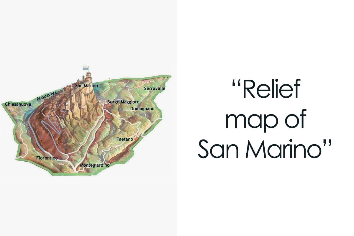
View More Replies...
View more commentsArrow down menu
#36

How Many Firearms Per 100 People In Europe

How Many Firearms Per 100 People In Europe

Dazed_And_MoreBooze Report

Add photo comments
POST
laura_ketteridge avatar
arthbach
Community Member
9 months ago DotsCreated by potrace 1.15, written by Peter Selinger 2001-2017

Compare the level of gun ownership in the Nordic countries with mass shootings. And then look the numbers for the USA.

View More Replies...
View more commentsArrow down menu
#37

The Ten Busiest Port In Europe

The Ten Busiest Port In Europe

Quiet-Luck Report

Add photo comments
POST
mireetta avatar
Remi (He/Him)
Community Member
9 months ago DotsCreated by potrace 1.15, written by Peter Selinger 2001-2017

Should be listed Busiest _Container_ Ports as they're listed by "twenty-foot equivalent unit" which begs to question, why the heck. By tonnage the list would be: Rotterdam, Antwerp, Hamburg, Amsterdam, Algeciras, Marseille, Valencia, Bergen, Trieste and LeHavre

View more commentsArrow down menu
#38

Country Names In Finnish🇫🇮

Country Names In Finnish🇫🇮

Trapziio Report

#39

Percentage Of The Population With Depression

Percentage Of The Population With Depression

viscardvs Report

Add photo comments
POST
ericc_ avatar
Eric C.
Community Member
9 months ago (edited) DotsCreated by potrace 1.15, written by Peter Selinger 2001-2017

...with diagnosed/documented depression. I'd bet the true numbers are much higher...probably double or higher. Depression is still widely seen as taboo to discuss

View More Replies...
View more commentsArrow down menu
#40

Nuclear Power Plants In Europe As Of 21.02.2023

Nuclear Power Plants In Europe As Of 21.02.2023

takenawaybolt Report

#41

The Roman Empire's Border Defenses In 150, By National Geographic

The Roman Empire's Border Defenses In 150, By National Geographic

kyno1 Report

Add photo comments
POST
owenjarvis avatar
Owen
Community Member
9 months ago DotsCreated by potrace 1.15, written by Peter Selinger 2001-2017

I love how the mighty Roman Empire invaded and conquered England and Wales, but when they got to Scotland, they were like 'F**k this, they're trouble, we'll just build a big wall.' As an Englishman, I can confirm that the Scots are hard bastards. Love them.

View More Replies...
View more commentsArrow down menu
#42

Argentine Railway Network In 1990 vs. 2014 🥺

Argentine Railway Network In 1990 vs. 2014 🥺

vinoyporro Report

See Also on Bored Panda
#44

The Countries With The Most Island

The Countries With The Most Island

robertjan88 Report

#45

Anger Map Of Europe

Anger Map Of Europe

Main_Presentation574 Report

#47

How Many Times More Likely Are Black Individuals To Be Imprisoned Compared To White Individuals In The Us?

How Many Times More Likely Are Black Individuals To Be Imprisoned Compared To White Individuals In The Us?

flyingcatwithhorns Report

Add photo comments
POST
nickjackelen avatar
Nick
Community Member
9 months ago DotsCreated by potrace 1.15, written by Peter Selinger 2001-2017

This could be affected by the amount of blacks vs whites in a state

View more commentsArrow down menu
#48

What The Entire World Would Look Like If All The Ice Melted [6376x4840]

What The Entire World Would Look Like If All The Ice Melted [6376x4840]

Empyrealist Report

Add photo comments
POST
randydhuyvetter avatar
Orillion
Community Member
9 months ago DotsCreated by potrace 1.15, written by Peter Selinger 2001-2017

For the people looking for the full size: https://www.nationalgeographic.com/magazine/article/rising-seas-ice-melt-new-shoreline-maps

View More Replies...
View more commentsArrow down menu
#49

The Japanese Empire At Its Height

The Japanese Empire At Its Height

MUNKIESS Report

#50

Real Size Of Saudi Arabia Compared To Parts Of Europe. From Liverpool, Amsterdam, München, Napoli To Barcelona

Real Size Of Saudi Arabia Compared To Parts Of Europe. From Liverpool, Amsterdam, München, Napoli To Barcelona

osmapasgeograficos Report

Add photo comments
POST
j_nieuw avatar
Jayjay
Community Member
9 months ago DotsCreated by potrace 1.15, written by Peter Selinger 2001-2017

What if you compared the number of people living in the same area? And how much of the land is able to sustain life?

View more commentsArrow down menu
#51

What Percentage Of Europeans Trust The News?

What Percentage Of Europeans Trust The News?

JoemamaGia1 Report

Add photo comments
POST
vmblessing avatar
Verena
Community Member
9 months ago DotsCreated by potrace 1.15, written by Peter Selinger 2001-2017

Which type of news? Facebook-News or solid researched news with sources indicated?

View More Replies...
View more commentsArrow down menu
#53

What Parts Of Europe Is Taller Than Møllehøj (Denmark's Highest Peak)?

What Parts Of Europe Is Taller Than Møllehøj (Denmark's Highest Peak)?

JoemamaGia1 Report

Add photo comments
POST
pernillewinkel avatar
Pernille.
Community Member
9 months ago DotsCreated by potrace 1.15, written by Peter Selinger 2001-2017

Even the Netherlands have mountains higher than us. I'm still getting used to living in a place where weather reports in winter says the height above sea level for snow. I've never needed to know that it is snowing at 400m, now I have to go shovel whenever it happens.

View More Replies...
View more commentsArrow down menu
See Also on Bored Panda
#54

Bottled Water Consumption Per Capita In 2019

Bottled Water Consumption Per Capita In 2019

quindiassomigli Report

Add photo comments
POST
vmblessing avatar
Verena
Community Member
9 months ago DotsCreated by potrace 1.15, written by Peter Selinger 2001-2017

Which is hilarious in many countries in the Northwest. In Germany, NL, Belgium and others the tap water is the most controlled "food" item, and it is delivered directly at home. Buying bottled water is simply not necessary

View More Replies...
View more commentsArrow down menu
#55

German Football Clubs Map

German Football Clubs Map

ThunderWolf Report

Add photo comments
POST
naschi avatar
Na Schi
Community Member
9 months ago DotsCreated by potrace 1.15, written by Peter Selinger 2001-2017

I assume this is a map of clubs that play/have played in the top and second (maybe third) league. As this map is definitely missing my village's football club 😁

#56

Situation On December 7th 1949, The Commonly Accepted 'End' Of The Chinese Civil War, When The Roc Capital Was Officially Relocated To Taipei After The Fall Of Chongqing The Week Prior. Despite This, Fighting Would Continue For Years, And The War Never Truly Ended

Situation On December 7th 1949, The Commonly Accepted 'End' Of The Chinese Civil War, When The Roc Capital Was Officially Relocated To Taipei After The Fall Of Chongqing The Week Prior. Despite This, Fighting Would Continue For Years, And The War Never Truly Ended

ThatOneKrazyKaptain Report

#57

Percent Of People In Select Countries Who Are Proud Of Their Country’s Empire

Percent Of People In Select Countries Who Are Proud Of Their Country’s Empire

Flagmaker123 Report

Add photo comments
POST
giovannat1979 avatar
Magazine
Community Member
9 months ago (edited) DotsCreated by potrace 1.15, written by Peter Selinger 2001-2017

The 21% in Italy is very worrying, as our "empire" happened in the fascist era

View More Replies...
View more commentsArrow down menu
#58

This Is What Chatgpt Considers The Most Notable Thing About Each Country In Europe [oc]

This Is What Chatgpt Considers The Most Notable Thing About Each Country In Europe [oc]

naturalbornfox Report

#59

1860's New York City, United States Of America

1860's New York City, United States Of America

MekhaDuk Report

#60

Territories Which Were Never Occupied By Western Powers

Territories Which Were Never Occupied By Western Powers

Frost-Flower Report

#61

Current War Situation In Sudan

Current War Situation In Sudan

Redstream28 Report

#62

Map Showing The Extent Of Earth’s Ice Cap During The Last Glacial Maximum 20,000 Years Ago

Map Showing The Extent Of Earth’s Ice Cap During The Last Glacial Maximum 20,000 Years Ago

Public_Basil_4416 Report

Add photo comments
POST
badulesia-granieri avatar
Badulesia
Community Member
9 months ago DotsCreated by potrace 1.15, written by Peter Selinger 2001-2017

There were also an ice cap in central France (Auvergne). I'm suspicious about the fact that most of Alaska and Siberia are displayed ice free.

View More Replies...
View more commentsArrow down menu
#63

Jus Soli Situation

Jus Soli Situation

quindiassomigli Report

Add photo comments
POST
ericc_ avatar
Eric C.
Community Member
9 months ago (edited) DotsCreated by potrace 1.15, written by Peter Selinger 2001-2017

Jus soli = "right of soil". This is the law/regulation that bestows citizenship to a person based on where they were physically born, regardless the citizenship of the parents

View more commentsArrow down menu
See Also on Bored Panda
#64

New York vs. Los Angeles Size Comparison

New York vs. Los Angeles Size Comparison

dylancatlow Report

Add photo comments
POST
kayrose avatar
Roan The Demon Kitty
Community Member
9 months ago DotsCreated by potrace 1.15, written by Peter Selinger 2001-2017

now put it on top of Tokyo, the size and sprawl of Tokyo and its surrounding metropolitan areas is insanity

View more commentsArrow down menu
#66

Map Of The 1936 U.s Presidential Election During The Height Of Franklin Roosevelt’s Popularity (Wikipedia)

Map Of The 1936 U.s Presidential Election During The Height Of Franklin Roosevelt’s Popularity (Wikipedia)

Randumi Report

Add photo comments
POST
jbunting242 avatar
RabidChild
Community Member
9 months ago DotsCreated by potrace 1.15, written by Peter Selinger 2001-2017

This is pretty funny considering the political landscape in the states these days.Those deep blue areas now would probably label FDR a stupid lib communist/socialist/fascist that wants to steal yer freedums

#67

What People Believe Future Super States Will Be In 1920

What People Believe Future Super States Will Be In 1920

davidliu1007 Report

#68

Most Watched Movies In Zimbabwe In 2015 (By Province)

Most Watched Movies In Zimbabwe In 2015 (By Province)

MepuUyeMakare Report

#69

Parts Of The Country Where Self-Service Gas Pumping Is Illegal (Nj, Or In Counties Over 40k Pop., And In Weymouth, Ma And Huntington, NY)

Parts Of The Country Where Self-Service Gas Pumping Is Illegal (Nj, Or In Counties Over 40k Pop., And In Weymouth, Ma And Huntington, NY)

19neo91 Report

Add photo comments
POST
markwilson_3 avatar
Mark Wilson
Community Member
9 months ago DotsCreated by potrace 1.15, written by Peter Selinger 2001-2017

For those who keep rereading the headline unsuccessfully, it reads: "...(New Jersey, Oregon in counties..."

View more commentsArrow down menu
#70

Silicon Valley In 1982. How Many Of These Companies Survive In 2023?

Silicon Valley In 1982. How Many Of These Companies Survive In 2023?

Shevek99 Report

#71

Map Of The Locations Of The 14 Largest High School Basketball Gyms In The United States

Map Of The Locations Of The 14 Largest High School Basketball Gyms In The United States

Obi2 Report

Add photo comments
POST
markwilson_3 avatar
Mark Wilson
Community Member
9 months ago DotsCreated by potrace 1.15, written by Peter Selinger 2001-2017

College basketball is very important in Indiana, so it's not surprising it has a big effect on high school basketball.

View More Replies...
View more commentsArrow down menu