Get Premium
Dark mode theme is available exclusively for premium users. Learn more about the benefits of subscribing.
No fees, cancel anytime.

 Dark Mode Ad-Free Browsing Unlimited Content
 Ad-Free Browsing Unlimited Content Dark Mode
Join 1.2 million Panda readers who get the best art, memes, and fun stories every week!
At its core, geography is the study of Earth’s landscapes, environments, and the relationships between people and their surroundings. A wholesome enough premise, and the kind of thing you’d expect to bring everyone together over a shared appreciation of how big and interesting the planet is.
And yet it’s also behind some of the most heated arguments known to humanity—from tipsy debates with friends about whether Eurasia is actually one continent or two, all the way up to serious international conflicts over where lines on a map should sit.
Absolute chaos, and exactly why it makes such a rich subject for jokes. The r/geographymemes subreddit collects the best of them, and we’ve pulled together our favorites below.
This post may include affiliate links.
There's a version of this picture/meme including Denmark..In which certain parts situated in the nether regions of a cat's anatomy are squashing Denmark's cat's face/forehead.
For the non-Americans, we were always shown maps of the US with Alaska and Hawaii in a small inset that was on the lower left. (Image in reply.) Alaskans apparently feel that turnabout is fair play...
When geography is not busy dividing people, it is genuinely one of the most fascinating subjects out there. The planet we live on is strange and surprising in ways that most of us never get taught in school, and a lot of what we think we know turns out to be at least a little wrong.
That gap between what people assume and what is actually true is, not coincidentally, also where a lot of the best geography jokes come from.
There is a way bigger meme including greta thunberg. Wanna guess what the caption is?
Take Mount Everest. Most people would confidently tell you it is the tallest mountain on Earth, and they would be technically correct, but only if you measure from sea level. If you measure from base to peak, the title actually belongs to Mauna Kea, a long-dormant volcano in Hawaii.
The reason most people have never heard of it is that around 6,000 meters of it sits underwater in the Pacific Ocean, leaving only about 4,200 meters visible above the surface. Its total height of around 10,200 meters easily beats Everest’s 8,849 meters, it just takes a little more imagination to appreciate.
In the US, they never start teaching other languages until the kids' brains are too fused to learn a new language. A critical failing. Of course, in this day and age, half the population would take up arms if a school tried to teach anything other than English to their ignorant offspring...
And if you really want to put Earth’s mountains in perspective, neither Everest nor Mauna Kea comes close to the tallest mountain in the Solar System. Olympus Mons on Mars stands about 21.9 kilometers tall from base to peak, more than twice the height of Mauna Kea.
There is also a strong case to be made for Rheasilvia, a peak within a crater on the asteroid Vesta, which is thought to reach around 22.5 kilometers high. Earth, it turns out, is not particularly impressive in the mountain department.
Most people’s mental image of the world also turns out to be pretty distorted, and that is largely thanks to the map they grew up looking at. The Mercator projection, which was first developed by Flemish cartographer Gerardus Mercator in 1569, became the global standard for navigation and has been plastered on classroom walls ever since.
The problem is that it wildly distorts the size of landmasses, particularly those far from the equator. On a standard Mercator map, Greenland appears roughly the same size as Africa, when in reality Africa is about 14 times larger. Alaska looks comparable to Australia, when Australia is actually four and a half times as big.
The distortion runs deep enough that some critics have argued it has genuinely shaped how people think about different parts of the world, making countries near the equator look smaller and, by extension, less significant than they actually are.
For a truly accurate map you would essentially need something the size and shape of the Earth itself. There are websites where you can drag countries around and compare their real sizes to each other, and it is genuinely one of the more disorienting things you can do on the internet.
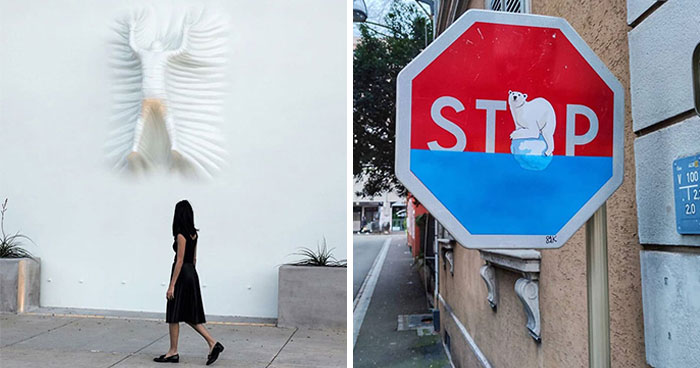
As a Dutch person I find this very funny, but it's not true that we're the only ones who just create more. According to Wikipedia there's around 50 countries that have created extra land. The amount of extra land differs greatly, from 12800 km2 in China to less than 1 km2 in some countries. But there are around 20 countries that have over a 100km2 of newly created land. The Netherlands is second place when it comes to how much land we created (7000km2), but we did create a LOT when it's compared to our small size, I think it's about 1/6th of our total size, or something like that.
The shape of the world is not even fixed, which is something that does not get talked about enough. The continents are constantly moving, pushed around by shifting tectonic plates, and the speed at which they do it is roughly the same rate at which human fingernails grow.
For around 40 million years, North America and Africa drifted apart at about one millimeter per year, right in line with average nail growth, before accelerating to around 20 millimeters a year during a particularly active period 200 million years ago. Your fingernails, in other words, are growing at a pace that has literally reshaped the planet.
Closer to the present, Antarctica is one of the most consistently misunderstood places on the planet. Because it is so bitterly cold, the last thing most people would think to call it is a desert. But that is exactly what it is, and not just any desert. It is the largest one on Earth, covering around 5.5 million square miles.
A desert is scientifically defined as any region that receives very little precipitation, and Antarctica gets so little each year that most of its water is locked inside glaciers and ice sheets rather than falling as rain or snow.
The British isles is easy. Do africa or the balkans next. Edit: Thank you Tom for reminding me. I meant the South of Africa , like the Sub Sahaar region
Whether you came here for the memes or to test your trivia knowledge, hopefully you also walked away having learned something new in the process. The world is a genuinely fascinating place, far more so than most maps or textbooks give it credit for.
All the jokes and debates aside, that is something worth appreciating, and there is plenty more where that came from.
Jesus. I just got finished naming every place and you want me to do it AGAIN?!?
I'm actually impressed. I would have expected far fewer correct results.
I'll take alaska. Wait, this is mercator projection, and Alaska is small
I'm just hoping that all that yellow colouring is nothing to do with any of the bathers ...
I don't think John Lennon was single when that picture was taken.
Even having read John 3, I never expected to see a baby try to go back inside again
Our guide at the Tower of London implied that the UK was not part of Europe. This was in 2001.
I dated a Brit guy who could not understand that, at least geographically (even leaving aside history and culture), the UK is a part of Europe. Guess he thought his puny island was a continent in its own right. The guy definitely wasn't bright.
Load More Replies...I'd like to think that North Europe is painted red just for convenience, but I'd also like to have a pony, and I don't think either of these likes is very likely
I still feel that calling Europe part of Asia misses out some rather important detail. Good to see Australia being counted as a continent, though.


 No fees, cancel anytime


")
")