ADVERTISEMENT

The map might not be the territory, but gosh darn it both aren't fascinating to look at! We’re pretty big fans of maps and we can’t wait to set our eyes on even more unusual and peculiar ones in order to expand our minds and feed our imaginations which are hungry for aesthetic designs. Luckily for us, there are tons of like-minded internet users who are nearly bursting with their love of maps.

This subreddit about maps has nearly 1.5 million members and probably has more creativity than I’ve personally seen anywhere else on Reddit so far. Even though we can’t mention the subreddit’s full name because we'll get censored, the community is truly friendly and has stood the test of time since May 2011. And the person to thank is land surveyor Patrick McGranaghan, the founder of the entire project, whose passion for maps is beyond measure and keeps the online group together.

Patrick and I had a wholesome chat about how to get ourselves moving outside our comfort zones and on adventures, what maps he's recently been working on, as well as the ins and outs of moderating the subreddit.

"I've noticed, especially as I've gotten older, that you only have so much time on this planet and every day that is wasted is a day that you'll never get back. If you want to get out and explore the world you just have to do it. Some adventures will cost time and resources, but the real question I ask myself is can I afford not to do some goal I have my heart set on. There are so many opportunities in this world that it may be hard to choose, but if you wait too long those opportunities will be gone forever," he told Bored Panda to seize the day and really start living.

Bored Panda has featured the subreddit extensively in our previous articles. When you’re done upvoting and commenting on your fave maps in this list, keep in mind that there’s a whole land of adventure waiting for you in these earlier posts right here: Part 1, Part 2, Part 3, and Part 4.

More info: Reddit | Twitter | Tumblr

#1

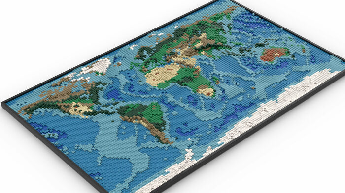
This Is A LEGO World Map I Designed! I Spent Many Hours Staring At Google Earth And Topological Maps To Make This

This Is A LEGO World Map I Designed! I Spent Many Hours Staring At Google Earth And Topological Maps To Make This

GooseWithDaGibus Report

#2

Map Of Africa's Borders If Divided By Languages ​​and Ethnicities

Map Of Africa's Borders If Divided By Languages ​​and Ethnicities

Danielbrenim Report

Add photo comments
POST
superstuffs avatar
Marny
Community Member
2 years ago DotsCreated by potrace 1.15, written by Peter Selinger 2001-2017

One of the terrible harms of colonialism was in drawing borders that utterly disregarded these connections among people and created terrible unnecessary conflict. (Just like Catalonia in Spain, etc. but on a much greater scale.)

View More Replies...
View more commentsArrow down menu
#3

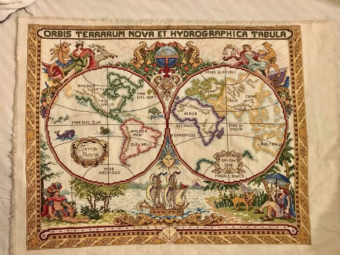
Hello! I Was Told You Would Enjoy This- Took Me 3 Years!

Hello! I Was Told You Would Enjoy This- Took Me 3 Years!

avalonal5464 Report

I was interested to hear about Patrick's recent cartography projects as well. He told me that recently he's been focusing on pixel maps which are bound to get some of you Pandas nostalgic. "This spring, I was making a lot of pixel maps that looked like old video game graphics. I picked some exotic places like Botswana and Mongolia to make these maps," he shared with Bored Panda.

"I think a great way to learn about an exotic place is to make a map of it and really give some hours and care into making the map look as good as possible. You really get a connection for a place as you're putting labels on and making decisions about what to include and where to lay everything out."

#5

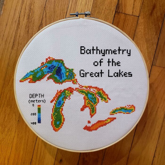
Hello! I Cross Stitch Earth Science Maps And Have Been Told They Belong Here. Great Lakes Bathymetry Is My Favorite So Far

Hello! I Cross Stitch Earth Science Maps And Have Been Told They Belong Here. Great Lakes Bathymetry Is My Favorite So Far

blondeboxshell Report

Add photo comments
POST
nfrlprdpr avatar
Mazer
Community Member
2 years ago DotsCreated by potrace 1.15, written by Peter Selinger 2001-2017

Excellent, excellent, excellent!! I can thank Covid for getting me in deep into the geology world!

View more commentsArrow down menu
ADVERTISEMENT
#6

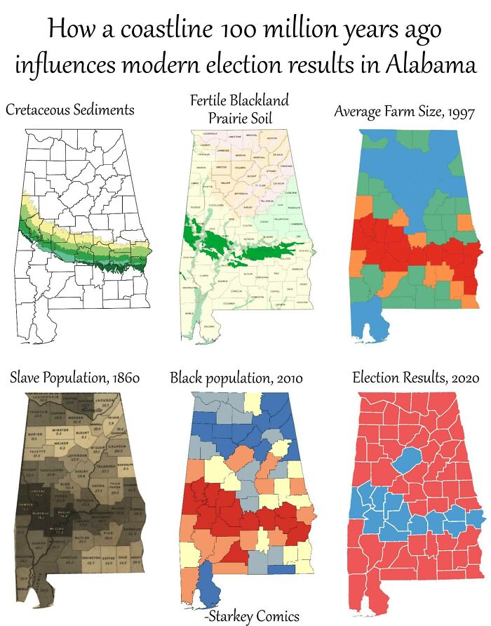
How A Coastline 100 Million Years Ago Influences Modern Election Results In Alabama

How A Coastline 100 Million Years Ago Influences Modern Election Results In Alabama

IamShartacus Report

Add photo comments
POST
roxy_eastland avatar
Roxy Eastland
Community Member
2 years ago DotsCreated by potrace 1.15, written by Peter Selinger 2001-2017

Now I want to know what caused the sediments to be laid down in this pattern to start with. We need to go back further.

View More Replies...
View more commentsArrow down menu

As for moderating the subreddit, which continues growing, it's always been about finding the right balance. Patrick also told me that moderating things, just like doing anything in life, means that there will always be someone who's unhappy with your decisions.

"Moderating is always a delicate balance. It is impossible to please everybody. If you are too laissez-faire you get a lot of low effort and ugly submissions and the users complain. If you are too strict, then you risk alienating those who supply the content for the sub. I try to find a balance between these two extremes. Overall, I'm satisfied with the moderating and I don't foresee any changes in the immediate future," he said.

As for the future? Patrick's finally traveling to Europe again and plans to have a grand old time in Italy soon.

#7

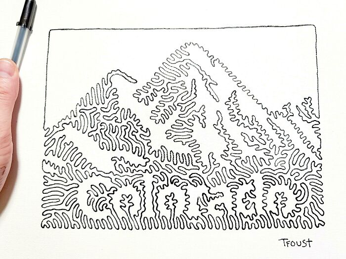
I Am Working On A Picture Book With Each State Drawn With One Line. I Finished My 7th State Last Night

I Am Working On A Picture Book With Each State Drawn With One Line. I Finished My 7th State Last Night

tfoust10 Report

Add photo comments
POST
goodmiffy avatar
Fish Boden
Community Member
2 years ago DotsCreated by potrace 1.15, written by Peter Selinger 2001-2017

Does anyone else find it easier to read the word whilst actively scrolling?

View More Replies...
View more commentsArrow down menu
#8

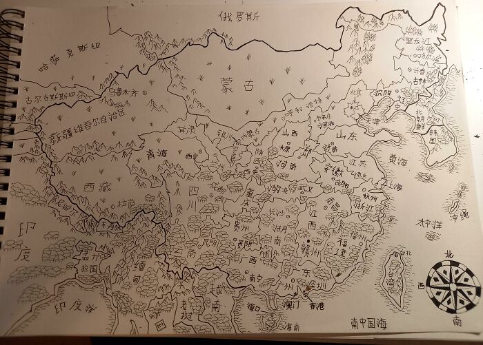
Hand Drawn Map Of China And Neighboring Countries With Placenames In Mandarin (I Drew It As An Exercise To Memorise All The Provinces)

Hand Drawn Map Of China And Neighboring Countries With Placenames In Mandarin (I Drew It As An Exercise To Memorise All The Provinces)

LuKing-Ra Report

ADVERTISEMENT
#9

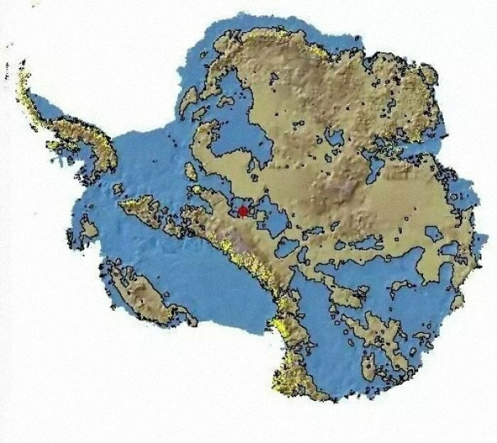
Antarctica Without Ice, U Don't See That A Lot

Antarctica Without Ice, U Don't See That A Lot

Rajni_Rao Report

Add photo comments
POST
dirigobill avatar
crisbarriuso avatar
Miss Cris
Community Member
2 years ago (edited) DotsCreated by potrace 1.15, written by Peter Selinger 2001-2017

That red spot is superman, you can see him from the space.

markus_holstein90 avatar
Markus Holstein
Community Member
2 years ago DotsCreated by potrace 1.15, written by Peter Selinger 2001-2017

How do we actually know this? Ground-penetrating radar? Some kind of infrared radiation or something?

wbrameld4 avatar
Walter Brameld
Community Member
2 years ago DotsCreated by potrace 1.15, written by Peter Selinger 2001-2017

I think the land would rise up a bit with all that weight removed. So this probably isn't completely accurate.

reynard99a avatar
Reynard
Community Member
2 years ago DotsCreated by potrace 1.15, written by Peter Selinger 2001-2017

Yep, isostatic rebound. It's still happening to the crust in the Northern Hemispere from the last glacial period. The Hudson Bay region of Canada is rebounding at an astounding rate of over 1.25cm per year.

Load More Replies...
nfrlprdpr avatar
Mazer
Community Member
2 years ago DotsCreated by potrace 1.15, written by Peter Selinger 2001-2017

Wow. Still one of the most unique places on the face of the earth!

6bean80 avatar
tmw
Community Member
2 years ago DotsCreated by potrace 1.15, written by Peter Selinger 2001-2017

this is very interesting. the land formations look very different. it took me a minute. but there are no rivers. the bodies of water don't join up and flow out like they would if there was rain and freeze/thaw cycle that led to run-off. that is really neat.

sawdust99 avatar
Sawdust
Community Member
2 years ago DotsCreated by potrace 1.15, written by Peter Selinger 2001-2017

Wow, Antarctica without ice is like an owl without its feathers.

benjamintang08 avatar
Benjamin Tang
Community Member
2 years ago DotsCreated by potrace 1.15, written by Peter Selinger 2001-2017

Antarctica's lakes and gulfs make it seem so much more interesting.

jimmypop2001 avatar
jimmy pop
Community Member
2 years ago DotsCreated by potrace 1.15, written by Peter Selinger 2001-2017

Does this account for the risen sea level due to all the molten ice or is this based on current sea levels?

ericahales avatar
ZooMom
Community Member
2 years ago DotsCreated by potrace 1.15, written by Peter Selinger 2001-2017

Incredible that I never realized how the actual land was. I’m my mind it’s just one solid piece

View More Replies...
View more commentsArrow down menu

Previously, I had a couple of in-depth chats with Patrick, the founder of the subreddit, about the project, learning to navigate better, and the state of travel during the pandemic. In the decade since its founding, the subreddit has blossomed into a welcoming niche for cartographers—professional and amateur alike—all over the globe. Everyone’s welcome, so long as they stick to the rules and stay polite. Patrick developed his love for maps very early in his childhood as his family traveled and moved a lot.

ADVERTISEMENT

"The older I get, the more I realize that spatial awareness just comes naturally to some people, and for others, it's a struggle," Patrick pointed out to Bored Panda that just like with any other skill, getting good at navigating requires patience, dedication, and repetition.

“In a way, reliance on Google Maps has made us dumber. We let the navigation app do all the work for us and don't engage with making the decisions," he said.

#10

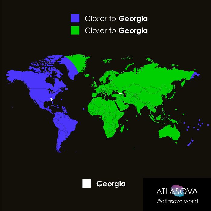
Are You Closer To Georgia, Or To Georgia?

Are You Closer To Georgia, Or To Georgia?

atlasova Report

#11

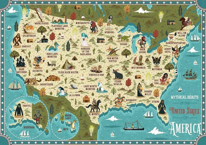
Mythical Beasts Of The United States Of America

Mythical Beasts Of The United States Of America

NeilParkinsonMakes Report

#12

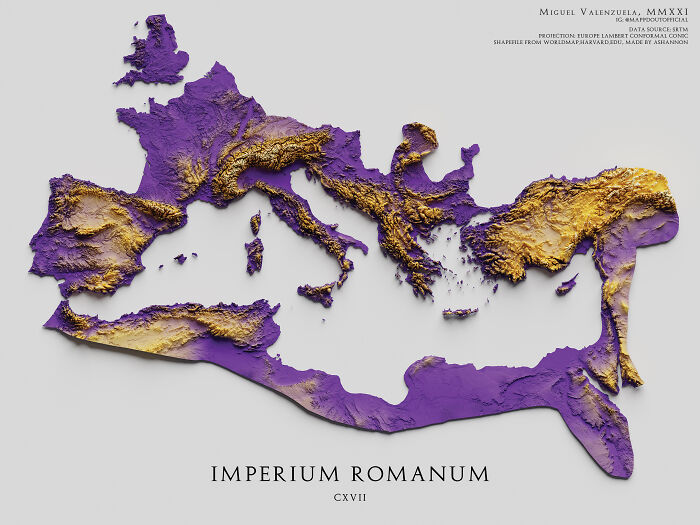
The Topography Of The Roman Empire, Ad 117

The Topography Of The Roman Empire, Ad 117

boytutoy Report

"If you live in a place with a tall hill or some viewpoint, go up there some time and look around. Try to identify as many landmarks as you can. Notice where they are in relation to each other. Look for new landmarks that you've never noticed before and keep them in mind as you navigate your hometown. If there are rivers or other features that cause chokepoints on bridges or highways, memorize all the bridges and where they go. In this way, you'll know the layout of your city and how to get around," the subreddit’s founder, Patrick, gave us some pointers on how to up our navigation game.

ADVERTISEMENT

With mass vaccination programs continuing to gather steam, global travel and adventure are nonetheless still in a very confusing situation right now. On the one hand, lockdowns had ended in some countries (and in the case of the United Kingdom will end on ‘Freedom Day’ on July 19, though with some confusion over mask-wearing going forth).

However, the quick rise in new cases after ending restrictions (e.g. in the Netherlands where cases soared by a whopping 500%), along with the continued spread of the Delta variant of Covid-19, mean that these same regulations are returning. And the rules keep changing very quickly, so it’s a nightmare to follow if you’re traveling, even if you’re double-vaxxed and immune.

#13

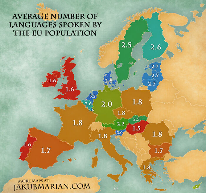
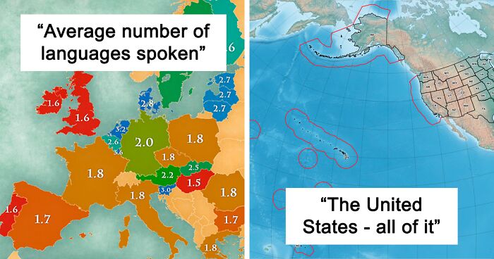
Average Number Of Languages Spoken By The EU Population

Average Number Of Languages Spoken By The EU Population

JeannaLeavy Report

Add photo comments
POST
roxy_eastland avatar
Roxy Eastland
Community Member
2 years ago DotsCreated by potrace 1.15, written by Peter Selinger 2001-2017

The extra 0.6 in the UK is definitely from immigrant families and their descendants, plus those Brits that continue to use Welsh/Gaelic/Irish after school. The average indigenous Brit doesn't speak more than English with anything approaching fluency.

View More Replies...
View more commentsArrow down menu
#15

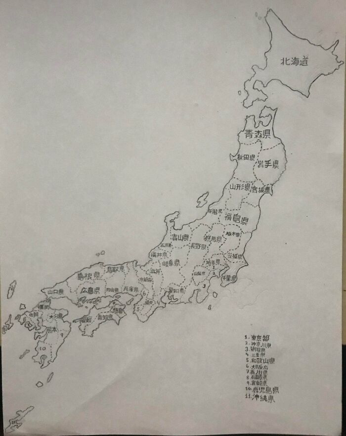
I Drew A Map Of All Japanese Prefectures (Took 6 Hours). Hope You Like It

I Drew A Map Of All Japanese Prefectures (Took 6 Hours). Hope You Like It

GoroMajimaKun Report

“I think we all have to take precautions, get vaccinated, and avoid risky behaviors. That said, I think we need to remember that we're fighting to eradicate this disease and get back to a normal state of affairs. I really miss the freedom of travel. We're losing years of potential happiness to the lockdowns and at some point, we need to open up. Those are issues above my pay grade though and I hope it's sooner rather than later," Patrick told me in late spring.

ADVERTISEMENT

According to Patrick, who makes maps for a living, he’s heard tons of people say that everything has already been mapped. However, he points out that there will always be a need for new maps as time goes by.

"People say, 'Hasn't everything been mapped?' The world is constantly changing and accurate spatial data is a fleeting thing. Google Maps certainly gives the impression that everything is mapped, but there is selection and generalization in their data," he said.

#16

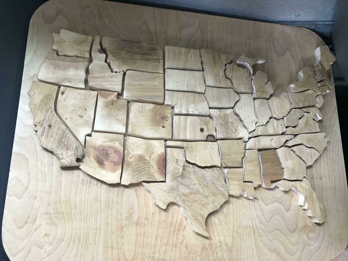
This Is My Friends Wood Shop Project, Thought It Would Be Fitting Here

This Is My Friends Wood Shop Project, Thought It Would Be Fitting Here

Fleebo-1 Report

#18

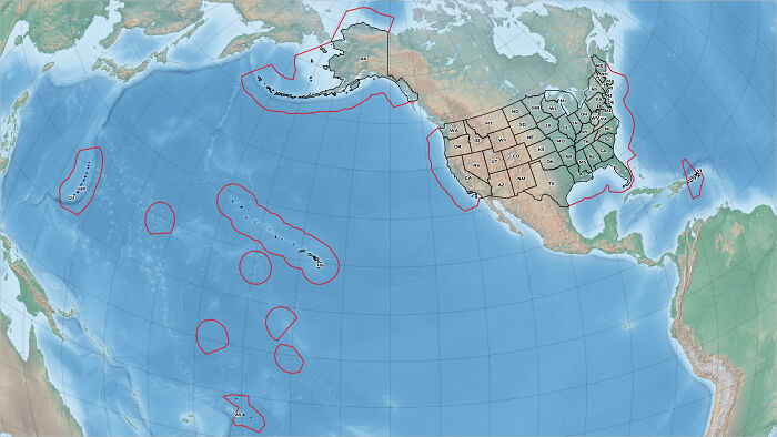
The United States — All Of It

The United States — All Of It

guspolly3 Report

Add photo comments
POST
junkmailspam avatar
An Co
Community Member
2 years ago DotsCreated by potrace 1.15, written by Peter Selinger 2001-2017

Samoans get screwed the worst. Huge population born in American Territory (just like Guam and Puerto Rico), but not given citizenship. (Guam, PR get it.)

View More Replies...
View more commentsArrow down menu

"Infrastructure is a key thing that we all rely on and don't realize it. The electricity to turn on your lights, the fiber that carries this message, the water that you drink. All those things are traveling to you above and below ground. Construction is constantly happening along this route. Knowing where to safely build is critical,” Patrick told Bored Panda about the need to map and remap the world that surrounds us.

"There are other themes that have spatial data too. Municipalities pass zoning and other restrictions all the time. Cities like London have an umbrella of rules about the preservation of old buildings, view-lines, noise nuisances, and other regulations. Making accurate maps is a constant struggle that is going to stay with us for a long time. As more things get built, knowing where these are located is important. Maintaining the world's databases of spatial information is the task of the modern map-maker." There will always be a need for maps and, we hope, for the entire subreddit as well.

ADVERTISEMENT
#20

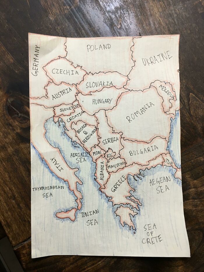
My Son’s (12) Map Of The Balkans

My Son’s (12) Map Of The Balkans

Lindadorse Report

Add photo comments
POST
ner_diz avatar
Serial pacifist
Community Member
2 years ago DotsCreated by potrace 1.15, written by Peter Selinger 2001-2017

Speaking as a guy from the region, great job (My country's name has a tiny spelling error, but let's not make a fuss about it :-) ).

View More Replies...
View more commentsArrow down menu
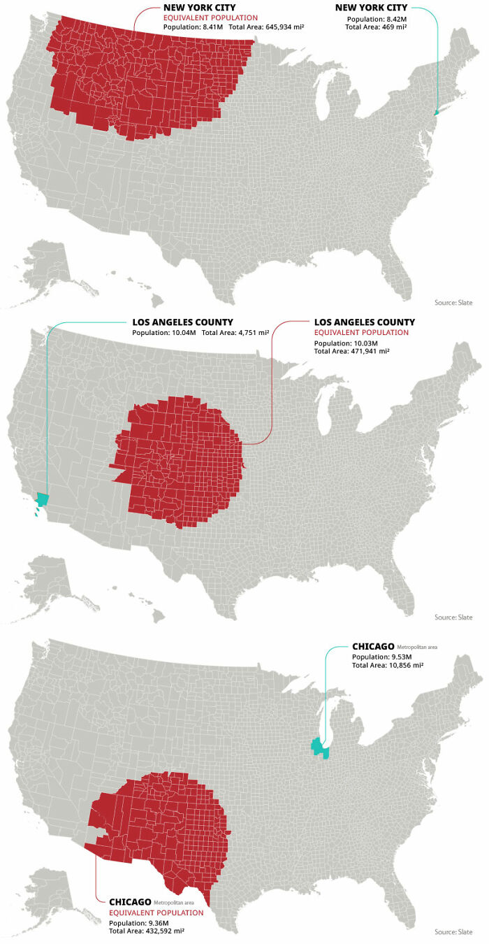
#21

Rural Equivalent Of New York City, Los Angeles And Chicago

Rural Equivalent Of New York City, Los Angeles And Chicago

kapowitz9 Report

Add photo comments
POST
chrisb_5 avatar
Chris B
Community Member
2 years ago DotsCreated by potrace 1.15, written by Peter Selinger 2001-2017

Okay. This is impressive. Very impressive. Haven't thought it would be so... well... impressive.

View More Replies...
View more commentsArrow down menu
#22

Children’s Map Of The World (Only Shows Countries Where Smacking Children Is Illegal)

Children’s Map Of The World (Only Shows Countries Where Smacking Children Is Illegal)

OwlRepair Report

#23

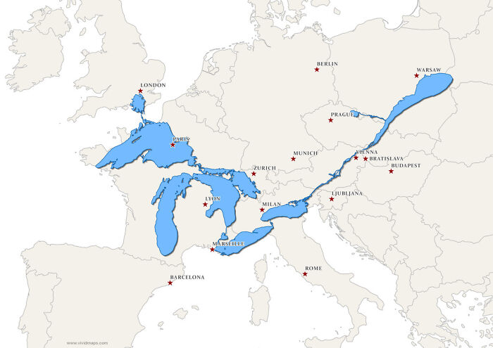
The Great Lakes And Saint Lawrence River Superimposed On A Map Of Europe

The Great Lakes And Saint Lawrence River Superimposed On A Map Of Europe

fraterkretert43 Report

#24

Why Is [country]...? - Google Autocomplete Results (European Countires, 2021)

Why Is [country]...? - Google Autocomplete Results (European Countires, 2021)

Morwon Report

#26

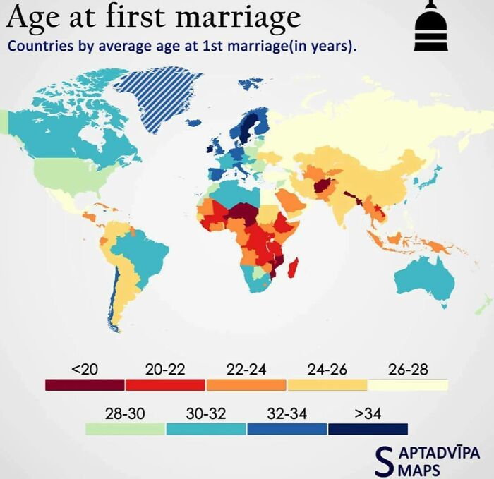
Age At First Marriage

Age At First Marriage

latecomer11 Report

#27

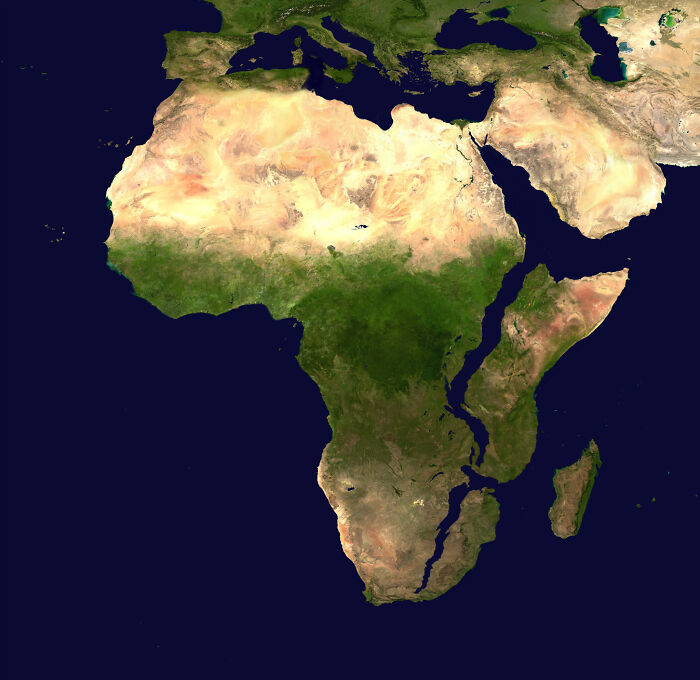
Africa, 10 Million Years Later. (Based On Current Predictions And Data)

Africa, 10 Million Years Later. (Based On Current Predictions And Data)

TheAssConsumer Report

#28

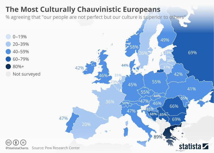
The Most Culturally Chauvinistic Europeans

The Most Culturally Chauvinistic Europeans

tiredeggy Report

#29

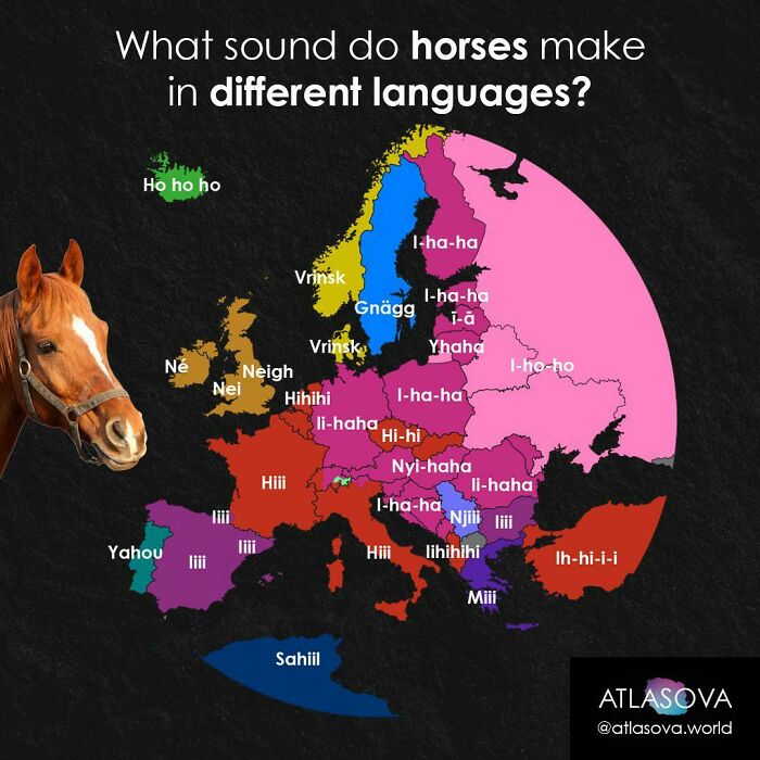
What Does A Horse Say In Your Language?

What Does A Horse Say In Your Language?

atlasova Report

#30

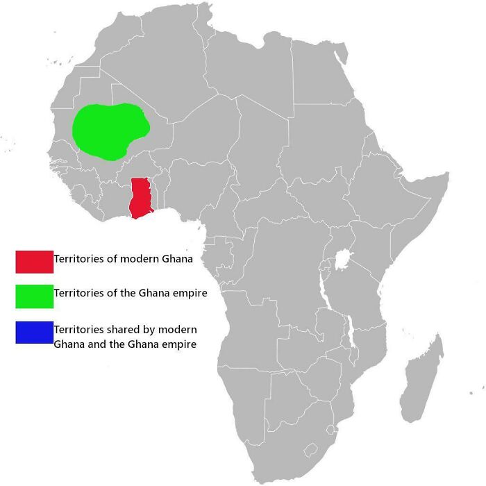
Territories Of Modern Ghana And Ghana Empire

Territories Of Modern Ghana And Ghana Empire

logatwork Report

#31

The Topography Of Africa

The Topography Of Africa

eastofnowhereco Report

Add photo comments
POST
crisbarriuso avatar
Miss Cris
Community Member
2 years ago DotsCreated by potrace 1.15, written by Peter Selinger 2001-2017

Now you can understand better the map of Africa in 100 milions years :)

View more commentsArrow down menu
#32

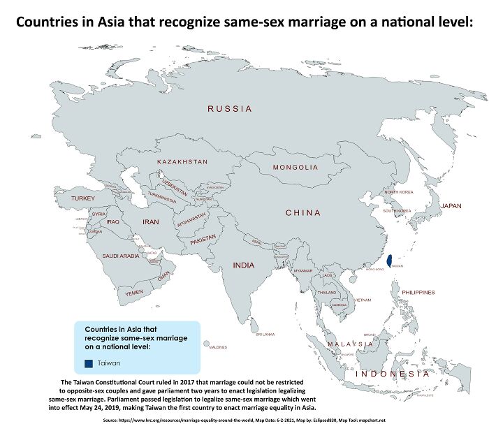
Pride Month Map: Countries In Asia That Recognize Same-Sex Marriage On A National Level

Pride Month Map: Countries In Asia That Recognize Same-Sex Marriage On A National Level

Eclipsed830 Report

#33

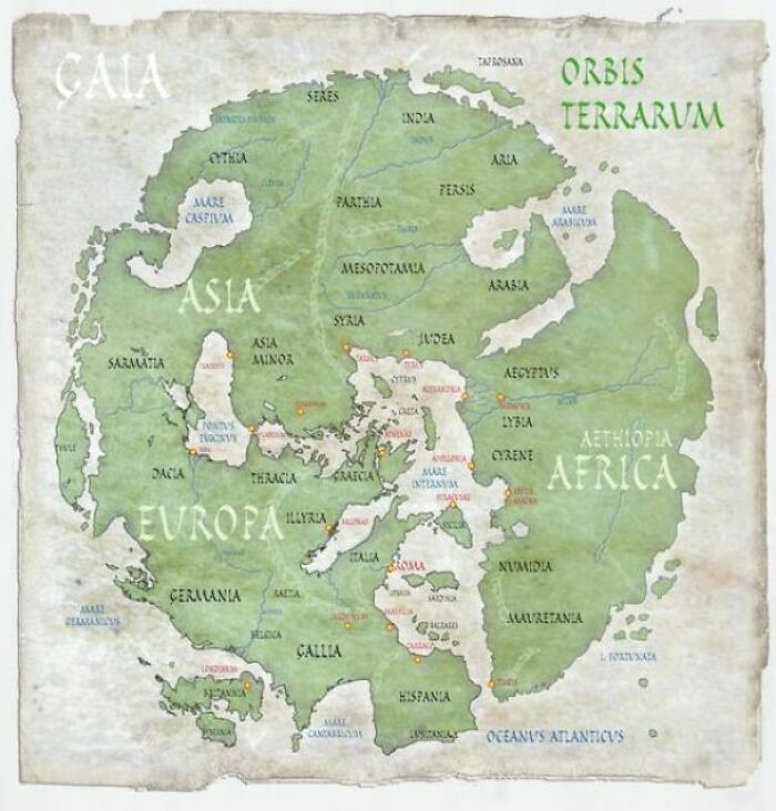
Map Of The Ancient Roman World From Their Perspective, 43 AD

Map Of The Ancient Roman World From Their Perspective, 43 AD

Subhigh42 Report

#34

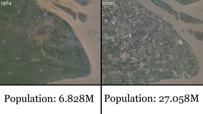
Shanghai, China From 1984-2020

Shanghai, China From 1984-2020

dmoney1300 Report

Add photo comments
POST
nfrlprdpr avatar
Mazer
Community Member
2 years ago DotsCreated by potrace 1.15, written by Peter Selinger 2001-2017

Heartbreaking that we have displaced so many plant and animal populations.

View More Replies...
View more commentsArrow down menu
#35

The Pacific Is Bigger Than All The Land In The World Combined

The Pacific Is Bigger Than All The Land In The World Combined

F4310_3M Report

Add photo comments
POST
nfrlprdpr avatar
Mazer
Community Member
2 years ago DotsCreated by potrace 1.15, written by Peter Selinger 2001-2017

Give it a couple million years the Atlantic is going to catch up!

View more commentsArrow down menu
#36

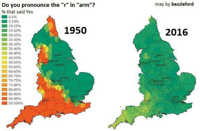
“Do You Pronounce The ‘R’ In ‘Arm’?” - England 1950 vs. 2016

“Do You Pronounce The ‘R’ In ‘Arm’?” - England 1950 vs. 2016

Schwarzwaldmilch Report

#38

This Is What The Surface Of Mars Would Look Like If, Like Earth, 71% Of Its Surface Area Was Covered With Water

This Is What The Surface Of Mars Would Look Like If, Like Earth, 71% Of Its Surface Area Was Covered With Water

RespectTheFancy Report

#39

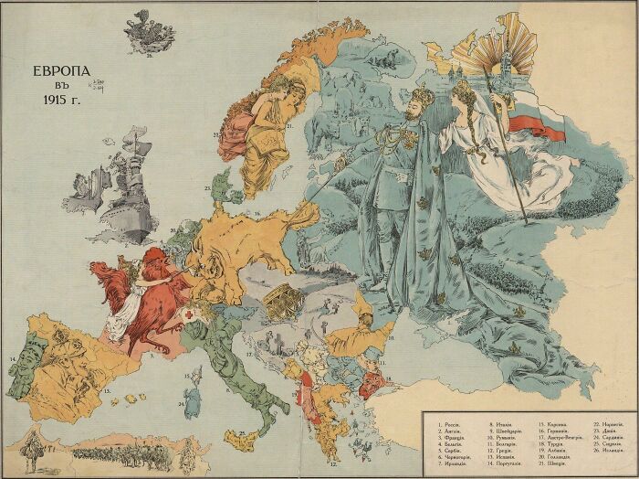
Russian Propaganda Map Of Europe In 1915

Russian Propaganda Map Of Europe In 1915

Ivan_Krasnov Report

Add photo comments
POST
anne_juergens avatar
I’m A Black Cat
Community Member
2 years ago DotsCreated by potrace 1.15, written by Peter Selinger 2001-2017

This is actually great artistic work, if you set aside the imperialistic nature

View more commentsArrow down menu
#40

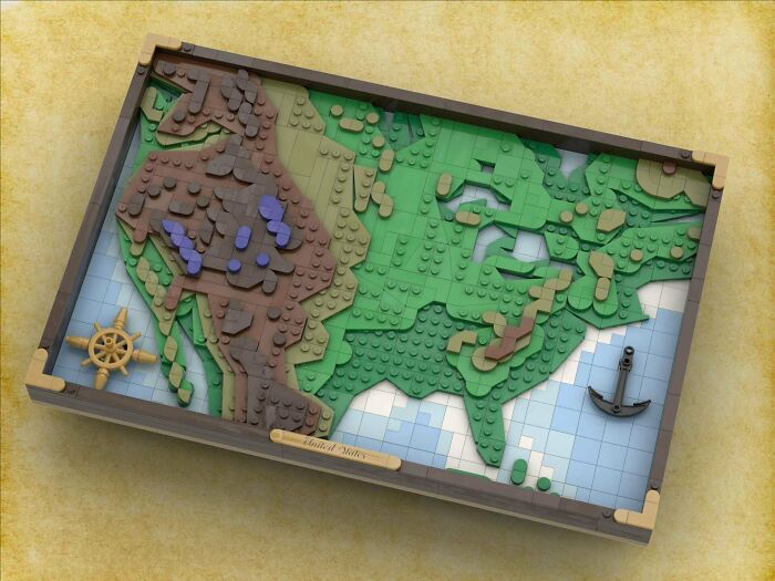
My Latest LEGO Topographical Map, This Time The USA (Including Parts Of Canada And Mexico)

My Latest LEGO Topographical Map, This Time The USA (Including Parts Of Canada And Mexico)

kc_sharky Report

#41

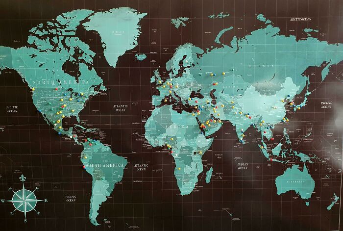
For 6.5 Years My Wife And I Tried To Have Every Person Or Family Who Visited Our Home Put A Pin In This Map, Marking Where They Called, Or Once Called, Home. We're Moving Out Now, And Decided To Tally Up This Phase Of Our Lives. 48 Countries. 15 States. 142 Pins

For 6.5 Years My Wife And I Tried To Have Every Person Or Family Who Visited Our Home Put A Pin In This Map, Marking Where They Called, Or Once Called, Home. We're Moving Out Now, And Decided To Tally Up This Phase Of Our Lives. 48 Countries. 15 States. 142 Pins

iammandalore Report

#42

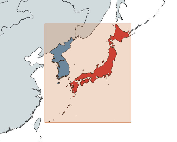
Japan Is Farther East, West, North And South Than Korea

Japan Is Farther East, West, North And South Than Korea

poktanju Report

Add photo comments
POST
nfrlprdpr avatar
Mazer
Community Member
2 years ago (edited) DotsCreated by potrace 1.15, written by Peter Selinger 2001-2017

So there!!! It’s also one of the most rapidly moving land masses on our planet, Thanks to there being for tectonic plates running either through and/or near Japan

View more commentsArrow down menu
#43

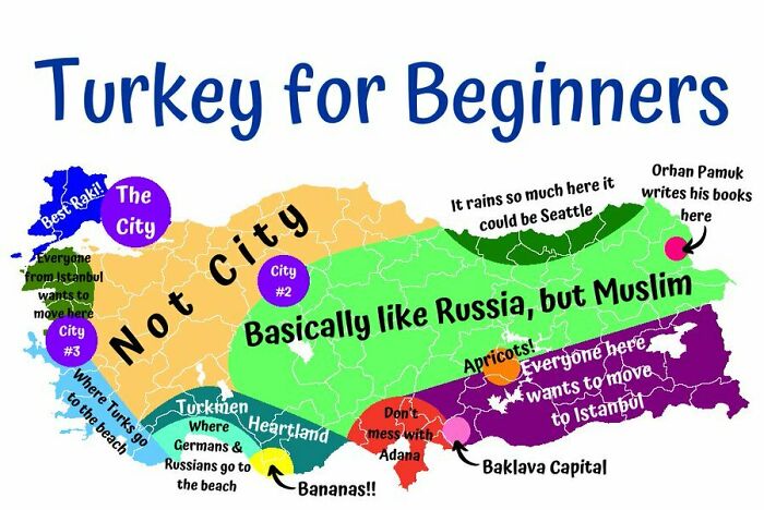
Turkey For Beginners

Turkey For Beginners

reddit.com Report

Add photo comments
POST
ca avatar
C A
Community Member
2 years ago DotsCreated by potrace 1.15, written by Peter Selinger 2001-2017

This is funny and relatable. If everyone described their country like this it would be interesting!

View more commentsArrow down menu
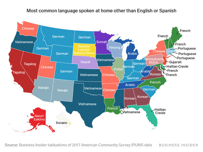
#45

Most Spoken Languages In Each US State Other Than English Or Spanish

Most Spoken Languages In Each US State Other Than English Or Spanish

TurtleMaster69_ Report

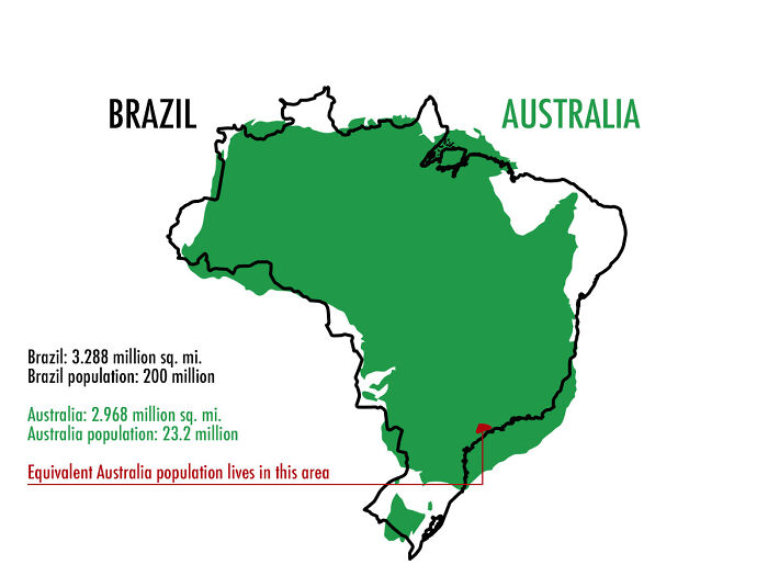
#46

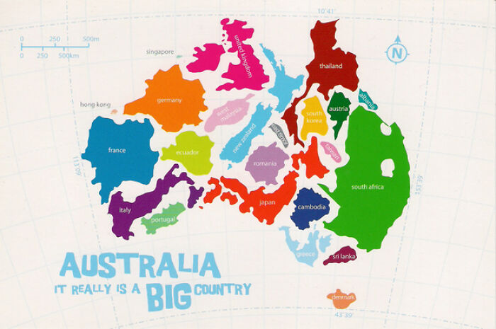
Australia And Brazil Comparison

Australia And Brazil Comparison

World-Tight Report

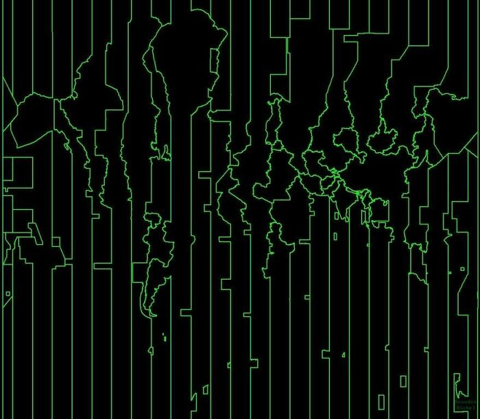
#47

A Map Of The World But It’s Just The Time Zones

A Map Of The World But It’s Just The Time Zones

GeneviveStarks Report

Add photo comments
POST
guhanpc avatar
JustAPanda
Community Member
2 years ago DotsCreated by potrace 1.15, written by Peter Selinger 2001-2017

Looks like a coding part with 1s and 0s from the movies except with lines

View more commentsArrow down menu
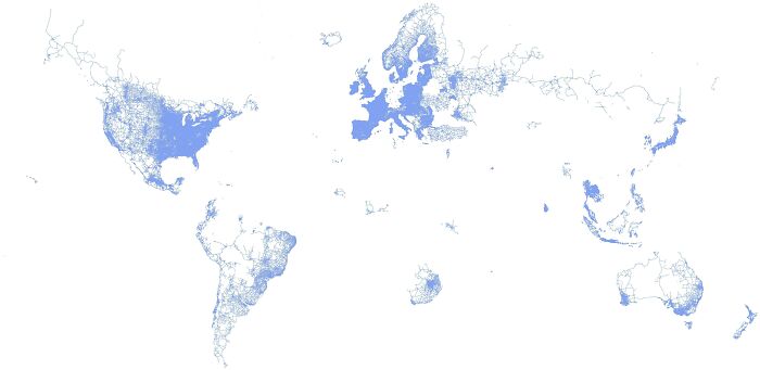
#48

The World According To Google Street View

The World According To Google Street View

wetterg8iuk Report

#49

The Most Consumed Type Of Alcoholic Drink In Europe

The Most Consumed Type Of Alcoholic Drink In Europe

Landgeist Report

#50

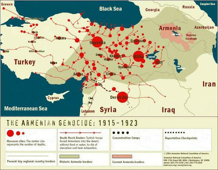
Map Of The Armenian Genocide. The Size Of The Red Circle Represents The Number Of People Killed

Map Of The Armenian Genocide. The Size Of The Red Circle Represents The Number Of People Killed

No_Chip2111 Report

#51

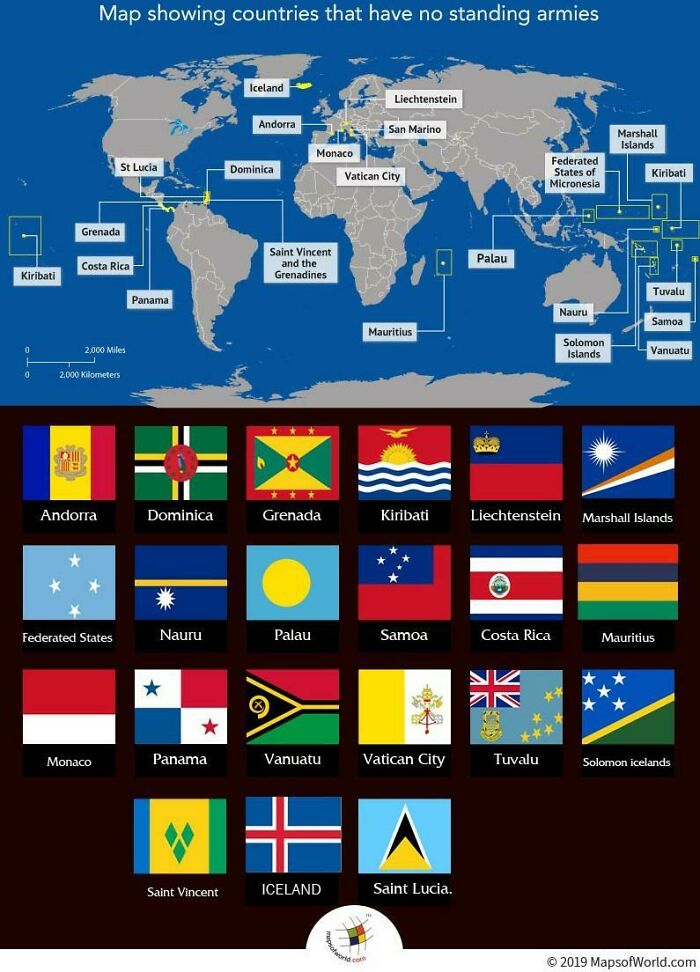
These Countries Do Not Have An Army

These Countries Do Not Have An Army

MeronDC Report

Add photo comments
POST
laurencaswell4 avatar
Lauren Caswell
Community Member
2 years ago DotsCreated by potrace 1.15, written by Peter Selinger 2001-2017

Many of the Pacific nations are 'guarded' ie the armies of nz and australia, and the governments, have a close relationship and are allies. It makes sense

View more commentsArrow down menu
#52

My Primary Map Stitching Project Has Been State Bedrock Geology Maps. Georgia Is The 17th State I've Finished!

My Primary Map Stitching Project Has Been State Bedrock Geology Maps. Georgia Is The 17th State I've Finished!

blondeboxshell Report

#53

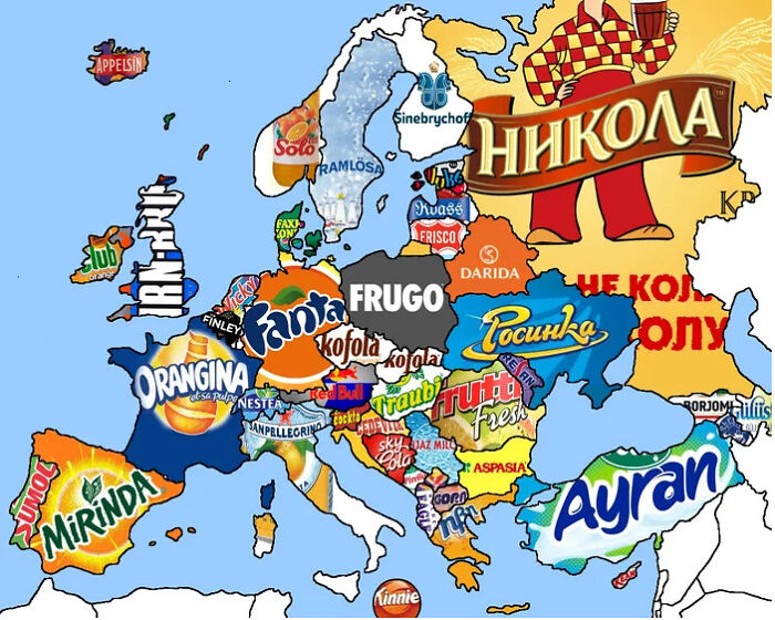
Soft Drinks From All Over Europe

Soft Drinks From All Over Europe

klaci03 Report

Add photo comments
POST
juliajuhas avatar
JuJu
Community Member
2 years ago DotsCreated by potrace 1.15, written by Peter Selinger 2001-2017

Orangina is my fav. I loved it on holidays as a child and now I can but it at home.

View More Replies...
View more commentsArrow down menu
#54

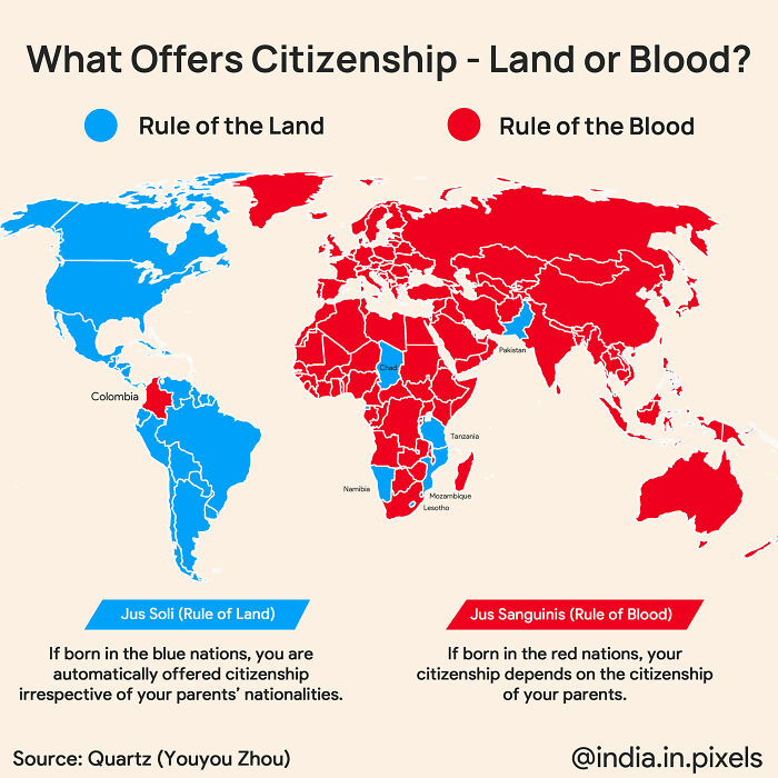
Places Where Birthright Citizenship Is Based On Land And Places Where It Is Based On Blood

Places Where Birthright Citizenship Is Based On Land And Places Where It Is Based On Blood

constantlyhere100 Report

Add photo comments
POST
ner_diz avatar
Serial pacifist
Community Member
2 years ago DotsCreated by potrace 1.15, written by Peter Selinger 2001-2017

Ummmm, this is not quite correct. I live in a country that's designated red, but in reality, it is blue.

View More Replies...
View more commentsArrow down menu
#55

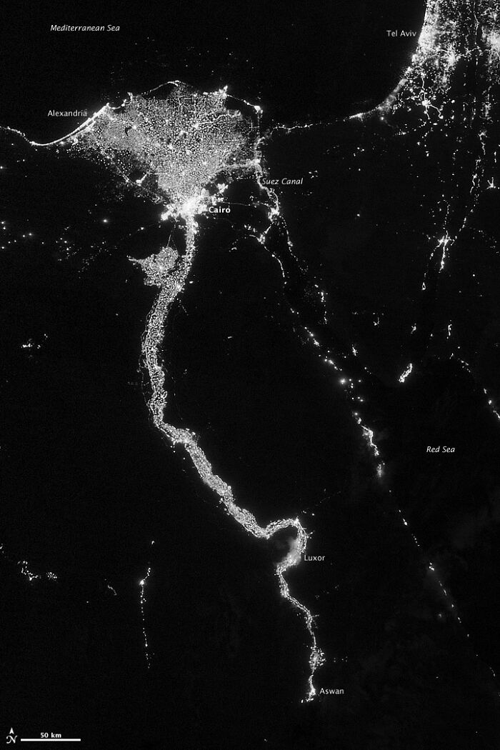
Egypt's Population Concentrated Around The Nile River

Egypt's Population Concentrated Around The Nile River

MeronDC Report

#57

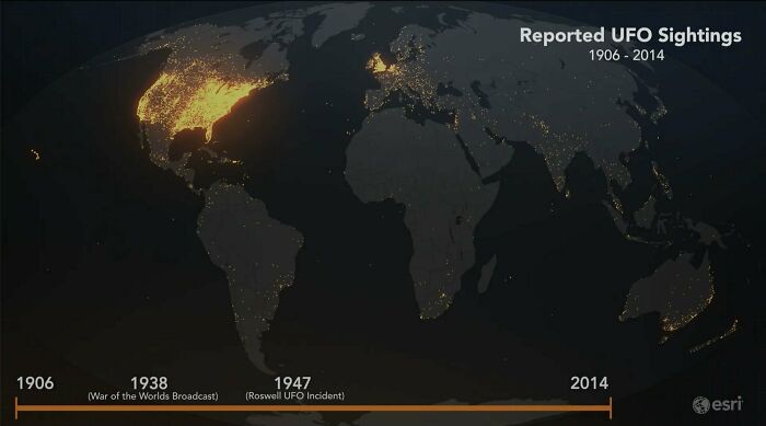
This Is A Map Of All Reported UFO Sightings, 1906-2014 (Source:esri)

This Is A Map Of All Reported UFO Sightings, 1906-2014 (Source:esri)

reddit.com Report

#58

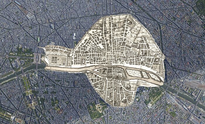
1422 Paris Map On Top Of Today Paris

1422 Paris Map On Top Of Today Paris

MikebibbyoverMJ Report

Add photo comments
POST
#59

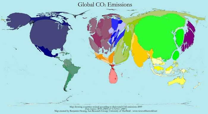
A World Map, But Countries Are Sized According To Their Co2 Emissions (2010)

A World Map, But Countries Are Sized According To Their Co2 Emissions (2010)

imenaupwas Report

Add photo comments
POST
hasilefisile avatar
ProfessionalTimeWaster
Community Member
2 years ago DotsCreated by potrace 1.15, written by Peter Selinger 2001-2017

CO2 emissions per capita matters more. Qatar, Kuwait, UAE are bigger emitters than USA and China.

View More Replies...
View more commentsArrow down menu
#60

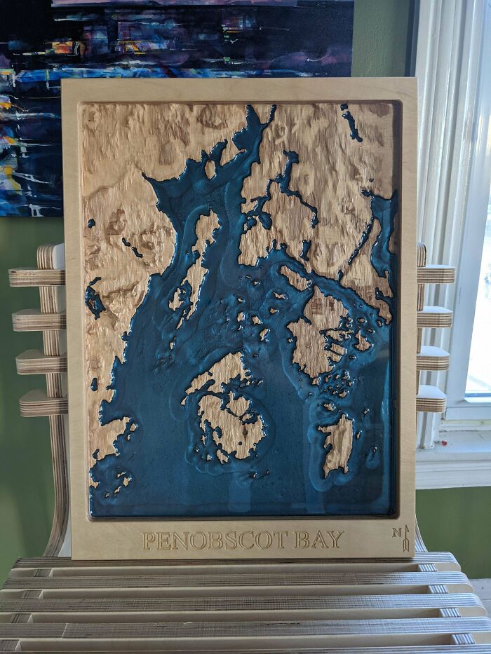
I Made A 3D Topographic Map Of Penobscot Bay, Off The Coast Of Maine

I Made A 3D Topographic Map Of Penobscot Bay, Off The Coast Of Maine

mtbsnow Report

#61

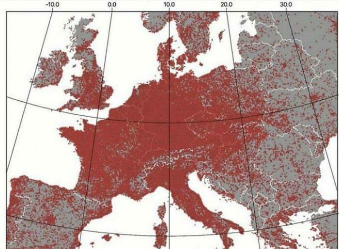
Every Dot Is A Football (Soccer) Pitch

Every Dot Is A Football (Soccer) Pitch

lukedawson199p Report

#62

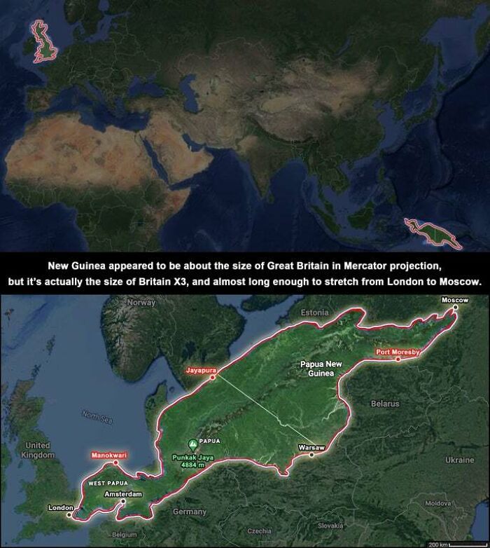
New Guinea. I Had No Idea It Was So Large

New Guinea. I Had No Idea It Was So Large

fviegasAgdt3467 Report

#63

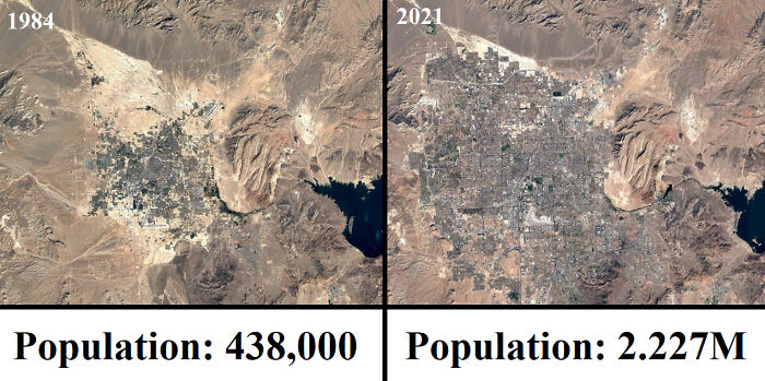
Las Vegas From 1984-2021

Las Vegas From 1984-2021

BeaverTheCuber777 Report

#64

A Map Of What's Happening In Israel-Palestine Right Now. Please Be Gentle In The Comments, It's A Mess In Here (Lynchings And Rockets And Riots And Firefights And Military Lockdowns, Jesus)

A Map Of What's Happening In Israel-Palestine Right Now. Please Be Gentle In The Comments, It's A Mess In Here (Lynchings And Rockets And Riots And Firefights And Military Lockdowns, Jesus)

Spiritual-Panda-1805 Report

#65

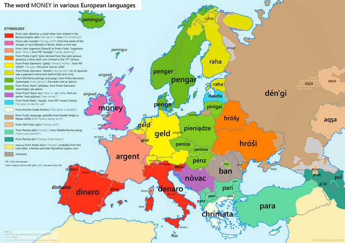
The Word Money In Various European Languages

The Word Money In Various European Languages

klaci03 Report

Add photo comments
POST
giulia-arrigoni21 avatar
Emmydearest
Community Member
2 years ago DotsCreated by potrace 1.15, written by Peter Selinger 2001-2017

In Italy we don't use "denaro" on daily basis conversations. We usually say "soldi". "Denaro" is more formal, I guess. Or technical: denaro pubblico, denaro liquido, pagamento in denaro...

View More Replies...
View more commentsArrow down menu
#66

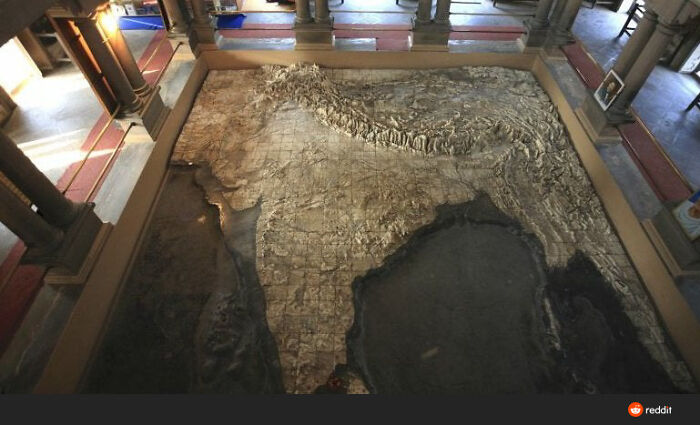
A Physical Map Of India At The Bharat Mata Temple, Varanasi, India

A Physical Map Of India At The Bharat Mata Temple, Varanasi, India

MissusWeaver Report

See Also on Bored Panda
#67

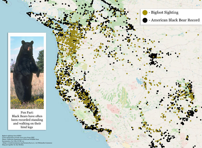
Bigfoot Sightings vs. Black Bear Records

Bigfoot Sightings vs. Black Bear Records

oefiefieuwbe Report

Add photo comments
POST
ner_diz avatar
Serial pacifist
Community Member
2 years ago DotsCreated by potrace 1.15, written by Peter Selinger 2001-2017

So, you're saying that there are really no black bears, but they are all actually bigfoots!!!

View More Replies...
View more commentsArrow down menu
#68

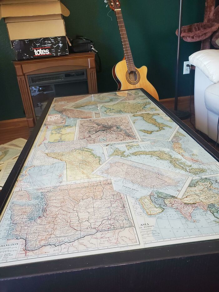
Used Some Old Damaged Atlas Pages To Decorate Under The Glass Of My Coffee Table

Used Some Old Damaged Atlas Pages To Decorate Under The Glass Of My Coffee Table

Noesiph Report

Add photo comments
POST
nfrlprdpr avatar
Mazer
Community Member
2 years ago DotsCreated by potrace 1.15, written by Peter Selinger 2001-2017

Looks wonderful. Hint don’t invite a map lover over for a conversation if you want them to pay attention to you

View More Replies...
View more commentsArrow down menu
#69

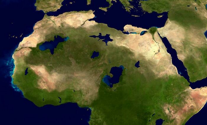
The Green Sahara (11000-5000 Years Ago)

The Green Sahara (11000-5000 Years Ago)

bigchicken9 Report

#70

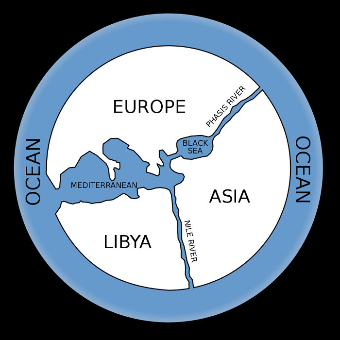
First Map Of The World By Anaximander

First Map Of The World By Anaximander

golifa Report

#72

Map Of Ottoman Empire In Early 16th Century. Handdrawn By Me

Map Of Ottoman Empire In Early 16th Century. Handdrawn By Me

ketolare Report

#73

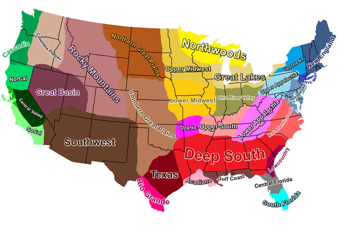
USA Cultural Regions Map

USA Cultural Regions Map

ladyegg Report

#74

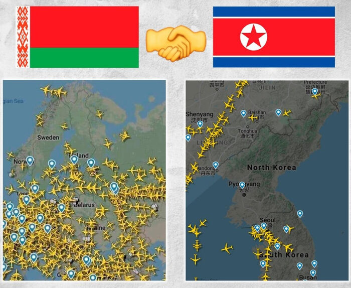
Comparison Of EU And East Asian Flight Paths After The Belarussian Air Space Incident

Comparison Of EU And East Asian Flight Paths After The Belarussian Air Space Incident

ManTuzas Report

Add photo comments
POST
ner_diz avatar
Serial pacifist
Community Member
2 years ago DotsCreated by potrace 1.15, written by Peter Selinger 2001-2017

The people in the two countries are pretty much like those people in M.Night Shyamalan's The Village - no planes fly above their heads, they are kept in the middle ages by their authorities who present everything from the outside as a scary threat where in reality they are the true boogeyman.

View more commentsArrow down menu
#75

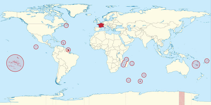
The French Republic — All Of It

The French Republic — All Of It

MaMamanMaDitQueJPeut Report

#76

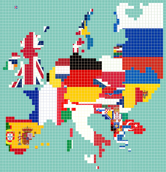
I Just Finished This Population Map Of Europe Where Each Pixel Means ~500,000 People

I Just Finished This Population Map Of Europe Where Each Pixel Means ~500,000 People

Morwon Report

See Also on Bored Panda
#77

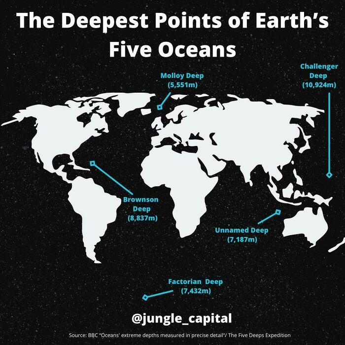
The Deepest Points Of Earth’s Five Oceans

The Deepest Points Of Earth’s Five Oceans

jungle_capital Report

Add photo comments
POST
nfrlprdpr avatar
Mazer
Community Member
2 years ago (edited) DotsCreated by potrace 1.15, written by Peter Selinger 2001-2017

The bummer is they found garbage in some of those deep deep placed

View more commentsArrow down menu
#78

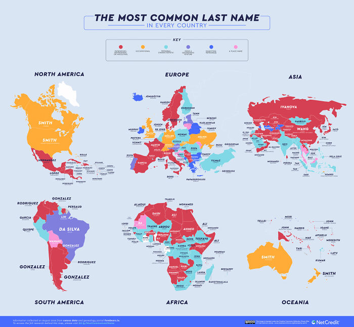
Most Common Last Name Per Country

Most Common Last Name Per Country

KreeJaffaKree Report

Add photo comments
POST
saihoekstra avatar
Sanne H.
Community Member
2 years ago DotsCreated by potrace 1.15, written by Peter Selinger 2001-2017

Is there a link to the original? So that I can read the names better?

View More Replies...
View more commentsArrow down menu
#79

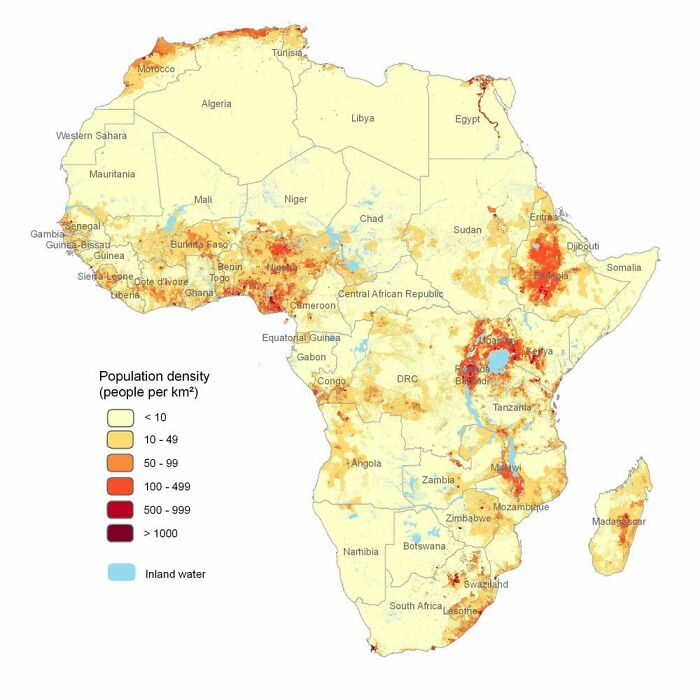
African Population Density

African Population Density

madrid987 Report

Add photo comments
POST
yvette_m_desmarais avatar
Yvette Desmarais
Community Member
2 years ago DotsCreated by potrace 1.15, written by Peter Selinger 2001-2017

Interesting how this correlates to the geographic map in another entry.

View more commentsArrow down menu
#80

A Raindrop Falling In Erie Co. Pa Will Travel 2,147 Miles To The Gulf Of Mexico Rather Than 15 Miles To Lake Erie

A Raindrop Falling In Erie Co. Pa Will Travel 2,147 Miles To The Gulf Of Mexico Rather Than 15 Miles To Lake Erie

LexFloruss Report

#81

Now You Can Figure Out How To Get Home If You're A Bit Farther Away Than Normal

Now You Can Figure Out How To Get Home If You're A Bit Farther Away Than Normal

NISCBTFM Report

Add photo comments
POST
#82

In The Process Of 3D Printing Manhattan, NY

In The Process Of 3D Printing Manhattan, NY

3Dcityframes Report

#83

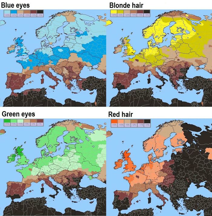
Blue/Green Eyes And Blond/Red Hair Across Europe

Blue/Green Eyes And Blond/Red Hair Across Europe

Stellarsleeper Report

Add photo comments
POST
christian-crisetig avatar
ADHORTATOR
Community Member
2 years ago (edited) DotsCreated by potrace 1.15, written by Peter Selinger 2001-2017

My father, my son and myself have green/grey eyes, the family is coming from the little spot in northern Italy :-)

View More Replies...
View more commentsArrow down menu
#84

Distribution Of The World's Primates

Distribution Of The World's Primates

Retard-Cheekz Report

#85

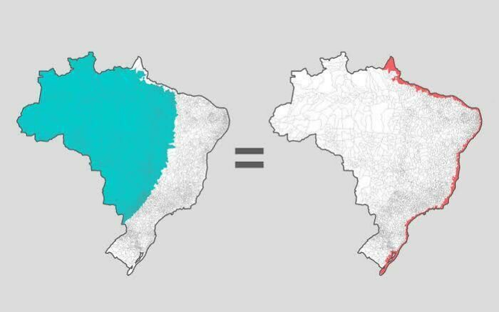
The Same Amount Of People In Brazil Live In The Highlighted Areas

The Same Amount Of People In Brazil Live In The Highlighted Areas

artistesatisfyaf Report

See Also on Bored Panda
#87

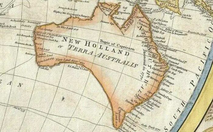
The Map Of Australia From 1794

The Map Of Australia From 1794

hydrolik43 Report

#88

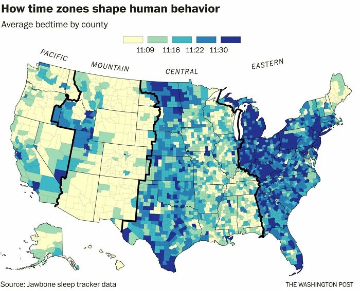
The Average Bedtime By County In The Us

The Average Bedtime By County In The Us

constantlyhere100 Report

Add photo comments
POST
alchristensen avatar
Al Christensen
Community Member
2 years ago DotsCreated by potrace 1.15, written by Peter Selinger 2001-2017

Western sides of time zones go to bed later because of the actual time of sunset.

View More Replies...
View more commentsArrow down menu
#89

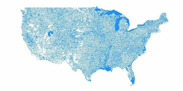
The United States As Only Bodies Of Water

The United States As Only Bodies Of Water

World-Tight Report

#90

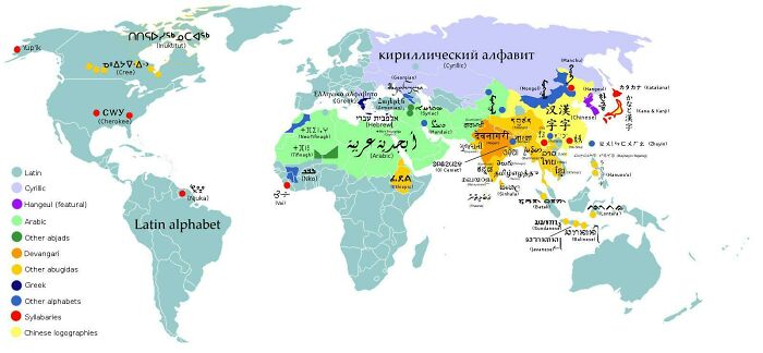
World Writing Systems

World Writing Systems

__PrathamYadav__ Report

Add photo comments
POST
pille-parn avatar
Pille P
Community Member
2 years ago DotsCreated by potrace 1.15, written by Peter Selinger 2001-2017

In India there are so many languages and a lot of these have their own scripts. More than pictured here.

#91

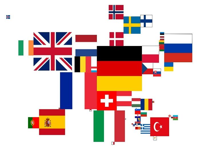
Map Of Europe If The Size Of The Countries Were To Be Their Gdp

Map Of Europe If The Size Of The Countries Were To Be Their Gdp

french_bobotte Report

Add photo comments
POST
pascaloudot avatar
Pascal Oudot
Community Member
2 years ago DotsCreated by potrace 1.15, written by Peter Selinger 2001-2017

I would like to have this map "per capita". It would be much more interesting... and world map too.

#92

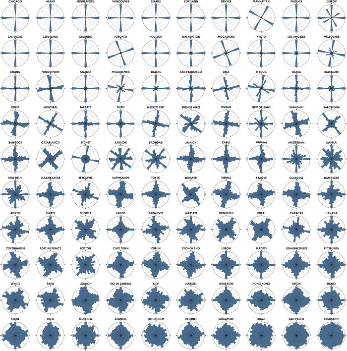
Polar Histograms Of Street Networks In 100 Major Cities Across All Continents, Ranked From Most Orderly To Most Disorderly (Each Histogram Bar’s Direction Represents The Compass Bearings Of The Streets, And Its Length Represents The Relative Frequency Of Streets With Those Bearings)

Polar Histograms Of Street Networks In 100 Major Cities Across All Continents, Ranked From Most Orderly To Most Disorderly (Each Histogram Bar’s Direction Represents The Compass Bearings Of The Streets, And Its Length Represents The Relative Frequency Of Streets With Those Bearings)

benjaneson Report

Add photo comments
POST
maylin_martinsen avatar
May
Community Member
2 years ago DotsCreated by potrace 1.15, written by Peter Selinger 2001-2017

Old cities that grew organically over a thousand years or so tend to be less ordered than newer, planned cities - hardly surprising.

View more commentsArrow down menu
#94

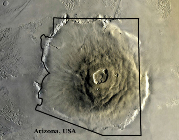
Olympus Mons Volcano On Mars Compared To The State Of Arizona:

Olympus Mons Volcano On Mars Compared To The State Of Arizona:

AryamanShetty Report

#95

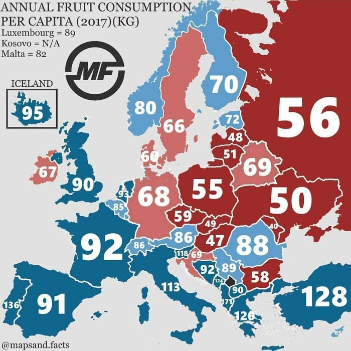
Annual Fruit Consumption Per Capita (2017, Kg)

Annual Fruit Consumption Per Capita (2017, Kg)

emir0723 Report

Add photo comments
POST
maylin_martinsen avatar
May
Community Member
2 years ago DotsCreated by potrace 1.15, written by Peter Selinger 2001-2017

I wonder if it's how much fruit is bought they're counting? Some people grow a lot of their fruit themselves, and I don't know hoe you'd count that.

View more commentsArrow down menu
#96

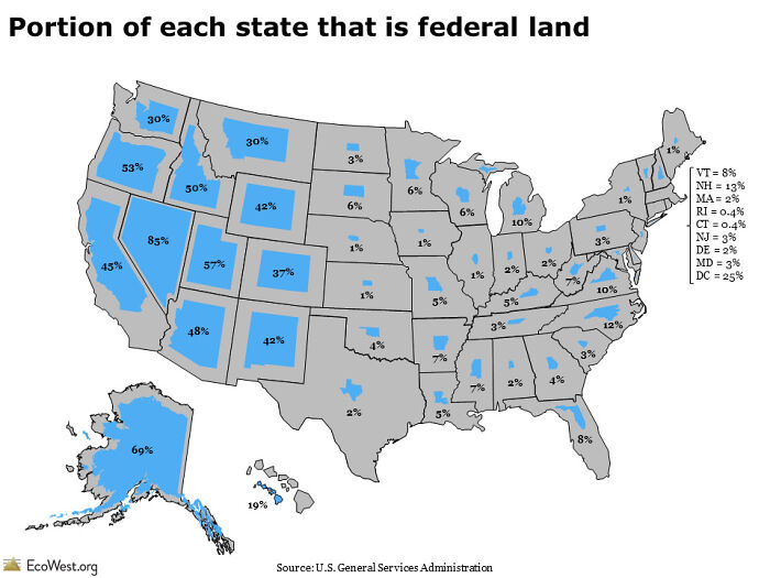
Portion Of Each State That Is Federal Land

Portion Of Each State That Is Federal Land

rimaildr Report

Add photo comments
POST
faithhh02 avatar
Faith Hurst
Community Member
2 years ago DotsCreated by potrace 1.15, written by Peter Selinger 2001-2017

This can be misleading. I live in a national forest, so technically I live on federal land.

View More Replies...
View more commentsArrow down menu
See Also on Bored Panda
#97

Tourist Map Of Death Valley (1929)

Tourist Map Of Death Valley (1929)

Petrarch1603 Report

Add photo comments
POST
nfrlprdpr avatar
Mazer
Community Member
2 years ago (edited) DotsCreated by potrace 1.15, written by Peter Selinger 2001-2017

I absolutely love maps like this, I try to pick them up whenever I can!! 1920’s!!!

View more commentsArrow down menu
#98

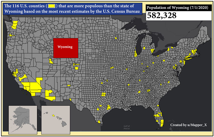
How Many U.S. Counties Have A Population Greater Than The State Of Wyoming?

How Many U.S. Counties Have A Population Greater Than The State Of Wyoming?

Mapper_X Report

#99

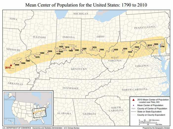
The Average Centre Of The U.S. Population Has Been Gradually Moving Westward Since 1790 And South Every Year Since The Introduction Of Air Conditioning In The 1920s

The Average Centre Of The U.S. Population Has Been Gradually Moving Westward Since 1790 And South Every Year Since The Introduction Of Air Conditioning In The 1920s

constantlyhere100 Report

Add photo comments
POST
nfrlprdpr avatar
Mazer
Community Member
2 years ago DotsCreated by potrace 1.15, written by Peter Selinger 2001-2017

And the migration size of the hummingbird has gotten a lot bigger because of the number of flowering plants and trees we have planted.

#100

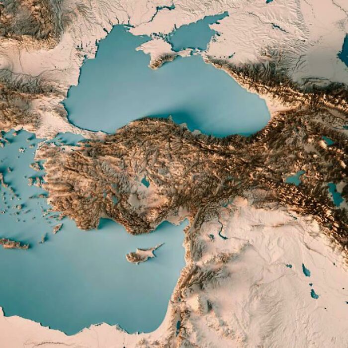
The Topography Of Turkey

The Topography Of Turkey

sreaht Report

Add photo comments
POST
schoolfreak32 avatar
David Butler
Community Member
2 years ago DotsCreated by potrace 1.15, written by Peter Selinger 2001-2017

See those three little flat bits on the northern coast in the middle? The easternmost corner of the boxy one on the right was the location of historical Themiscyra on the Thermodon River, the (alleged) capital city of the legendary Amazons.

#101

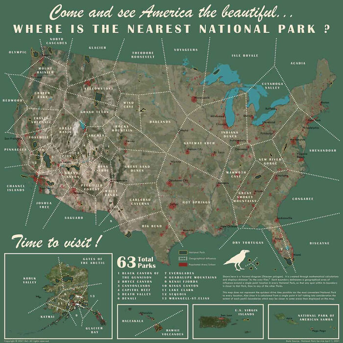
Where Is The Nearest National Park?

Where Is The Nearest National Park?

foxygrandpa203 Report

Add photo comments
POST
carriedehaven avatar
Carrie DeHaven
Community Member
2 years ago DotsCreated by potrace 1.15, written by Peter Selinger 2001-2017

Natural national parks. There are no historical national parks on here. Interesting, though, I didn't know Shenandoah was the closest natural national park for me.

View more commentsArrow down menu
#102

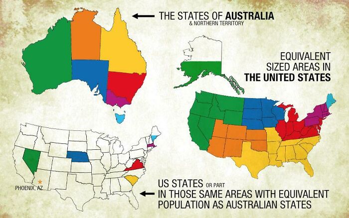
A Comparison Of Australian States And The United States By Area And Population

A Comparison Of Australian States And The United States By Area And Population

zhunu Report

#103

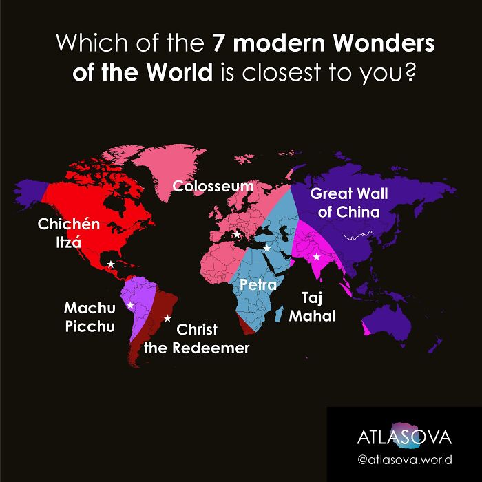
To Which One Of The 7 Modern World Wonders Are You Closest?

To Which One Of The 7 Modern World Wonders Are You Closest?

atlasova Report

#104

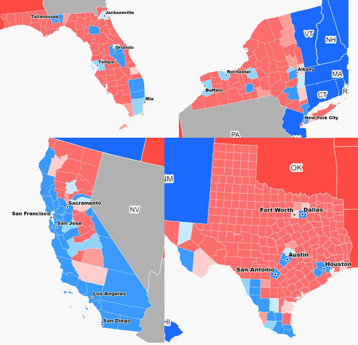
I Think Us Election Is Not About Republicans vs. Democrats But Urban vs. Rural

I Think Us Election Is Not About Republicans vs. Democrats But Urban vs. Rural

Europehunter Report

Add photo comments
POST
nfrlprdpr avatar
Mazer
Community Member
2 years ago DotsCreated by potrace 1.15, written by Peter Selinger 2001-2017

This is a bit misleading. I know for sure there are pockets of red in amongst those blues

View More Replies...
View more commentsArrow down menu
#105

Countries Larger Over Longitude Or Latitude

Countries Larger Over Longitude Or Latitude

dash_hhh Report

Add photo comments
POST
anne_juergens avatar
I’m A Black Cat
Community Member
2 years ago DotsCreated by potrace 1.15, written by Peter Selinger 2001-2017

The arrows for longitude and latitude are vice versa, also Greenland is not a separate country

View More Replies...
View more commentsArrow down menu
#106

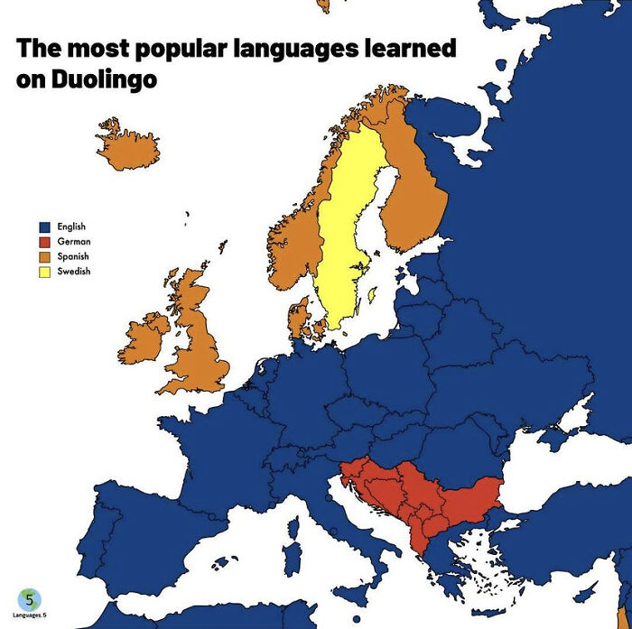
The Most Popular Languages Learned On Duolingo Per Country.

The Most Popular Languages Learned On Duolingo Per Country.

purin88 Report

Add photo comments
POST
ekaterinas avatar
Ekaterina S
Community Member
2 years ago DotsCreated by potrace 1.15, written by Peter Selinger 2001-2017

Well Kudos to Sweden, their school system is so good, they don’t need Duolingo! Also their immigrants really want to integrate themselves!

View More Replies...
View more commentsArrow down menu
See Also on Bored Panda
#107

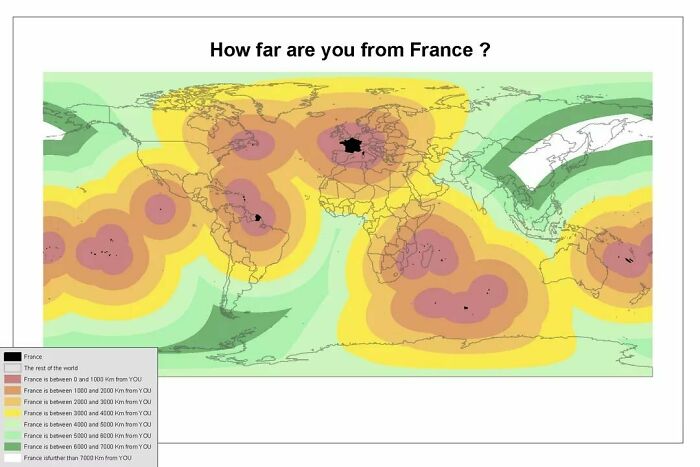
How Far Are You From France ?

How Far Are You From France ?

AllHailMadame Report

#108

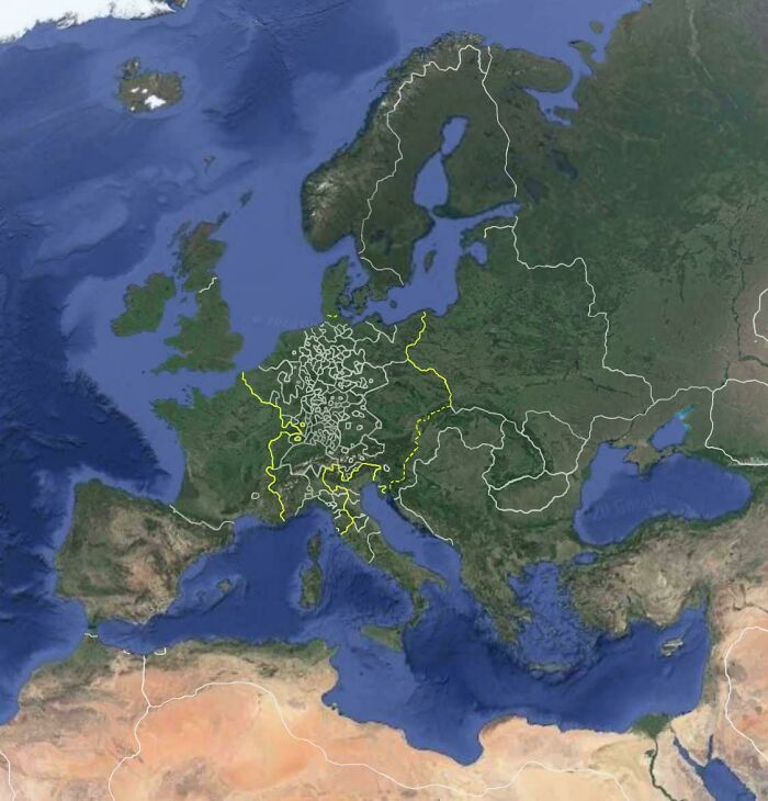
Google Earth In 1600

Google Earth In 1600

mattygilf Report

#109

USA Map In Russian. Enjoy Your Cyrillic

USA Map In Russian. Enjoy Your Cyrillic

angobando Report

#110

Antarctica Without Ice Fantasy Map (Made With Inkarnate)

Antarctica Without Ice Fantasy Map (Made With Inkarnate)

ChrisTheWhitty Report

#111

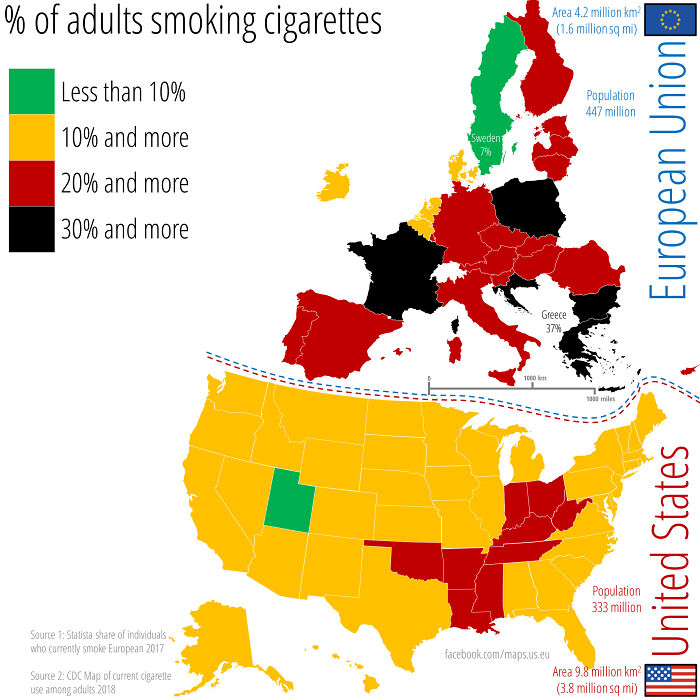
Percent Of Adults Smoking Cigarettes Across The Us And The Eu. Data For 2017/2018

Percent Of Adults Smoking Cigarettes Across The Us And The Eu. Data For 2017/2018

maps_us_eu Report

Add photo comments
POST
costa2706 avatar
Kari Panda
Community Member
2 years ago DotsCreated by potrace 1.15, written by Peter Selinger 2001-2017

I think this number will decrease in various countries over the next years. So many youths today are conscious of what‘s good for them and the environment.

View more commentsArrow down menu
#112

The World's Population Concentrated

The World's Population Concentrated

atlasmapper Report

Add photo comments
POST
#113

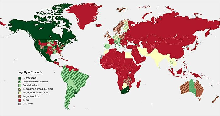
Legality Of Cannabis Around The World (July 1, 2021)

Legality Of Cannabis Around The World (July 1, 2021)

tennytits Report

#114

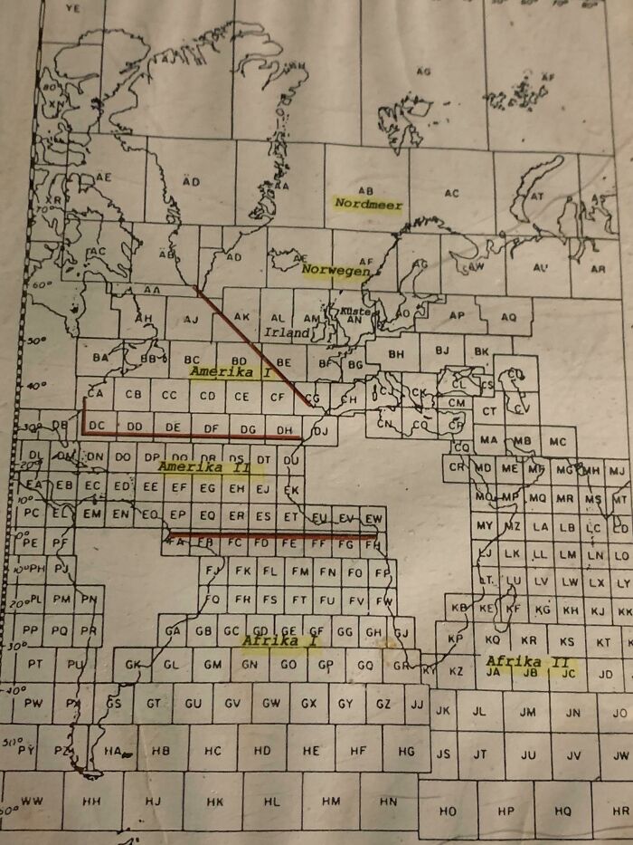
This German Submarine Map With Squares That Are All The Same Size

This German Submarine Map With Squares That Are All The Same Size

Ostseekabeljau Report

Add photo comments
POST
#115

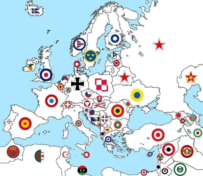
Symbols Of Aviation - Europe And Nearby (Source: Fb Page Of 303 Jag Squad)

Symbols Of Aviation - Europe And Nearby (Source: Fb Page Of 303 Jag Squad)

ieatbeet Report

#116

Got Bored In Class

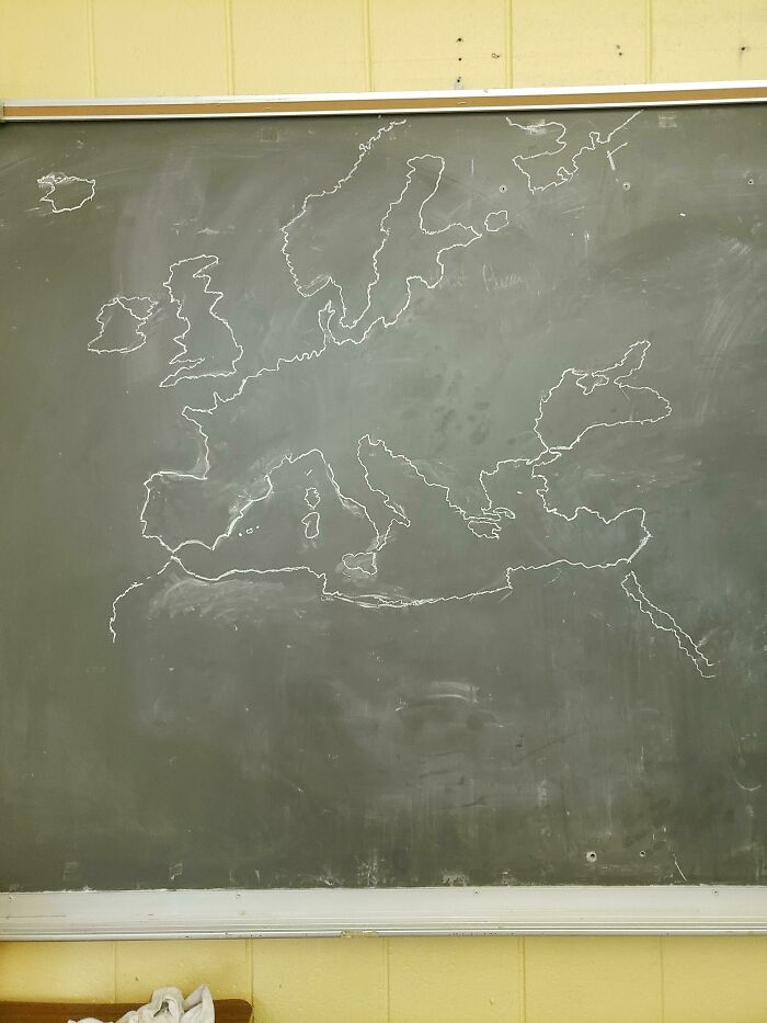
Got Bored In Class

RegnaGamer Report

Add photo comments
POST
otktuo avatar
Vuun
Community Member
2 years ago DotsCreated by potrace 1.15, written by Peter Selinger 2001-2017

I wonder if this was done from memory. Good effort if it was.

View more commentsArrow down menu
See Also on Bored Panda
#118

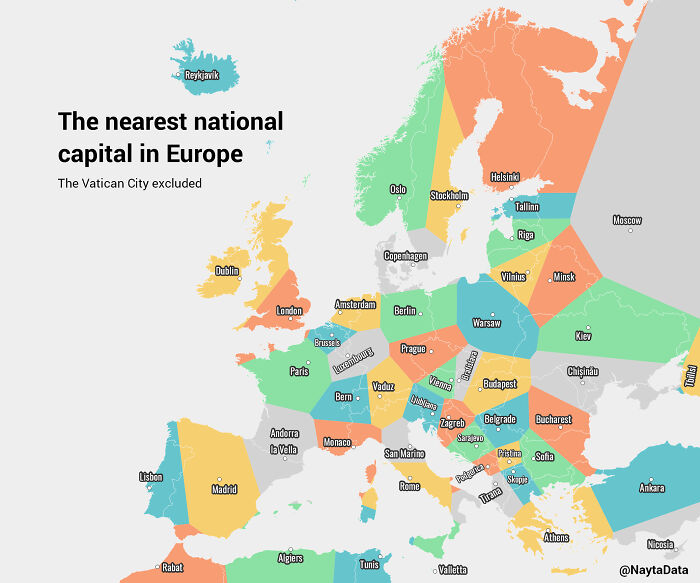
The Nearest National Capital In Europe

The Nearest National Capital In Europe

Rubenkubus Report

#120

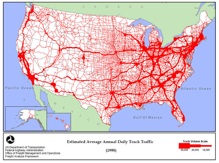
The Estimated Amount Of Daily Truck Drivers In The U.S. (1998)

The Estimated Amount Of Daily Truck Drivers In The U.S. (1998)

CheeseRP Report

Add photo comments
POST
#121

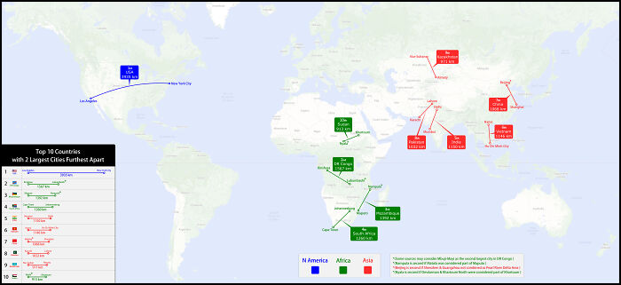
Countries With 2 Largest Cities Furthest Apart

Countries With 2 Largest Cities Furthest Apart

BerryBlue_BlueBerry Report

Add photo comments
POST
#122

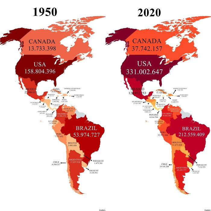
Population Of The Americas In 1950 vs. 2020

Population Of The Americas In 1950 vs. 2020

constantlyhere100 Report

Add photo comments
POST
#123

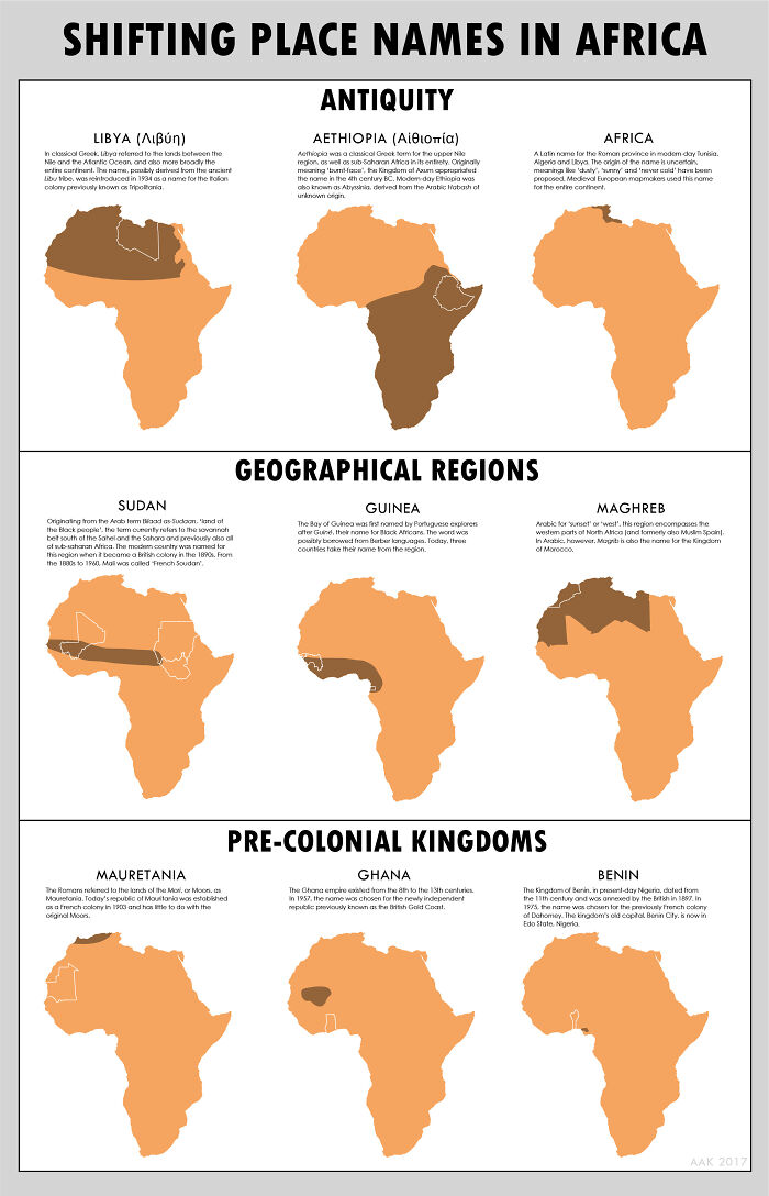
All Of Those Wandering African Place Names

All Of Those Wandering African Place Names

MBH1800 Report

Add photo comments
POST
#124

Olympus Mons Compared With France

Olympus Mons Compared With France

talgalus Report

Add photo comments
POST
anne-colomb1986 avatar
cassiushumanmother
Community Member
2 years ago DotsCreated by potrace 1.15, written by Peter Selinger 2001-2017

We are the real Chosen People! (not related with the map of Israel/Palestine conflict)

#126

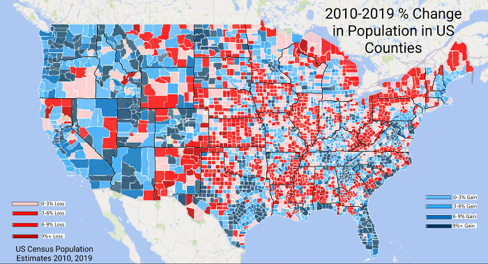
Where Americans Are Moving To (And Where They Are Leaving)

Where Americans Are Moving To (And Where They Are Leaving)

abeookes726 Report

Add photo comments
POST
See Also on Bored Panda
#127

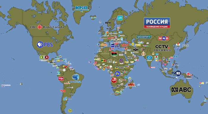
Public Broadcasters Of The World

Public Broadcasters Of The World

Ok-Codd Report

#128

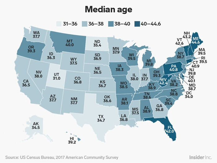
Median Age Of Us States

Median Age Of Us States

ScarAdvanced9562 Report

Add photo comments
POST
fracarr avatar
François Carré
Community Member
2 years ago DotsCreated by potrace 1.15, written by Peter Selinger 2001-2017

I read "742" for Florida and thought this might be a bit exaggerated.
#129

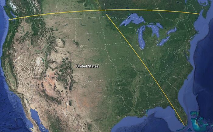
If You Draw "Straight" Lines Between The Northern And Southern Most Points In The Contiguous Us Along With The Eastern And Western Most Points The Two Lines Never Intersect

If You Draw "Straight" Lines Between The Northern And Southern Most Points In The Contiguous Us Along With The Eastern And Western Most Points The Two Lines Never Intersect

DarkerThanAzure Report

#130

Average Colors Of Western Europe As Seen From Space During 2018 (Map By Johannes Kroeger, Link In The Comments)
Average Colors Of Western Europe As Seen From Space During 2018 (Map By Johannes Kroeger, Link In The Comments)

hd189 Report