Admit it, once Google Earth was rolled out, you absolutely took a disproportionate amount of time checking out all the localities and areas on it to see if you can find something nostalgic, cool, or flat-out bizarre. And then Google Street View appeared and it was a game changer. Needless to say, you like maps. We’re all nerds like that.
And, well, there’s more to maps than just that. Check out these interesting takes on the US as seen from a top-down perspective, but instead of seeing vast landscapes and the occasional architectural screw-up, you see fun facts and information that might just make you smarter. I mean, it will if it’s not something you already know.
Scroll on.
This post may include affiliate links.
Topography Of USA


Tree Cover Map Of The US

Hold on, so the USA has a large Nullarbor (ie treeless) plain in the middle? Not just Australia?
States With A Smaller Population Than Los Angeles County

It goes without saying that the United States is a pretty big country. And, as such, there's ample opportunity to spot differences and variation on a slew of variables across the entire map.
Like, you probably never really needed to know how thick light pollution is across the US, but, hey, now you know that it’s the eastern part that’s very intense, and the western part is more or less not as polluted.
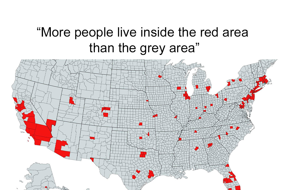
More People Live Inside The Red Area Than The Grey Area

Proof the electoral college is bogus. People vote, not land area.
Abandoned And Out-Of-Service Railroad Lines

Map Showing The Loudest And Quietest Areas In The US

And there is definitely a small contingent of people who benefit from this information—researchers, people who want to move states—it’s also there to make you look cool at parties with all that trivia you now know
All jokes aside, it’s useful to know where you’re going to live: what’s the crime rate there, how natural is the landscape, how populated it is—all of these factors are nice to know since you are deciding on moving there permanently.
Countries With Bases In The USA

If US Land Were Divided Like Us Wealth

Most Oddly Named Town In Each US State

But if that example is too specific, then maybe consider this: if you own a car, it’s likely that you use navigation on the regular. Apps like Google Maps and Waze have made it possible for people to have a bit more comfort in the car as at least you know where you’re going and why it’s taking you an extra 14 minutes to get there (darned traffic jams).
United States Population Lines

US States Scaled Proportionally To Population Density

Light Pollution In The United States

But seeing that arrow in your navigation is one thing. There’s an entire surrounding everywhere you go—knowing what’s around us brings us comfort and safety. And you never know when a beautiful lake will be sitting right next to where you keep passing by, but never look beyond that patch of trees that disguise it, making you think it’s just more forest there. Maybe taking a bicycle might help fix that problem. But check your map first!
The Most Efficient Route Between Every Springfield In The United States

US States By Violent Crime Rate

Average Color Of US State Based On Satellite Imaging

Another argument for the importance of maps is the idea of seeing where you’re going, where you are, and where you’ve been. It doesn’t really have to be a literal geographical map at this point, but a literal one might work too—just think of Google Maps Timeline.
If you’re unaware, Google Maps Timeline is a monthly service by Google that sends you recaps of where you’ve been over the past month, showing how many countries, cities and places you’ve visited in retrospect.
US Racial/Ethnic Diversity Map

I'm happy about Texas, but the number of people in Texas not happy about Texas makes me sad.
Most Spoken Languages In The US Beside English/Spanish

Most Popular Dog By US State

Outside their practicality, maps also ground us in reality. That can be either a good or bad thing depending on a number of factors, but there’s the idea that maps remind us we all live on the same planet. Sure, there's a great divide among nations and countries in terms of social, economic and climate factors. But we’re all in this together—we’re all citizens of this world. And that’s what folks ought to focus on.
Usage Of 'Dang' In The United States

Map Of The United States' 8 Million Miles Of Roads, Streets And Highways

And I have driven 2 million miles of them. The only states I have not driven every inch of Interstate in are Montana and North Dakota.
Some might argue that maps help us stay curious. Just like a change of scenery can help us gain some perspective and learn something about ourselves and others, i.e. travel, the idea of looking at a map and plotting your next adventure might just inspire an extra bit of curiosity and make you think “hey, I’ve never heard of this place.”
US Obesity Map

How America Utilizes Its Land

US Territories

No need to be an Empire of Conquered Land when you can just be the Empire of Global Capitalism. Would be nice if we actually were the "Empire" of Democracy, but unfortunately we don't live in that timeline...
The Most Dangerous Cities In The US

If we removed the 5 highest murder cities in the US (which only have 3% of the US population) the us moves to one of the lowest homicide rates in the world. Eliminate the top 10 with just 5% of the US population, we rank around Norway per-capita ranking. Most of our violent crimes and murder are a few area with just a tiny part of the US population. What the data shows is rather than sweeping large scale legislation (which for decades has not worked), we need focused surgical policies on those hot zones
There are only 6 cities on that map that I don't go to on a regular basis. All the others I visit, usually once a month, I have never had a problem. In 20 years of driving around the US, I've never carried a gun or even needed one. But I hate Cleveland, too many serial kiIIers.
Hey now. I moved to Akron five years ago, you should be good.
Load More Replies...I wonder why Minneapolis is so dangerous? Definitely not because we let a bunch of people riot and burn down minority buisneses and a police precinct? It also has nothing do with Liberal Judges letting out convicted murderers out of jail and then trying to ban civillians from owning guns to defend themselves. /s
"We'll try to stay serene and calm, when Alabama gets the bomb"--Tom Leher
Yeah, well, I'm about five miles south of San Bernardino, so... yeah, it belongs on the list.
Load More Replies...I am in a pretty safe area. And it extends in all directions for hundreds of miles. But never get complacent and always be aware.
I've lived in Kalamazoo and Milwaukee. I took police taught women's down and dirty self defense in both cities.
I'm surprised Wichita Kansas didn't make the list.. must be old stats
I live in one of these cities. If the criminals don't shoot you, the cops will.
Pueblo, CO Is dangerous in part because of poverty, which in turn drives the opioid crisis there.
Was surprised to see that the two towns in my state are next door.
5 cities in Central Arkansas, all within 20 minutes of each other are on the list...I had no idea. We make fun of pine bluff around here but but I guess we aren't any better in little rock...edit: 4 cities are that close together..Paragould (tiny farming town) is a couple of hours away and I can't believe it's on the map. There is nothing there!
Im seeing a LOT of those aggregator sites that real estate listings use ahowing crazy crime rates, but not much in the way of actual news items. Grains of salt should be taken, perhaps.
Load More Replies...Have you been to Rockford? It’s bad. Crime there is WAY worse than Chicago, and there is far more violent crime. Chicago isn’t nearly as bad as Fox News leads you to believe. It’s not even in the top 10 most violent cities.
Load More Replies...Man, the way Republicans go-on about crime in Chicago, and it doesn’t even make the list. Meanwhile, south of the Mason-Dixon Line… I’d like to make this about politics but is mostly about poverty and inequality.


Which Coffee Shops Has The Most Locations Per State

Lastly, maps are an integral part of how we function as human beings. There’s a geographical map (of which there are many types), a building evacuation map, a website map, a mind map, process maps, network maps, story maps, treasure maps, and, to some degree, flowcharts. Needless to say, we need all of these. Especially treasure maps.
Highway Signs For Each US State And Territory

Red And Orange Areas Have Equal Populations

Origin Of US State Names


Air Traffic Control Zones In The USA

Average Money Spent On Weddings In US States

So, what are your thoughts on any of this? Have some maps that you were blown away by? Share them, or anything map related, really, in the comment section below!
And if you need more maps, we’ve got tons. No, that’s not an overstatement. Yep, it keeps on going. OK, that’s enough.
Here’s A US Map Showing Where Horror Movies Took Place (By Andrew Brick)
")
Purchased Territories Of The USA

US State Mottos

Regions Of The U.S. That Don't Officially Celebrate Christopher Columbus Day

How does one "celebrate" that disgusting individual? Go to a neighbour's house, steal all their stuff and leave a pox-ridden blanket there, perhaps?
Most Expensive Toll Roads In The US

US States By Wikipedia Article Length

The Most Popular Unisex Baby Names By US State (2020)
")
The Safest Cities In The US

So apparently I live in the safest town, we definitely didn’t just have a triple homicide, domestic abuse that I’m pretty sure ended in death, someone stealing a bike and returning it with a bloody shoe, and bomb threats at school, were real safe


US Pronunciation Of Pecan

Most Popular US Female Baby Names 2022

Illegality Of Women Going Topless In Public In The US

So, you are telling me in all the states in white, it is not illegal? Yeah well, I think this map is a little skewed.
US Housing Shortage

US Counties With GDP Over $100b

The cities. Boston, MA - Philadelphia, PA - Atlanta, GA - Miami, FL - Houston, TX- San Antonio, TX - Dallas-Fort Worth, TX - Phoenix, AZ - San Diego, Los Angeles, San Francisco, CA - Minneapolis, MN - Chicago, IL - Detroit, MI.
Seat Belt Laws In The US

After living in CA for most of my life, I feel super weird to be in a car without a seatbelt on.
US States By Human Development Index


it is interesting how many maps have a distinct division just west of the Mississippi River
Bored Pandas done multiple articles like this covering the whole world, just search “Maps” and im sure it will pull them up :)
Load More Replies...A quick not exhaustive search turned up: two weeks to seven years.
Load More Replies...Use the top of page search field: "maps europe" or just "maps"
Load More Replies...I love stuff like this because I am very visual, I like charts too.
Shouldn't the title of this post be "Random Stuff Which Gives an Opportunity for All the Doomer Trolls to Dump on the United States "?
