Get Premium
Dark mode theme is available exclusively for premium users. Learn more about the benefits of subscribing.
No fees, cancel anytime.

 Dark Mode Ad-Free Browsing Unlimited Content
 Ad-Free Browsing Unlimited Content Dark Mode
Join 1.2 million Panda readers who get the best art, memes, and fun stories every week!
Are you a fan of cartography but curious to see the world through a different lens? Have you ever wondered how many blue whales would fit into the Vatican? Or what would the ancient continent of Pangea would look like with modern political borders? Or maybe you just would like to see how Manhattan looked while it was still called New Amsterdam?
If you've said "yes" to at least one of these, you're in luck! Bored Panda has prepared a compilation of cool maps from the Vintage Maps page on X where you can learn history and interesting new facts through the medium of cartography. So, scroll through these maps and marvel at how cool our world is.
More info: X (Twitter)
This post may include affiliate links.
I grew up right in the centre, and I can tell you there's a very good reason why all the people live where they do.
I wonder what constellations they used. Right-hand corner looks like Orion, so they seem to have seen a similar picture in that group of stars.
I'm trying to work out exactly what one that is in SW Wales. Is that Moridunum perhaps? Modern name Caerfyrddin/Carmarthen. A LOT of historians do like to claim that Romans never went that far west in Wales, in spite of the clear evidence in Carmarthen itself. Random map on the internet possibly being more accurate than quite a number of Roman Britain historians.
This map was on the inside covers of my aunt's first edition copy. I adored that book.
Kashmir is such a beautiful place but it’s honestly a shame that the situation is such that it’s unsafe to visit
Something I love is how every culture has at some point had a mythological story about a great flood as it shows how our cultures have originated near rivers and experienced major. river flooding at some point
It always takes me a while to get my Bering(s) with this map. It's difficult to sea strait.
I often think about those people who migrated across Oceania. Those islands would’ve been very small and spread so far apart yet humans were able to somehow do it. I wonder how many of them didn’t make it, sailing across vast distances can be pretty hard especially with wooden rafts yet somehow just enough of us did
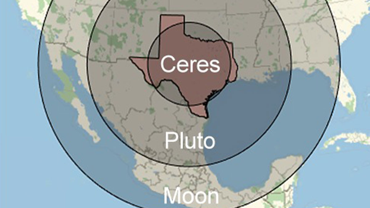
I will never shut up about how Pluto gets more attention than all the other dwarf planets just because it’s the only one you remember. The other dwarf planets are equally as interesting with interesting histories as well. Did you know that at one point Ceres was demoted from a planet to an asteroid and then to a dwarf planet? Did anyone complain back then about their favourite planet Ceres becoming an asteroid?
"New Amsterdam" marks a relatively short 40 years time window (AFAIK) - and in this map there is already an "old church yard". I find that curious 😄
The US has minted its last one cent coin as of 2025, so no more pennies.
I would like to see a similar map of he places mentioned in Highway Number One (Australia)
Someone better remind the orange Oompa-Loompa that Bad Bunny is actually an American.
This is true. On a larger scale I live between *LA* Dordogne and *LA* Garonne, but the little river running through our local area is *LE* Dropt (it is a right tributary to the Garonne). It becomes second nature after a while, which is rather strange.
The area to the north of Joseon and east of Northern Yuan was the Jianzhou Jurchen Confederation. About 50 years after this map, the Ming tried to destabilise the Confederation, taking the grandson of one of the Jurchen chieftains (Giocangga) hostage and allying with another chieftain (Nikan Wailan). That hostage grandson was a boy named Nurhaci, who would go on to become the chieftain of the Jianzhou Confederacies, united the Jurchen under the name of "Manju" (anglicised: Manchu, believed to be an older name for the Jurchen) and under his banner of the Later Jin (renamed Daicing Gurun/Great Qing by his son and successor Hong Taiji, the Qing Dynasty you might know it as). They would become part of the fall of the Ming, and I find the lack of presence of the Jianzhou Jurchen Confederation annoying for how important they are to history, especially since the Four Oirat/Oirat Confederation is on here (so it is including important Asian continent Confederations).
India and I think to an extent China have huge variations in climate across the country. What I know about India is that while it may be snowing in Kashmir, you could be boiling to death in South India while North-East India enjoys heavy rains
Trying to decide if I should move to Illinois/get permit for kangaroo OR move to Wisconsin and go wild owning a kangaroo without a permit.
Florida hates Florida? That would show some insight I didn't quite know they had.


 No fees, cancel anytime


")
")