ADVERTISEMENT
Article created by: Rugilė Žemaitytė

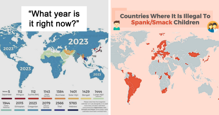
Who doesn't love a good map? I'd even say we'd get lost without one. They enrich our understanding of the world in a simple, visual way.

Maps teach us not only about the size and shapes of countries but also show many more interesting things, like earthquake locations and wealth distribution. The local status of gay marriage or car reliance. Pretty much everything we have data on!

So let's revisit this subreddit for a new dose of cartography — it hits just as strong as the previous ones.

#1

Lithuania Has Made A Map Of Magnets In Which Each Magnet Can Only Be Found In A Specific Area, To Boost Tourism, Specifically Local Tourism. (Credit To Demilked)

Colorful illustrated map refrigerator magnet showcasing a unique and surprising side to the world we live in.

StrawWordXbox Report

RELATED:
    #2

    Outline Of The World By Mapping All Lighthouses (Osm Data, Oc)

    World map with highlighted populated areas showing a surprising different side of global population distribution.

    bored_panda87 Report

    #3

    Countries Where It Is Illegal To Spank/Smack Children (700x700)

    World map highlighting countries where it is illegal to spank or smack children, showing surprising global differences.

    john_doe_89 Report

    #4

    What Year Is It Right Now?

    World map showing different calendar systems and current years in each country, highlighting surprising maps of the world.

    ledim35 Report

    ADVERTISEMENT
    #5

    A Population Density Map Of Illinois

    3D map of Illinois population density showing surprising data visualization with spikes indicating urban areas and population clusters.

    Pecners Report

    #6

    Mediterranean Sea Fits Inside Australia - Should Be A Much Better Image Than Last One

    Map of Australia showing surprising alternative sea names and geographic labels revealing a different side to the world.

    SteelDeliverance Report

    #7

    Someone Here Posted A Map Of Earthquakes Since 1900(Top One) Now Watch It 1by1 To The Map Of Actual Tectonic Plates(Bottom One)

    World map showing earthquake magnitudes from 1900-2017 and tectonic plate boundaries in yellow lines.

    Lntc26 Report

    #8

    1920 Australian Map Of Sheep

    Vintage map of Australia showing sheep and wheat distribution with surprising regional variations across the country.

    Evilaars Report

    ADVERTISEMENT
    ADVERTISEMENT
    #9

    Where Does The World's Population Of 8 Billion Live?

    World population distribution map showing countries by number of people, highlighting major population centers across continents.

    pratapvardhan Report

    #10

    Here Is A 1988 Map Of Berlin (Produced In The Ddr)

    Map highlighting Berlin and surrounding areas with detailed roads and locations, part of surprising maps showing a different world view

    BFNgaming Report

    #11

    Number Of Ukrainian Refugees Displaced In Europe In February 2023

    Map showing the number of Ukrainian refugees across Europe by country with color-coded density and exact figures.

    Relocationstation1 Report

    #12

    The World In 250 Million Years

    Map showing the world in 250 million years with continents colliding and mountains rising in a surprising perspective

    Tacama Report

    ADVERTISEMENT
    #13

    Estimated Migration Of Early Homo Sapiens Out Of Africa To The Rest Of The World, In Thousands Of Years Ago (Kya)

    Map illustrating ancient human migration patterns with arrows and timelines, showing surprising maps revealing different world perspectives.

    CaptainJZH Report

    #14

    Relief Map Of San Marino

    Illustrated map of San Marino showing its mountainous terrain and surrounding towns in a surprising world map style.

    Kl--------k Report

    #15

    All Shootings vs. Shootings With Officer Involved In Chicago (2014-2022)

    Side-by-side maps showing all shootings and officer-involved shootings in Chicago with fatal and nonfatal cases.

    flyingcatwithhorns Report

    #16

    Turkey, Bordering 7 Different Countries With 7 Different Alphabets

    Map showing alphabets of selected countries with Latin, Greek, Cyrillic, Arabic, Persian, Georgian, and Armenian scripts.

    Bladest0 Report

    ADVERTISEMENT
    #17

    The Largest Towns In 1050 In Europe, North Africa And West Asia (Population Over 40 Thousand)

    Map showing population of towns over 40 thousand in Europe and the Middle East in 1050 with key historical cities marked.

    Yellowapple1000 Report

    #18

    Public Transport Network Density

    Maps showing public transport network density across major European countries highlighting surprising regional coverage differences.

    YellowOnline Report

    #19

    The Best And The Worst For Lgbtq+ Travelers

    Color-coded world map showing the best and worst countries for LGBTQ+ travelers according to safety levels in 2021.

    EinHoer23 Report

    #20

    How Big Brazil Actually Is!

    Map showing Brazil's size compared to North America with major cities highlighted for surprising world perspective.

    AbhiExplains Report

    #21

    Places That "Don't Exist" According To Internet Memes (Many Based On The Original "Bielefeld Conspiracy")

    World map highlighting surprising places that do not exist, showing a different side to the world we live in.

    DanArv1316 Report

    #22

    The Size Of Australia vs. Other Countries

    Map of Australia divided into European countries’ shapes, showing a surprising view of the world with unique map perspectives.

    charmanduuur Report

    #23

    The U.S. Map Redrawn As 50 States With Equal Population

    Map of the United States redrawn into fifty states with equal population showing surprising geographical divisions.

    afreshsplat Report

    #24

    Russia’s New Border With Nato Now That Finland Is Finally In Nato!

    Map showing length of Russia's border with NATO and countries joining or applying to join NATO over time.

    AccurateSource2 Report

    #25

    Most Common Country Of Birth For Residents Of Foreign Origin, Excluding Mexico

    Map of the United States showing the most spoken foreign languages by state with flags representing each language and country.

    red_ivory Report

    #26

    Status Of Gay Marriage In Europe

    Map of Europe showing countries with marriage and civil union laws, highlighting surprising maps that reveal a different side of the world.

    Reasonable_Ninja5708 Report

    See Also on Bored Panda
    #27

    The First World Map By Anaximander Of Miletus (610bc-546bc), Greece Mathematician And Geographist. Original Map Was Not Saved!

    Simplified map showing Europe, Asia, Libya, and surrounding water bodies highlighting surprising map perspectives.

    Eli-Cohen Report

    #28

    Number Of Prisoners Per 100,000 People Across The World

    World map showing the number of prisoners per 100,000 inhabitants by country, highlighting surprising global incarceration rates.

    flyingcatwithhorns Report

    #29

    The 2022 Edition Of The Global Peace Index

    World map showing the state of global peace in 2022 with countries ranked by peace level and recent improvements or declines.

    6_zeros Report

    #30

    The Euler Diagram-Map Of The British Isles./-

    Venn diagram illustrating the geographical and political distinctions within the British Isles and United Kingdom regions.

    MildCreator Report

    #31

    Percentage Of Children Born Out Of A Registered Marriage

    Map of Europe showing the share of live births outside marriage by country with color-coded percentages.

    theworldmaps Report

    #32

    England, Right To Roam Map

    Map showing that only 8% of England is accessible for roaming, highlighting surprising maps of the world we live in.

    B2RW Report

    #33

    Robbery Rates In European Countries

    Map showing robbery rates per 100,000 inhabitants across Europe with color-coded regions and data labels.

    Useless_or_inept Report

    #34

    How Much Territory Russia And Ukraine Hold At One Year Of War

    Map showing Ukraine with regions invaded by Russia, highlighting territorial control and conflict zones in the world we live in.

    HarpuasGhost Report

    #35

    Percentage Of Europeans Whose Wealth Is Under $10,000

    Map showing the percentage of adults with wealth under 10,000 dollars across European countries in surprising world maps.

    Big-Way-9556 Report

    #36

    The Swedish Empire At It’s Height

    Map showing the Swedish Empire at its greatest extent in 1658, highlighting surprising maps of the world we live in.

    MeatyEmperor Report

    See Also on Bored Panda
    #37

    Legality Of Prostitution

    Map showing legality and maximum punishment for p**********n across European countries with color-coded regulations and fines.

    Dijjkstra Report

    #38

    Europeans Who Would Fight For Their Own Country

    Map showing percentage of Europeans willing to fight for their country, highlighting variations across different nations in Europe.

    CeceLovezz Report

    #39

    When Were Southamerica's Capitals Founded?

    Map showing the founding centuries of South America's capitals with color codes for surprising maps of the world.

    alikander99 Report