ADVERTISEMENT

Maps are awesome. And you can’t convince us otherwise. The obsessed, always-curious cartographer inside us gets excited every time they spot something new to ogle and analyze. However, not all maps are made equal. Some of them lean so heavily into comedy that we can’t help but spread the fun vibes.

The brainchild of Michael Howe, ‘Terrible Maps’ is a wonderfully witty social media project about nonsensical, semi-useless, and hilarious maps. They’re so ‘bad’ they’re good, and they help you look at the world from perspectives that you’ve never quite seen before. Scroll down to enjoy the latest batch below. We hope these maps make you as happy as they did us.

More info: Book | Facebook | Instagram | X | Linktree

#1

Nordic Map: Cat Edition

Three cats labeled as Norway, Sweden, and Finland cuddling closely in a funny map representation with humor.

Terrible Maps Report

RELATED:
    #2

    The Human Race Never Ceases To Amaze

    Map showing Google search volume for eyes hurt by region and total solar eclipse path across the US in April 2024, funny maps theme.

    Terrible Maps Report

    #3

    When You're In Charge Of Naming Scottish Lochs And It's 4:59pm

    Map of Loch Lochy and surrounding areas showing roads and water features in a funny and unusual geography map style.

    Terrible Maps Report

    Making a map look good isn’t enough. Just like when you’re designing anything else, you have to find a delicate balance between function on the one hand and form on the other.

    The former means that whatever you’re creating actually does what it’s supposed to. In the case of a map, this might mean giving a person clear instructions on the geographical locations, educating them on a specific issue, or making them laugh.

    ADVERTISEMENT
    #4

    A World Map Centred Around Antarctica

    Polar view world map showing continents upside down, a funny geography map perspective for unusual map collections.

    Terrible Maps Report

    #5

    How People React When You Try To Speak Their Language

    Map of Europe showing countries color-coded with humorous captions reflecting language and cultural reactions.

    Terrible Maps Report

    #6

    Which Is Your Favourite Mexican Country?

    Fox News segment mistakenly labeling multiple countries as Mexican in a funny and horrible map of Central and South America.

    Terrible Maps Report

    Raven Sheridan
    Community Member
    4 months ago Created by potrace 1.15, written by Peter Selinger 2001-2017

    Does that make the United States, North Mexico? 🤔

    View more comments

    Function aside, the form of what you’re designing matters a lot, too. Like it or not, human beings are drawn to beautiful things. When you make something aesthetic, it captivates people.

    Naturally, if you’ve spent a lot of time working on a map, making it the best it can possibly be, you want it to end up being seen by the biggest number of people possible. So, you need to spend some time refining the visuals to make it pleasant to look at.

    ADVERTISEMENT
    #7

    Ancient Grease Map

    Brown paper bag with water stains resembling a world map, a funny map you wouldn’t find in a geography book.

    Terrible Maps Report

    #8

    A Map Of Sunken Japanese Ships From World War II

    Map showing Japanese naval ships location with red markers, a horrible but funny map not found in typical geography books

    Terrible Maps Report

    ADVERTISEMENT
    #9

    Japanese Stereotypes Of Europe

    Funny map of Europe with humorous stereotypes and labels, showcasing a horrible but funny maps concept.

    Terrible Maps Report

    All that being said, if you veer too much in either direction, prioritizing form over function or function over form, you might end up pushing people away.

    For example, if your map looks absolutely divine, full of artistic flourishes, gorgeous fonts, and well-coordinated colors, but your audience gets lost among the details, you’ve failed as a cartographer.

    ADVERTISEMENT

    Often, less is more.

    You need to use the visuals to make it clear what the most important information on your map is.

    #10

    India As Seen By Indians

    Funny map of India with humorous labels showing bizarre regional stereotypes and cultural jokes in a geography-themed illustration.

    Terrible Maps Report

    Nea
    Community Member
    4 months ago Created by potrace 1.15, written by Peter Selinger 2001-2017

    Upvote for an Indian map on Bored panda map post.

    View more comments
    #11

    Well, That's One Way To Do It

    Property map with incorrectly labeled building numbers, illustrating a funny and confusing geography map mistake.

    Terrible Maps Report

    #12

    World Map Of Borders

    Unusual world map made with interconnected country flags illustrating a funny and horrible geography concept.

    Terrible Maps Report

    Chewie Baron
    Community Member
    Premium
    4 months ago Created by potrace 1.15, written by Peter Selinger 2001-2017

    I like how Japan looks like a randomly placed fried egg.

    View more comments

    On the other side of the scale, you have maps that are incredibly accurate and informative, but they lack that spark that would otherwise make them stand out from the crowd.

    ADVERTISEMENT

    So, they fulfill their function well, but their form falls short of good design principles. A bit of imagination and soulfulness can really make your map sing.

    People are very visual creatures. You need to know how to get their attention instantly as they’re scrolling through their social media feeds.

    #13

    Percentage Of People That Can Hold A Conversation In Icelandic

    Map of Europe showing percentage data with Iceland above 95%, part of a collection of horrible but funny maps.

    Terrible Maps Report

    Glix Drap
    Community Member
    4 months ago Created by potrace 1.15, written by Peter Selinger 2001-2017

    Err, what has happened to the British Isles?

    View more comments
    #14

    Nature Is Amazing. Here's An Image Of The Carina Nebula From The James Webb Space Telescope — It Matches The Eastern Coast Of Algeria

    Space nebula with star formations above a satellite image of a coastal region showing land and water geography maps.

    Terrible Maps Report

    Serial pacifist
    Community Member
    4 months ago Created by potrace 1.15, written by Peter Selinger 2001-2017

    Just leaving a comment for a lonely nebula with no comments ❤️

    View more comments
    #15

    How To Build A T-Rex

    Humorous world map showing continents reshaped as parts of a dinosaur, illustrating funny maps for geography humor.

    Terrible Maps Report

    People’s attention spans are short enough as they are right now. Based on recent research, the average person spends just 47 seconds using an electronic device before shifting their focus to something else.

    This used to be 2.5 minutes back in the early 2000s.

    So, the competition between digital creators for your attention on social media is even more intense.

    #16

    Countries That Have Eaten Their Prime Minister

    Map of Europe showing which countries have eaten their Prime Minister, highlighted in green, red, and yellow.

    Terrible Maps Report

    Phantom Phoenix
    Community Member
    4 months ago Created by potrace 1.15, written by Peter Selinger 2001-2017

    Were the No Data countries unable to answer because there was some doubt? "We ate bits of somebody. Could've been the PM, might not have been."

    View more comments
    #17

    "Coma" (Medical Term) In European Languages

    Europe map showing countries labeled with coma or sleep in a humorous style, highlighting Poland differently in red.

    Terrible Maps Report

    Luke Branwen
    Community Member
    4 months ago Created by potrace 1.15, written by Peter Selinger 2001-2017

    Polish is a fun language - the Polish verb "to look for, search for something" is almost identical to Czech "to f@ck." We're both having a lot of fun with that one.

    View more comments
    #18

    Top-Selling Musical Artists From Each English County

    Funny map of England with regions labeled by famous music artists, showcasing a humorous and creative geography twist.

    Terrible Maps Report

    wowbagger
    Community Member
    4 months ago Created by potrace 1.15, written by Peter Selinger 2001-2017

    England has given the world some great music!

    View more comments

    As per Geography Realm, something to keep in mind when making a map is that you should only picture the area that is relevant to the data.

    That sounds like common sense, but it’s fundamental.

    What's more, any data that you choose to include on the map itself should be relevant. “Cluttering the map with too much background data can lead to excess noise and dilute the actual message of the map.”

    #19

    Europe If Europe Had Colonised Europe

    Europe map with exaggerated and altered country shapes, showing a humorous and unconventional geography perspective.

    Terrible Maps Report

    Verena
    Community Member
    4 months ago (edited) Created by potrace 1.15, written by Peter Selinger 2001-2017

    For those who wonder: The lines were decided upon by following longitudes, latitudes, rivers and mountain tops - that one above would have been impossible to do for the surveying techniques of 500 years ago. PS: This is why the USA looks so boxy.

    View more comments
    #20

    If You Laid The Great Wall Of China Around Europe’s Coastline

    Map of Europe with exaggerated red border outlining countries, illustrating a funny and horrible geography map concept.

    Terrible Maps Report

    Michael Largey
    Community Member
    4 months ago (edited) Created by potrace 1.15, written by Peter Selinger 2001-2017

    Someone told a Brit that he could fir=t all of his country in Nebraska. He replied "Yes, but why would I want to?"

    View more comments
    #21

    The U.S. Map With Between 3 And 500 Edges

    Series of blue US maps showing distorted shapes with increasing numbers, illustrating funny maps for geography humor.

    Terrible Maps Report

    Forrest Hobbs
    Community Member
    4 months ago Created by potrace 1.15, written by Peter Selinger 2001-2017

    This one is genuinely fascinating. Brilliant.

    View more comments

    Meanwhile, you should put a lot of care into the symbology of your map. Some of the most important things that affect the readability and message of your map are:

    1. The color choices you make
    2. The widths of your lines
    3. The icons you use
    4. The labeling

    Of course, no proper map is complete without a legend. It allows your audience to decipher the symbology of the map. In a nutshell, the legend has to be legible and easy to understand.

    #22

    How Hard It Is To Understand Spanish Accents

    Map showing difficulty levels of Spanish language across Latin American countries with color-coded regions and a humor theme.

    Terrible Maps Report

    digitalin
    Community Member
    4 months ago Created by potrace 1.15, written by Peter Selinger 2001-2017

    I've been learning Spanish and a Dominican friend I hadn't seen in a while said I now had a Central American accent! Probably from practicing so much with my friend from El Salvador. It's a very big achievement for me to be able to speak enough to show any accent at all besides struggling American English.

    View more comments
    #23

    The Country Each European Nation Jokes About Most

    Map of Europe showing which countries Europeans joke about most with country flags overlaid humorously.

    Terrible Maps Report

    Piwakawaka
    Community Member
    4 months ago Created by potrace 1.15, written by Peter Selinger 2001-2017

    Actually ths must be old. Nowadays they would all have the US flag.

    View more comments
    #24

    Countries Where The National Anthem Mentions Blood

    World map highlighting countries in red with a focus on funny and unusual geography maps for visual humor and interest.

    Terrible Maps Report

    Verena
    Community Member
    4 months ago Created by potrace 1.15, written by Peter Selinger 2001-2017

    It can be harmless. The Dutch one "I am from German blood" = the ancestors of Willem I were German

    View more comments

    ‘Terrible Maps’ has become so popular that Howe even ended up publishing a book—‘Terrible Maps: The stupidly funny illustrated gift book perfect for geography lovers’—full of the most hilarious ones he’s crafted. According to the author, the book is a celebration of “pointless cartography in all its glory.”

    ADVERTISEMENT

    Bored Panda has reached out to Howe via email to learn more about the entire project, and we’ll update the article as soon as we hear back from him.

    #25

    2,066 Americans Were Asked To Locate Ukraine On A Map

    Worldwide map showing population density with humorous color patterns highlighting Europe and Asia regions.

    Terrible Maps Report

    Niki
    Community Member
    4 months ago Created by potrace 1.15, written by Peter Selinger 2001-2017

    *Screams in geography teacher*

    View more comments
    #26

    Europe If Sea Levels Went Up 100m

    Map of Europe with country borders outlined, part of a collection of horrible but funny maps for geography humor.

    Terrible Maps Report

    Schnitzel
    Community Member
    4 months ago Created by potrace 1.15, written by Peter Selinger 2001-2017

    I'm in Stockholm so I'm screwed :-/

    View more comments
    #27

    Countries Where It's Illegal To Pee In The Sea

    Map of Europe with Portugal highlighted in red, showcasing a funny and horrible map style not found in typical geography books.

    Terrible Maps Report

    The ‘Terrible Maps’ project has seen incredible success over the years. For example, on Facebook alone, the project’s account has garnered 1.2 million followers and 882k likes.

    Meanwhile, even more people follow its account on X (formerly Twitter): 1.7 million people from around the globe are fans of the page there. And on Instagram, a further 382k people follow ‘Terrible Maps.’

    #28

    San Diego Looks Like A Flooded Melbourne

    Side-by-side maps of Melbourne and San Diego highlighting funny differences in geography and layout.

    Terrible Maps Report

    Michael Largey
    Community Member
    4 months ago (edited) Created by potrace 1.15, written by Peter Selinger 2001-2017

    The best thing about San Diego County is that humidity is illegal there.

    View more comments
    #29

    European Places With More Sheep Than People

    Europe map with sheep icons humorously added in specific countries, illustrating a funny and horrible map concept.

    Terrible Maps Report

    Glix Drap
    Community Member
    4 months ago Created by potrace 1.15, written by Peter Selinger 2001-2017

    In Wales they are called recreational animals.

    View more comments
    #30

    Mapping Spanish Stereotypes

    Humorous map of Spain with funny and horrible regional stereotypes not found in geography books.

    Terrible Maps Report

    What are your thoughts about ‘Terrible Maps,’ dear Pandas? Which of the maps that we’ve showcased here today amused you the most? Which ones did you find surprisingly informative, despite the witty ideas behind them?

    On a scale of 1 to 10, how big of a cartography and geography fan would you say you are? We’d like to hear from you. Share your thoughts below!

    #31

    Prisoners Per 100,000 People

    Color-coded world map showing prison population per 100,000 people, highlighting unusual and funny geographic data visualization.

    Terrible Maps Report

    Billy Peters
    Community Member
    4 months ago Created by potrace 1.15, written by Peter Selinger 2001-2017

    Now this is a good one! China 100-150 lol. Oh yeah, and Australia!

    View more comments
    #32

    Countries Mentioned In The Bible vs. % Of Population Practising Christianity

    World maps showing regions in red and shades of blue depicting population percentages of Christians across different countries.

    Terrible Maps Report

    Michael Largey
    Community Member
    4 months ago Created by potrace 1.15, written by Peter Selinger 2001-2017

    Few countries are mentioned in "Pride and Prejudice", but it's still a great book.

    View more comments
    #33

    Map Showing The Hairiest Countries In The World

    World map showing frequency of male androgenic hair among indigenous populations with varying red shades for concentration levels.

    Terrible Maps Report

    Niki
    Community Member
    4 months ago Created by potrace 1.15, written by Peter Selinger 2001-2017

    Absolutely hair-raising, I tell you.

    View more comments
    #34

    Map Of Countries That Lost Both World Wars

    Map of Europe highlighting Germany, Hungary, and Bulgaria in red, part of funny maps collection for humorous geography insights.

    Terrible Maps Report

    Michael Largey
    Community Member
    4 months ago Created by potrace 1.15, written by Peter Selinger 2001-2017

    I would include Austria and give Italy an option.

    View more comments
    #35

    Dividing The World By Nearest Australian Capital City

    World map with distorted city names and red curved shipping routes, a funny and horrible geography map illustration.

    Terrible Maps Report

    Pandemonium
    Community Member
    4 months ago Created by potrace 1.15, written by Peter Selinger 2001-2017

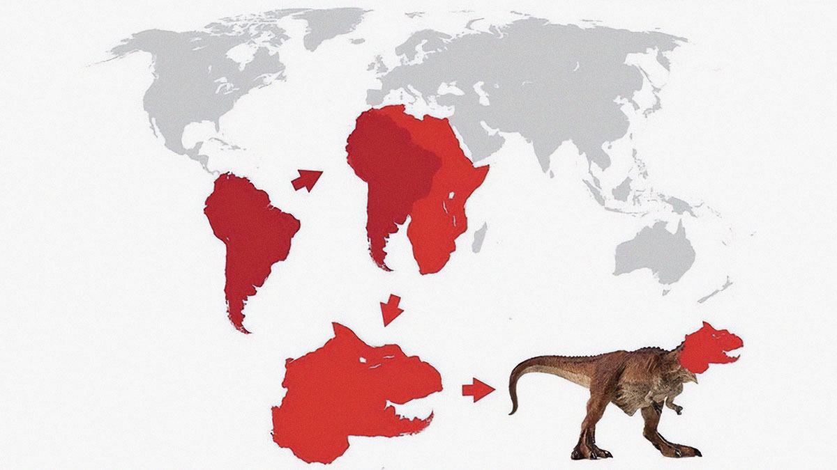
    From among these wonderfully useless maps, I think this one might be the uselessest.

    View more comments
    #36

    U.S. States, But With Some Letters Missing For Your Amusement

    Funny map of the United States with humorous state name variations, showcasing a quirky geography map concept.

    Terrible Maps Report

    #37

    The Nearest Country To Each Portuguese Region

    Map humor showing the country of Spain distorted with exaggerated borders in a funny geography illustration.

    Terrible Maps Report

    #38

    Public Toilets In The United Kingdom In 1540

    Vintage style funny map showing public toilets locations in the United Kingdom in 1540 as a humorous geography map.

    Terrible Maps Report

    #39

    South Korea Takes The Idea Of Political Left vs. Right Very Seriously (2025 South Korean Presidential Election Results)

    Humorous map of South Korea with regions marked in blue and red illustrating funny geography concepts.

    Terrible Maps Report

    XenoMurph
    Community Member
    4 months ago Created by potrace 1.15, written by Peter Selinger 2001-2017

    So the people on the right vote left, and the people on the left vote right? So they are the perfect centreist country?

    View more comments
    #40

    Europe’s Most Famous Composers

    Map of Europe with portraits of famous composers humorously placed according to their countries in funny maps collection.

    Terrible Maps Report

    Apatheist Account2
    Community Member
    4 months ago Created by potrace 1.15, written by Peter Selinger 2001-2017

    This is fairly meaningless if you don't know who they are. Most are rather more famous for their sound than their image.

    View more comments
    #41

    European Countries And Their National Animals

    Map of Europe featuring animals representing different countries in a funny and unusual geography map style.

    Terrible Maps Report

    Rick Murray
    Community Member
    4 months ago Created by potrace 1.15, written by Peter Selinger 2001-2017

    British bulldog? Excuse me: English lion, Welsh dragon, Scottish unicorn.

    WindySwede
    Community Member
    4 months ago Created by potrace 1.15, written by Peter Selinger 2001-2017

    wrong animal i sweden.. European Moose, Alces alces.

    Load More Replies...
    Tim Gibbs
    Community Member
    4 months ago Created by potrace 1.15, written by Peter Selinger 2001-2017

    Why don’t I see a dragon 🐉 for Wales 🏴󠁧󠁢󠁷󠁬󠁳󠁿 and a unicorn 🦄 for Scotland 🏴󠁧󠁢󠁳󠁣󠁴󠁿?

    Ellinor
    Community Member
    4 months ago Created by potrace 1.15, written by Peter Selinger 2001-2017

    Our animal may not be menacing or imposing, but Roosters are still worthy !

    Rick Murray
    Community Member
    4 months ago Created by potrace 1.15, written by Peter Selinger 2001-2017

    Annoy a chicken and you'll quickly learn that the beak is a finely honed weapon.

    Load More Replies...
    Mel in Georgia
    Community Member
    Premium
    4 months ago Created by potrace 1.15, written by Peter Selinger 2001-2017

    I see you, Algeria - would so love to have the Fennec fox as a national animal!

    Michelle Pitsiokos
    Community Member
    Premium
    4 months ago Created by potrace 1.15, written by Peter Selinger 2001-2017

    I woild love to have a poster size of this!

    Load More Replies...
    Glix Drap
    Community Member
    4 months ago Created by potrace 1.15, written by Peter Selinger 2001-2017

    You missed the unicorn off Scotland.

    Alexia
    Community Member
    4 months ago Created by potrace 1.15, written by Peter Selinger 2001-2017

    Lynx is the unofficial symbol animal for Romania; however, brown bear might also compete for this place, considering the huge number of these animals (largest in Europe)

    Michelle Pitsiokos
    Community Member
    Premium
    4 months ago Created by potrace 1.15, written by Peter Selinger 2001-2017

    Australia...where every animal will bite, chew, or squeeze you!

    Nikolka
    Community Member
    4 months ago Created by potrace 1.15, written by Peter Selinger 2001-2017

    Czech Republic is funny. Lion, we don't have them here, our most dangerous and vicious predator is CAT!!!

    Winnie the Moo
    Community Member
    4 months ago Created by potrace 1.15, written by Peter Selinger 2001-2017

    Yeah, the Dutch national animal is the lion, not the Grutto (though it is the national bird)

    Saint_Zipcodus
    Community Member
    4 months ago Created by potrace 1.15, written by Peter Selinger 2001-2017

    I'd be so proud to have a fennec fox as my national animal

    PeepPeep the duck
    Community Member
    4 months ago (edited) Created by potrace 1.15, written by Peter Selinger 2001-2017

    Ok that explains the areas in the history of my people making bears dance for money :( I was always why the hell were Gypşies hurting bears so much etc but they are that areas equivalent to kangaroos in Aus

    Tom Brincefield
    Community Member
    4 months ago Created by potrace 1.15, written by Peter Selinger 2001-2017

    Once most of the wolves in Europe were killed off, the next predator in line moved in.

    Load More Replies...
    OneHappyPuppy
    Community Member
    4 months ago Created by potrace 1.15, written by Peter Selinger 2001-2017

    Since when is the national animal of Serbia a grey wolf?

    Chewie Baron
    Community Member
    Premium
    4 months ago Created by potrace 1.15, written by Peter Selinger 2001-2017

    Denmark should have a red squirrel. https://en.wikipedia.org/wiki/List_of_national_animals

    Pernille
    Community Member
    4 months ago Created by potrace 1.15, written by Peter Selinger 2001-2017

    As a dane I can assure you that the list is wrong. The mute swan is indeed our national animal, beautiful on the outside, aggressive, vengeful, and dominant on the inside.

    Load More Replies...
    Verena
    Community Member
    4 months ago Created by potrace 1.15, written by Peter Selinger 2001-2017

    Very hard to identify. What's those for the Netherlands, Belgium and Luxemburg?

    View more comments
    See Also on Bored Panda
    #42

    States That Are Clearly In The Midwest

    Map of the United States showing states marked as not sure if they belong to the Midwest in a funny geography map.

    Terrible Maps Report

    Mel in Georgia
    Community Member
    Premium
    4 months ago Created by potrace 1.15, written by Peter Selinger 2001-2017

    TBF, the states that were considered Midwest before the country expanded westward were definitely toward the east. (Ohio, Indiana, Missouri, Iowa ...)

    View more comments
    #43

    Average Size Of A Pizza

    Map showing average pizza size across Italy's provinces using colored circles, a funny and unusual geography map.

    Terrible Maps Report

    #44

    Road Trip, Anyone?

    Map showing a 4,731-mile route across the US and Canada including unusual place names Pee Pee Creek and Pee Pee Island.

    Terrible Maps Report

    Skara Brae
    Community Member
    4 months ago Created by potrace 1.15, written by Peter Selinger 2001-2017

    The one on the left is P o o P o o Point, an outcrop on Tiger Mountain near Issaquah, Washington (state). It's a popular spot for hang gliders to jump from. https://www.wta.org/go-hiking/trip-reports/trip_report.2015-03-04.7676213335

    View more comments
    #45

    Eurovision: The Country Each Nation Received The Most Points From Over The Last 20 Year

    Map of Europe with countries filled in by different national flags in a funny and unusual geography map style.

    Terrible Maps Report

    #46

    Map Of The Shrek Republic

    Map of Central Europe altered to resemble Shrek with text Shrek Republic, funny and horrible map concept.

    Terrible Maps Report

    Lara Verne
    Community Member
    4 months ago Created by potrace 1.15, written by Peter Selinger 2001-2017

    Prague is located near Sherk's right eye

    View more comments
    #47

    Believe It Or Not, Portugal Is Actually Smaller Than Spain

    Funny map comparing Spain's size to Michigan, highlighting humorous and unusual geography differences.

    Terrible Maps Report

    #48

    How Many Skyscrapers Are In Each Us State

    Map showing the number of skyscrapers by US state, highlighting states with over 100 skyscrapers in dark brown.

    Terrible Maps Report

    Mjskywalk
    Community Member
    4 months ago Created by potrace 1.15, written by Peter Selinger 2001-2017

    There are only 2 escalators in the entire state of Wyoming.

    View more comments
    #49

    France Pizza Map

    Heat map showing median income distribution across French communes in 2015 with varying income levels highlighted in shades.

    Terrible Maps Report

    Multa Nocte
    Community Member
    4 months ago Created by potrace 1.15, written by Peter Selinger 2001-2017

    My region of France is dark red and it's amazingly true how much pizza is sold here. I would never have believed it.

    View more comments
    #50

    Really Pleased With My New IKEA Globe That Shows Earth At Night Time

    Black globe with no visible map details displayed on a table with bed textiles and dishware nearby.

    Terrible Maps Report

    #51

    Interestingly, Egypt Is Smaller Than The United States, Russia, And China Combined

    Color-coded world map showing different countries for funny maps related to geography and humor.

    Terrible Maps Report

    See Also on Bored Panda
    #52

    Would It Be Socially Acceptable To Name Your Child After This State?

    US map color-coded with categories from acceptable to w*f, illustrating humorous and unusual geographic distinctions.

    Terrible Maps Report

    Raven Sheridan
    Community Member
    4 months ago Created by potrace 1.15, written by Peter Selinger 2001-2017

    I'd like to introduce my sister-daughter, Kentucky.

    View more comments
    #53

    If You're Asked To "Put Your Hands Up" And You're Not Sure Why

    Venn diagram humorously categorizing people who say put your hands up, combining bank robbers, preachers, DJs, cops, and rollercoasters.

    Terrible Maps Report

    #54

    Scandinavia Swapped With The Mediterranean

    Satellite view of Europe highlighting geographical features in a funny and horrible maps collection for geography enthusiasts.

    Terrible Maps Report

    Niki
    Community Member
    4 months ago Created by potrace 1.15, written by Peter Selinger 2001-2017

    Well, it opens up the upper floors a bit.

    View more comments
    #55

    Us States If They Were All Named Like West Virginia

    Map of the US showing states humorously renamed variants of Virginia in a funny and horrible geography-themed map.

    Terrible Maps Report

    Piwakawaka
    Community Member
    4 months ago Created by potrace 1.15, written by Peter Selinger 2001-2017

    Now do the world if all named like New Zealand's islands.

    #56

    Distribution Of Lighthouses In Africa

    Map of African countries showing those with and without lighthouses as a funny map not found in geography books.

    Terrible Maps Report

    Auntriarch
    Community Member
    4 months ago Created by potrace 1.15, written by Peter Selinger 2001-2017

    Did nobody ask eSwatini and Lesotho? Or did they assume they were lakes

    View more comments
    #57

    The Top 5 States In India

    Map of India highlighting the top 5 states in blue with humorous and unusual geographical presentation.

    Terrible Maps Report

    #58

    World Map According To The Brazilian Government

    Inverted world map with countries labeled, showing a humorous and unusual geography perspective for funny maps.

    Terrible Maps Report

    #59

    Map Of Dandelion Distribution In The UK

    Map of the United Kingdom showing likelihood levels in different regions with color-coded legend in a funny geography map style.

    Terrible Maps Report

    #60

    Europe With Every Island And Peninsula Removed... Except Cyprus

    Satellite view of a geographical region showing green landscapes and water bodies, illustrating funny maps for humor and geography.

    Terrible Maps Report

    panther
    Community Member
    4 months ago Created by potrace 1.15, written by Peter Selinger 2001-2017

    Why not Cyprus? Why is it so special?

    View more comments
    #61

    Map Showing The Average Number Of Bowel Movements Per Week

    Map showing average number of bowel movements per week across Europe with color-coded data and country labels.

    Terrible Maps Report

    See Also on Bored Panda
    #62

    How Far Are You From India, Measured In Units Of India?

    World map showing distance zones from India using color-coded layers in a humorous and unusual geography map style.

    Terrible Maps Report

    #63

    Eye Colour Of Us Governors

    US map with states colored brown, blue, and green illustrating a funny and unusual geography map concept.

    Terrible Maps Report

    #64

    Which Way Do Windows Open In Europe?

    Map of Europe showing window opening directions by country, a funny map illustrating cultural differences in a geography context.

    Terrible Maps Report

    Verena
    Community Member
    4 months ago (edited) Created by potrace 1.15, written by Peter Selinger 2001-2017

    In the Netherlands windows of houses usually open outward (unless built after 2000). It really annoyed me after moving from Germany (for work) some 30 years ago. It requires a glass cleaner with a long stick - either a human one, dropping by once a month or a trip to the DIY-shop and some lessons in ladder artistics. The reason: In a windy and rainy country you very quickly learn the advantages of a window blown shut instead of open.

    View more comments
    #65

    The Most Commonly Spoken Language Besides Spanish In Each State

    Funny map of the United States showing the entire country labeled as English in a humorous geography illustration.

    Terrible Maps Report

    Gavin Johnson
    Community Member
    4 months ago Created by potrace 1.15, written by Peter Selinger 2001-2017

    You say English but as a speaker of the Queen’s English, or is it King’s English now, I can assure you that some areas use a very loose approximation of ‘English’.

    View more comments
    #66

    Burn It With Fire

    Humorous maps showing distorted US states renamed Califournia and Fourida as funny geography map examples

    Terrible Maps Report

    panther
    Community Member
    4 months ago Created by potrace 1.15, written by Peter Selinger 2001-2017

    One Florida is bad enough the world doesn't need four.

    View more comments
    #67

    Getting His Steps In

    Map showing Bigfoot report locations densely clustered across the United States with icons marking sightings.

    Terrible Maps Report

    Niki
    Community Member
    4 months ago Created by potrace 1.15, written by Peter Selinger 2001-2017

    It's safe to say he probably doesn't speak French or Spanish, hence the few sightings in Quebec and Mexico.

    View more comments
    #68

    Map Showing The Australo-Hungarian Empire In 1783

    Map showing a humorous and historical version of the Austro-Hungarian Empire with funny regional labels.

    Terrible Maps Report

    Miki
    Community Member
    4 months ago Created by potrace 1.15, written by Peter Selinger 2001-2017

    muricans will believe thats true :D

    View more comments
    #69

    Most Frequently Used Words In Dating Profiles, By State

    Map of the United States with a large black letter I and a small green Idaho labeled the word the, a funny map concept.

    Terrible Maps Report

    #70

    Can You Legally Own A Monkey?

    Map of North America showing gun law restrictions by state with color codes for no restriction, permit required, partial ban, and full ban.

    Terrible Maps Report

    Khavrinen
    Community Member
    4 months ago Created by potrace 1.15, written by Peter Selinger 2001-2017

    Can you own a monkey? Varies by state. *Should* you own a monkey? No, everywhere.

    View more comments
    #71

    European Countries With Names Ending In ‘Ia’

    Map of Europe highlighting several countries in orange, featured in funny maps not found in geography books.

    Terrible Maps Report

    See Also on Bored Panda
    #72

    The Us, China, India, Canada, Brazil, And Australia Can Fit Inside Europe

    Map overlay comparing Europe with Russia in a colorful, humorous style showing size differences and borders.

    Terrible Maps Report

    Raven Sheridan
    Community Member
    4 months ago Created by potrace 1.15, written by Peter Selinger 2001-2017

    Australia is not that kind of country. Or at least take us out to dinner first.

    View more comments
    #73

    Europe’s Most Famous Leaders

    Europe map collage filled with historical figures and a cartoon character illustrating funny maps concept.

    Terrible Maps Report

    MoBeLa
    Community Member
    4 months ago Created by potrace 1.15, written by Peter Selinger 2001-2017

    Germany had a more famous one, but I’m glad they left him off the map.

    View more comments
    #74

    Seems Legit

    Map showing America's UFO sightings by state and hour, highlighting peak times and regional sighting rates from 2000 to 2014.

    Terrible Maps Report

    #75

    Participants Were Asked To Find Iran On A Map

    Map showing incorrect and correct placements of Iran with data points highlighting geography mistakes and accuracy in identification.

    Terrible Maps Report

    #76

    Here’s A Map You Didn’t Know You Needed

    Map showing nearest major U.S. cities to different global regions in a funny geography-themed illustration.

    Terrible Maps Report

    PattonPawter
    Community Member
    4 months ago Created by potrace 1.15, written by Peter Selinger 2001-2017

    Sooo what about that point in the middle of India?

    #77

    Is Your Country Closer To South Africa Or Lesotho?

    World map highlighting countries closer to South Africa or Lesotho in a funny and unusual geography map style.

    Terrible Maps Report

    #78

    A Useful Map For New Yorkers In La

    Map humor showing mislabeled boroughs of New York overlaying a Los Angeles map in funny geography maps collection

    Terrible Maps Report

    #79

    Without Touching A Single Piece Of Land, You Can Sail From India To The USA In A Completely Straight Line

    Unusual world map showing a long, convoluted shipping route between two distant points, a funny geography map example.

    Terrible Maps Report

    KnightOwl86
    Community Member
    4 months ago Created by potrace 1.15, written by Peter Selinger 2001-2017

    Weirdest looking 'straight' line I've ever seen..

    View more comments
    #80

    I Enjoyed My Secondment Last Month

    Map showing the top 10 most visited cities in Europe with visitor numbers, featured in funny and horrible maps collection.

    Terrible Maps Report

    Ace
    Community Member
    4 months ago Created by potrace 1.15, written by Peter Selinger 2001-2017

    The only way to make any sense of this would be to assume that the cities mentioned are those most visited by the population of the countries they;re pinned to. Then ignore the rankings or whatever the number prefix are supposed to be.

    View more comments