Get Premium
Dark mode theme is available exclusively for premium users. Learn more about the benefits of subscribing.
No fees, cancel anytime.

 Dark Mode Ad-Free Browsing Unlimited Content
 Ad-Free Browsing Unlimited Content Dark Mode
Join 1.2 million Panda readers who get the best art, memes, and fun stories every week!
Easily navigating the world is one of the greatest gifts to the modern world. We developed tools to help with that, and one thing stands above all—a map. Throughout history, ancient maps of the world have been invaluable exploration tools. From the artistic designs of medieval maps to the earliest known primitive representations of the globe, these charts offer a glimpse into ancient history and our ancestors' evolving understanding of our planet.
Beyond their practical usefulness, these maps could also considered unusual works of art. The artistry and craftsmanship that created these complex illustrations of our world is something else. Each map is a tribute to the creativity and skill of its maker, offering us a window to see the cultures and societies that existed before us.
Ancient world maps are not just documents of geography but also evidence of human creativity and advancement. With each discovery and technological progress, maps had to be updated. The first map of the world was a starting point, and generations of cartographers improved and expanded upon these early models.
Now, it's your turn to explore these ancient world maps. Delve into the past and marvel at the creativity and artistry of these charts. Share with friends and family, and let them participate in this voyage through time and the world!
This post may include affiliate links.
In the sixth century BC, the world's earliest known map was created in Babylon. The map places Babylon in the middle of a region that doesn't go past Mesopotamia's borders. A "bitter river" circles the globe. They thought there was no way to get to the seven points beyond the river.
World atlas by Johannes Ruysch, created in 1507. This map displays one of the first representations of the New World.
Ptolemy's world map designed in 150 AD. For the first time in history, longitudinal and latitudinal lines were added to a world map.
The world map was created in the second century BC by Posidonius.
This map broadens the early Greek understanding of the world to include Alexander the Great's discoveries.
The entire map is very lengthy, stretching from Iberia to India, with Rome serving as the globe's geographic center.
In ancient times, the concept of the world was a combination of geography, cosmology, and cultural beliefs. Old maps of the world show us how people of that time perceived our planet Earth. Before the technology we have to help us today, ancient cultures viewed the world based on elements of mysticism and religious beliefs. For example, there was a time when the theory of a flat Earth was the most scientifically advanced concept.
To further prove how different science was in ancient times, there was also a time when people believed that Earth was the center of the universe. Just like with traditions, cultural diversity influenced scientific beliefs at that time. Which makes you wonder, how did any of the people living at that time reach their desired destination? You'd have to travel back in time and ask them because we have no idea either.
Martin Behaim constructed a projection of the Erdapfel globe in Germany in 1492. The Erdapfel is the oldest globe that is currently known to exist. It depicts the world as spherical, with uncharted America as an empty ocean.
It's "Erdapfel" (literally "earth apple"), with an R after the initial E
Samuel Dunn's map of the world, drawn in 1794 AD. Dunn was the first to map out the entire world using Captain James Cook's discoveries as his guide.
Isidor of Seville created the "T and O" map in the seventh century.
With Jerusalem at its center, these maps divided the globe into three equally spaced regions: Asia, Europe, and Africa.
The earliest map still in existence, known as the Cantino planisphere or Cantino world map, depicts Portuguese discoveries in the east and west. It was successfully transported from Portugal to Italy in 1502 by the agent for the Duke of Ferrara, Alberto Cantino, who bears his name. Along with showing Africa, Europe, and Asia, it also depicts the Caribbean islands and what appears to be the Florida shoreline. The map is particularly noteworthy for depicting a sketchy record of the Brazilian coast, which Portuguese explorer Pedro lvares Cabral discovered in 1500.
The first authentic modern atlas is thought to be the Theatrum Orbis Terrarum, also known as "Theatre of the World." It was created by Abraham Ortelius and first published on May 20, 1570, in Antwerp. It was made up of a number of homogeneous map sheets and supporting texts that were bonded together and printed using copper printing plates that were specially engraved. Some people refer to the Ortelius atlas as a compendium of sixteenth-century mapping. Many of the maps in his atlas were derived from sources that are either extinct or very uncommon.
The oldest surviving items always bring a dash of awe to our faces. That’s even more the case with old cartography things, which are incredibly fragile. Which brings us to the question— what’s the oldest surviving map of the Earth?
It is from ancient Babylon, a city from over 2,500 years ago. The Imago Mundi (Babylonian Map of the World) was made around the 6th century BCE. Even though it might look a bit basic compared to maps today, it's still extraordinary to see how people before our time viewed the world.
Kunyu Wanguo Quantu, printed by Italian Jesuit missionary Matteo Ricci at the request by Wanli Emperor in 1602, is the first known European-styled Chinese world map (and the first Chinese map to show the Americas). The map is written in Classical Chinese and includes extensive annotations and descriptions of different geographical areas as well as a brief history of the discovery of the Americas, polar projections, a scientific explanation of parallels and meridian lines, and evidence that the Sun is larger than the Moon. Ricci positioned China (also known as "the Middle Kingdom") at the center of the globe in accordance with Chinese cartographic tradition. This map is a crucial indicator of how much Chinese knowledge of the world has grown, as well as a prime illustration of direct cultural fusion between China and Europe. Additionally, it was exported to Japan and Korea.
This map was created between 1457 and 1459 by the Venetian monk Fra Mauro. Andrea Bianco, a sailor, and cartographer assisted with the creation of this map, which showcases his in-depth knowledge of the globe.
Andrea Bianco's atlas of 1436 comprises ten leaves of vellum, measuring 29 cm × 38 cm (11 in × 15 in), in an 18th-century binding. A description of the Rule of Marteloio for resolving the course is included on the first leaf, along with the "circle and square," two tables, and two further diagrams. The eight leaves after that are different navigational maps. The Ptolemaic world map, using Ptolemy's first projection, is included on the final leaf. Some people think that Bianco's maps were the first to accurately depict the Florida coast because a macro-peninsula is connected to a sizable island called Antillia. Additionally, Bianco and Fra Mauro worked together to create the Fra Mauro world map in 1459.
The sole surviving map created by Juan de la Cosa, a Spanish cartographer, explorer, and conquistador, is the Mappa Mundi from 1500. Juan de la Cosa was born in Santoa in the northern autonomous area of Cantabria. It is the first known example of a European map of the Americas. It is currently housed in Madrid's Museo Naval. Humboldt provides reproductions of it in his Atlas géographique et physical.
One of the final globe maps to show the "Dragon's Tail," the final remnant of Ptolemy's landlocked representation of the Indian Ocean from over 1,500 years earlier, reaching southward from Asia's extreme easternmost point.
The oldest surviving city map takes us way back in time to ancient Mesopotamia, around 1400 BCE. Archeology unearths many ancient wonders, but perhaps one of the most important things found was a simple clay tablet. It shows the city of Nippur, one of the most essential cities in Babylonia. This ancient world map gave us a rare peek into what cities looked like thousands of years ago, and helped us understand the society of Babylonia.
Hendrik Hondius drew the world map Nova Totius Terrarum Orbis Geographica ac Hydrographica Tabula in 1630, and the atlas Atlantis Maioris Appendix included it in Amsterdam the following year. There are pictures of the four elements: fire, air, water, and land. Julius Caesar, Claudius Ptolemy, and the atlas's first two publishers, Gerard Mercator and Jodocus Hondius, Hendrik's father, are all depicted on the atlas' four corners.
Nicolaes Visscher produced Orbis Terrarum Nova et Accuratissima Tabula, an etched double hemisphere map, in Amsterdam in 1658. Additionally, it includes scaled-down projections of the north and south poles. The painter Nicolaes Berchem drew four mythical images, one in each corner, to decorate the border, depicting Zeus, Neptune, Persephone, and Demeter. It is a vintage illustration of elaborate Dutch globe maps.
The Bunting Clover Leaf Map, created by Heinrich Bunting in Germany in 1581, is a later Christian map. This map represents the world as an extension of the Christian trinity, with Jerusalem serving as the hub that binds it all together, rather than how it actually is.
see and that's how Cristopher Columbus thought that you could get to Asia from Europe without turning.
The map created in 1507 by Martin Waldseemüller and Matthias Ringmann. The small strip of the eastern coast was all that was displayed on this earliest map of the New World, otherwise referred to as "America."
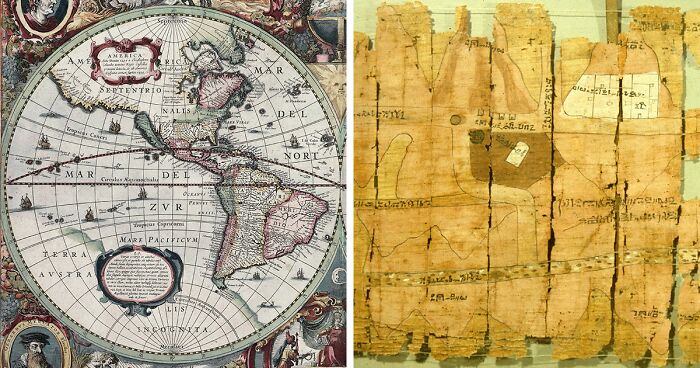
The Wadi Hammamat gold mine is depicted on the Turin Papyrus (east), which B. Drovetti discovered at Deir el-Medina around 1820 BC (Egypt).
Ancient Egyptian mining chart for Ramesses IV's quarrying expedition, from the 12th century BC, found among Turin Papyrus fragments (New Kingdom)
A cylindrical map projection, known as the Mercator projection, was first used in a globe map by Flemish geographer and cartographer Gerardus Mercator in 1569. The Mercator projection distorts the size and shape of large objects as the scale increases from the Equator to the poles, where it becomes infinite, whereas the linear scale is constant in all directions around any point, preserving the angles and shapes of small objects (which makes the projection conformal).
The Tabula Rogeriana by Al-Idrisi, drawn in 1154. Based on the accounts of Arab traders who had traveled the globe, this map was produced. It was the world's most detailed and accurate map at the time. The map displays a lot of Europe and Asia, but it only shows the northern regions of Africa.
Albertinus de Virga created the De Virga world map between 1411 and 1415. A 1409 map of the Mediterranean region, similarly produced in Venice, is credited to Venetian Albertin de Virga. A circular global map measuring 69.6 cm by 44 cm (27.4 in x 17.3 in) has been drawn on parchment. It comprises of the actual map, which measures 44 cm (17 in) in diameter, plus an addition that includes two tables and a calendar.
The Anglo-Saxon Cotton Map, created between 1025 and 1050 AD. The highest region of this map is made up of the eastern regions of the earth. By misinterpreting descriptions of the Red Sea, the artist mistakenly painted every river in Africa red.
Dura-Europos parchment, showing a part of the Black Sea coast, around 200 AD. It was found in 1923 by F. Cumont in Syria.
The Piri Reis map was produced by Ottoman Turkish admiral and geographer Piri Reis in the 16th century. The third of the map that has survived depicts parts of the western coasts of Europe and North Africa rather accurately, and the Brazilian coast is also clearly visible. The mythical island of Antillia, as well as several other Atlantic islands, including the Azores and Canary Islands, are pictured. The map is notable for showing what appears to be an extension of the American continent to the southeast, which some have argued is proof that Antarctica was known to exist before other continents.
World map by Cosmas Indicopleustes from the sixth century, which shows the globe as a rectangular-shaped surface.
Around Shaanxi, China, in the year 1137, a stone was engraved with the "Map of the Track of Yu Gong."
This precisely drawn map, which shows the size of the Chinese empire, was created using a rectangular grid.
The world map was created by Mahmud al-Kashgari in the eleventh century. The ancient city of Balasagun, which once stood where Krygyzstan does today, is the focal point of this map. It contains locations like Gog and Magog that are said to make an appearance in the end times.
The Psalter World Map, drawn by an unknown medieval monk in 1260 AD. Maps from this time period usually place the east at the top of the globe, where the sun rises and Jesus watches over the world.
Pietro Vesconte, an Italian geographer, drew this map of the world in 1321. After centuries of T and O designs, Vesconte restored precision to maps by utilizing nautical charts to map the seas.
The Kangnido World Map was created by Korean officials in 1402 AD. The Joseon Dynasty combined Chinese maps with information about the West that they learned from Mongolian Muslims to create this map.
The Genoese map was created in 1457 based on Niccolo da Conti's descriptions. After the first commercial connections between China and Mongolia were established, this map illustrates a developing European understanding of the Asian continent.
The world map created in 1689 by Gerard van Schagen. With the exception of a few ambiguously blank areas in the Americas, most of the planet had by this point been mapped.
The Catalan World Atlas was produced by the Majorcan cartographic school and is attributed to Cresques Abraham. The texts on the first two leaves are in Catalan and deal with cosmology, astronomy, and astrology. Illustrations are included with these texts. The spherical shape of the Earth and the current status of the known globe are emphasized in the words and illustrations. They also teach sailors how to tell time at night and about tides.
The Borgia map is an early 15th-century world map that is mostly decorative. It was engraved on a metal plate.
Nicolay de Caveri drew the Caverio Map, also known as the Caveri Map or Canerio Map, sometime around 1505. It was most likely drawn in Lisbon by the Genoese cartographer Canveri and it's eerily similar Cantino map in Genoa. It was one of the primary resources used to produce the Waldseemüller map in 1507 and provides a remarkable amount of information regarding the east coast of North America.
The world map created by Hecataeus of Miletus in the fifth or sixth century BC.
Around the Mediterranean Sea, Hecataeus divides the world into three regions: Europe, Asia, and Libya. His planet is a round disc encircled by water.
Beatus of Libeana, an Asturian monk who lived in the eighth century AD, created this view of the universe. Based on the T and O pattern, Beatus's map is referred to as a "Christian Map."
World map created in Germany during the 13th century by Gervase of Ebstorf. Jerusalem serves as the geographic center of the Ebstorf Map, which is based on the T and O model from the Middle Ages. It is embellished with representations of biblical tales from various geographical locations.
The Mer des Hystoires world map was drawn in 1491. Some monks continued to draw T and O maps throughout the age of exploration, with Jerusalem depicted as the earth's center and paradise depicted as a genuine place on the planet's eastern side.
Albi’s Mappa Mundi, from an 8th c. The manuscript was found in the St. Cecilia cathedral of Albi, France.
A mosaic depiction of Jerusalem from the sixth century was discovered under the floor of St. George's Church in Madaba, Jordan. The Damascus Gate, St. Steven's Gate, Golden Gate, Mount Zion Gate, Citadel (Tower of David), Church of the Holy Sepulcre, and Cardo Maximus are among the well-known Old City buildings shown on the map.
The Padrón Real, created in 1527 by Portuguese geographer Diogo Ribeiro while working for Spain, is widely considered to be the first global map based only on empirical latitude observations. Six copies have been attributed to Ribeiro, including ones at the Vatican City Biblioteca Apostolica Vaticana and the Weimar Grand Ducal Library (1527 Mundus Novus). The data obtained during the Magellan-Elcano expedition around the world had a considerable impact on the construction of the map (Mapamundi). Diogo's map clearly depicts the coastlines of Central and South America. Australia and Antarctica are absent, while the Indian subcontinent is too small to be included. For the first time, the actual extent of the Pacific Ocean is depicted on a map as well.
The Hereford Mappa Mundi, drawn by Richard of Haldingham in the 14th century.
Jerusalem is located in the east at the top and center of this T and O map. The Garden of Eden is represented by the circle on the map's extreme south side.
Chinese map from the late 14th century called the Da Ming Hu Yi Tu. The world is depicted on this map as it seemed to China during the Ming Dynasty, with China ruling a vast majority of the planet and all of Europe crammed into a small area in the west.
I would love to go back to a time where the nearest town was at least half a day ride and going to another country meant days at sea or on sleeper trains.
I would love to go back to a time where the nearest town was at least half a day ride and going to another country meant days at sea or on sleeper trains.


 No fees, cancel anytime


")
")