Get Premium
Dark mode theme is available exclusively for premium users. Learn more about the benefits of subscribing.
No fees, cancel anytime.

 Dark Mode Ad-Free Browsing Unlimited Content
 Ad-Free Browsing Unlimited Content Dark Mode
Join 1.2 million Panda readers who get the best art, memes, and fun stories every week!
Geography shapes human life in multiple ways, from the resources we have available all the way to our diverse cultures. How we study it has evolved significantly over the years, moving from basic drawings to more sophisticated high-resolution satellite maps and interactive GIS platforms. In this collection, you’ll find 50 photos of interesting geography from around the world. The images not only highlight breathtaking landscapes and oceans, but also a variety of maps and charts. They also give us a fascinating glimpse into how we interact with the world around us and how geography influences our daily lives.
This post may include affiliate links.
Imagine if Los Angeles was built like Barcelona. Dense 15 million people metropolis with great public transportation and walkability.
They wasted this perfect climate and perfect place for city by building a endless suburban sprawl.
If that is a real picture of LA, then I know what my Hell will look like if the Christians are right.
Maps play a crucial role in the study of geography. From cave wall drawings to inscribed clay tablets, a variety of maps have existed for decades. The oldest ones in the world date back to the 9th Century and were created in Babylon. By the 20th century, satellite imagery and aerial photography had transformed mapping into a sophisticated and precise science.
Funny, I have an overwhelming compulsion to make a mashed potato replica of this very site . . . .
Fog is the primary source of water in the site, accounting for a unique environment in which endemic invertebrates, reptiles and mammals adapt to an ever-changing variety of microhabitats and ecological niches.
This is why #5 is possible… their forests are untouched because no one really lives out there.
this is simplified. Here's a picture that is actually more accurate. Because UK still uses imperial system FT_gltGWAA...5c670d.jpg 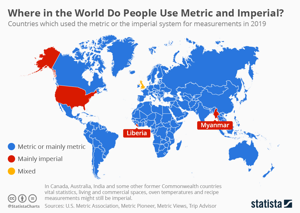
It might be beautiful from above, but if you get caught in these waves, your vessel can easily turn upside down or lose its way.
In addition to making up over 97% of the Earth’s water, oceans also cover 71% of the planet’s surface. The Pacific Ocean, which is the largest of the five major oceans, makes up 31% of the surface and averages about 13,000 feet in depth. Second in size is the Atlantic Ocean, which covers 20% of the planet’s surface. Surprisingly, only 5% of the world's oceans have been explored, with the other 95% remaining a complete mystery.
The Center for Disease Control in the US put out a statistical report which included the following: Women's Mean age at first birth increased over time and rose 0.9 year from 26.6 in 2016 to 27.5 in 2023.
i think its called megalopolis, if my memory of geography classes in france is correct ..... I checked, naming the area "megalopolis" started in 1961. Apparently nowadays americans use the fabricated name BosWash
I guess all that Southern Fried Food and all those g*ns isn’t the secret to immortality.. looking at you South.. lol.
I probably ought to go for a walk, I saw the city lights as explosions...


 No fees, cancel anytime


")
")