ADVERTISEMENT
Article created by: Justinas Keturka

Where would you start if you were looking for a treasure? Well, from what we learned in Jumanji, we probably need a map. In fact, maps, the precious representation of information, are key to so many secrets of the world, whether it’s the Earth, our history, politics, sociology, or anything, really.

Thanks to this corner of Reddit known for being the ultimate destination for fans of cartography, we can devour an endless variety of maps that all differ in information, style, size and other features. With 1.8 million members of the community, it’s now turning into one of those Reddit powerhouses that gives the best of online content.

Scroll down through the new batch of maps below and after you’re done, be sure to share our previous posts with the most unique and informative diagrammatic representations you may not have even known existed, here, here and here.

#1

The Baltic Way. On 23 August 1989, Two Million People Joined Their Hands To Form A Human Chain Spanning 675.5 Km Across The Three Baltic States. The Protest Was Against The Soviet Occupation, And To Support The Independence Movements Of The Three States

Map of the Baltic Way showing human chain linking Estonia, Latvia, and Lithuania in 1989 for freedom.

RepublicOfEurope Report

Lil be lil
Community Member
6 months ago Created by potrace 1.15, written by Peter Selinger 2001-2017

Love this !!!! We should protest like this in 'Murica.

RELATED:
    #2

    "Head North, Young Man..."

    Map of Antarctica highlighting the confusing directions labeled North and South on the continent's coastlines.

    5_Frog_Margin Report

    #3

    Cyclist Recreates Nirvana’s “Nevermind” Album Cover

    Map showing Adelaide city boundaries creatively shaped like a person, an example of informative maps changing perspective.

    TRiskProduction Report

    #4

    Topography Of China

    3D printed topographic map model in red, green, and gray colors showcasing geographic elevation details.

    MeronDC Report

    ADVERTISEMENT
    #5

    Atheists Are Prohibited From Holding Public Office In 8 US States

    Map showing 8 US states where atheists are prohibited from holding public office, highlighting regional legal restrictions.

    clayagds99 Report

    ADVERTISEMENT
    #6

    The Topography Of Ukraine

    Detailed relief map of Ukraine showing elevation and terrain features, an informative map that may change your perspective.

    boytutoy Report

    #7

    Map Showing Netherland's Progress In Flood Management (Source: Earthmagazine)

    Side-by-side informative maps showing land changes in the Netherlands from year 1300 to today, highlighting geographical transformation.

    WildestEconomist Report

    #8

    Is Escape A Crime?

    Map showing European countries where escaping from prison is not a crime, highlighting legal differences in Europe.

    Mmaps_interlude Report

    ADVERTISEMENT
    #9

    All The Countries That Have Gained Independence From Great Britain

    World map showing countries with their flags and years of independence, an informative map highlighting global history.

    yeetice Report

    Lil be lil
    Community Member
    6 months ago Created by potrace 1.15, written by Peter Selinger 2001-2017

    Canada wasn't independent till 1931?

    ADVERTISEMENT
    #10

    Most Popular Language On Duolingo

    Color-coded world map showing the most popular languages on Duolingo by country, featuring English, Spanish, French, German, and Swedish.

    Coldcomplex1 Report

    Raymond Core
    Community Member
    6 months ago Created by potrace 1.15, written by Peter Selinger 2001-2017

    Been in Thailand since 1999. In all that time I heard only one Spanish speaker and that was a tourist.

    #11

    Countries With A Higher Life Expectancy Than The United States

    World map highlighting countries with higher life expectancy than the United States using informative maps for perspective.

    burgerking_foot Report

    #12

    The New Longest Possible Train Journey In The World

    Map showing a long transcontinental route across Europe and Asia, featured in informative maps collections.

    htGoSEVe Report

    ADVERTISEMENT
    #13

    The Red Part Contains More People Than The Blue Put Together

    World map highlighting countries in blue with one country marked in red, showing informative maps that might change perspectives.

    AndoMacster Report

    ADVERTISEMENT
    #14

    Russian Military Build-Up Around Ukraine

    Map showing Russian military build-up around Ukraine with troop deployments, military equipment, and key locations highlighted.

    swearcoat Report

    #15

    A Map Visualizing The Armenian Genocide - Started 106 Years Ago

    Map showing changes in Armenian population distribution before 1915 and today, highlighting historical demographic shifts.

    roiaumedejherusalem Report

    #16

    World Map, But It’s Centered On Buenos Aires, Argentina

    Satellite view of a world map showing continents and oceans with detailed land and ice coverage for informative maps perspective.

    burgerking_foot Report

    ADVERTISEMENT
    #17

    London's Piccadilly Tube Station. Piccadilly Circus Is A Road Junction And Public Space Of London's West End In The City Of Westminster. It Was Built In 1819 To Connect Regent Street With Piccadilly

    Detailed vintage map illustration of Piccadilly underground station layout with labeled escalators and entrances shared as an informative map.

    5igorsk Report

    Lil be lil
    Community Member
    6 months ago Created by potrace 1.15, written by Peter Selinger 2001-2017

    👍 seems incredible for 1819.

    ADVERTISEMENT
    #18

    Countries That Have, Or Have Had, Openly Gay Heads Of Government

    Map of Europe highlighting countries with openly homosexual heads of government, an informative perspective on political representation.

    Porodicnostablo Report

    #19

    This Is A Really Fascinating Map. Languages Of Europe Around 600 Ad

    Map showing common European language groups in 600 AD including Slavic, Old Norse, Romance, and Finno-Ugric regions.

    _Hydrohomie_ Report

    #20

    World Map According To China In 1799

    Ancient hand-drawn map with Asian script, one of 35 informative maps shared in a group that might change perspectives.

    imrahul08 Report

    Lil be lil
    Community Member
    6 months ago Created by potrace 1.15, written by Peter Selinger 2001-2017

    Where's America and all the Sea Monsters?

    ADVERTISEMENT
    See Also on Bored Panda
    #21

    US States In Which Homosexuality Was Illegal From 1962 To 2012

    US map series showing the decline of states where homosexuality was illegal from 1962 to 2012, an informative perspective map.

    Mackelowsky Report

    ADVERTISEMENT
    See Also on Bored Panda
    #22

    Map Of The 2191 Meter Deep Krubera Cave. The Deepest Known Cave System In The World

    Topographical map of Krubera-Voronya cave showing underground camps and depth compared to the Eiffel Tower height.

    bacs05rc Report

    Lil be lil
    Community Member
    6 months ago Created by potrace 1.15, written by Peter Selinger 2001-2017

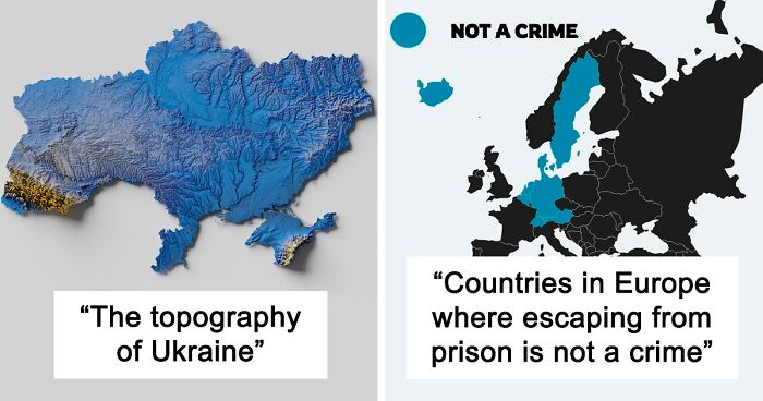
    Is this in Ukraine? Mind blowing! Way to the dream. Center of the Earth!! ( you won't find me there!

    #23

    This Is The Farthest Place On Earth From Any Ocean

    Map showing a red circle centered in Asia illustrating geographic distance and perspective on a global scale.

    MeronDC Report

    Lil be lil
    Community Member
    6 months ago Created by potrace 1.15, written by Peter Selinger 2001-2017

    The middle of everything? It's on the edge of the Middle Kingdom.

    View more comments
    ADVERTISEMENT
    See Also on Bored Panda
    #24

    % Of Europeans Who Would Fight For Their Country

    Map of Europe showing percentage of Europeans willing to fight for their country, highlighting Finland highest and Netherlands lowest.

    adorn_mapper Report

    #25

    Map For Halloween - Every Castle In Europe

    Map showing castles of Europe highlighted in red, an informative map that might change your perspective on things.

    Spatial_Overlay Report

    ADVERTISEMENT
    See Also on Bored Panda
    #26

    Most Obese Countries

    World map highlighting countries with over 30% obesity rates, showing global data on most obese countries by Harvard University.

    No-Ad7595 Report

    Lil be lil
    Community Member
    6 months ago

    This comment has been deleted.

    ADVERTISEMENT
    See Also on Bored Panda
    #27

    School Shootings In Europe Since 2010

    Map of Europe showing school shootings by country since 2010 with color-coded data revealing regional patterns and differences.

    Nic0487 Report

    #28

    Piracy In The 21st Century

    World map showing piracy attack risk zones in the 21st century with Gulf of Guinea highest on informative maps.

    shashsainik Report

    #29

    Grading System In Europe

    Map showing grading systems used across European countries with varied scales, offering an informative perspective on educational differences.

    vladgrinch Report

    ADVERTISEMENT
    See Also on Bored Panda
    #30

    Most Frequent Causes Of Deaths For 50 To 69-Year-Olds. @realworldmaps

    Map showing causes of deaths for 50 to 69 year olds in Europe by cancers and cardiovascular diseases.

    Realworldmaps Report

    ADVERTISEMENT
    See Also on Bored Panda
    #31

    Eu Countries Pushing To Label Nuclear Power As Green Energy

    Map showing EU countries pushing to label nuclear power as green energy with states highlighted by support or opposition.

    PepperBlues Report

    #32

    All Roads Lead To Rome. This Map Is Visualises The Famous Roads Built By The Roman Empire

    Informative map showing ancient Roman roads across Europe and the Mediterranean, highlighting historical infrastructure connections.

    symmy546 Report

    #33

    Beavers In Europe, 1900 And 2021

    Comparative informative maps showing territorial changes in Europe between 1900 and 2021 highlighting historical perspective shifts.

    Mackelowsky Report

    ADVERTISEMENT
    #34

    Age Of Women At Birth Of Their First Child (Europe)

    Map showing the mean age of women at birth of first child across Europe with varying age ranges and country comparisons.

    Quiet-Luck Report

    ADVERTISEMENT
    #35

    Map Presenting Coldest Temperatures Ever Measured In Celcius...

    Map showing coldest temperatures ever measured in Celsius across Europe with color-coded countries and temperature values.

    Jazzlike-Power-7959 Report