ADVERTISEMENT
Article created by: Indrė Lukošiūtė

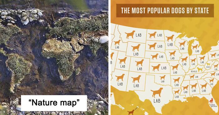
If you’re a visual learner like we are, a good image helps you bring data to life. But if you ever stumbled across a great one, you know it can genuinely change how you see the world. And maps have that power. They are a surprisingly effective tool for understanding the world and giving us a peek into its secrets. By allowing us to explore novel places from the comfort of our own homes, they can even unlock our inner adventurer that’s been deep in winter’s sleep.

Today, we invite you on a journey through this informative corner of Reddit where cartography fans delve into the intriguing treasure trove of territories, statistics, and history. With over 1.9 million devoted members, this online community uncovers some of the freshest and finest maps in a bid to expand our mental horizons.

So let’s appreciate their efforts by scrolling down and devouring ourselves into the newest collection of captivating visualizations. Trust us, they won’t be anything like the ones you saw at school! Be sure to upvote your favorite ones and let us know if you enjoyed learning new things about places you may not have even known about before. For even more informational goodness, check out Bored Panda's earlier posts on this feature right here, here, and here.

#1

Nature Map

Map of the world created with natural materials like moss and stones in a shallow stream, showcasing unusual map art.

Lovesinica Report

RELATED:
    #2

    Map Lovers, I Recently Stopped For 30 Min In A Bookshop Checking Out This Maps Book. Love The Way Visual Information Sticks In Mind!

    Map showing the unusual long shape of Chile compared to the size of European countries, highlighting fascinating world geography.

    AutomaticLibrarian14 Report

    #3

    World Map Cantered On Antarctica

    Unusual and fascinating polar projection map showing Antarctica in the center with surrounding continents reversed.

    axeman_05 Report

    #4

    Countries Which Offer Paid Maternity Leave And The Time They Provide For Expecting Mothers

    World map showing paid leave for new mothers by country, highlighting maternity leave duration in weeks, unusual map data.

    No_Negotiation_7176 Report

    ADVERTISEMENT
    #5

    Every Purple Line Is A Bicycle Lane In The Netherlands

    Map highlighting detailed road networks and cities in the Netherlands, Belgium, and western Germany with unusual and fascinating maps theme.

    wouterk Report

    ADVERTISEMENT
    #6

    In Case You Didn't Know, Holland & The Netherlands Are Not Interchangeable

    Comparison map showing the regions of Holland and the Netherlands highlighted in different colors, unusual maps perspective.

    Initial_Trash Report

    #7

    Difference Between Russia's Unfriendly List Last Year And Now

    World map showing Russia's unfriendly countries in 2021 and 2022 with highlighted nations in red for unusual maps perspective.

    thegirlwithtwoeyes Report

    #8

    Most Popular Dog By US State...

    Map showing the most popular dog breeds by state, featuring labs, beagles, and German shepherds across the USA.

    smooshedeggbog Report

    ADVERTISEMENT
    #9

    The Shape Of The World, According To Ancient Maps

    Timeline of unusual and fascinating world maps from 150 AD to 1832 showing evolving cartography perspective on the world.

    Ayman_alsh Report

    ADVERTISEMENT
    #10

    Percentage Of Population “Absolutely Certain” God Exists In Europe vs. Us

    Map showing percentage of population certain God exists across US states and European countries, highlighting unusual geographic beliefs.

    roi1099 Report

    #11

    Europe Used To Look Like This, Before It United

    Detailed historical map of Central Europe showing old regions and borders, an unusual and fascinating map perspective.

    Over9000Holland Report

    #12

    Russia Density Visualized

    Map showing population density in Russia with uninhabited areas highlighted, illustrating unusual and fascinating maps of the world.

    BrasilemMapas Report

    ADVERTISEMENT
    #13

    The Red Areas Contain Half Of The Total Population Of Australia

    Map showing red areas where half the population of Australia lives, an unusual and fascinating perspective on population distribution.

    padmanabhapillai Report

    ADVERTISEMENT
    #14

    Kid Friendly Curse Words

    Map showing kid friendly cursewords across Europe with colorful country labels and playful translations in different languages.

    atlasova Report

    #15

    North Korean Election Result Of 2019

    Map of North Korea showing 100% support for Democratic Front for the Reunification of the Fatherland with Kim Jong-un photo.

    two_plus_two_is_zero Report

    #16

    The Yuxi Circle: The World’s Most Overpopulated Area

    Globe map showing population density with a 4.32 billion population circle focusing on Asia and Yuxi region.

    madrid987 Report

    ADVERTISEMENT
    #17

    Country’s That Cannot Speak Any Foreign Language

    Map showing percentage of population in Europe aged 25-64 that speaks no foreign language, highlighting language skills by country.

    CraftyAcanthisitta22 Report

    ADVERTISEMENT
    #18

    The Most Popular Browsers In Different Countries In 2012 And 2022

    World map showing the most popular internet browsers by country in 2012 and 2022 for unusual and fascinating maps keyword.

    theworldmaps Report

    #19

    Countries Providing Humanitarian Aid To Ukraine

    World map highlighting countries providing humanitarian aid to Ukraine, showcasing unusual and fascinating global connections.

    KungUnderBerget Report

    #20

    I Made A 3D Model Based On A 1660 Map Of New Amsterdam / New York

    Collage of unusual and fascinating maps with 3D reconstructions showing historical coastal town views and layouts.

    EdNotAHorse Report

    ADVERTISEMENT
    #21

    Is It A Crime To Knock On The Door And Run Away? (Source: UK Legislation Website - Metropolitan Police Act Of 1839)

    Map of Europe showing where it is a crime to knock and run away, highlighting unusual and fascinating legal differences.

    geographyfacts Report

    ADVERTISEMENT
    See Also on Bored Panda
    #22

    Population Density Of Africa!

    Population density map of Africa highlighting major urban areas in bright colors on a dark background, an unusual fascinating map.

    symmy546 Report

    #23

    The State Of Global Democracy In 2022

    Color-coded world map showing democracy scores by country with categories from full democracy to authoritarian regimes.

    cambeiu Report

    #24

    The Usual Time Of Eating Dinner In Europe

    Map showing usual dinner times across Europe with various time ranges highlighted in different shades of blue and black.

    kkaiOkkai Report

    ADVERTISEMENT
    See Also on Bored Panda
    #25

    Traffic Fatalities, Eu vs. Us

    Map showing road deaths per million people in Europe and the United States, highlighting variations in traffic fatality rates by region.

    Repulsive_Narwhal_10 Report

    ADVERTISEMENT
    See Also on Bored Panda
    #26

    Latitude Of World Cities Compared To Europe

    Map highlighting unusual and fascinating global cities, offering a unique perspective on the world through location markers.

    cranberrycactus Report

    #27

    I Love How Africa's Third Longest River Takes Such A Long Route To Get To The Sea From The Source In Southern Guinea

    Map of the N***r River and surrounding West African countries highlighting geographical features and borders in unusual perspective.

    19neo91 Report

    ADVERTISEMENT
    See Also on Bored Panda
    #28

    Europe Mapped By Trees Per Kilometre Squared (Tree Density)

    Map of Europe showing trees per kilometer squared with color-coded density in an unusual and fascinating map perspective.

    JuliusCheesy Report

    #29

    World Map Of Billionaires

    Colorful world map showing data points and statistics for countries, highlighting unusual and fascinating maps perspective.

    PygmalionTheVI Report

    ADVERTISEMENT
    See Also on Bored Panda
    #30

    The Old Borders Of The German Empire Can Still Be Seen In Present-Day Polish Election Results

    Color-coded political map showing voting patterns and party support division across a region, an unusual and fascinating map.

    shruicanewastaken Report

    ADVERTISEMENT
    See Also on Bored Panda
    #31

    If Only 100 People Lived In Eu

    Map showing population distribution if 100 people lived in the EU, using unusual and fascinating map visualization.

    notnonneutral Report

    #32

    Wine Consumption In Europe

    Map of annual per capita wine consumption in Europe highlighting unusual and fascinating patterns by country.

    Landgeist Report

    #33

    Will You Be Offered Food When You Are A Guest

    Map of Europe showing likelihood of receiving food as a guest, an unusual and fascinating map changing perspective on the world.

    barcased Report

    ADVERTISEMENT
    See Also on Bored Panda
    #34

    Coffee Consumption In Europe

    Map showing annual coffee consumption per capita in Europe with varying shades indicating different levels of consumption.

    Landgeist Report

    ADVERTISEMENT
    #35

    What War Is Currently Being Fought Near You?

    World map showing current major wars and conflicts including Russo-Ukrainian war and regional crises.

    atlasova Report

    #36

    Punishment Of Breaking Blasphemy Law Around The World

    World map showing punishment types for breaking blasphemy laws, highlighting unusual and fascinating legal variations globally.

    two_plus_two_is_zero Report

    #37

    Europe's Most Popular Last Names

    Map of Europe showing the most common surnames by country in an unusual and fascinating maps perspective.

    LeolaBosack Report

    ADVERTISEMENT
    #38

    Average Male Height In Europe 2022 (In Cm)

    Map showing average male height in Europe 2022 by country in centimeters, featuring unusual and fascinating maps keyword.

    takibouhnik Report

    ADVERTISEMENT
    #39

    Price Of Full Tank Of Gasoline (60 L) As A Percentage Of Average Monthly Net Salary Across The World

    Map showing the price of a full tank of gasoline as a percentage of average monthly net salary in various countries.

    kiwi2703 Report

    #40

    Where Europeans Lay Claim To Their Neighboring Countries

    Map showing where Europeans claim parts of neighboring countries, highlighting unusual and fascinating maps perspective on the world.

    Upstairs_Yard5646 Report