Get Premium
Dark mode theme is available exclusively for premium users. Learn more about the benefits of subscribing.
No fees, cancel anytime.

 Dark Mode Ad-Free Browsing Unlimited Content
 Ad-Free Browsing Unlimited Content Dark Mode
Join 1.2 million Panda readers who get the best art, memes, and fun stories every week!
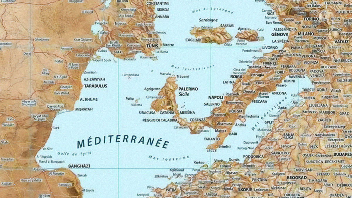
Depending on how old you are, you might remember having to pull out a paper map to find your way around a place. Back then, we didn’t have Siri or GPS. We were forced to put on our thinking caps and navigate the world in a slightly more complex way. Or risk getting completely lost. In today’s digital world, more than a billion people use Google Maps every month, but that doesn’t mean physical maps are a thing of the past.
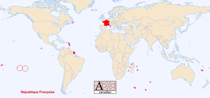
Maps aren’t only used for navigation after all, as this online group proves. It has more than 5.3 million members sharing fascinating maps detailing everything under the sun. From the most overworked countries in the world, to a visual representation of all the lighthouses in France, and even places where cheek-kissing is a common greeting.
We've picked the most intriguing posts from the page, to take you on a journey fit for the most curious of cartophiles. And on the subject of cartophiles, Bored Panda was lucky enough to chat to Ian Wright. He's a map guru and founder of Brilliant Maps, a popular cartography site. You'll find that interview between the images. And as a bonus, we've also included the fascinating story about a fake town that once appeared on a map, suddenly became real, then vanished again.
This post may include affiliate links.
Very cool! Had to click into Reddit to get a higher definition look and it is beautifully done. 👏👏👏
Ian Wright is a little bit obsessed with maps. But not the geographical kind. The cartophile and founder of Brilliant Maps tells Bored Panda he’s been interested more in the political, historical and economic sides of maps for as long as he can remember.
“My adult interest was really rekindled when I decided to walk London's Tube map, above ground of course. I found it was a really unique way to better get to know the city. And I also started looking more into what makes the Tube map unique,” he revealed.
Wright says this sparked an idea to start sharing maps he’d found on Twitter, the former bluebird app now known as “X”. Today, his account has more than 129,000 followers and over 16,000 posts. He’s branched out and built a successful business around his passion for maps.
“I initially started sharing maps on Twitter as a way to learn about the platform. At the start it was just fun sharing cool maps I'd seen,” he said during our interview. Wright tells us that after a few posts went viral, he realized that the platform wasn't the best place to include more data or nuance about the posts.
“So I started the Brilliant Maps website as a place to better explain the maps and put them into a wider context,” he said. And that led to him releasing the Brilliant Maps book in 2019.
Wright says besides the obvious getting us from point A to B, maps are a really useful tool to help quickly explain the world in ways that other forms of visualizations lack. “Unlike charts, graphs, or tables, maps inherently connect data to a place,” he explained. “This allows you to quickly see the difference between places today or the same place over time.”
Wright adds that maps are a great tool for visualizing the world and a great tool for learning about the world. “My kids have both learned about maps at school as a way to better understand the differences between our neighbourhood, city, country and world,” he revealed.
While some believe the digital age might lead to the death of traditional maps, Wright disagrees. “In terms of navigation it's tough to beat Google Maps,” he told us. “However, there's nothing like holding a paper map in your hand. I'm especially fond of historical maps. I recently purchased an original Booth Poverty Map of London and a 16th century map of Brugge, where I lived for a year with my wife.”
Wright says he’s also a big fan of atlases “as you often spot something you never knew you didn't know (unknown unknowns).”
So where does Wright see the future of maps heading? "I think the sort of maps I publish on Brilliant Maps aren't going away anytime soon, although if AI gets a bit better it may be the one making them!" he told Bored Panda.
"In the real world, I think it's likely we'll likely get some sort of Augmented Reality, where you can ask an AI agent about what you're seeing in real time, better optimize your route based on certain criteria, etc."
Reminds me of the pre-colonisation language map of Australia. There were over 150 language groups.
Maps are generally seen as pretty reliable. But you might be surprised to know that cartographers (the people who make maps) sometimes insert fake towns and streets onto them. They aren’t doing this to confuse travelers but rather to catch anyone who tries to forge the map, or infringe on copyright.
The fake places are known as “paper towns” and “trap-streets”. And in a super bizarre turn of events, one of the phantom towns became real for a short while, before swiftly disappearing again.
No one ever did. Chief exports of russia used to be hunger and violence. Then oil and violence. Now it's poverty and violence again.
Load More Replies...And a dragon for Wales. Keeping it real in the UK!
Load More Replies...I did not know France was the C**k. Male chicken if BP censored that.
What I like best about the UK is that one of the animals isn't native to the country, and the other two are fictional.
Scotland should be the haggis, those are honestly very real animals.
Load More Replies...I have always been taught that the danish national animal is the swan, so I question the correctness of this map.
Corsica isn’t a country of its own, so the egg is part of France’s Rooster
Load More Replies...I see lions are fairly popular. Have there ever been naturally roaming lions in Europe?
At least in Greece, as far as I know and then there was a special kind of cave lions, but I think they are extinct for 13000 years or so. I believe the usage of the lion as a heraldic animal is because of legends and the believe it’s the king of all animals. So that’s why kingdoms used them.
Load More Replies...So I called a travel agent to book a trip from Horse to Butterfly and they have no clue what I'm talking about. Shouldn't travel agents know their geography?
It should be illegal to have a national animal which is non-native. Posers? Cilultural appropriation. Also, you should have to change your animal if you hunt it to extinction,
Yup, they have three national animals. Hedgehog, Wood Moose, and Rabbit
Load More Replies...Did not know Polands animal is a lion. And Denmark is a butterfly? Interesting. Why is there an egg and a paw though?
The lion is the Czech Republic. Poland is the white tailed eagle. The egg is because Corsica is a French island, so it goes with the French chicken. The paw is representing a small bit of Turkey, which is represented by a wolf.
Load More Replies...In the 1930s, Otto G. Lindberg and Ernest Alpers from General Drafting Co. were making a road map of New York state. They decided to make up a fictitious hamlet called “Agloe”, and marked it on a dirt road, somewhere between Rockland and Beaverkill. The duo came up with the name by combining letters of their own names. The map was printed and that was that… or not.
As it turns out, a well-known map company called Rand McNally created their own New York state map a few years later. They seemingly fell straight into the trap, placing "Agloe" on the same spot as General Drafting Co. had.
Naturally, when Lindberg got wind of this, he mapped out his revenge and took the matter to court, but his rivals warned that he wouldn't win the case. The defendants claimed that “Agloe” did in fact exist. And they had grounds to prove it.
McNally pointed out that Agloe had a general store, and if Lindberg and his team visited the area, they'd find the shop at the intersection marked on the map. They weren't wrong. Strangely, a shopkeeper had spotted Agloe on a map, and decided to start a business there. This is despite a lack of any surrounding houses or signs of life. Nevertheless, that shop provided enough proof for General Drafting to avoid being sued for copyright infringement.
Did BP really have to censor r a p e? In the context of this map, an explanation of exceptions is necessary.
Agloe's general store didn't last long. We'd hazard a guess it had to do with a lack of demand. But the whole ordeal certainly put the town on the map, so to speak. Author John Green even mentioned it in his novel Paper Towns. "When its protagonist Margo disappears, she leaves oblique clues as to her whereabouts. The trail leads to somewhere and nowhere – Agloe," reported the Guardian.
Some maps still feature the little hamlet of "Agloe." It was even visible on Google Maps, until it was removed in 2014. Despite its non-existence, people flock to visit "Agloe", intrigued by the back story of this mythical "paper town". And maybe today, a general shop would be useful commodity on that deserted dirt road after all.
For now. Gay humans have been around as long as humans have been around.
"Agloe" wouldn't be the only phantom place to appear on Google Maps. In 2009, a place called Argleton attracted camera crews and made headlines. But when reporters visited the "village" near Ormskirk, Lancashire, all they found was... nothing much but a muddy field.
Sorry but my wife is Mexican and we spend a ton of time there. Never have I seen anyone kiss on the cheek
Since humans most likely originated in Africa, everywhere has been 'colonized' by humans migrating out of Africa. The UK has been colonized by Romans, Angles, Saxons, Vikings, etc.
"I grew up in the area and spotted on the map one day that it said 'Argleton'. But it's just a farmer's field close to the village hall and playing fields. I think a footpath goes across the field, but that's all," said Mike Nolan, the man who originally spotted the village on Google Maps. "The name 'Argleton' is similar to 'Aughton'. Maybe someone made a mistake when keying in the name?"
Maybe. Or maybe Argleton, like Agloe, is simply a paper town in a digital world where people love a good mystery.
Is that New Zealand off on its own on the far right? Woohoo - we made it onto the map *and* managed to stay away from all the madness.
A lot of the shading is in the northern states....probably cuz meat rots slower in the fridge. 🤣
I really feel that Spain and Gibraltar could probably just get on with it.
It took Hans Brinker many years of leaving his thumb in that dike to produce what we now see. ;-)
That is only logical given that the Islam in that part of Earth pretty much denies education to girls and women often enforced by massive violence
Haparanda? Is that because of the close proximity to Finland? With border shopping?
Showing again a high correlation, this time between wealth and birth age.
So why don't the rest of us get a "Get out of jail free" card from Christianity?
Today I learned ... that German is (or rather, that German dialects are) no longer the majority language in Lorraine and Alsace, having been displaced by standard French in the last generation or so.
Interesting that Italy increased so little compared to everywhere else.
Like a politician self-identifying as "I am not a crook", self-identifying as democratic can be misleading.
I can't wait until Fox News sees this map. They're going to start calling "Soda" creeping socialism/communism and it's all a plot to make your kids trans. Or something else super weird.
Wait is the tinting of the states opposite to what the tinting of the windows is allowed? Michigan is listed as 0% but is totally black, implying their windows are the darkest.
Wyoming is because they only have 12 people who actually live in the state. ;-)
They're only counting votes, without weighing for population. The U.S. Census says the population is about 340 million. 77 voted for Trump, 75 for Harris (not a huge difference, you'll notice), which shows that neither got even close to half the population...even combined, that's still just a smidgen over 150 million, which is still not half. So saying the entire state leans one way or the other, is a reach, to say the least.
There was a study conducted a few years ago that found that the quality of education at an Ivy League school was not greater than that of other universities and colleges; the only greater benefit was in the connections made as a result.
I live in California. Tesla drivers have replaced BMW drivers as the most obnoxious d-bags on the highways
Add me to that. Animals, a full-time job, and a newborn baby in the house will do that to you.

Polll question re physical maps: I would use one if I could find one.
I have a Melbourne and Country roads directory in my car. I bought them in 2016 when I bought my first car, but they still make them as far as I'm aware. An tourist information centres still have physical maps in Australia, with ads for tourist attractions, wineries etc.
Load More Replies...I love maps! I can spend hours enjoying a detailed map. a detailed map


 No fees, cancel anytime


")
")