Get Premium
Dark mode theme is available exclusively for premium users. Learn more about the benefits of subscribing.
No fees, cancel anytime.

 Dark Mode Ad-Free Browsing Unlimited Content
 Ad-Free Browsing Unlimited Content Dark Mode
Join 1.2 million Panda readers who get the best art, memes, and fun stories every week!
If you're looking for a cool hobby, studying maps might be it. They are like time-traveling storytellers, murmuring stories from hidden corners of countries, the ebb and flow of populations, and the shifting borders across time in history. They're engaging and can easily captivate your attention for hours, much like the 2.6 million members of one special Reddit community.
We invite you to enter a cartographer's dreamland, where lines and colors come together. You might find yourself captivated by the various marks, boundaries, and notes, joining the ranks of map enthusiasts. Give your best-liked maps an upvote and share in the comments the ones that made you want to take up this hobby.
This post may include affiliate links.
This makes me happy! Let's hope it is diverse plantation though, and not monoculture production forest.
Maps capture our attention by blending art, science, history, and exploration into one visual picture that informs and inspires, creating an endlessly captivating and distinct part of human culture and knowledge.
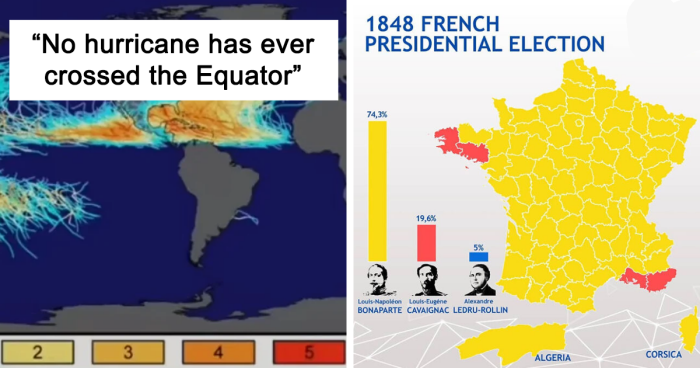
Due to the rotation of the earth and the effects on air and (lesser) water currents, they can't. And most likely the form of the earth is preventing this, too. The earth is not a perfect sphere. If one hurricane does, we are in serious trouble, because the earth axis has tilted. Also interesting: There by far more in number and intensity over the Asian islands than in US. Maybe it is the type of news we get, but the Asian storms seem to have less impact on buildings and people than the US ones?
Yeah, must be the type of news you get. The US ones are more expensive, which just means the stuff they destroyed cost a lot. Like, Katrina caused $125 billion worth of damage, while the 1970 Bangladesh typhoon caused $86.4 million worth of damage. Sounds like Katrina was WAY worse, right? Katrina killed about 1400, as opposed to the 3-500,000 killed in the 1970 typhoon.
Load More Replies...I've seen this map before. What I find so startling is that Ireland has had more hurricanes than the whole of South America!
These tracks include the post-tropical stages of hurricanes and tropical storms. No recorded storm has reached Ireland while retaining its tropical characteristics (same for other very non-tropical places like Kamchatka and Iceland). However, it is theoretically possible that a hurricane has or will hit Ireland; Hurricane Faith in 1966 officially underwent extratropical transition near the Faroe Islands.
Load More Replies...So if you live on the Equator, you are guaranteed safety from hurricanes? I'll lake that!
No. We still get the effects like extreme weather
Load More Replies...Well, duh! Of course no hurricane has ever crossed the Equator. They can´t because hurricanes in the northern an southern hemisphere rotate in opposite directions, so they would basically fall apart because their winds can´t just switch directions
Mate, no need to be condescending when teaching or explaining something new to people. We were all green once. (Don’t ‘duh’ the newbies)
Load More Replies...I guess it's because they spin in opposite directions north and south, there'd be no spin on the equator therefore no hurricane. Only a guess, I stand to be corrected.
Sit to be corrected. Much more comfy
Load More Replies...What’s with the two off the coast of Brazil? I guess they didn’t get the memo that they’re not supposed to be there
I think you may have misunderstood. It isn't that the Southern Hemisphere doesn't get hurricanes, it is that a single hurricane doesn't cross the equator. This is due to the Coriolis force.
Load More Replies...Why not just make the whole planet out of the same stuff as the equator?
Talking of things that haven’t crossed the Equator, Penguins have never crossed it naturally. Too hot for them.
Unfortunately that's not true. Galápagos penguins live on the Galápagos islands, which are located around the equator, apparently it's not too hot for them there (probably because of a cold current in the area). And the penguins that live on the northern tip of the Isabela island, actually live in the Northern hemisphere, so they crossed the equator. They are thought to have come to the Galápagos islands through a cold current, not brought by humans.
Load More Replies...Maps are important because they guide us through the world and offer crucial geographical insights. They act like history books, tracking how places and societies have changed over time, and also work as tools for scientists to study patterns and natural occurrences. Maps help during emergencies, city planning, and protecting the environment. They also support learning, preserving cultures, and connecting people worldwide, even if they speak different languages or come from different places.
Map symbols are crucial as they stand in for real-world objects in a simplified way, making maps meaningful. These symbols can take the form of shapes or colors. For example, a small brown circle might mean a recreational spot, red could indicate services, and green might signal a rest area. Colors, too, play a role in representing larger features: green could mean forests and blue could represent water on a map. To ensure proper map reading, a Map Legend acts as a dictionary, explaining the symbols used on the map and their meanings.
The earliest recorded map is the 'Imago Mundi', also known as the Babylonian Map of the World. Considered the world's oldest surviving map, it currently graces the British Museum in London. Dating back to 700-500 BC and discovered in Iraq's Sippar, this carved relic centers on Babylon, surrounded by areas like Assyria and Elam, all encircled by a "Salt Sea." Eight islands or regions lie beyond this border, etched into the tablet. The map is accompanied by cuneiform text describing Babylonian mythology linked to these regions depicted on the stone.
Something about hitting enormous mountains and then a 4000 m high plateau tends to change the local climate a wee bit
In today's Digital Age, maps are readily accessible—a simple tap on your smartphone and you're on your way to the nearest Starbucks for a quick coffee break. Apps like Google Maps and Citymapper are making things easier, says researcher Mike Duggan from Royal Holloway. He's found that these new technologies are simplifying the complex systems we navigate every day, especially in cities.
Introducing the All New and Improved Zealand (with 15% more zeal!)!
From top left: Canada, UK, Germany, Japan - South Africa, Philippines, [Edit: Australia], New Zealand. I too had my doubts, e.g. Berlin and Munich (in Germany) should be dots, however, these are huge cities in areas of otherwise very low population, so depending how this was calculated, could be still correct.
Having a map in your pocket is a new thing. In the past, people were okay just knowing their local area. As maps got cheaper, they helped make sense of growing cities. Small maps for pockets were a big change.
Now that we've explored why maps are interesting and important, keep scrolling to gain further insights from these captivating maps. And if you're eager for more, be sure to explore our previous editions featuring intriguing maps—found here, here, here, here, and here.
Our local government annoys me about this, beautiful wide road and they started to remove trees claiming they were damaged etc, didn't replace a single one, the houses etc are far away too from them
Nice to the see the UK at the bottom of a positive one for a change! I'd love to see a map like this for the last 5-6 decades and see if all countries have seen a decline and if any have seen an increase.
It is the deadliest natural disaster in British history and may have killed a quarter of the island's population
The "bigbladed" (bigedged) tsunami... *shudders* Pretty clear symbolism that it cut everything it hit down. (Eggen is the sharp side of the blade. Stor means big.)
Even some of the grey marked countries have a wineproduktion - it's just smaller than 2 million hectoliters per year ;-)
Should be listed Busiest _Container_ Ports as they're listed by "twenty-foot equivalent unit" which begs to question, why the heck. By tonnage the list would be: Rotterdam, Antwerp, Hamburg, Amsterdam, Algeciras, Marseille, Valencia, Bergen, Trieste and LeHavre
Need update. Germany just turned off last nuclear plant (bad idea)
Jus soli commonly referred to as birthright citizenship, is the right to acquire nationality or citizenship by being born within the territory of a state.
now put it on top of Tokyo, the size and sprawl of Tokyo and its surrounding metropolitan areas is insanity
This is pretty funny considering the political landscape in the states these days.Those deep blue areas now would probably label FDR a stupid lib communist/socialist/fascist that wants to steal yer freedums
For those who keep rereading the headline unsuccessfully, it reads: "...(New Jersey, Oregon in counties..."
College basketball is very important in Indiana, so it's not surprising it has a big effect on high school basketball.

I love BP articles like this one. Please keep them coming! So much better than re reading about nasty people doing nasty things.
All these maps of Europe. It's like Europeans think the world revolves around them. 🤣 /s
While I was reading these my phone battery was low and I had a side next to me. Guess which one I tried to plug in?
literally barely anything about the usa. Mostly europe. if there was a lot of USA why would it be bad?
Load More Replies...I love BP articles like this one. Please keep them coming! So much better than re reading about nasty people doing nasty things.
All these maps of Europe. It's like Europeans think the world revolves around them. 🤣 /s
While I was reading these my phone battery was low and I had a side next to me. Guess which one I tried to plug in?
literally barely anything about the usa. Mostly europe. if there was a lot of USA why would it be bad?
Load More Replies...


 No fees, cancel anytime


![1529 Map Of The Americas By Diego Ribero [5701 X 7674]](https://www.boredpanda.com/blog/wp-content/uploads/2023/07/64b7804abed28_3qj34ytboaya1__700.jpg "1529 Map Of The Americas By Diego Ribero [5701 X 7674]")


")


")

")


")


")
")


![What The Entire World Would Look Like If All The Ice Melted [6376x4840]](https://www.boredpanda.com/blog/wp-content/uploads/2023/07/64b7816af402a_RRZIm9u__700.jpg "What The Entire World Would Look Like If All The Ice Melted [6376x4840]")


?")


![This Is What Chatgpt Considers The Most Notable Thing About Each Country In Europe [oc]](https://www.boredpanda.com/blog/wp-content/uploads/2023/04/644a15447c391_fgyk97zuweva1-png__700.jpg "This Is What Chatgpt Considers The Most Notable Thing About Each Country In Europe [oc]")


")


")
")