Get Premium
Dark mode theme is available exclusively for premium users. Learn more about the benefits of subscribing.
No fees, cancel anytime.

 Dark Mode Ad-Free Browsing Unlimited Content
 Ad-Free Browsing Unlimited Content Dark Mode
Join 1.2 million Panda readers who get the best art, memes, and fun stories every week!
A good map is worth a thousand words. A bad one, on the other hand, is just one, and usually a pretty ugly one.
If you've been on Bored Panda long enough, you probably know that we have a soft spot for cartography. After all, we've already covered it here, here, and here.
So when we discovered the social media project 'A Map A Day', we knew we had to make a publication about it too. Run by a cultural geography and tourism student, it regularly shares all sorts of geographical oddities that challenge the way you see the world.
Continue scrolling and see for yourself!
More info: Instagram | Facebook
This post may include affiliate links.
The map reads left to right, "you can make these maps say whatever you want by adjusting the methodology, half the time your just amplifying random noise because the underlying data doesn't vary that much from one state to another. But whatever no body checks this stuff. just pick whatever normalization let's you make fun of Florida." lol
The evolution of maps has taken a long road. We, humans, have documented our surroundings for thousands of years, in the form of cave paintings, stone tablets, religious maps, printed maps, and the multi-layered digital maps of modern day.
From ancient Babylon, through the Renaissance, and into the present, mapping history offers a fascinating look into the collective psyche of each period.
This so so true and some are so sad. The ones with the parents and dogs really make my heart ache.
Never finding the end on that tape now! Was hard enough already
The Imago Mundi (more commonly known as the Babylonian Map of the World) is considered the oldest surviving world map.
It is currently on display at the British Museum in London and dates back to between 700 and 500 BC. It was found in a town called Sippar in Iraq. The carved map depicts Babylon in the center with places like Assyria and Elam nearby, all surrounded by a “Salt Sea” forming a ring around the cities.
Outside the ring, eight islands or regions are carved into the tablet. The map is accompanied by a cuneiform text describing Babylonian mythology in the regions depicted on the stone.
This is heartbreaking! I watched a documentary during Shark Week and it stated that most of the sharks killed are just for their fins. The fins are made into Shark Fin soup. I hope we can make it illegal world wide to kill sharks. The are beautiful and amazing creatures.
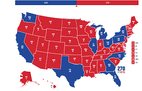
If only the supreme court had ruled gerrymandering unconstitutional.... But the electoral college pretty much guarantees that the supreme court will have more conservative than liberal judges. A republican presidential candidate hasn't won the popular vote since 2004 yet they have appointed 5 of the 7 judges since then.
And the candidate that won in 2004 got into office in 2000 after losing the popular vote. He got a bunch of folks whipped up into a fury after 2001 and got us into an unjust forever war that got him re-elected in 2004. There's a reason McConnell's number one priority has been packing the courts and obstructing any nominees to federal courts or the supreme when a dem is in office. There's a reason that the party has prioritized winning state legislative races, so they can redistrict and restrict voting access. They know that they don't have the majority of the voters. They can't win a fair fight.
Load More Replies...all that bulls*it over made up illegal votes and this right here NEVER gets much attention.
I'm all in favor of that for the presidency, however the districting issue here in the US has to do with determining what area a congressional representative covers. The Senate is statewide, so strictly popular vote. But each member of the House of Representatives represents a geographical region of a state.
Load More Replies...Seams as if someone can change districts w***y nilly to suit their needs.
Load More Replies...This is why proportional voting is much better, and STV is the best of all!
"First past the post voting" is never a solid democracy. Cheaters gonna cheat.
I learned about this earlier this year in geography! Gerrymandering! We had to even do it ourselves. It feels pretty unfair the way a lot of people do it, but there's not really much we can do.
Eight states in the US use independent redistricting committees. Maybe there's a movement in your state to do the same. It's worth fighting for. In my state, we have a process for citizens to put propositions on the ballot. That's how we changed from the legislature drawing the lines to an independent citizen's commission.
Load More Replies...Wish we could just use the closest voting location to the voters residence. Only changing it if the population gets too high to open up a second location and so on. This whole redistricting thing is so dumb. Nothing like the losing team remaking the rules so they can have a possibility of winning.
Redistricting *is* changed only in response to population changes. That’s why it coincides with the census. The trouble comes when partisans get to decide how to group like population numbers into districts.
Load More Replies...Redistricting is called redistribution in Australia. If any party attempted to manipulate the process and corrupt it to favour their electoral chances it would be scandalous, probably cause the party to lose the next election, and lead to criminal trials. It is possible to have independence in this process, it just takes will.
These charts mean nothing without seeing the physical layouts of the districts.
The court just blocked the Democrats in NY for exactly this https://www.cnn.com/2022/04/27/politics/new-york-court-blocks-map/index.html
The Wisconsin GOP gerrymandered and STILL lost the governor election. Then the decided that after all these years of a Repub governor, that governor have too much power. Politics at its finest.
and yet, no politicians think "maybe i should just do a better job"
Gerrymandering is so fascinating!!!! I remember learning about it in AP Human Geography. Interesting stuff.
Y'know... with computers, it should be pretty simple to generate a districting map consisting of areas of _X_ population with the smallest borders - thus completely ignoring anything OTHER than pure population density. Probably a silly idea...
Thats just too simple for US politicians. Got to make it more complex so its easier to do shady s**t without people noticing
Load More Replies...Here in Canada it is entirely based on the census done every 10 years. It has nothing to do with political parties whatsoever. It is not drawn up province by province. It is drawn up by, yes, an independent board and based on populations in different areas. Our "riding" hasn't changed in decades because the population hasn't changed enough in decades that would warrant it. It's still square.
Unless the bureaucrats counting the votes belong to a Government employee's union, then Blue wins regardless of the districting scheme.
So they just let some republicans win to keep people in the dark? You really think if Dems could cheat like this Mitch Mcconnell would still be in office?
Load More Replies...The medieval maps, on the other hand, seem to have been dominated by the church, reflecting the ecclesiastical dogmas and interpretations of Scripture
But during the late Middle Ages, a great deal of enthusiasm was generated by the travels of Marco Polo in the 1270s and 1280s.
New information about faraway places, and the stimulation of interest in world maps, promoted their sale and circulation and it was evident that Marco Polo’s experiences inspired the desire for exploration in many.
And take the blue away and you have Denmark - What country was they under to 1814!
Progress in other areas such as navigation, ship design and construction, instruments for observation and astronomy, and general use of the compass helped to improve existing map information, as well as to encourage further exploration.
Eventually, geographic knowledge was profoundly increased during the 15th and 16th centuries as Columbus, da Gama, Vespucci, Cabot, Magellan, and others made their discoveries, gradually transforming the world maps of those days.
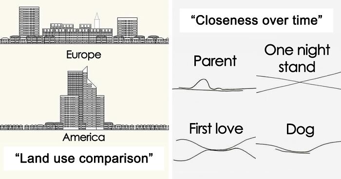
we might have apartments instead of houses in Europe, but also we can walk pretty much anywhere, totally worth it!
Arguably the most important aspect of postmedieval maps was their increasing accuracy. It was made possible by continuing exploration.
Another significant characteristic was a trend toward artistic and colorful rendition, for the maps still had many open areas in which their creators could indulge their imagination. Interestingly, many maps of this age have become sought out collectors' items.
Why are humans so ENDLESSLY destructive?! It makes me despair. So many things those of us alive right now have never seen and never will see - trees this size; huge flocks of birds; rivers silver with fish; endless waves of buffalo and bison on the prairies; truly clean air... all those things, and so much more, once existed. All gone now.
A reformation of cartography that evolved during the 18th century, however, popularized scientific trends and more accurate detail, thus replacing all the monsters, lions, and swash lines with factual content.
Soon the only decorative features were in the cartouche and around the borders. The map interiors contained all the increasing information available, often with explanatory notes and attempts to show the respective reliabilities of some portions.
If earlier mapmakers chased quick, profitable output based on information obtained from reports of travelers and explorers, the new French cartographers were scientists, often men of rank and independent means.
For expensive ventures, such as the triangulation of two degrees of a meridian to determine the Earth’s size more accurately, they were even subsidized by the king or the French Academy. Similar trends were emerging across all over Europe.
This shows how foolish those maps are that purport to show high Republican support across the country. Land doesn't vote, people do. But you take a sparsely populated state and color the whole thing red and it looks like this. PEOPLE need representation, not stretches of soil between arbitrary borders.
During the past few decades, there has been a growing interest in the automation of mapping processes, and considerable progress was made in this area.
But as we can see from the pictures, there's still plenty of creativity going into making maps.
I guess "Florida Man" is too scary to be included in this map.
If the USA was a game map? Where’s the boss fight and the loot locations?
This is just sad. And yet at the same time, the reservation is preserving the land.
It always amazes me how many people are in Bangladesh considering how small of a country it is.
Ok so this is a grid of sorts but I guarantee you that I would get majorly lost here! There are too many options.
Ah, yes not landlocked, landlocked, doubly landlocked and 𝙉𝙀𝘽𝙍𝘼𝙎𝙆𝘼
I hope one day I can either rent or buy an RV and travel this path. I have been to all of the east coast and all of the southern states but not a lot of the ones in the middle and the north. I think it would be a lot of fun! Who's with me?
This us awesome. I once walked one of the routes above ground as best as I could for fun, back in the day.
This breaks my heart too. I know that there are a few reasons to why this is happening. I just wish there was something we could do to increase the numbers. These lions are such majestic creatures
Vermont Street, also in San Francisco, is actually more crooked. Lombard is just more famous.
So part of Montana, Wyoming, Colorado and New Mexico would be mostly land? Interesting!
Some (a lot) are missing. In turkey, africa, and other countries
Brokeback mountain is incorrect. It was filmed just outside of Calgary, Alberta, Canada. Nobody in Wyoming would recognize anything as being Wyoming, cause it isn't.
There's only one black state. They are not going anywhere. The odd one takes a vacation overseas.
Im totally lost lol. So many Mexicans in the US and so many Americans in Mexico. What am i supposed to be looking at? I am legit asking, im confused af lol
I want to see the world divided so that every country has the same population - and that could be used for international competitions. Maybe also a map that allocates the same wealth to each country, for alternate years at those competitions, just to make it more fair.
Some of these are quite interesting, some I just got lost more than anything, and most are beautiful in colors. A few were hilarious.
What is Agony Island????? It's been on the header image all day but isn't on the list!!
This list actually made me realize how much I've learned in geography this year for some reason


 No fees, cancel anytime


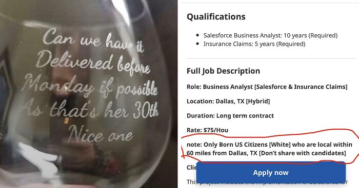
, Carved Onto A Roll Of Tape")
")


")


")


")
")


")