ADVERTISEMENT
Article created by: Ilona Baliūnaitė

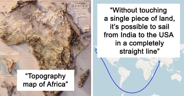
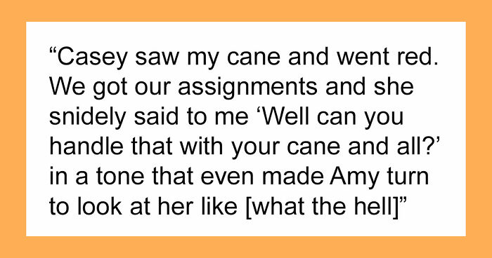
Maps can look absolutely incredible, but they require a lot of focus and dedicated effort. Whether you’re an artist, adventurer, geographer, engineer, statistician, or just a fan of good design, quality cartography can bring you a whole lot of joy.
The ‘Epic Maps’ account on X (formerly Twitter) is a fabulous project that celebrates great examples of cartography. Many of these designs are unique, creative, and unusual, so we wanted to share the very best ones with you, dear Pandas. Scroll down for a look, and don’t forget to upvote your favorite ones!
More info: X | Instagram | YouTube | Newsletter

#1

Topography map of Africa showing detailed terrain features in a collection of maps beyond just country locations.

Locati0ns Report

RELATED:
    #2

    South America elevation map showing detailed terrain and mountain height variations in a 3D topographic style.

    Locati0ns Report

    #3

    Map showing global distribution of penguins highlighted in blue, illustrating unique geographic data beyond country locations.

    Locati0ns Report

    #4

    Map showing the true size of South America compared with multiple countries in an informative comparison map set.

    Locati0ns Report

    ADVERTISEMENT
    #5

    Night lights map of Korea illustrating population density and urban areas in a detailed epic map visualization.

    Locati0ns Report

    ADVERTISEMENT
    #6

    Map showing major roads across Europe converging toward Rome, illustrating unique map perspectives beyond country locations.

    Locati0ns Report

    #7

    Map showing evidence of Pangaea through similar fossil remains across continents, highlighting connections beyond location.

    Locati0ns Report

    #8

    Color-coded map showing U.S. annual mean lightning strike density from 2017 to 2023 with varying intensity levels

    Locati0ns Report

    ADVERTISEMENT
    #9

    Map showing red areas representing half the population of Australia, illustrating population distribution on detailed epic maps.

    Locati0ns Report

    ADVERTISEMENT
    #10

    Map showing the longest possible train travel route in the world highlighting extensive geography across multiple countries.

    Locati0ns Report

    #11

    Map showing the Mediterranean Sea overlaid onto the USA, highlighting unique geographic comparisons in epic maps collection.

    Locati0ns Report

    #12

    Map showing Germany's economy size compared to highlighted European countries with GDP values for SEO maps keyword.

    Locati0ns Report

    ADVERTISEMENT
    #13

    Map showing uninhabited green areas of New Zealand, highlighting unique geographical data beyond just country location.

    Locati0ns Report

    ADVERTISEMENT
    #14

    Map showing the real size of Africa compared to countries like the United States, China, India, and Europe for location insights.

    Locati0ns Report

    #15

    Map showing a unique sailing route from India to the USA without touching land, illustrating creative map usage.

    Locati0ns Report

    Paul Sloan
    Community Member
    8 months ago Created by potrace 1.15, written by Peter Selinger 2001-2017

    That line is about as straight as John Travolta.

    #16

    Population density map of Egypt showing concentrations around Nile River using color gradient in detailed epic maps.

    Locati0ns Report

    ADVERTISEMENT
    See Also on Bored Panda
    #17

    Map showing countries with a smaller population than Java, highlighting global population distribution for SEO maps keyword.

    Locati0ns Report

    ADVERTISEMENT
    See Also on Bored Panda
    #18

    Map showing the different names for hamburger by US county, highlighting regional language variations and cultural differences.

    Locati0ns Report

    #19

    Map showing population density in China with 94% living in eastern regions illustrating detailed data beyond location.

    Locati0ns Report

    ADVERTISEMENT
    See Also on Bored Panda
    #20

    Color-coded map of Antarctica's multiple time zones illustrating the continent’s unique geographical divisions on a thematic map.

    Locati0ns Report

    #21

    Map showing locations of bombs dropped by the USA on Laos illustrating nine years of intense bombing activity.

    Locati0ns Report

    ADVERTISEMENT
    See Also on Bored Panda
    #22

    Map showing the number of domestic cats per 1000 people across European countries with key data insights.

    Locati0ns Report

    ADVERTISEMENT
    See Also on Bored Panda
    #23

    Map showing European countries with more men or women, highlighting gender distribution across the continent using color-coded regions.

    Locati0ns Report

    #24

    Map of America before 1846-1848 Mexican American War showing historical borders on an informative map for SEO maps keyword.

    Locati0ns Report

    #25

    Map showing dense distribution of churches across Poland, illustrating detailed geographic data beyond just location.

    Locati0ns Report

    ADVERTISEMENT
    See Also on Bored Panda
    #26

    Map showing the Ivy League universities in the USA with location markers in a regional Northeast map for SEO maps keyword.

    Locati0ns Report

    ADVERTISEMENT
    See Also on Bored Panda
    #27

    USSR electrification map from 1959 showing electrical grid connections across the country as part of epic maps collection

    Locati0ns Report

    #28

    World map highlighting countries that use bidets, showing geographical distribution as a unique map insight.

    Locati0ns Report

    #29

    Map of Europe highlighting famous regional dishes, illustrating diverse food culture beyond just country locations.

    Locati0ns Report

    ADVERTISEMENT
    ADVERTISEMENT