Get Premium
Dark mode theme is available exclusively for premium users. Learn more about the benefits of subscribing.
No fees, cancel anytime.

 Dark Mode Ad-Free Browsing Unlimited Content
 Ad-Free Browsing Unlimited Content Dark Mode
Join 1.2 million Panda readers who get the best art, memes, and fun stories every week!
I am an unreachable traveler and a fanatic of history, arts and supernatural things.
These are some strange, peculiar or curious maps of the world. I collected and chose them because I consider them worthy of admiration for their concepts or their aesthetics.
Look the maps up on the web for a more detailed view!
This post may include affiliate links.
This map by Czech cartoonist Jaro Hess shows all the rhymes, children's stories and popular songs in a fictional space. It is possible to find Little Red Riding Hood, Humpty Dumpty and the plant that grew to heaven from Johnny and the beans.
My name is Mario Yaír T.S. and I love spreading culture. I wrote the guide "Insolita y Secreta Ciudad de México" (Secret Mexico City) published by Thomas Jonglez, the founder and editor of the French company Jonglez, and I used to contribute to Time Out Mexico, Warp, and Atlas Obscura.
This map is considered a historical curiosity, not only for being the largest in the known medieval world, but for being the work of the female hands of the Ebstorf convent. It shows Christ as the world and in the center the mythical earthly paradise surrounded by a wall of fire.
Beautiful map but I believe it has Jerusalem at the centre as many maps of the time had. Unfortunately the original was destroyed in a bombing raid during WW2.
Published in 1877 after the Russian Empire attacked the Ottoman Empire, the British Frederick W. Rose decided to represent Europe in this way.
In 2012, I was studying Audiovisual Communication at Claustro de Sor Juana. But school didn't excite me, and I wasn't spending my afternoons buried in homework. Instead, I found myself wandering the streets of the Historic Center in Mexico City, exploring without any particular goal.
One rainy day, I took shelter in the Gandhi bookstore near Palacio de Bellas Artes. I found a guide to unique places in London. Reading it, I felt Mexico City had even more interesting spots. So, I contacted Thomas Jonglez, suggesting writing a guide for the city. And after 5 years, "Secret Mexico City" was released.
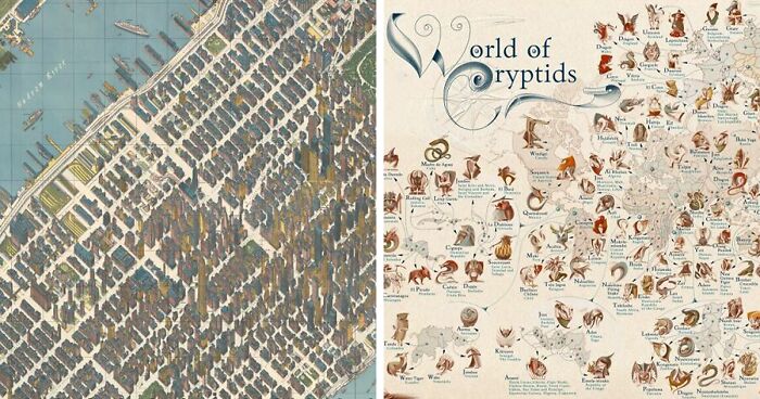
Illustrated by Laimutė Varkalaitė, the map of the world's cryptids shows the most famous or relevant cryptozoological being in each country. Its publication was included with a map of each continent and an illustration of home.
This map was created by William Gropper to illustrate American legends, myths, and folk tales. There it is possible to see everything from the Salem witches to the Mormon myth of the sacred writings found in Utah.
I am a fan of culture and supernatural things and this collection of maps is a testament to that passion. In fact, a few years ago, I even created a map myself. While stuck at home during quarantine, I thought it would be fun to put miniature monsters on my door, like the ones from medieval times. As I worked on it, it turned into a medieval map with many symbols, hidden surprises, and many different references.
The monsters on my door weren't just from Europe; they came from other places around the world too. So, it took me a long time to finish the map—I wanted to include creatures from many different cultures.
If you're interested, you can check the map on Bored Panda.
Map of Mexico City in 1932 designed by Emily Edwards where the city is represented as an Aztec eagle warrior.
Inspired by a sculpture of Peter Pan, this map was designed in 1923 to decorate public transport in London in order to entertain passengers waiting for the train. It is a mixture of reality and fiction of actions that fantastic characters carried out in the surroundings.
In 2014, the artist Sohei Nishino made a series of large-format maps of different cities around the world, using photographs. The Tokyo map has nearly 10,000 different images of the city that show its spaces, its people, its buildings and even its advertisements.
This world map made by Antonino de Saliba in 1600 shows in a series of rings the ethereal kingdom of demons (phoenixes and salamanders), the celestial vault, climatic phenomena, crops, the known world, the earth, rivers and volcanoes, to finally end in the center with hell.
Looks like the map they used in one of the Pirates of the Caribbean movies.
Created by Frank Dorn, this tourist map shows not only the inside and outside of the Forbidden City, but illustrations of the city's history both inside and on the frame.
Map with pictograms of the Santiago de Chile metro lines, published the year of its inauguration in 1975.
Created as a tourist information map for the 1964 World's Fair, this map designed by Hermann Bollmann shows the city's skyscrapers in detail in 1963.
It's worthwhile looking these up on the web to see the details on larger versions.
I second that - super high resolution images needed!
Load More Replies...OK, vote on the most iconic fiction maps of all time: Sodor (Thomas and the Railway Series), Middle Earth (Lord of the Rings) or Narnia (Chronicles of Narnia). Open to other suggestions.
Love the idea of getting maps as a puzzle. That might be a rabbit hole I fall down into this afternoon.


 No fees, cancel anytime

")

")
")
")
")
")
")
")
")

")
")
")