ADVERTISEMENT
Article created by: Austėja Akavickaitė

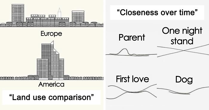
A good map is worth a thousand words. A bad one, on the other hand, is just one, and usually a pretty ugly one.

If you've been on Bored Panda long enough, you probably know that we have a soft spot for cartography. After all, we've already covered it here, here, and here.

So when we discovered the social media project 'A Map A Day', we knew we had to make a publication about it too. Run by a cultural geography and tourism student, it regularly shares all sorts of geographical oddities that challenge the way you see the world.

Continue scrolling and see for yourself!

More info: Instagram | Facebook

#1

Visual Guide To Geographic Terms

Colorful illustrated map showing various geography terms like mountain, desert, glacier, peninsula, island, and archipelago.

amapaday Report

RELATED:
    #2

    Most-Used Word In Each State

    Map of the United States showing the most-used word in each state based on search data, featured in interesting maps collection.

    amapaday Report

    Chris Shaw
    Community Member
    7 months ago Created by potrace 1.15, written by Peter Selinger 2001-2017

    Very funny - read across the map following the colours

    #3

    Victoria Peak (Hong Kong), Carved Onto A Roll Of Tape

    Roll of electrical tape with intricate 3D cityscape model on its surface, showcasing creative interesting maps design.

    amapaday Report

    #4

    Sharks vs. Humans (2014)

    World map showing sharks k****d by humans versus humans k****d by sharks in 2014 with comparative data visualization.

    amapaday Report

    ADVERTISEMENT
    #5

    Clouds Flow Past Mt. Fuji, Japan

    Aerial view of a mountain peak piercing through clouds, seen from an airplane window, showcasing an interesting map perspective.

    amapaday Report

    ADVERTISEMENT
    #6

    A Chart Illustrating Gerrymandering In Its Most Basic Form

    Diagram showing election districts and precincts with red and blue votes illustrating how maps can change election outcomes.

    amapaday Report

    #7

    The Many Flags Inside Norway’s Flag

    Norway flag with labeled boxes comparing its size to Indonesia, Poland, Finland, France, Netherlands, and Thailand on an interesting map.

    amapaday Report

    #8

    Day And Night In Barcelona

    Aerial view of a city split between daytime and nighttime, showcasing interesting maps that might change perspective.

    amapaday Report

    ADVERTISEMENT
    #9

    Wind Blown Patches Of Snow Cause A 3D Effect In Eastern Colorado

    Aerial view of vast farmland with geometric fields creating a patchwork pattern, illustrating interesting maps perspectives.

    amapaday Report

    ADVERTISEMENT
    #10

    A Bar In Dc Made A Us Map From One Summer's Confiscated Fake Id's

    Map shaped from hundreds of ID cards arranged to create an interesting map perspective shared on Instagram.

    amapaday Report

    #11

    Land Use Comparison Of A Typical European City And A North American City

    Comparison map showing land use differences between a typical European city and a North American city, highlighting urban layout.

    amapaday Report

    #12

    Detailed Replica Of Manhattan Carved Out In A 2.5 Tonne Block Of Marble

    3D printed topographic map sculpture showcasing detailed terrain and elevation changes, an interesting map perspective artwork.

    amapaday Report

    ADVERTISEMENT
    #13

    How The Solar System Travels Through The Galaxy

    Complex planetary orbits displayed in an interesting map showing gravitational paths and interactions in a solar system model.

    amapaday Report

    ADVERTISEMENT
    #14

    When Two City Planners Hate Each Other (Missoula, Montana)

    A satellite map showing contrasting city planning styles illustrating interesting maps that might change your perspective.

    amapaday Report

    #15

    A Guide To Chicago Home Styles

    Various architectural home styles illustrated in a detailed map of housing types, featured on an Instagram account with interesting maps.

    amapaday Report

    #16

    Aerial View Of The Planned City Of La Plata, Argentina

    A detailed aerial map showing urban grid layout with diagonal streets and green spaces in a cityscape.

    amapaday Report

    ADVERTISEMENT
    See Also on Bored Panda
    #17

    The Timeline Of A Tree

    Cross-section of a tree trunk with historical events marked, featured in interesting maps that might change your perspective.

    amapaday Report

    ADVERTISEMENT
    See Also on Bored Panda
    #18

    Using The Statue Of Liberty To ‘Map’ How Copper Goes Through The Oxidation Process

    Statue of Liberty color changes over time in an interesting map illustration showing oxidation process from unexposed to 25-30 years.

    amapaday Report

    #19

    Global Distribution Of Penguins

    Map showing global distribution of penguins highlighted in blue across southern hemisphere regions.

    amapaday Report

    ADVERTISEMENT
    See Also on Bored Panda
    #20

    The Arc De Triomphe At The Center Of 12 Radiating Avenues In Paris, France

    Aerial view of an intricate urban layout showing a detailed city map highlighting unique street patterns and structures.

    amapaday Report

    #21

    Eight Minimalist Maps

    Minimalist maps showing airports, railroads, roads, rivers, land borders, lakes, cities, and seaports worldwide for map perspective.

    amapaday Report

    ADVERTISEMENT
    See Also on Bored Panda
    #22

    States With A Smaller Population Than Los Angeles County

    Map showing US states with smaller populations than Los Angeles County highlighted in blue, featuring interesting maps perspective.

    amapaday Report

    ADVERTISEMENT
    See Also on Bored Panda
    #23

    How To Read Tree Rings. The Color And Width Of Tree Rings Can Provide Snapshots Of Past Climate Conditions

    Cross-section of a tree trunk showing growth rings and seasonal changes in an interesting map style diagram.

    amapaday Report

    #24

    Train Cars Filled With Coal On Lambert's Point Pier 6 In Norfolk, Virginia

    Aerial view of extensive railway tracks and trains forming an interesting map pattern changing perspective.

    amapaday Report

    #25

    ‘Nobody Lives Here’, 1x1km Areas In The United Kingdom Where The Reported Population Equals Zero

    Map showing areas with zero population across the UK in yellow, visualizing 1x1 km blocks with no residents.

    amapaday Report

    ADVERTISEMENT
    See Also on Bored Panda
    #26

    Everyone In The World Could Fit Into A 50km Diameter Circle

    Crowded people shown packed within a small circle on a world map, illustrating population density on an interesting map.

    amapaday Report

    ADVERTISEMENT
    See Also on Bored Panda
    #27

    The North American Cryptid Map

    Map of North American cryptids including Sasquatch, Mothman, Chupacabra, and Wendigo with illustrated creatures by state.

    amapaday Report

    ADVERTISEMENT