30 Unusual Maps People Shared On This Group That Might Change Your Perspective On Things
Interview With AuthorFor many of us, cartography day in geography or history class meant a quick nap. With our eyes open, we’d dream of all the delicious stuff we were gonna eat after school, of music we’d play on the Walkman, of a message we received the other day from that cutie…
To bring back our long-lost excitement for hard pieces of data, aka maps, plans, and geographic drawings, we're gonna need to start from the very best of them. Luckily, there’s a whole online community on Reddit dedicated to the most unusual charts of geographic areas that took maps to a whole new level.
From mapping "October" in European languages to mapping an eagle’s track over a period of twenty years, these incredible examples will surely put the world into a completely new perspective.
Who knows, you may well unleash your inner cartographer and become among 1.1 million like-minded members of the maps subreddit. In that case, you may need some more cartographical goodness with 41 maps that portray lesser-known facts about America.
This post may include affiliate links.
An Image Of GPS Tracking Of Multiple Wolves In Six Different Packs Around Voyageurs National Park Shows How Much The Wolf Packs Avoid Each Other's Range


To Increase Local Tourism, Lithuania Has Made A Map With Magnets That You Can Only Find In Corresponding Cities

Occupied Bald Eagle Nests In Wisconsin. 1974 vs. 2019. Growth Credited To The Clean Water Act

To find out more about this amusing Reddit community by the name r/MapP**n, Bored Panda reached out to its creator Patrick McGranaghan, who started the subreddit in 2011 while living in Taiwan.
Patrick said he has always been a map geek: “I wanted people to share those maps so that they are easy to find and discuss.”
It turns out, he works as a land surveyor in Colorado and is a devoted member of several map societies across the nation, including the North American Cartographic Information Society, Charles Close Society for the Study of Ordnance Survey Maps, and Rocky Mountain Map Society, to name just a few.
Tracking Of An Eagle Over A 20 Year Period

When A Band Announces A World Tour

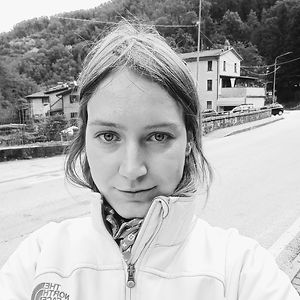
Japan, How Big It Is In Reality?

Okay, mind blown; it's literally twice as big as I'd imagined given typical maps. Thank you, person who made it!
The creator said that the title r/MapP**n followed the trend on Reddit at the time when “there were a lot of subreddits with a *-porn suffix.” He explained further: “This refers to pictures of innocuous things like nature, architecture, or engineering marvels in a beautiful way. It was not meant to be sexual. The internet at the time was a lot more relaxed and using that term was funny.”
“In the years since the culture on the internet has taken a much more puritan bias and some people don't like that name,” Patrick said.
However, he assured us that “the goal of the brand has not changed, though: it's a place to share and discuss beautiful maps.”
The Earth Being Centered On Great Britain Is Arbitrary, So Here's A Map Centered On New Zealand

Cheese Map Of Europe

The United States Of America: Alaskan Perspective

When it comes to submissions, they come in every form and style. “From historical maps showing ancient borders, to funny memes and transit maps. People also post imaginary maps of places that they create in their minds.”
In fact, every kind of map imaginable has been posted to this subreddit. Patrick said that linguistic maps are popular, as well as maps that re-imagine state and national borders. There are also maps of asteroids and maps of routes of famous explorers.
“One of my favorite interactions is when a map is posted of an obscure place and someone in the comments says they live there or has a story about that place.”
50 Percent Of Canadians Live South Of The Red Line

Each Section Has 10% Of The World's Population

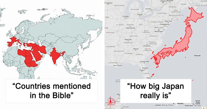
List Of Countries Mentioned Or Referred In The Bible

Wow, I never knew this. Unlikely Jesus was fair skinned, blond and blue eyed....
Patrick concluded that “Maps are a way to visualize the world in a way that is easy to grasp. They are an aid in learning about new lands and faraway places. They help us find our way when we are lost.”
Especially in a time like now, “when the pandemic prevents us from traveling, maps are a way that we can travel without leaving our home,” the map enthusiast said.
The Longest Possible Train Travel In The World

Where Penguins Are Found Naturally In The World

Size Comparison Between Australia And The United States

3D Render Topographic Map Of Europe

I didn't know there was an ice-wall between Finland and Russia!?! (Do I need to write 'Sarkasm'?)
North America Animal Migration Routes

A Europe–U.S. Superhighway Proposed By The Former President Of Russian Railways

The Surface Of Mars: If, Like Earth, 71% Of Its Surface Area Was Covered With Water

World's Smallest Country vs. Largest Building

The Decline Of Our Native Tongue Over The Last 2 Centuries, I Find The Maps Rather Than The Reciting Of Statistics, Gives A Far Better Impression On The Overall Erosion Of One Of The Biggest Aspects Of Our Culture, Irish Itself

Worlds CO Emissions

are you surprised that China are the biggest problem in pollution? and they don't give a sh!t
They keep signing and breaking the multinational agreements and no one holds them accountable.
Load More Replies...The map is kind of deceptive though. If it was at the top you'd have lots of people saying stuff like, "See, China creates most of the world's global warming!!! We shouldn't have to make any changes!!!" Well... outsourcing your manufacturing doesn't absolve you of the responsibility for it. Also, CO is carbon monoxide. Is this carbon monoxide or carbon dioxide?
Load More Replies...This seems to be taken from windy.com. First this map is not CO but CO2. Secondly it's not emissions but concentration. Thirdly when it's night in the US it's day in China and something in between in Europe, so time of day makes a big difference. For example this map shows Europe has much bigger emissions than the US when in fact it's the other way around.
I was thinking the same thing! I know America has way more pollution that this. We have plenty of factories too. We have extensive highway systems with low public transportation. Heck! Houston and Beaumont have the largest oil refineries but you don't see anything over them.
Load More Replies...https://www.windy.com/-CO-concentration-cosc?cosc,2020-10-21 this is the source as of 20th October 2020. CO concentration is very seasonal especially in agricultural countries and those prone to forest fires. Please don't sleep happy at night celebrating the USA leaving the Paris Accord - USA is still 2nd biggest producer of CO2 the leading contributor to climate change. http://www.globalcarbonatlas.org/en/CO2-emissions
I would love to see this map pre-covid and during. I kept reading about how our being quarantined cleaned things up!
If it really means CO- there's a bigger problem than we thought!
Almost everything at stores in other countries is made in China, that's like saying don't buy ANYTHING.
Load More Replies...This map doesn't seem to make sense. The U.S. produces 25% of the global CO2.
We need to stop using breakable useless plastic crap , that goes straigh to garbage. Upcycle or build lasting things and collect alle plastics. We can bring this down and be happier too.
The map is from windy.com. It shows concentrations, not emissions. CO2 emitted from land blows over the oceans. On windy.com the map is animated so you can clearly see the wind carrying the air from the hotspots.
Load More Replies...you will probably look at this and think "oh that`s bad what`s the next fun map" but this should make you truly angry.
CO2 (edited, oops) emissions did reduce this year, but not by nearly enough to make any real difference. Also it was only temporary.
Load More Replies...how can South America produce more than the U.S.? totally did not expect this
It's not a typo - they mean CO not CO2. Angola = crop management fires, Brazil = forest fires. So don't go losing sleep USA is still 2nd largest producer of CO2 by country
Is this really accurate? With fossil fuels still being in use in the US, and consumption rates off the roof, how is it possible that their carbon footprint is so low? Sounds like another US propaganda map to me.
Scrubbers. Example, coal plant in Columbia Wisconsin just spent $1 billion to make the emissions cleaner.
Load More Replies...No offense i am not saying you are personally to blame for this complex problem. Just saying it's probably everybody's.
Load More Replies...I’m truly shocked that Texas isn’t darker. I drove through Houston one time and could barely see the road ahead of me. And the emission laws there are about as lax as it gets.
It's a perception that the States and Canada are worse than they really are. It's an agenda to push the Greenhouse theory. We need to get Asia to do something first to really make a difference.
Load More Replies...It may be CO. The US used to have a real problem with CO emissions, but cleaned them up. CO is much worse than CO2.
Load More Replies...While in Sweden, we are forced to pay environmental tax when we buy a plastic bag in the grocery store.
You get off a plane in China and India, the air is pink! Everyone's walking around with washcloths on their faces. I came right home.
Bloody China. How come America uses so much GAS they show so little ?
Doesnt surprise me most of it comes from China. I'm not trying to sound racist here I'm just saying, because most products say made in China on them and this makes me really sad.
It is not important how much CO is emitted by country but how much CO it is per citizen. And on that map... China would be much better than the US and Europe...
And American taxpayers will be buying carbon credits to offset China until they are completely impoverished, or Congress will punish us all.
Map should be publicised widely in the countries with deep dark brown stains - they are killing us.
really china? STOP PRODUCING SO MUCH STUFFS YOU ARE DAMAGING THE WHOLE WORLD
The EU doesn't look too clean. Is this why the Paris accord is written to have others pay for the clean up? And let's just ignore Asia?
ha!!! ameriga is pretty good about it :) (i mean its still bad but not AS bad
Don’t mistake Europe and USA has lower CO2 emission. Their companies’ manufacturing sites are all black and red on the map
I'm going to have to queery this being a map of carbon monoxide emissions.
If we could ban coal, this would look a lot better. Too many places still have no affordable choice other than coal.
There is where China burns up all the plastic "recyclables" and makes them into cheap toys that are sold back to US children and end up in our landfills anyway. The only way to stop all this is to find alternatives to plastics in our everyday lives. I like to ask myself, how did they do it before plastic? Then adopt that practice if I can. Like food, dry snacks, toast, sandwiches . . .wrapped in a cloth napkin. Tie it with a string our use a rubber band (yes it's a polymer, but much less than a plastic bag).
Only because we farm out all of our manufacturing now. Much of the pollution exists because of us.
Load More Replies...really expected America or maybe the area surrounding china to be the worst honestly, totally not surprised @ Australia though. ( I'm not good at geography so I may be wrong @ this lol)
I believe this to be mislabelled. Why would the south Atlantic produce as much CO2 as the US??
yeah, seriously, haha- kill cows! save the planet!
Load More Replies...I´m not so sure about this one. According to this map, the amazon jungle is a big CO producer.
If you set the jungle on fire, like some enterprises do, it will produce a lot of CO.
Load More Replies...For one thing, we are supposed to be a World Leader. Second, this is a map of CO, not CO2 emissions. Third, EVERY Country has to work together to combat Climate change. It’s a worldwide issue demanding worldwide solutions.
Load More Replies...Locations Johnny Cash Claims To Have Been In "Ive Been Everywhere"

The Countries That Got Tea Via China Through The Silk Road (Land) Referred To It In Various Forms Of The Word "Cha". On The Other Hand, The Countries That Traded With China Via Sea - Through The Min Tan Port Called It In Different Forms Of "Te"
 Referred To It In Various Forms Of The Word \"Cha\". On The Other Hand, The Countries That Traded With China Via Sea - Through The Min Tan Port Called It In Different Forms Of \"Te\"")
Passenger Railway Network 2020

In the "australia" map.... that little pink line above the "L", is actually New Zealand - a totally separate country to "Australia" (although the Aussies & Kiwis do consider themselves like "siblings" ie we are staunch rivals within sports, but stick together in defense of eachother).
What Pedestrians Look Like Across Europe

The Topologist's Map Of The World - A Map Showing International Borders, And Nothing Else

These Two Areas Of Africa Have Roughly Equal Populations

Roads Either Side Of The Border: Finland vs. Russia

Syria Before And After Civil War

The Surprising Range Of Flamingos

My Teacher Was Excited For Our WWI Unit

World With 1000m Sea Level Drop

A Map Of The World But It’s Just The Time Zones

The History Of Accuracy In World Maps

North American Cryptids

How The Antarctic Looks Beneath The Ice

All The Nations That Have To Be Combined To Be Equal To Brazils Annual Homicides

Staggering. I appreciate this done for affect, but I would be interested in Mexico's figures.
How Much Snow Does It Usually Take To Cancel Schools?

Variations Of The Name John

In German ist would be Johann/ Johannes first, Jan and Hans are shorter versions
When Visiting Someone: Red - Keep Shoes On, Green - Take Shoes Off

Brazil's Northernmost Point Is Closer To Every Country In The Americas Than To Brazil's Southernmost Point

I Recorded The Last Two Months As A Pizza Delivery Guy (On Bike)
")
Turkey , Borders 7 Countries With 7 Different Alphabets

‘October’ In European Languages


There And Back Again

The Japanese Flag But The Two Colors Have The Same Population

Map Of Venus If It Has As Much Water As Earth

Percentage Of People Willing To Fight For Their Country

New Take On The Concept Of A World Metro

Coats Of Arms Of European Countries

World’s 25 Largest Lakes Side By Side

But Caspian Sea is a sea. 🌊 (It’s a joke for those who are gonna complain in the reply section)
How I, A Brit, See The United States (Sorry If It Offends Anyone)
")
You only call New England "small and confusing" because you are still wondering how you lost it (no offense, just joking! Seriously).
You Can Fit The Entirety Of Poland Into Texas And Still Be Able To Drive Around It

How To Say "Thank You" In Europe

Thank you in Irish is Go Raibh Maith Agat ( Pronounced Go Ro My Aggat. Thank you in Welsh is Diolch (pronounced Diolsh).


How To Become President With 22% Of The Vote

If you would get 50.1% of the vote of each red-coloured state, 22% of the population of the country, you would become president, even if 78% of the country voted for another person, this is assuming that 49.9% of people in the the red-coloured states voted for the blue party, and 100% of the people in the blue-coloured states voted for the blue party.
NOTE: The colours dont mean anything
Comparing The Population Of The Dakotas And Manhattan

Paper Sizes World Map

Map Of Almost All Countries And Their Respective Camo Patterns

4 Years Of Trucking, Each Dot Is Somewhere He Spent >1 Hour

Position Of The North Magnetic Pole Since 1590

What Motorcycles Look Like Across Europe (Based On The Prohibitory Road Sign)
")
Span, Italy, and Romania apparently don't have Motorcycles. They have Tron Light Cycles!
Olympus Mons Compared To France

British Columbia Split Into 3 Areas Of Equal Population

They should rename the Province to "Not Vancouver", then make Vancouver a City State.
Europe Number Plates


Hundred Largest Islands Of The World

Frances Longest Border Is Shared With Brazil!

The Russian Flag But The Two Colors Have The Same Population

90 Minute Public Transit Commuter Zone For London vs. San Francisco

Usage Of 'Dang' In The United States

The Nearest Country To Everywhere In The US

The Nearest Country To You, When In Russia

@I’m not even going to try to write that out, as it would give me an aneurysm, it is, in fact, the nearest country to you when in Russia
Amount Of Tanks Per 100 000 People

Average 'First Leaf' Appearance In The Contiguous U.S.

I want to live somewhere where I have to where a light jacket in summer and I'm snowed in during winter. I'm tired of sweating mid October.
The Italian Flag, But Every Colour Has The Same Population


Hello :) #24 is made by us at https://fb.com/indiainpixels - as the watermark says. Could you please source us instead? Thank you
Nearly all parts of knowledge are mixed like a kaleidoskop -fantastic
One of the most interesting things I've recently found on Bored Panda:) Love it:)
My heart was broken. I never believed I would get my ex back until Dr Akhigbe brought my ex in 48hrs with a powerful love spell. It is reliable to get a positive result, contact the spell caster for a love spell by email: drakhigbespellhome7@gmail.com or WhatsApp on +2349021374574.
