Get Premium
Dark mode theme is available exclusively for premium users. Learn more about the benefits of subscribing.
No fees, cancel anytime.

 Dark Mode Ad-Free Browsing Unlimited Content
 Ad-Free Browsing Unlimited Content Dark Mode
Join 1.2 million Panda readers who get the best art, memes, and fun stories every week!
When we use Google Maps, we usually have an idea of what we’re looking for. Directions to your favorite pizza place from your home, where your best friend’s new apartment is, how long you’ll be sitting in traffic when driving home from work, or which bus route will get you to that concert fastest. But have you ever spent time on Google Maps purely exploring? According to one online group, you might be surprised by what you’d find…
We took a trip to the Google Maps Oddities subreddit and discovered that there are many bizarre treasures just waiting to be discovered on this famous map platform. So enjoy scrolling through these pics that might inspire you to go treasure hunting on Google Maps, and be sure to upvote the ones that you find most surprising!
This post may include affiliate links.
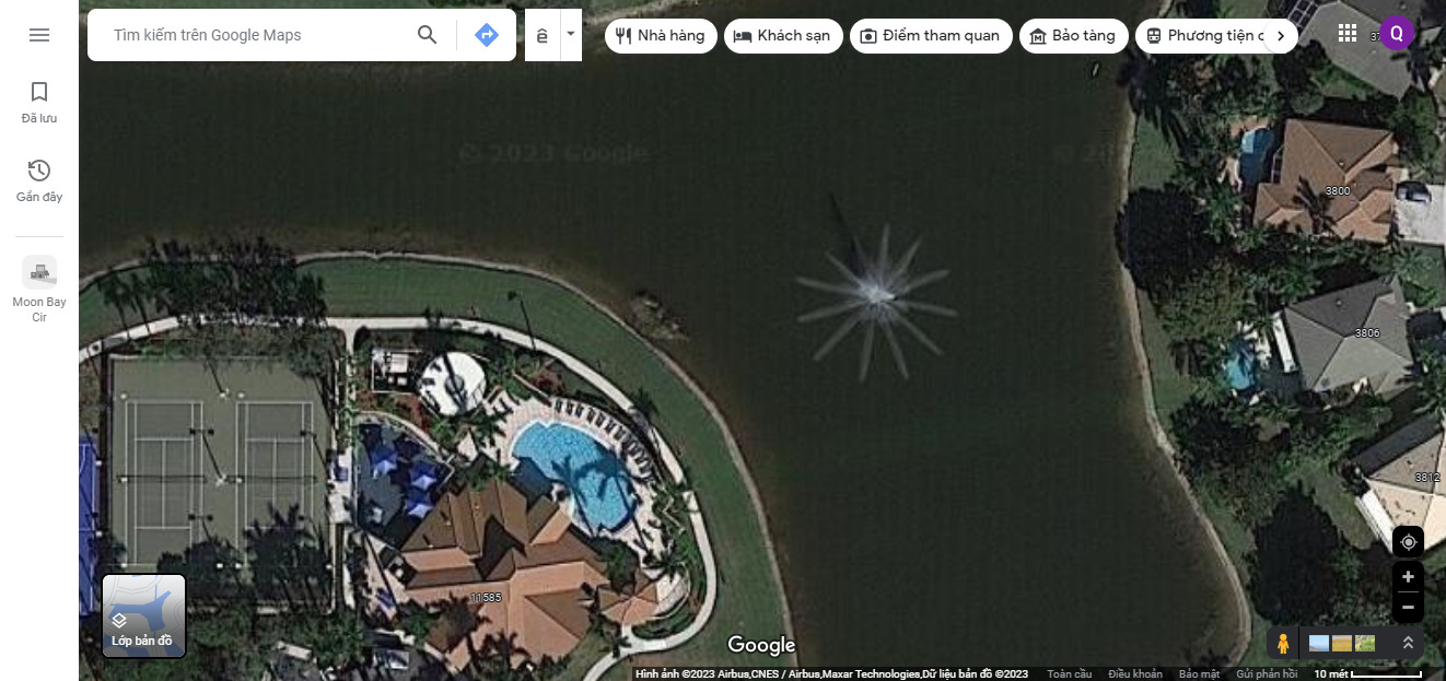
A 40-year-old man went missing after a night out. 22 years later, a local man was looking on google maps and spotted a car in the lake. When the car was searched, the missing man’s skeletal remains were found inside.
If you have access to the internet, which you clearly do because you’re here on Bored Panda (hi!), chances are you’ve used Google Maps before. When you visit a new place, need to get somewhere in a hurry, or are wondering how early you need to leave before heading to a date, this trusty map app is always there to help you out. Well, at least for the past 18 years it’s been there. Google Maps was launched on February 8, 2005 as a desktop platform that would help people “get from point A to point B”, and today, it’s used by over 1 billion people around the planet every month.
Shortly after Google Maps was released to the world, things got even more exciting. Google Earth came out a few months later, allowing us to view 3D images of the world on our desktop computers. Today, there are over 36 million square miles of high-definition satellite images on Google Earth, detailing over 20% of our planet. By December 2005, Google also launched Transit Trip Planner in Portland, Oregon, to help commuters view transit schedules and routes, but this feature was later added into Google Maps.
Another beloved feature of Google Maps is its real-time traffic updates. That dreaded red line that estimates how long you’ll be sitting in gridlocks came about two years after Google Maps was launched and is particularly useful for users living in big cities and with long commutes. Soon after, Street View finally came along, allowing us to suddenly be able to stroll down the street virtually, thanks to the help of cameras strapped onto everything from snowmobiles to camels.
And in November 2007, Google Maps introduced a platform that forever changed the way we travel: a mobile app. It was first available for Blackberry and Palm devices, then Androids in 2008 and finally iOS devices in 2012. By 2009, though, the app got an exciting update as turn-by-turn navigation was introduced. Suddenly, we were all able to hear that lovely passive-aggressive voice telling us to "Make a U-turn" over and over again until possible...
One Google Maps feature that you might not even be familiar with is Street View Trekker, which was introduced in 2012 to take the platform to new heights. By placing their high-tech photo capturing equipment into backpacks, Google sent hikers into the wild to start capturing places like The Grand Canyon and the Amazon rainforest. Even the top of the Eiffel tower can be seen through the lens of Street View Trekker.
By 2014, Google Maps began expanding even more, as they started adding more information to their apps, such as business hours, ratings, prices of restaurants, bars and hotels, etc. And this is why I’ve spent countless hours on Google Maps before. Because I’m constantly on the hunt for the best vegan brunch, coffee shops and cakes that can be found in any city I find myself in…
If you’ve been using Google Maps for many years, and you’re curious where your travels have taken you, you’re in luck! In 2021, Google launched the Google Maps timeline, which allows users to see where they’ve been on any specific day or any particular place. It can inform you how long you walked or rode on public transit, how long you stopped for coffee at that one adorable café in London, and what time you arrived at your hotel. While all of this tracking can sometimes be creepy, I have to admit I enjoy being able to see this information when I’m feeling sentimental and want to relive a particularly lovely experience.
While this article might be focusing on how silly and surprising Google Maps is, we have to give the platform credit for being impressively accurate most of the time, especially considering how rapidly it has improved. And if you’re curious how Google Maps manages to be so precise, look no further. Greg Miller wrote a piece for Wired exploring this exact topic. It turns out that one of the keys to Google Maps’ accuracy is just covering ground. They’ve had cars cover more than 7 million miles, which allows them to “algorithmically build up new data layers from information [they’ve] extracted”, Manik Gupta, group product manager for Google Maps, told Wired.
It's an art installation. Very realistic and creepy! https://www.thisiscolossal.com/2012/09/enormous-daddy-long-leg-spiders-overtake-the-seattle-armory/
“Those algorithms borrow methods from computer vision and machine learning to extract features like street numbers painted on curbs, the names of businesses and other points of interest, speed limits and other traffic signs,” Greg Miller explains. It can be tricky combining all of the information found on streets, signs, painted on lanes, etc., but Brian McClendon, Google Maps VP, says their technology on that front is improving as well. And when algorithms fail, Miller notes that, “Google employs a small army of human operators (they won't say exactly how many) to manually check and correct the maps using an in-house program called Atlas.”
Despite any bizarre locations or photos found on Google Maps, this platform consistently ranks as the top tier navigation system. “Google Maps covers more of the world than anyone else. Hundreds of millions of places are on the map in 220+ countries. So wherever you live in the world, Google is the most complete map you can find,” GIS Geography notes on their site. “By using machine learning, it’s how Google keeps its base map fresh and relatively error-free. Not only this, but they use the power of AI to navigate you through heavy traffic with real-time data. So when you’re on the move, no better GPS navigation app delivers like Google Maps.”
It's ok. That's just Fred. He likes to drink on Thursdays. He should be alright in a couple of days
Traveling is expensive and not always feasible for everyone, so why not take a journey on good old Google Maps? Clearly, you never know what you’re going to find, and you might just come across a hilarious landmark or feature that you’ll want to visit in person one day. I’ve personally used Google Street View with my parents to give them a tour of the city I live in, since they haven’t been able to visit yet, and honestly, it was a great way to get them excited for the trip. Google Maps can be used for much more than simply figuring out which bus to take in the morning (although it is great for that too).
Are you feeling inspired to go on a Google Maps adventure of your own to try and see what you can find? The world is your oyster, and clearly, there are many hidden treasures awaiting you on Google Maps. Keep upvoting your favorite pics on this list, and then if you’re interested in checking out a Bored Panda article featuring maps that might teach you something about our world, look no further than right here!
It's an RCS facility. For measuring radar cross sections of airplanes (and anything else). There are several in the south west of the U.S. The object to be tested is mounted on the right side of the strip, the radar (and other RF) signals are generated and measured by the antennae located of the left side. The strip is not for landing planes but for controlling radar reflections.
You guys are pessimists. That shed is not drowning. It is rising. It's probably a zombie shed rising up to take its revenge or something.
It looks like one of those studio pictures from Sears or JC Penny from the 1970-1980's.... ih1h7fsk98...62e0e6.jpg 
Looks like a rotating bridge that turns to the side to let ships pass
What ever it was must have been removed as there is nothing there now
https://www.queensland.com/au/en/things-to-do/adventure/diving-and-snorkelling/shipwreck-dives-queensland
It's their landmark. "You just walk till the Totalled Pickup and turn left."
https://www.dailymail.co.uk/news/article-2170984/Target-Yodaville-The-town-middle-Arizona-desert-built-U-S-Air-Force-practice-bombing-raids.html
Abandoned sunken tankers or container ships ... When you flip to 3D mode, you can clearly see rusting and hull cavities ...
Looks like they made some progress since this picture was taken. https://goo.gl/maps/o6GcLJXoWVqqXB3X6
It's a nature retreat/tourist attraction, with yurts and preserved forests.
to the percy jackson fans out there- i believe there is a random warehouse named Delphi's strawberry service somewhere in Manhattan? I have looked it up and found it before. also someone told me there is a place named camp half blood, but i havn't found it.
I haven’t read the Percy Jackson books, but I loved the Trials of Apollo
Load More Replies...if you want to see more of these go to neal.fun and click on wonders of street view theres heaps more of these and some of them are hilarious
#1 Listing is untrue. The car was located by a drone pilot. It was only after the fact that someone noticed the car could be viewed in Google Maps.
Can someone explain this: https://www.google.com/maps/@-3.5224538,23.5995146,3a,41.5y,323.97h,91.76t/data=!3m8!1e1!3m6!1sAF1QipP7j4_GcOo9Zs5RbXALMAbUE7rMr7EyEWXp3m-F!2e10!3e11!6s%2F%2Flh5.ggpht.com%2Fp%2FAF1QipP7j4_GcOo9Zs5RbXALMAbUE7rMr7EyEWXp3m-F%3Dw900-h600-k-no-pi-1.756471075980187-ya323.9704999956153-ro0-fo100!7i16384!8i8192?coh=205410&entry=ttu&g_ep=EgoyMDI0MTAxNi4wIKXMDSoASAFQAw%3D%3D
My favorite is this one, cracks me up 😂 A very aptly named street in the northern community of Iqaluit. If you continue passed the shooting range, you'll reach the actual "End of the road to nowhere". End of Road To Nowhere https://maps.app.goo.gl/qDaGt8TfsGkqfCtw7


 No fees, cancel anytime


. (67.8961230, 145.1598760)")

")


 Ditched In A Pond Near Key West, Fl")


")


")


")
")
")


")


")


")