For every Internet commenter who enters online arguments about the USA with facts they got from their butt, there's a map that presents hard data bare and allows the viewers to make their own interpretations.
From light pollution and tree coverage to out-of-service railways and streets and highways, maps may not immediately look as exciting as a viral cat video -- which might explain why we often overlook them when -- but that doesn't mean that are boring. To prove that, we put together a selection of maps that explain the United States better then most textbooks and if broadening your worldview isn't thrilling, I don't know what is.
This post may include affiliate links.
Most Commonly Spoken Language In The Us After English And Spanish


I am not surprised at all. I guess the Amish communities have a great deal in it
Load More Replies...It's a Native American tribe for those that don't know. ;)
Load More Replies...I live in Louisiana. The French here is not the same as European French. It really is a whole different language.
Is that in the same way that american english is different from british english? Different words for items (taps and faucets) and phrases eg This is different from (British) and this is different than (US). I can't come up with better examples off the top of my head, sorry!
Load More Replies...I genuinely learnt a lot from this map, but more so from the comments!
Illinois as an outlier with Polish, I actually think that's pretty interesting
So many Polish bakeries in Chicago - that wasn't a surprise to me though.
Load More Replies...National language of the Philippines. They have many smaller local languages as well.
Load More Replies...TAGALOG: from the Phillipines. "Tagalog (/təˈɡɑːlɒɡ/) (Tagalog pronunciation: [tɐˈɡaːloɡ]) is an Austronesian language spoken as a first language by the ethnic Tagalog people, who make up a quarter of the population of the Philippines and as a second language by the majority."
Doesn't (almost) each island have its own dialect, or separate language? Palawan, Mindanao, Cebu, Leyte, etc...
Load More Replies...Why Arabic in Michigan? Seems like a strange migration point for people of middle eastern decent. That is the strangest one in this entire map!
Henry Ford was well known for liking to hire Arabs. When the car industry was booming, the Arab world was in decline, so a lot of them left and went to Detroit for work. After Detroit took a downturn, less immigrants went to detroit, but Michigan was already established as a hub for Arabs, so they continued to settle in Michigan. The population continued to grow from that, and by them having more kids, so in non Arab nations, Michigan probably has the largest concentration of Arabs in the world.
Load More Replies...I think Indian people prefer England for some reason.
Load More Replies...Yes, Houston has a huge Vietnamese population. Many Germans also settled in Texas near San Antonio.
A LOT of Koreans end up in 3 areas, Atlanta, GA, W. Virginia, and Irving, CA. I check up on the Korean populations periodically, I want my kids to keep their Korean whenever we move back to America. I was planning on Minneapolis since there is a public bilingual Korean school there but not so sure now...
Load More Replies...I assume this means the language is spoken by immigrants and their direct descendants, not the language that is spoken by those who learned it as a second language? A line of my American family has spoken German for six generations, but for the last three generations we have learned it in high school and college, not from family speakers. (Sadly, the Welsh and Scottish was lost within a generation, as a response to bigotry and hatred from English descendants in America. Hmmm. Now, I understand why my Celtic immigrant ancestors married German immigrants!)
Cymru am byth! Getting revenge on those haters of centuries before. Enjoying Welsh folk music and learning of Welsh history and folklore. I honor my Welsh ancestors by attending a gmanfa ganu whenever I am able to.
Load More Replies...Thousands of place names in North America are derived from indigenous words, including half the States.
Load More Replies...Strange that this does not correlate with the map of most common country of birth for foreign born residents.
Why would that be? They are measuring different things, and thus would include subsets of different people. Basically, it means that people don't actually have to be foreign-born to speak a second language.
Load More Replies...usa an inmigrant land... multilingual and multicultural country,,,, this is the XXI century... not the XIX .... wake up.
I would think that Spanish would be 2nd in Florida....or even Hebrew/Jiddish.
German was almost our official language but lost in a vote to English.
And only one state (IL) has polish spoken as second most common. I am also surprised that only one state has Russian as tongue number two (OR).
I am surprised not seeing any indian languages... I mean from the country india
Not surprised about Arabic--we have a thriving Muslim population here. I am surprised that French Creole is in Florida and not Louisiana!
I majored in Geography. In one class we were assigned to know all the major rivers and mountain ranges in the world. I bought a bunch of blank world maps, and put rivers on one, and mountains on another one. I got an A on the test. It was much easier to learn that way than for the other kids who had it all jumbled on one map.
So how is it that I have such a hard time finding a German restaurant?
Who knew that Texas, Oklahoma, and Nebraska have such a high Vietnamese population?
The French ones speak to our history, but the German is a surprise.
Uhm.....while it's Arabic in the lower peninsula of Michigan (aka Troll country) it's Finnish in the UP; the UP is home to the highest concentration of Finns outside Europe.
Arabic in the lower peninsula (Troll Land) of MI....Finnish in the UP.
SD is the only state where the 3rd most commonly spoken language is Dakota. I would have guessed Lakota.
I thought German would be Pennsylvania since there are so many Amish and they don't speak English until they enter school age.
I noticed S. Dakota is colored pink, but it does not say French it says Dakota lol, cool facts though.
How about Athabaskan variations... Native American from Alaska to New Mexico?
Many of those Portuguese in Massachusetts come from the Azores. I learned that while living there.
Not surprises about French for the states that border Quebec, but surprised about German. Still a lot of French in the south!
That map is dated 2014. There's a much more diverse one from just 3 years later.
lived in Florida my whole life and never once have I heard or heard of anyone speaking French Creole
With the large Amish and Mennonite populations in PA, I thought it would be PA Dutch
Nope. Pennsylvania has a lot of Hungarian and Polish immigrants! I know because I am one of them!
LOL... my dad's entire family is partially responsible for Italian in Pennsylvania!
Wow... Texas has changed a lot in the last 20+ years since I left. Used to be Czech, Spanish, German were the top 3 (in order) after English.
Dakota is a Native American language. Also, that state is South Dakota.
Load More Replies...For people who think what is Tagalog, that is one of the Philippine language
je ne pas parle francais tres bien. j'ai un étudiant de français. please correct my spelling/grammar mistakes :) im still learning
I've been to every single one of those states and never heard anybody speak german...
Wow. THAT is a lot of German. I know many settled over there but I did not expect that.
Totally agree. But now I understand why so many Germans believe the urban legend that German had almost been the official language of the USA...
Load More Replies...Dakota is a language? Edit: I honestly didn't know it was a native language. Didn't mean to offend anyone. I've never even been in the US.
Yes, many locations in the USA are taken from local languages or even just the local Native American tribal name. Many of their languages share that name, Navajos speak Navajo for instance.
Load More Replies...The post read the most common language AFTER English or Spanish.
Load More Replies...Texas - not Spanish? I don't know anyone who speaks Vietnamese, but lots of people who speak Spanish.
The post read the most common language AFTER English or Spanish. Not sure what I was expecting, but it wasn't Vietnamese!
Load More Replies...Almost 45 million German-Americans live in the US. There are less than half a million Amish people. So no, he probably did not.
Load More Replies...There’s often overlapping features between maps. For example, a topographic map could be utilized to show the distribution of a local orchid, making it both a topographic and thematic map. It could also be used to show well-known features of specific interest to travelers making this topographic, general reference, and thematic maps all in one.
The most widely used maps are “Political maps”. They are the ones that are usually mounted on the walls of classrooms throughout the world. They show the geographic boundaries between governmental units such as countries, states, and counties. They show roads, cities, and major water features such as oceans, rivers, and lakes.
The United States Of America: Alaskan Perspective

Political maps are really good at helping people to understand the geography of the world. They are usually the first type of map that students are introduced to in school, too. They are often called “reference maps” because people refer to them again and again when they have questions.
According to Geology.com, thousands of different political reference maps have been prepared to explain the United States. There are maps of the entire nation, maps for each of the 50 states, and even maps of the 3142 counties (parishes in Louisiana, and boroughs in Alaska) that make up the states. Most counties, boroughs, and parishes are further subdivided into even smaller political units. An incredible number of political maps have been prepared just to display the geography of the United States alone.
How I, A Brit, See The United States (Sorry If It Offends Anyone)
")
Patrick McGranaghan, who is a land surveyor in Colorado, USA, and the creator of one of the biggest online cartography communities, r/MapPorn, did an analysis on its most popular posts on Twitter. McGranaghan collected the 10 best-performing posts from the previous 18 months -- about 200 maps in total -- and went through each of them individually, tagging them based on the content, style, and subject matter. He then sorted the tags to see which ones were the most common.
States With A Smaller Population Than Los Angeles County

"The most popular subject was history," McGranaghan told Bored Panda. "In this category, the most popular maps were about World War II." Maps about other wars were also well liked, as well as those about the ancient Romans and historic trade routes.
"Another popular category was natural science. Especially popular are maps about wildlife, such as those that use tracking data to show animal migration patterns. Other topics included geology and astronomic maps."
Interestingly, quite a few viral maps focused on language. These include etymology, dialect and various pronunciation maps.
US Watersheds

"Another topic that I grouped together are 'political re-alignments'. These are maps that deal with boundaries. Subjects like separatist movements, re-drawing borders, and user-created idealizations. Many of these are satirical and funny," McGranaghan explained.
McGranaghan, however, wouldn't say that all of these maps are scientific. "I think the data is a bit noisy, but it's interesting nonetheless. Users sometimes want a magic formula to make their maps go viral and I don't think there is one. The tastes of the masses are fickle and change over time."
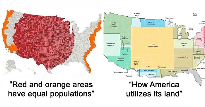
Red And Orange Areas Have Equal Populations

This is not at all surprising, since nearly half the population in this country lives within 30 miles of the coast.
When it comes to maps that best describe a country, McGranaghan thinks that it depends on the goal of the mapmaker. "All maps are generalizations, some good, some bad. They are not true representations and a good 'reader' should know that. I think good data visualization will take disparate datasets and find meaningful connections that weren't known before. It sounds simple but it is not so straightforward. A good mapmaker should be familiar with many matrices of knowledge and should be able to sift through them and make new connections."
McGranaghan created r/MapPorn in May 2011 while living in Taiwan, and it currently has over 995K members. He thinks the reason why the community is becoming so big is the same one why people like maps so much: they are easily digestible. So go ahead folks, continue scrolling and enjoy the rest of the post. Bon appétit!
United States Population Lines

The Most Efficient Route Between Every Springfield In The United States

Tree Cover Map Of The US

How Much Snow Does It Usually Take To Cancel Schools?

Nice. I always get a kick out of the places that close school for an inch of snow. You don't even need to wear a coat for 1" of snow.
Most Common Surname In The United States By State

Every State's Least Favorite State

Its Very Interesting

More People Live Inside The Red Area Than The Grey Area

... and this is the downfall of the American election system called the electoral college.
Drug Overdose Deaths In The United States Per 100,000 Persons For 1999 And 2014

US States Scaled Proportionally To Population Density

The Loudest And Quietest Spots In The Continental US

my house is in the border of very loud and very quiet. I can hear trains, a freeway, coyote howls, and owls hooting.
Out Of Service Railways

The U.S. Mapped By Residents’ Desire To Move To A Different State

Use Of The Word "Dang" Across The Continental US

How America Utilizes Its Land

Percentage Of People Born Outside The U.S. In Each State

Regions Of The U.S. That Don't Officially Celebrate Christopher Columbus Day

Popular Coffee Shop Chains By Number Of Locations

Map Of Lowest Recorded Temperature In Each Us State (Fahrenheit)
")
This is Hilarious to me, my ex-husband was raised in Alaska from 7 year's old until 22 year's old & heard a ton of weather stories 😅 😄 😂 😆 🙃 🤣 😅 😄 I've been there 4 time's but alway's in summer though!
Light Pollution In The United States


Air Traffic Control Zones In The USA

U.S. Education Spending Map

Explains why so many US citizens show a heartbreaking ignorance and why a guy like Trump could become president.
Map Of The United States' 8 Million Miles Of Roads, Streets And Highways


USA Tree Diversity

Garbage Can vs. Trash Can In The United States

Portion Of Each State That Is Federal Land

All U.S. Counties With In-N-Out Burger As Of May 2020

A Tastier Map

Date Of Creation Of All 3,142 U.S. Counties

US Governors By Eye Color


Voters Who Didn't Vote For Hillary Or Trump

Average Size Of US Apartments By Region

Results Of The 1984 United States Presidential Election By County. The Most Lopsided Election In History, The Only State Reagan Failed To Win Was His Opponent’s, Minnesota

In reverse, this must be the outcome of the 2020 election. Trump is setting up the "corrupt election" playbook so that when he loses, he can claim the election was fraudulent. We need to do the same thing Reagan did and OVERWHELMINGLY vote the morbidly obese pathological lying vindictive narcissistic imbecile with the emotional maturity of a toddler (AKA tRump) out of office.
US Counties With Gdp Over $100b

USA Country Map Divided By 1/3rds Of Covid Deaths


As an American, I would be really interested in seeing maps like these for the UK and Europe.
Ooooh, id love to see that. You could use adoption data. You could also do one by most spent on vet bills and most food and toys purchased.
Load More Replies...Very interesting set of maps. I just wish they had a higher res ones because some of them were really hard to read.
yes and even if you could read them I still didn't understand some of them, like the light pollution one? Maybe I'm alone but whatever I just agree with jamie1707
Load More Replies...Trump wanted the electoral college defunded because he's against all that fancy edjumacation. His magic 8-ball beats any stupid scientists and their technologeez and advanced mints any day!
Load More Replies...more, please! Ma, Mom, Mama, Momma, Mother etc; Dad, Pop, Papa, Pa, Father, etc; education - and types of education; sleep patterns; loneliness; favorite fairy tales . . .
Most of those were interesting. The political ones, not so much. People's remarks just get rabid.
Quite annoying that when I entered a comment, you wanted me to log in. After I did so, I was taken back to the top of the story and when I scrolled down to see my comment, it had been disappeared. If it "works as designed", the designers need another needs analysis session.
I enjoy these maps. When we were looking for job interviews in locations we would like to live, we shaded areas color coded for forest, climate and bear habitat, correlated with job openings. Then we constructed a travel plan to interview in those places. It was remarkably effective strategy, and helped us focus our search. Searching by animal habitat was interesting as well.
The waffle house map doesn't make sense. The numbers are wrong if this is number of individual stores.
Awesome information. How did they find this information and I can’t find specific information shopping on the internet? I ask for “x” and “a,” “b,” “y,” and “z.”
What great way to show people why we have an electoral college, and why we WONT let California or New York elect our president...
Tyranny to the minority is soo MUCH better than tyranny to the majority. /s
Load More Replies...Pro tip; if you want people to take you seriously, learn how to spell
Load More Replies...None of this had anything to do with that. If you're going to take a poke at us, at least make it relevant.
Load More Replies...I don't think you realize how large the United States is. Many of our states are larger than European countries.
Load More Replies...The name of the continent is North America. Even if one accepts the argument that N and S America are a single continent, the accepted demonym for citizens of the USA is "American".
Load More Replies...As an American, I would be really interested in seeing maps like these for the UK and Europe.
Ooooh, id love to see that. You could use adoption data. You could also do one by most spent on vet bills and most food and toys purchased.
Load More Replies...Very interesting set of maps. I just wish they had a higher res ones because some of them were really hard to read.
yes and even if you could read them I still didn't understand some of them, like the light pollution one? Maybe I'm alone but whatever I just agree with jamie1707
Load More Replies...Trump wanted the electoral college defunded because he's against all that fancy edjumacation. His magic 8-ball beats any stupid scientists and their technologeez and advanced mints any day!
Load More Replies...more, please! Ma, Mom, Mama, Momma, Mother etc; Dad, Pop, Papa, Pa, Father, etc; education - and types of education; sleep patterns; loneliness; favorite fairy tales . . .
Most of those were interesting. The political ones, not so much. People's remarks just get rabid.
Quite annoying that when I entered a comment, you wanted me to log in. After I did so, I was taken back to the top of the story and when I scrolled down to see my comment, it had been disappeared. If it "works as designed", the designers need another needs analysis session.
I enjoy these maps. When we were looking for job interviews in locations we would like to live, we shaded areas color coded for forest, climate and bear habitat, correlated with job openings. Then we constructed a travel plan to interview in those places. It was remarkably effective strategy, and helped us focus our search. Searching by animal habitat was interesting as well.
The waffle house map doesn't make sense. The numbers are wrong if this is number of individual stores.
Awesome information. How did they find this information and I can’t find specific information shopping on the internet? I ask for “x” and “a,” “b,” “y,” and “z.”
What great way to show people why we have an electoral college, and why we WONT let California or New York elect our president...
Tyranny to the minority is soo MUCH better than tyranny to the majority. /s
Load More Replies...Pro tip; if you want people to take you seriously, learn how to spell
Load More Replies...None of this had anything to do with that. If you're going to take a poke at us, at least make it relevant.
Load More Replies...I don't think you realize how large the United States is. Many of our states are larger than European countries.
Load More Replies...The name of the continent is North America. Even if one accepts the argument that N and S America are a single continent, the accepted demonym for citizens of the USA is "American".
Load More Replies...