Get Premium
Dark mode theme is available exclusively for premium users. Learn more about the benefits of subscribing.
No fees, cancel anytime.

 Dark Mode Ad-Free Browsing Unlimited Content
 Ad-Free Browsing Unlimited Content Dark Mode
Join 1.2 million Panda readers who get the best art, memes, and fun stories every week!
For many of us, cartography day in geography or history class meant a quick nap. With our eyes open, we’d dream of all the delicious stuff we were gonna eat after school, of music we’d play on the Walkman, of a message we received the other day from that cutie…
To bring back our long-lost excitement for hard pieces of data, aka maps, plans, and geographic drawings, we're gonna need to start from the very best of them. Luckily, there’s a whole online community on Reddit dedicated to the most unusual charts of geographic areas that took maps to a whole new level.
From mapping "October" in European languages to mapping an eagle’s track over a period of twenty years, these incredible examples will surely put the world into a completely new perspective.
Who knows, you may well unleash your inner cartographer and become among 1.1 million like-minded members of the maps subreddit. In that case, you may need some more cartographical goodness with 41 maps that portray lesser-known facts about America.
This post may include affiliate links.
To find out more about this amusing Reddit community by the name r/MapP**n, Bored Panda reached out to its creator Patrick McGranaghan, who started the subreddit in 2011 while living in Taiwan.
Patrick said he has always been a map geek: “I wanted people to share those maps so that they are easy to find and discuss.”
It turns out, he works as a land surveyor in Colorado and is a devoted member of several map societies across the nation, including the North American Cartographic Information Society, Charles Close Society for the Study of Ordnance Survey Maps, and Rocky Mountain Map Society, to name just a few.
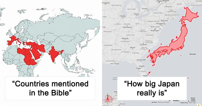
Okay, mind blown; it's literally twice as big as I'd imagined given typical maps. Thank you, person who made it!
The creator said that the title r/MapP**n followed the trend on Reddit at the time when “there were a lot of subreddits with a *-porn suffix.” He explained further: “This refers to pictures of innocuous things like nature, architecture, or engineering marvels in a beautiful way. It was not meant to be sexual. The internet at the time was a lot more relaxed and using that term was funny.”
“In the years since the culture on the internet has taken a much more puritan bias and some people don't like that name,” Patrick said.
However, he assured us that “the goal of the brand has not changed, though: it's a place to share and discuss beautiful maps.”
To be honest, only the Centering of 0-meridian to britain is arbitary.. location of 0 latitude at the ecquator is quite natural selection.
When it comes to submissions, they come in every form and style. “From historical maps showing ancient borders, to funny memes and transit maps. People also post imaginary maps of places that they create in their minds.”
In fact, every kind of map imaginable has been posted to this subreddit. Patrick said that linguistic maps are popular, as well as maps that re-imagine state and national borders. There are also maps of asteroids and maps of routes of famous explorers.
“One of my favorite interactions is when a map is posted of an obscure place and someone in the comments says they live there or has a story about that place.”
Wow, I never knew this. Unlikely Jesus was fair skinned, blond and blue eyed....
Patrick concluded that “Maps are a way to visualize the world in a way that is easy to grasp. They are an aid in learning about new lands and faraway places. They help us find our way when we are lost.”
Especially in a time like now, “when the pandemic prevents us from traveling, maps are a way that we can travel without leaving our home,” the map enthusiast said.
The map is not quite correct. On Antarctica, penguins also live only in the coastal region and not as far inland.
ALSO THERE ARE PENGUINS THAT ARE SMALL AND BLUE AND THEY'RE CALLED BLUE FAIRY PENGUINS I RECOMMEND YOU LOOK THEM UP THEY'RE THE ONLY THING YOU NEED TO SURVIVE download-5...d8e88.jpeg 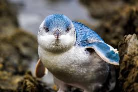
Yes,when I lived in Lima, Peru, I saw a penguin walking past my house!
I live here I've always taken penguin for granted...you can go out and watch them going out to sea or coming back at the end of the day. Waddle waddle indeed :)
Load More Replies...I lived in Brazil for 2 years in the 1960s and spent 6 months of that time in the town of Blumenau. On one occasion I traveled to the coastal village of Itajai, a short distance away. At the beach there we saw a number of penguins swimming in to the shores. So I know that they travel at least that far north along the eastern coast of South America. Blumenau is about 2300 km north of Bahia Blanca.
Here is a more detailed map: http://www.penguins.cl/penguins-region.htm
Here in Tauranga, New Zealand, we have 1,300 little blue penguins reside around Mauao...a dormant volcano at the end of a peninsula. Only 10kms from our hone. Regularly see orca, dolphins..,and stingrays too. Paradise.
And this is also because all of those continents were once connected, right? Panagea or something?
i didn't think they would be so close to the equator! i mean i know they don't all live in antartica, but still!
Now for the real fact: Actual penguins are extinct and were from north of the equator. What are now called penguins were named thus because of their resemblance to the extinct species by Europeans.
I knew of the Great Auk (horrible story of their extinction) but I didn't know current penguins were named after them because of their similar appearance. Pinguinus impennis...had me remembering the Swiss animated program Pingu. (After reading your comment I read more on the Great Auk history and sadly, more animals that are now threatened with extinction). Cheers
Load More Replies...Really mods? The penguin's name was Chilly W***y not chilly 🍆🙄
Load More Replies...In Chile and Australia and New Zealand too? Didn't know they had penguins there
I've seen them in Australia, tiny little fairy penguins.
Load More Replies...Pengiuns DO live in Scotland, not put there as stated Some people think they know everything and yet they are Wrong
They were connected years ago. Look for Pangea. Continents are still moving and they're slowly joining "by the other side".
Load More Replies...Oh for cripes sake, what’s wrong with me. I thought they were in the North too
And one living in Bloom County - but he's not talking about how he showed up there. ;)
There's a colony of Fairy Penguins in Sydney (suburb of Manly)
Load More Replies...Why is the Galapagos not on the map? It has the only penguin species found north of the Equator.
I didn't know there was an ice-wall between Finland and Russia!?! (Do I need to write 'Sarkasm'?)
In the "australia" map.... that little pink line above the "L", is actually New Zealand - a totally separate country to "Australia" (although the Aussies & Kiwis do consider themselves like "siblings" ie we are staunch rivals within sports, but stick together in defense of eachother).
Staggering. I appreciate this done for affect, but I would be interested in Mexico's figures.
In German ist would be Johann/ Johannes first, Jan and Hans are shorter versions
But Caspian Sea is a sea. 🌊 (It’s a joke for those who are gonna complain in the reply section)
You only call New England "small and confusing" because you are still wondering how you lost it (no offense, just joking! Seriously).
Thank you in Irish is Go Raibh Maith Agat ( Pronounced Go Ro My Aggat. Thank you in Welsh is Diolch (pronounced Diolsh).
If you would get 50.1% of the vote of each red-coloured state, 22% of the population of the country, you would become president, even if 78% of the country voted for another person, this is assuming that 49.9% of people in the the red-coloured states voted for the blue party, and 100% of the people in the blue-coloured states voted for the blue party.
NOTE: The colours dont mean anything
Span, Italy, and Romania apparently don't have Motorcycles. They have Tron Light Cycles!
They should rename the Province to "Not Vancouver", then make Vancouver a City State.
@I’m not even going to try to write that out, as it would give me an aneurysm, it is, in fact, the nearest country to you when in Russia
I want to live somewhere where I have to where a light jacket in summer and I'm snowed in during winter. I'm tired of sweating mid October.
Hello :) #24 is made by us at https://fb.com/indiainpixels - as the watermark says. Could you please source us instead? Thank you
Nearly all parts of knowledge are mixed like a kaleidoskop -fantastic
One of the most interesting things I've recently found on Bored Panda:) Love it:)
Hello :) #24 is made by us at https://fb.com/indiainpixels - as the watermark says. Could you please source us instead? Thank you
Nearly all parts of knowledge are mixed like a kaleidoskop -fantastic
One of the most interesting things I've recently found on Bored Panda:) Love it:)


 No fees, cancel anytime


 Referred To It In Various Forms Of The Word \"Cha\". On The Other Hand, The Countries That Traded With China Via Sea - Through The Min Tan Port Called It In Different Forms Of \"Te\"")


")


")
")


")


")