Get Premium
Dark mode theme is available exclusively for premium users. Learn more about the benefits of subscribing.
No fees, cancel anytime.

 Dark Mode Ad-Free Browsing Unlimited Content
 Ad-Free Browsing Unlimited Content Dark Mode
Join 1.2 million Panda readers who get the best art, memes, and fun stories every week!

There’s a wonderful online community on Reddit that’s dedicated to beautiful, intriguing, and artistic maps that will wow you and make you see the world from a whole other perspective. As someone who loves doodling maps in my spare time, I’m in heaven. And even though our generous and benevolent social media overlords [cough cough] don’t allow us to mention the full name of the subreddit because of one particular word that it uses, make sure you visit the group, check out their latest maps, and maybe even become members yourselves, dear Pandas!
In the meantime, let’s enjoy some gorgeous and interesting maps, shall we? Remember to upvote your fave pics as you continue scrolling. In need of an extra mega map fix? You’ll find Bored Panda’s previous posts about the ‘Map [Whoops Can’t Mention That Word Here Anymore]’ community right here, as well as here.
We reached out to the founder and moderator of the subreddit, Patrick McGranaghan. He told Bored Panda all about how his passion for maps was first sparked, as well as how amateur cartographers can develop their sense of style and design to create better maps and do their imaginations justice.
More info: Reddit | Twitter | Tumblr
This post may include affiliate links.
That's wonderful. It's so nice to see animal or bird populations increase like that. Thank you to all the conservationists who are making that happen.
"I developed my passion for maps very early. My family traveled and moved around a lot. My dad taught me how to read maps and I would help him navigate. I used to flip through our Rand McNally atlas to pass hours traveling across the countryside. Maps are invitations to explore and visit new places. They give security in the knowledge that there's a way to get to your destination. If all else fails, a map will be your guide," Patrick shared how he first became acquainted with maps and how his passion grew. It hits close to home.
Patrick also reminisced about the moment he came up with the idea for the subreddit, back when he was living in a small flat in Taipei, in Taiwan. "I knew that I had a good idea and it felt almost electric. Like a fork in the road and your destiny is changing. When I moved back to the states I was able to find a career making maps (as a land surveyor) and I am grateful every day that I can do something that I love."
Doing what we love for a living is a godsend. And though everyone might be there, plenty of us have felt the 'electric' feeling that Patrick's talking about where genuine excitement meets the potential for greatness.
Even though a lot of the amateur cartographers found on the subreddit have great ideas and are overflowing with creativity, their execution needs work to make the end results look less "hasty and skeletal." Patrick explained that some people need to develop their tastes for style and design. Luckily, he had some helpful tips for you and me.
"It is not that they are bad, it's just that they don't know that they can make their maps so much better. I'm talking about things like fonts and information boxes, detail and vicinity maps, adding gradients to water features, thoughtful color choices, shadows behind place markers. The subtleties are what make maps exquisite," he detailed.
During the Dust Bowl in the US Midwest, President Roosevelt implemented a program to plant trees in rows as windbreaks to stop the wind from ripping up bare topsoil. The program worked well, and you can still see some of those trees standing today.
"The best way to learn how to do these things is to look at lots maps and see how other cartographers solve these problems. Imitate the masters. Read a few books on cartography and design. Some of the books that influenced me are 'Info We Trust' by RJ Andrews, 'Cartography' by Kenneth Field, and 'Things Maps Don't Tell Us' by Armin Lobeck. If you can integrate the ideas in these books you'll be a league above the average amateur cartographer."
As for the future? Patrick's waiting for the Covid-19 pandemic to die down and go traveling again. Among his plans is visiting the Baltic countries, especially the Soviet map store in Latvia.
Can't tell but did they use a ☘ shamrock for Ireland (can't zoom in close enough 🙁) ?
Lol at first I thought it was just saying that there were only two wolves left in 2020.
With nearly 1.3 million members, the map-loving subreddit is a cartography powerhouse on the net (and it’s making me itch to start drawing a few maps of my own again). In June of 2020, the subreddit had just shy of a million members, so they're continuing to grow steadily.
The group has been on Reddit since the late spring of 2011 and will be looking forward to its 10th birthday in just a few short months. What with the rise and fall of online groups every single day, reaching the decade-long mark is no easy feat and it speaks to the quality of the content they share.
To anyone wondering about why it's just Indo-European languages depicted: This info-graphic is part of a comic set in post-apocalyptic Scandinavia. A pandemic has killed most humans (and other mammals, too) and turned surviving infected into zombie-like creatures. The survivors have turned back to their old gods and rely on mages and cats to guard them from the trolls and beasts roaming in the un-cleansed areas. Stand Still, Stay Silent: http://sssscomic.com
In previous interviews with the founder of the subreddit, Patrick, Bored Panda learned all about the history of how the group was founded, as well as what kinds of maps you can expect to find. Patrick, a land surveyor from Colorado, founded the community while he was living in Taiwan in 2011.
A map geek through and through just like some of my colleagues and I, Patrick wanted to create a place where people could easily find and discuss beautiful maps. Patrick is also a member of the North American Cartographic Information Society, the Carles Close Society for the Study of Ordnance Survey Maps, the Rocky Mountain Map Society, among other groups.
According to the founder, there was a time not too long ago when the internet was much more chill about using certain words while naming online groups. “In the years since the culture on the internet has taken a much more puritan bias and some people don't like that name,” he explained and I can’t help but agree with him—you have to really watch what you write and say nowadays. And the internet sometimes seems like it doesn’t understand subtlety, sarcasm, irony, or jokes anymore.
Patrick explained to Bored Panda that there’s a bit of everything for everyone in the group: from historical and funny maps to imaginary and linguistic maps and more. “One of my favorite interactions is when a map is posted of an obscure place and someone in the comments says they live there or has a story about that place,” he said.
“Maps are a way to visualize the world in a way that is easy to grasp. They are an aid in learning about new lands and faraway places. They help us find our way when we are lost,” Patrick pointed out, adding that during the pandemic they can be great ways for us to travel while staying at home.
I distinctly remember flocks and flocks of Flamingoes in Jamaica Bay in New York City as a child, seeing them from the train on the way to the Rockaways...
Plastic Flamingos are actually a product of a company called Union Products, which is not in Florida. People in Florida think they're tacky and (outside some specific snowbird neighborhoods in Miami) are a joke... Usually to piss off neighbors. Fun fact: the plastic flamingo is the official bird of Madison Wisconsin.
Load More Replies...Flamingos on Aral mer must be bummed. Soon there wont be enough water left to flush a loo
That little pink park of Mexico is the Yucatan. I have a home there. I've visited the flamingo nesting grounds a few times ... beautiful.
One of the categories on the subreddit is dedicated to political realignments that redraw borders and all I can say is that I’m a major fan. They’re imaginative, creative, funny, and make us look at history in an entirely different way. Playing ‘what if…’ games is a lot of fun.
Why do people love maps? Because they’re aesthetic. Because they’re like picture books for adults. Because you can get lost in them for days and they awaken your sleeping desire to go on an adventure. Because they reveal a novel way of looking at life that we’re not used to. And because squiggly lines are fun to draw. Or at least these are all the reasons why I love cartography (yours might be different).
Does anyone tilt their head and see it as a lizard chilling on a mossy rock?
Personally, I don’t mind that the map precedes the territory, no matter what Jean Baudrillard says. Why? Because, like unusual and intriguing books, they have ways of sparking new ideas and expanding our minds. Who needs the actual territory when we have such gorgeous maps to look at from the safety of our homes?
Which map was your favorite one and why? What’s the most aesthetic or interesting map you’ve ever seen in real life? Do you have any maps at home? Are you a major geek like me and love drawing maps for your Dungeons & Dragons groups (I hope I’m not alone!)? Share your thoughts and, hopefully, your love for maps in the comment section below.
So you people really need to keep buying those filthy food products full of palm oil ? Please just watch their ingredient list, and boycott them.
To paraphrase Terry Pratchett: All roads lead away from Rome. People just occasionally walk the wrong way.
Minnesota has one of the highest concentration of Somali immigrants. Might be the highest concentration of Somalis outside of Somalia iirc, but that might be wrong.
Call it whatever you want. It’s about the American people vs the electoral college. It only feels regional because we don’t count people’s individual votes. The only moral way to is to count each persons vote equally.
Legit question - what is the difference between Holland and the Netherlands? Is Holland just one province? Tia!
When Rome defeated an area, they would assimilate those soldiers, and then send them to other areas. So you might get a Spaniard in Israel, a German in Algeria, and a Morrocan in England!
Since there seem to be a dozen districts listing "other" it seems worthwhile to break that down a bit further. What are the "other" options?
Ireland: Eire, Scotland: Albain, Wales: An bhreatain Bheag, England: Sasana, Portugal: An phortaingeil, Spain: An Spainn, France: An Fhrainc, Belgium: An Bheailg, Luxembourg: Lucsamburg, Holland: An Isiltir, Germany: An Ghearmain, Poland: AN Pholainn, Swizerrland: An Eilbheis, Italy; An Iodail, Denmark: An Danmhairg, Norway: An Ionua, Sweden: An tSualainn, Greece: An Ghreig, Turkey; An Tuirc, Romania: An Romain, Austria: An Ostair, Russia: An Ruis. This is all without accents, and based on my (very rusty) ability to read Irish Orthography.
Germany mainly split into Catholic or Protestant in the 16th century after Luther. In any area, if the top ruler stayed Catholic or became Protestant, the region followed suit. They have stayed mostly the same for 500 years. Obviously, the black/grey part results from Communist rule, which is generally hostile toward religion.
The map should be bright white, as the sun never sets on the British empire and the entire kingdom's a charred wasteland.
the north dakota one is NDSU :) (that's the one I'm most familiar with)
Most of the land in the west is owned by the federal government ... hence why so few people live in those areas. As an example, 85% of the land in Nevada is owned by the federal government.
My dude is the JRR Tolkien of maps instead of languages
If the U.S. is always that blown up on maps, maybe it's overcompensating for something
Italy over here not killing anything. Just catching pigeons with fava beans. Love it.
Someone also made a map of the Mediterranean superimposed over the US.
Fun Fact: Every country's province flag designs can be put on a scale from Japan to Liberia.
I would imagine that Spain is high on the scale because each household is "allowed" to grow 2 cannabis plants per year.
Funnily enough, that's also almost a perfect map of the insurance claim regions for total loss valuation on automobiles.
It used to be a pair of lips turned sideways to surround the word, and then it evolved into each of these.
My wife and I took a ferry there from Vancouver for a few days and wish we spent the entire vacation there. Amazing and beautiful place.
That Great Lakes mega region is a bit far fetched. You can drive for hours without seeing a town, building, et in many places.
It's as if all the Abraham Lincoln voters are attracted to red areas.
Inaccurate. The average American would never be so specific, much less know where NASA is located.
I’m surprised that’s it. I hope this number grows. Also don’t forget PR!
Poor Kentucky is absolutely surrounded but gets no shine! Where was the Torkelsons set? It’s hard to see most of this on mobile.
It says DC is never, but DC isn't a state, so it doesn't get to vote in federal elections.
Glad you love it, Aragorn! Do you by any chance have any great maps of Middle Earth to share with us? :)
Load More Replies...I was on this post for almost an hour! I really enjoyed it.
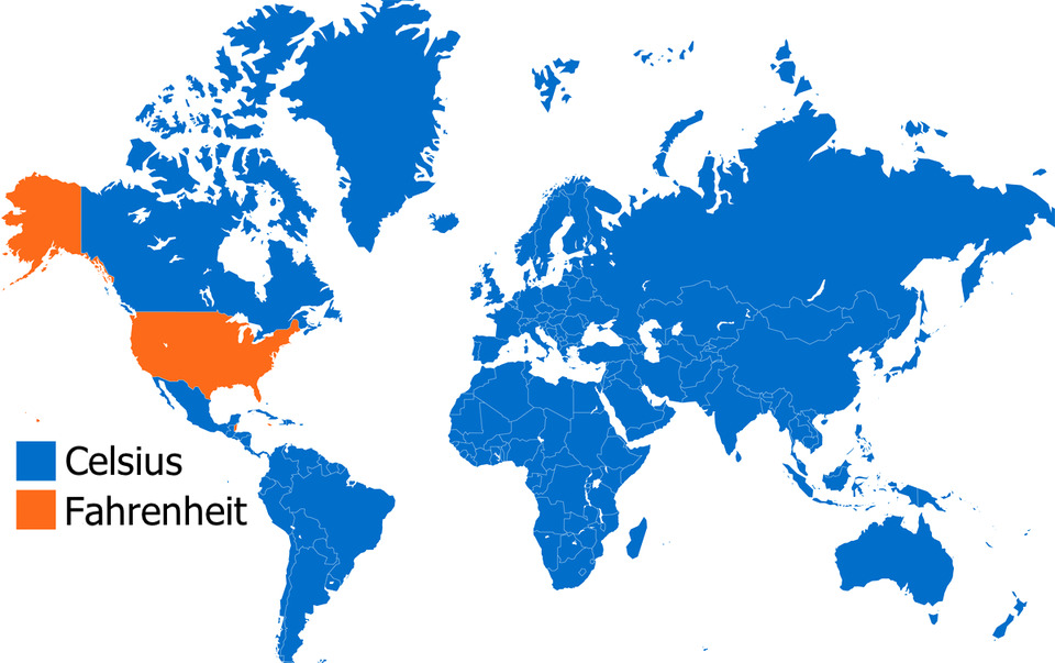
The mapmaker forgot Belize, Palau, the Bahamas and the Cayman Islands which all use Fahrenheit. As for "precision" all that is meant is the smaller difference between individual degrees but most humans can't perceive that small a difference, especially with wind chill, so the point is moot. And, btw- when Fahrenheit invented his thermometer he was trying to compute a scale for measuring body temperature so he chose 100º but his thermometer was off so it when more accurate thermometers came along the 'normal' body temperature had to be back-scaled to 98.6ºF.
Load More Replies...The bottom ones don’t even get a chance because they start off too far down and the list is overwhelmingly long. Just sayin. I know it gets condensed later but the bottom ones don’t get a chance to make the top 40, nobody sees them to upvote them.
My coin dish is a cast aluminum casserole dish in the shape of the continental US. It's weird because compared to most casserole dishes it's tiny, only 12 inches/30.5cm. I can understand wanting to make small baked dishes but why would you want one with that shape? My best guess is for loners who want to celebrate the Fourth of July by themselves. 20210221_1...19875b.jpg 
I loved this post! Went through every map. It inspired me to google all sorts of new things!
Fascinating maps. 🤩 There should be like a museum if it doesn’t exist all on maps! 🗺
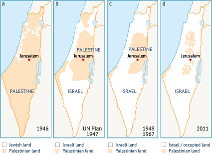
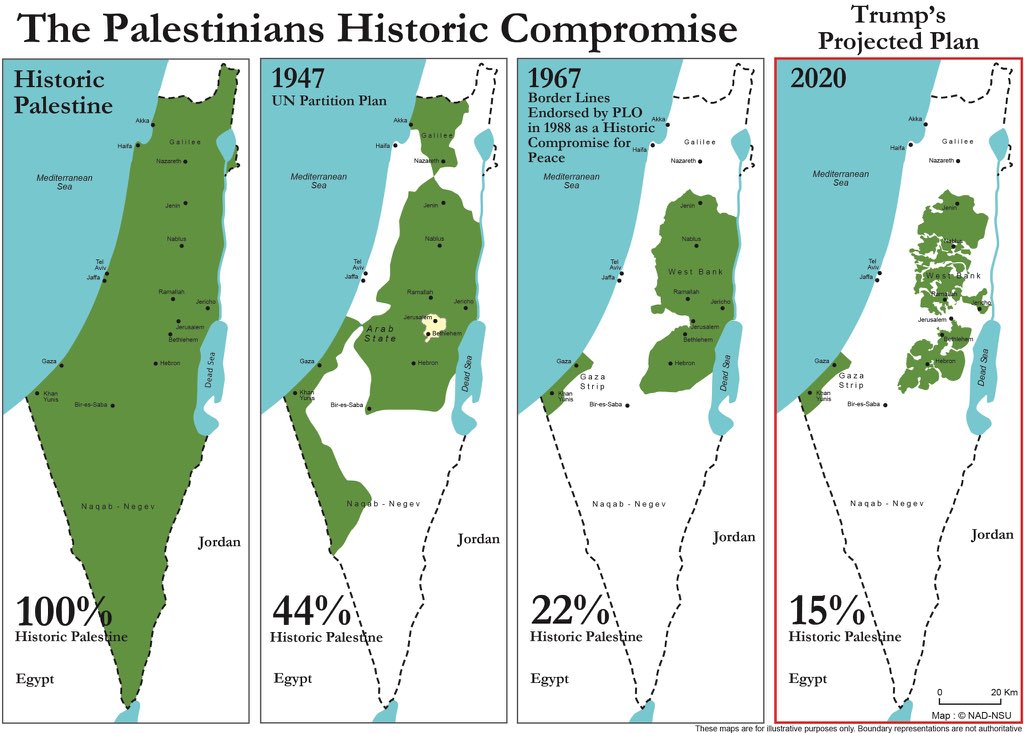
Can they show a map of PALESTINE and how much of the Israelies have taken by force?
That would be all of it... One of tbe few times in history a country has actually seized an ally's territory after a war.
Load More Replies...For everyone who is wondering why Germany has the railway saying. It comes from the time of WW1 when the word Railway was said in the trenches it meant that you could go home so everyone was listening to hope to hear it. It basically means I heard what you said but don’t understand
Wonderful post. I really love to add another map, but I think this list is closed?
Glad you love it, Aragorn! Do you by any chance have any great maps of Middle Earth to share with us? :)
Load More Replies...I was on this post for almost an hour! I really enjoyed it.
The mapmaker forgot Belize, Palau, the Bahamas and the Cayman Islands which all use Fahrenheit. As for "precision" all that is meant is the smaller difference between individual degrees but most humans can't perceive that small a difference, especially with wind chill, so the point is moot. And, btw- when Fahrenheit invented his thermometer he was trying to compute a scale for measuring body temperature so he chose 100º but his thermometer was off so it when more accurate thermometers came along the 'normal' body temperature had to be back-scaled to 98.6ºF.
Load More Replies...The bottom ones don’t even get a chance because they start off too far down and the list is overwhelmingly long. Just sayin. I know it gets condensed later but the bottom ones don’t get a chance to make the top 40, nobody sees them to upvote them.
My coin dish is a cast aluminum casserole dish in the shape of the continental US. It's weird because compared to most casserole dishes it's tiny, only 12 inches/30.5cm. I can understand wanting to make small baked dishes but why would you want one with that shape? My best guess is for loners who want to celebrate the Fourth of July by themselves. 20210221_1...19875b.jpg
I loved this post! Went through every map. It inspired me to google all sorts of new things!
Fascinating maps. 🤩 There should be like a museum if it doesn’t exist all on maps! 🗺
Can they show a map of PALESTINE and how much of the Israelies have taken by force?
That would be all of it... One of tbe few times in history a country has actually seized an ally's territory after a war.
Load More Replies...For everyone who is wondering why Germany has the railway saying. It comes from the time of WW1 when the word Railway was said in the trenches it meant that you could go home so everyone was listening to hope to hear it. It basically means I heard what you said but don’t understand
Wonderful post. I really love to add another map, but I think this list is closed?


 No fees, cancel anytime


")


, The African Union Is Leading An Initiative To Plant The Great Green Wall, A 7,775 Km (4,830 Mi) Belt Of Trees Crossing The Entire Breadth Of North Africa")


")


")


")
")
")


")


")
")


. Officials Blame Unvaccinated Animals From North Korea Crossing Into The South Through The Porous Dmz")


 - Would Be Interesting To See How Different This Is In 10 Years Time")


")


")


![Europe (Detailed) - Ad 1337 - [6637x4983] [oc]](https://static.boredpanda.com/blog/wp-content/uploads/2021/02/602d118566f68_vlfxej9qb1g61__700.jpg "Europe (Detailed) - Ad 1337 - [6637x4983] [oc]")


")


")


![Exaggerated Elevation Map Of California [oc]](https://static.boredpanda.com/blog/wp-content/uploads/2020/12/5fe34ee73e89b_jijfes35zmy51__700.jpg "Exaggerated Elevation Map Of California [oc]")


![Average Elevation Above Sea Level Of European Countries [oc]](https://static.boredpanda.com/blog/wp-content/uploads/2021/02/602d0ec407adc_th4sqxf1teh61-png__700.jpg "Average Elevation Above Sea Level Of European Countries [oc]")

 Make A Topographic Pie Of The United States")


![Urban Megaregions Of The United States [oc]](https://static.boredpanda.com/blog/wp-content/uploads/2021/02/601d61be93677_i8ltr3zlxoe61-png__700.jpg "Urban Megaregions Of The United States [oc]")


![Europe (Detailed) - Ad 1066 - [6637x4983] [oc]](https://static.boredpanda.com/blog/wp-content/uploads/2020/12/5fe350dd2624e_8nj8ke2sqr061__700.jpg "Europe (Detailed) - Ad 1066 - [6637x4983] [oc]")


")


 And Last Night's Democratic Victory")


")
")
")