Get Premium
Dark mode theme is available exclusively for premium users. Learn more about the benefits of subscribing.
No fees, cancel anytime.

 Dark Mode Ad-Free Browsing Unlimited Content
 Ad-Free Browsing Unlimited Content Dark Mode
Join 1.2 million Panda readers who get the best art, memes, and fun stories every week!
The sky was turning grey and the morning chill was already biting on Richard’s nose as he was just about to turn in. Hours of exhausting march had worn him down. The sun, rising above the horizon, meant that the time of rest had finally come. If it hadn’t been for the two horses he acquired just two days before, he would have travelled in the daylight. He did not buy them, but in several days, having crossed several valleys, he will sell them with profit. There is no one in his home village who can tell where he’s off to during those long weeks of absence and what he’s up to. True, some rumours have been circulating for a long time, but members of those small comunidades have always spread them — it’s their natural way of making things permanent. Besides, everyone minds their business — it is safest that way.
Just after 6 p.m., when the darkness lays its veil upon the steep mountain slopes, Richard will be on his way again. He doesn’t have a flash-light, but it does not bother him — the Moon will be his light and the Crux will help him find the south. Besides, nobody knows those paths better than he does. He was raised among them. They were built by the Incas a few hundred years ago, but the time and thick ichu grass have wiped them off the memory of men. Only avijeos — horsethiefs — follow those paths when covered by the night they herd stolen animals to the remote parts of the Andes. One of them is Richard. And on that morning it would not even cross his mind that in ten years’ time he would be travelling along those paths accompanied by two Polish journalists.
God damn them all! — that’s my reaction to the sentence I hear over and over again: “I’m sorry, Señor, but it is not possible”. Not possible? For too long have I been around, in this country, to believe such bollocks! “Everything is possible in Peru” — I yell and slam the door after another candidate for Quechua language interpreter that we need for our expedition. But there seems to be an echo to my words that goes: “Nothing is for sure, though”.
Along with the photographer, Michał Dzikowski, we are in the midst of organising the Victorinox Qhapaq Ñan expedition. But also, we are in a pretty pickle. The date of marching out from Cusco — the former capital of the Inca Empire — is inevitably getting closer, and we still lack the translator and an arriero — muleteen. Everybody seems to be in a conspiracy of silence, convinced that out plan to cross the Cordillera Vilcabamba mountain ridge at the foot of Salkantay mountain, sacred to the Incas, is an impossible feat. Yes, we can obviously choose the commercial Inca Trail, but that is not what we have in mind. Hours spent on analysing satellite photos in Google Earth are fruitless. Still, out intuition, the analysis of notes made by the son of conquistador and a Inca book — written by a Spanish chronicler Garcilaso de la Vega endow us with a shadow of a promise.
Silently we go through the remaining options when my Peruvian phone starts ringing. „Señor Mateo? My name is Wilfredo Gibaja Tapia, but please, call me Eddy. I heard that you are looking for somebody who can lead you through the Andes to the Apu Salkantay. I know just the right guy — Richard, an arriero. He was raised in these mountains”. At this point I trust no one, but nevertheless, we set up a meeting.
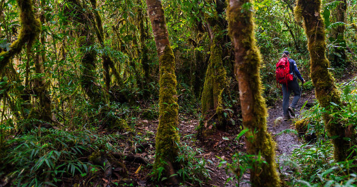
Two days later, equipped with all the gear and coca leaves that should last for a couple of days we begin our march and pass the Puca Pucara ruins situated outside Cusco. Along comes Eddy — our translator, Richard and Edwin. The last man is responsible for our animals: three horses and a mule. The goal? To reach Machu Picchu by Qhapaq Ñan, ancient Inca trails, that irreversibly changed the landscape of the South American continent. The length of those routes adds up to 25 thousand kilometres, and their scope stretches from the territory of the modern-day Columbia to central Argentina. The most rapid development of Qhapaq Ñan took place during the reign of Pachacuti Inca Yupanqui, the ninth emperor of Tawantinsuyu — which in Quechua means: “The Four Regions Land”. The routes began in the capital of Inca Empire, Cusco. Then they led through various lands — tropical Amazon rain forests, deserts, but most of all, valleys and steep slopes of the Andes. They were also many different kinds of them — wide roads built for administrative purposes were suitable for large llama caravans, narrow trails with ritual significance were provided with water canals, the numerous switchback stairways would often lead high up to mountain ridges above 5000 metres above sea level. Apart from the main roads there was also a dense network of minor paths that played the role of connectors. Those paths were used by chasquis, the messengers whose task was to deliver the messages both verbally and through the knot system called qhipu.
How was it possible, that the Incas, who did not even know the invention of the wheel, were able to subject all the other cultures and create one of the biggest human engineering accomplishments? I address this question to an archaeologist, Oscar Montufar La Torre, the coordinator in Ollantaytambo archaeological site, and his answer is this: “With hard work of many generations within the Mit’a system. Every village would delegate men and women who for a certain time would perform public service according to the current demand. The Incas were incredibly hard-working people which is reflected in, among other things, their symbolic moral code: ama suwa, ama llulla, ama qhella — that literally translates to: do not steal, do not lie and do not be lazy”. It is partially due to Oscar’s efforts and hard work, comprising excavation, cleaning and meticulous documentation of kilometres of roads, that in 2014 the Qhapaq Ñan became the UNESCO World Heritage Site. Getting to Ollantaytambo took us three days of intensive march through high mountain-passes, Inca ruins and farmlands. This is where Richards tells his story.
I take a small portion of llipta — a black mass made from a mixture of ash, quinoa and cocoa and along with a dozen of coca leaves I form a kind of a small lump. I put it in my mouth between the cheek and teeth and start chewing on it. From now on, every step of the way is easier to take than the previous one, and the backpacks seem to weigh less and less with every passing minute — leaves contain alkaloids that make marching less arduous, even on the altitude way above 4000 m a.s.l. Erythroxylum coca, commonly known as coca, has for centuries been a sacred plant to the dwellers of Andean villages. When chewed, it soothes the hunger and increases resistance to cold and fatigue. When I finally reach the ridge, I glance backwards, but can’t quite see the road that led me here. There is something fascinating about the paths we follow — until I brush away the dense knee-high ichu grass they are invisible to the eye. It’s the grass that made it impossible to find the paths on satellite photos when we were trying to make preparations for the trip. But they are here. I stand on the Inca Chiriasca pass and I get the feeling that this is the kind of expedition that you read about in books, wishing for your dreams to come true. None of the Inca roads that we passed to get to the sacred mountain of Salkantay have been in any way catalogued or described. Unbelievable.
Richard snaps me out of my contemplation when he points to a spot near the foot of a great pyramid built of ice and rock. “When I came to this ridge for the first time the glacier stretched up to there. It was 17 years ago”. The difference is shocking. The spot arriero was pointing to was about 200 metres away from the current position of glacier ridge with nothing between but drab, brown rocks. Not the colour is the issue here, though, it’s the consequence.
According to the United Nations Framework Convention on Climate Change (October 2014) 70% of tropical glaciers are on the territory of Peru, and over the past 40 years their stretch has shrunk by more than 40%.
What is more, during that time over 1000 new glacier lakes were formed. What do those numbers mean to those who live in small Andean villages and who from generations have been making their living by farming? Degradation. End of tradition and family unity.
Estaqio Chaucca is 67-years old. We talk in a small village where he has lived his whole life. Much like his father, and grandfather.
“Here in Pucamrca we are all dependent on potatoes. Merely 15-20 years ago the crops were the same in wet and dry season, we could water the farmland with water we took from lagoon of Sapato Cocha. Now, during the dry season, the potatoes are gone”.
Estaqio is a father of six. All of his children try to get by in cities — Calca, Urubambie, and the oldest daughters in Cusco. Smaller and smaller crops make it impossible to support traditional, large families. Many of the people living in the Andes do not know their date of birth — one of them is Hilaria Quispe. We meet her on the meadow near the road to Piuray Lagoon. Her life was better when her husband was alive. Unfortunately, he passed away 6 years ago. Every day before dawn she leaves her modest house in Tauca comunidad, and heads high up to the mountains to water her sheep. And every year she has to go higher and higher to find that water. During our trek we have many conversations that only confirm how big influence the melting of glaciers causing climate change has on the lives of people living here.
I take three leaves of coca and raise them towards the Salkantay in the way the citizens of the Andes have been doing it for centuries, offering sacrifices to the gods. My head is full of grateful thoughts — at this moment we are standing on the highest point of our road. The wind snatches the leaves, blows them up in the air and almost immediately the Salkantay is covered by dense, dark thunderclouds. It’s time to go — we start to walk down towards the selva.
Swirling cicadas make my senses go crazy. The noise is so bewildering as if the insects were trying to drown out the sound of rumbling waters of the Urubamba river flowing nearby. We march after dark, along the rail-road leading to Aguas Calientes — small town, the last stop before Machu Picchu. I voraciously breathe in a large draught of humid, tropical air. Over the past two days we’ve been changing the climate zone with every step of the way. Tedious landscape of rocks and grass has smoothly transformed into coffee, pawpaw and passion fruit plantations. The soothing concert of the insects is brutally stopped by the incoming train. We manage to jump out of its path almost in the last second.
Now, when we travel without the assists of arrieros, I realise how important pieces in this expedition puzzle are people. Their genuine devotion, knowledge of mountains and sense of humour are what I will always miss, with maybe the exception of a small portable radio hanging on Edwin’s arm invariably playing the jumpy huyano music broadcast by Radio Inti Raymi. Having marched for 200 kilometres in ten days — in the sun, in the rain, in the hail and gusty winds, we finally make it. The lost city of the Incas — Machu Picchu. 100 years ago, its discoverer, Hiram Bingham, wrote the following words: “In the distance, as far as we could see, a maze of hills, valleys, tropical jungle, and snow peaks held the imagination as though by a spell. Such were our rewards as we lay panting by the side of the little path when we had reached its highest point.” Despite the years that have passed those words are still valid.
With many thanks to: Eddy, Richard and Edwin from PumaPath.com
Expedition was supported by: Victorinox, Rab, Lenovo and National Geographic
Text: Mateusz Waligóra / Photos: Michał Dzikowski
703views
Share on Facebook


 No fees, cancel anytime


21
0