Get Premium
Dark mode theme is available exclusively for premium users. Learn more about the benefits of subscribing.
No fees, cancel anytime.

 Dark Mode Ad-Free Browsing Unlimited Content
 Ad-Free Browsing Unlimited Content Dark Mode
Join 1.2 million Panda readers who get the best art, memes, and fun stories every week!
After months of work I’ve finally finished the world’s first ever global ocean drainage basin map that shows all water flows on the planet. Continents, countries and states are also part of this new portfolio, sometimes with quite surprising results. Did you know that half of Minnesota’s rivers end up in the Arctic Ocean? Well, me neither, and I am a geographer.
My name is Robert, a GIS analyst, and I run my little mappy business called Grasshopper Geography. You might have seen my colourful river basin maps before, they’ve been around since 2016. When I created them they became such a hit that I eventually decided to leave my nine-to-five job behind to try and make a living from my new passion. Since then, my artistic watershed maps have been featured on the pages of more than a hundred newspapers and news sites. Being the prime example of an introvert, I never thought that anyone would be interested in my little projects, so this was a really humbling experience that I still couldn’t get over completely.
I regularly work together with NGOs from all around the world who fight for important environmental causes. I really hope that these new maps will also be able to help convey their messages, may it be about river pollution or just a visual reminder of our interconnectedness.
I know from experience that maps can be great conversation starters, and I aim to make maps that are visually striking and can effectively deliver a message. With these ocean drainage basin maps the most important part was to make them easily understandable, so after you have seen one, the others all become effortless to interpret as well. Let me know how I did, I really appreciate any and all kinds of feedback.
You can read more about Grasshopper Geography’s mission and see all my maps on my website. Drop in anytime to say hi!
More info: grasshoppergeography.com
An endorheic basin is one which never reaches the ocean, mostly because they dry out in desert areas or end up in lakes with no outflow. The biggest endorheic basin is the Caspian’s, but the area of the Great Basin in the US is also a good example of endorheic basins.
Most of the new maps have four versions: I made them with black or white background, with coloured oceans (aka polygons) or without. I still have to decide if I like this version more than the one above. What do you think?
I know these two colours weren’t the best choice for colourblind people and I apologize for that. I’ve been planning to make colourblind-friendly versions of my maps for ages now – not sure when I get there, but I want you to know that it’s just moved up on my todo-list.
And here’s Minnesota. Crazy with all that blue, right? Some other US states that are equally mind-blowing: North Dakota, New Mexico, Colorado, Wyoming. You can check them all out on my website.
Look at all those small endorheic basins!
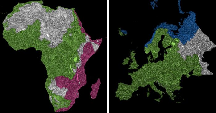
The greatest surprise with Europe is that its biggest river is all grey, as the Volga flows into the Caspian sea.
Iceland is just half ‘n’ half.
I love how the green of the Atlantic Ocean tangles together in the middle.
No, the dividing line is not at Cape Town, unfortunately.
Asia is amazingly colourful with lots of endorheic basins in the middle areas: deserts, the Himalayas and the Caspian see are to blame. Also note how the Indonesian islands of Java and Sumatra are divided. (See them separately on my website.)
I mentioned earlier that I also made white versions of all maps. Here’s North America with coloured oceans. I think it looks neat.
Yes, most of the Peruvian waters drain into the Atlantic Ocean. (There are maps of Peru on my website, if you want to take a closer look.)
Australia with all its vast deserts. If you wonder about the weird lines in the middle: that’s the Simpson desert with its famous parallel sand dunes.
Finally, I made drainage basin maps of the individual oceans: The Atlantic, the Arctic, the Indian and the Pacific. Check them all out at grasshoppergeography.com and let me know what you think!
Thanks for stopping by and reading it all through. And if you know anyone who’d be interested to see these maps, share this article with them to help an independent artist keep his small business afloat!
476views
Share on Facebook


 No fees, cancel anytime


18
0