Get Premium
Dark mode theme is available exclusively for premium users. Learn more about the benefits of subscribing.
No fees, cancel anytime.

 Dark Mode Ad-Free Browsing Unlimited Content
 Ad-Free Browsing Unlimited Content Dark Mode
Join 1.2 million Panda readers who get the best art, memes, and fun stories every week!
For most people, Google Maps is a simple tool used to find directions or check what a place looks like before visiting. But beyond helping users map their travels, the same satellite images and Street View cameras have become a powerful tool for law enforcement.
Over the years, investigators, journalists, and even ordinary internet users have uncovered clues hidden in Google’s vast collection of images, helping solve cases that once seemed impossible.
In some cases, a passing Street View car captured a suspect moments before or after a crime. In others, satellite imagery revealed missing vehicles, hidden evidence, locations that helped authorities narrow down a search, and even the bodies of long-lost loved ones.
From cold cases solved decades later to fugitives exposed by a single photograph, these digital snapshots have sometimes played a surprising role in real-world investigations.
Here are 15 times Google Maps helped uncover crimes, identify suspects, or bring long-standing mysteries closer to the truth.
This post may include affiliate links.
In November 2020, 83-year-old Paulette Landrieux, who was living with Alzheimer’s, vanished from her home in Andenne, Belgium, in a matter of minutes.
Her husband, Marcel, had stepped outside to hang laundry while she watched television. At some point, Paulette walked out of the house, passed right by him without him noticing, crossed the street, and disappeared. When he returned inside and realized she was gone, panic set in.
The neighborhood mobilized that same day, and police searched the surrounding area with dogs, focusing on nearby roads, wooded patches, and open land. Despite the scale of the effort, there was no trace of her.
As time passed, the case stalled. Months turned into years without a single solid lead explaining where she had gone after crossing the street.
The breakthrough came almost two years later, when a neighbor happened to be browsing Google Maps and clicked through Street View images of the area. In a photo taken on the very day Paulette vanished, captured by the passing Google Street Car, she appeared in the background walking along a nearby road.
That frozen frame provided investigators with a confirmed direction of travel.
Using the exact location visible in the Street View image, authorities concentrated their search along that route.
Not far from where she had been photographed, they found her skeletal remains inside dense, dry brush on a slope. Investigators concluded she likely slipped down the embankment, became tangled in brambles, and, unable to climb back out, passed away there.
In October 2006, 72-year-old Davie Lee Niles disappeared after leaving a bar in Byron Township, near Grand Rapids, Michigan.
Niles, who had been dealing with cancer and depression, was last seen on October 11. When he failed to return home, he was reported missing, and a search was launched, but investigators were unable to find any trace of him or his vehicle.
In November 2015, an employee at a nearby funeral home was decorating a Christmas tree using a lift when he noticed something unusual in a nearby pond. From the elevated position, he could see what looked like the roof of a car just beneath the water’s surface. He called the police, who sent divers to investigate.
When authorities pulled the vehicle from the pond, they found skeletal remains in the driver’s seat. The car was registered to Niles, and his wallet was discovered inside. Investigators later said the remains were believed to be his, bringing long-awaited closure to his family.
The discovery revealed another detail: the submerged car had been visible in satellite imagery of the pond for years. Images available on Google Maps showed the outline of the vehicle in the water, though no one had recognized it until the real-world discovery drew attention to it.
Authorities said the pond where the car was found sits roughly half a mile from the bar where Niles was last seen. Investigators did not suspect foul play, though they could not determine exactly how the car ended up in the water.
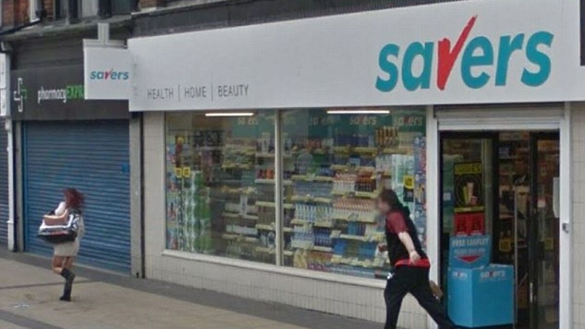
In 2014, a routine pass by a Google Street View car captured the moment a shoplifting incident unfolded outside a discount store in Middlesbrough, England.
The images showed Tammy McIvor, then 30, running out of a Savers shop carrying a Sports Direct bag filled with about £60 ($80) worth of stolen items. In the photographs, a store employee can be seen chasing her down the street.
The images might have gone unnoticed if not for Peter Darby, an IT worker who was browsing Google Street View to look at areas around his former university. While navigating through the street images, he noticed the unusual sequence: a woman running from the shop, followed by a man apparently pursuing her.
Darby alerted the store, which then examined the images more closely.
Store staff were able to identify McIvor based on her clothing, including the white top she was wearing during the incident. When police later arrested her, she was reportedly wearing the same outfit.
McIvor later pleaded guilty to theft at Teesside Magistrates’ Court. She received a 12-month community order that included drug rehabilitation requirements. Court proceedings also noted that she had a long history of substance dependence and previous theft-related offenses.
Between 2015 and 2019, Benjamin Frederick Moran repeatedly exposed himself and performed lewd acts in public locations across Brisbane, Australia.
Police later said the 44-year-old security guard targeted areas with regular pedestrian traffic, including bus stops and suburban streets in Windsor and Annerley.
Court documents show Moran admitted to 33 indecent acts during that four-year period.
According to prosecutors, he often hid behind trees, bushes, or construction barriers and waited for women walking alone before revealing himself.
One of Moran’s offenses was unexpectedly captured by a Google Street View camera as the mapping vehicle passed through the area. The image showed him engaged in the act on a public street.
In January 2019, a woman contacted police after seeing Moran on Truro Street in Windsor. Officers quickly located him nearby.
During questioning, Moran confessed and used a map to show investigators multiple locations where he had carried out the acts. Police then cross-referenced those locations with earlier reports.
The admissions resulted in 23 charges of indecent acts, with 10 additional offenses considered during sentencing.
In 2019, the Brisbane Magistrates Court sentenced Moran to six months in prison for each of the 23 charges, with the sentences suspended for two years. He was also placed on probation for the remaining offenses.
Psychological reports presented in court said Moran suffered from exhibitionistic disorder.
In July 2010, two men were fatally wounded during a gathering in Richland County, South Carolina.
The victims were identified as Edgar Lopez and Pablo Gutierrez-Guzman. Witnesses told investigators that an argument had broken out shortly before the attack and identified Leslie Todd Parvin, an Army veteran, as the suspect.
After using his firearm, Parvin disappeared. Witnesses reported that he had been driving a green Kia minivan, and one person was able to provide investigators with part of the vehicle’s license plate number.
Detectives began tracing vehicle records connected to that partial plate. During the search, they found an address believed to be associated with Parvin. Before sending officers out, investigators checked the property using satellite imagery on Google Maps.
In the driveway, they saw a green minivan matching the description given by witnesses.
The image confirmed that the vehicle linked to the suspect was located at the property, helping investigators focus their search. Authorities soon moved in, and Parvin was arrested in August 2010.
He was later charged in connection with the homicide of Lopez and Gutierrez-Guzman.
In this case, Google Maps did not capture the crime itself. Instead, satellite imagery helped investigators confirm the presence of a key vehicle linked to the suspect, narrowing down the location where police ultimately found him.
In November 1997, 40-year-old William Moldt disappeared after leaving a nightclub in Lantana, Florida. He called his girlfriend around 9:30 p.m. to say he would be home soon, but he never arrived. Police opened a missing-person investigation, yet no clear leads emerged, and the case eventually went cold.
More than two decades later, the answer was sitting in plain sight.
In August 2019, a former resident of a neighborhood in Wellington, Florida, noticed something unusual while looking at satellite images of the area online. In a pond near Moon Bay Circle, the outline of a vehicle appeared clearly visible in the water. The former resident contacted someone who still lived nearby and suggested they check the pond.
Using a drone, the resident confirmed that a submerged car was visible beneath the surface and alerted authorities. When police pulled the vehicle from the pond, they found skeletal remains inside.
A week later, those remains were identified as William Moldt.
Investigators concluded that Moldt had likely lost control of his vehicle the night he disappeared and driven into the pond. According to the Palm Beach County Sheriff’s Office, the car had been visible in satellite imagery for years.
A report from the missing persons database, the Charley Project, later noted the vehicle could be seen in aerial images dating back to 2007, though no one had recognized it until 2019.
In 2010, police dismantled a her*in trafficking ring operating in East Williamsburg, Brooklyn, after months of complaints from residents about open drug sales near Jackson Street and Kingsland Avenue.
The investigation was led by the NYPD and the Office of the Special Narcotics Prosecutor. Undercover officers posed as customers and conducted more than 20 controlled purchases of substances as part of the operation.
The items were typically sold in $10 glassine envelopes stamped with brand names such as “FedEx,” “KFC,” and “Powerful Impact.”
During the investigation, authorities noticed that Google Street View images of the intersection showed several of the suspects standing outside the same bodega where the drug sales regularly took place.
The images captured Shaundell Dade, Jamel Pringle, and Jonathan Paulino gathered at the corner that investigators already believed was a dealing location.
In November 2010, police arrested seven members of the ring and charged them with multiple counts of criminal sale of a controlled substance.
Authorities also uncovered how the dealers hid the items nearby: packets were stored inside a magnetic lockbox concealed behind a metal storefront sign at the Neighborhood Grocery.
For nearly two decades, Gioacchino Gammino, a convicted Italian mafia member linked to the Sicilian criminal group Stidda, lived quietly under an assumed identity in Spain.
Gammino had escaped from a Rome prison in 2002 while serving a life sentence for murder and mafia-related crimes. After disappearing, he resurfaced years later in Galapagar, near Madrid, using the name “Manuel.”
Italian authorities believed he was in Spain but lacked a confirmed location.
The breakthrough came through open-source investigation. While reviewing Google Street View imagery in Galapagar, investigators spotted a man outside a grocery shop called El Huerto de Manu who resembled Gammino. The image alone was not enough proof, but it gave them a specific area to examine.
Further checks led authorities to a nearby restaurant, Cocina de Manu, which featured Sicilian dishes. Photos associated with the business showed a man in chef’s attire matching Gammino’s appearance. A visible scar on his chin helped confirm the identification.
Spanish police arrested Gammino in December 2021.
Following his capture, Italian media reported that he expressed surprise at how he had been located after so many years without contact with family. He was subsequently extradited to Italy to serve the remainder of his life sentence.
In Tajueco, a tiny hamlet in Spain’s Soria province, a Cuban man disappeared in November 2023.
The case began when someone close to him reported him missing after receiving odd messages from his phone claiming he had met a woman, was leaving Soria, and was ditching the phone.
Investigators did not buy the story, and the inquiry started aiming toward the people around him.
A year later, a Google Street View car happened to pass through Tajueco for the first time in roughly 15 years.
In the October 2024 Street View sequence, there was a frame that appeared to show a man leaning into the trunk of a red car beside bulky white bags. Another Street View image from the village shows a person moving a large white bundle in a wheelbarrow.
Spanish police later arrested Manuel Isla Gallardo, 48, and his partner, Alicia. The investigation revealed the couple took the life of the missing Cuban man, identified as 33-year-old Yoel, after a dispute.
The white bags detected by Street View contained Yoel’s dismembered body. His remains were later found buried in a shallow grave at the Tajueco cemetery. The couple was charged with illegal detention and homicide.
In January 2009, nine-year-old Natalie Maltais went to spend the weekend with her grandmother, Rose Maltais, in Athol, Massachusetts. Instead of returning home, Natalie was taken out of state.
Authorities later said Rose told her daughter they would “never see her again,” and a kidnapping warrant was issued.
Investigators quickly realized Natalie’s cell phone was the key. The device continued to generate GPS data as Rose drove south, allowing police to track their movement. Eventually, the signal placed them near Route 11 in Natural Bridge, Virginia.
The coordinates were useful but imprecise, narrowing the search to a radius of roughly 165 feet. Along that stretch of highway, that still meant multiple possible locations.
That’s when Google Maps became part of the investigation.
Using the GPS data, Deputy Fire Chief Thomas Lozier pulled up Google Street View and began virtually scanning the area along Route 11. By moving frame by frame through the imagery, he identified a red-roofed roadside motel that matched the location indicated by the last phone ping: the Budget Inn.
Virginia State Police were alerted to the specific property. Within hours, officers located Natalie and Rose inside a room at the motel. Natalie was unharmed. Rose was arrested on kidnapping charges.
In July 2011, a woman in Oklahoma City returned home to find two armed men inside her house. According to local reporting, the intruders held her at gunpoint for more than an hour while they searched the property and stole belongings before leaving.
Despite several clues left at the scene, investigators were unable to identify the suspects at the time.
In 2014, the victim’s friend was browsing the neighborhood on Google Maps when she noticed something unusual in a Street View image taken around the time of the robbery.
The photo showed two men walking directly in front of the victim’s home. Their faces were blurred by Google’s privacy filters, but their clothing matched the description the victim had given police.
The friend sent the image to the victim, who immediately believed the men in the photo were the same individuals who had robbed her house. The Street View image had been captured in the same month the crime occurred, suggesting the Google camera car had passed by the property at nearly the exact moment the suspects were outside.
The discovery gave investigators their first new lead in the case in years. The victim said she hoped someone might recognize the suspects from the image and contact police.
In 2022, police in Oxford, England, discovered one of the largest suspected bicycle theft hoards the area had ever seen. More than 500 bicycles were recovered from the backyard of a property in Littlemore, a suburb south of the city.
The collection had grown so large that it could be seen clearly from above. Satellite imagery on Google Earth showed a massive pile of bikes filling the garden behind the house, something neighbors said had been building up for years.
Following an investigation and multiple complaints from residents, Thames Valley Police executed a search warrant at the address.
Officers recovered hundreds of bicycles believed to be stolen and arrested a 54-year-old Oxford man on suspicion of handling stolen goods and possessing criminal property. His name was not disclosed.
Authorities then faced the difficult task of identifying the rightful owners of the bikes, many of which had likely been stolen over several years. Police said they were working through the recovered property to match bicycles with theft reports.
In September 2008, a 14‑year‑old boy in Groningen, the Netherlands, told police that two men had dragged him off his bicycle on Merwedestraat and stolen 165 euros and his mobile phone.
Months later, in March 2009, he was browsing Google Street View at home when he saw something startling: an image of himself riding his bike with two men walking directly behind him, taken just before the robbery.
Because Google’s service automatically blurs faces, Dutch prosecutors formally asked the company for the original, unblurred photograph, arguing that it could help them solve the crime.
Google complied, and when investigators examined the clear image, a robbery‑squad detective recognized one of the men as someone already known to police, who also happened to be a twin; that led them to identify his brother as the second suspect.
Police arrested the 24‑year‑old twin brothers on suspicion of robbery, marking what Groningen authorities described as the first use of Google Street View imagery in a Dutch criminal investigation.
The brothers admitted they were the individuals in the photograph but denied robbing the boy, and local reporting mentioned that one brother confessed to several other offenses involving money.
In the early 2000s, a Cortina d'Ampezzo real-estate entrepreneur declared zero income for 2001, but the Italian Guardia di Finanza soon uncovered a trail leading to Sardinia, an island in the Mediterranean Sea.
In 2002, the entrepreneur had sold a Porto Rotondo villa, complete with a swimming pool described by officers as "phallic," for just €280,000 ($325,276), surprisingly cheap for one of Europe's priciest coastal enclaves.
Suspicious, officers fired up Google Earth, scanned the luxury enclave for the pool's unique shape, and pinpointed the property.
Comparing the satellite view to cadastral records revealed the villa's real value neared €1 million ($1,161,700), revealing a blatant undervaluation in dodge taxes.
That breakthrough led to a full financial audit, exposing hidden bank accounts stuffed with undeclared cash.
By the end, the entrepreneur and his brother faced charges for evading roughly €7 million ($8 million) in taxes.
The identities of the entrepreneur and his brother have not been disclosed by local media.
Police in southern Oregon say a view from space helped them spot a medical marijuana grow that had quietly tripled its legal limit.
After getting a tip that 50‑year‑old Curtis W. Croft was boasting about his plants, investigators from the Rogue Area Dr*g Enforcement team pulled up his rural Josephine County property on Google Earth and saw neat rows of cannabis in his outdoor garden.
The Google images, captured in June 2013, showed far more than the 30 mature plants Croft was allowed to grow as a registered medical‑marijuana provider for five patients, so officers flew an aircraft over the site and checked Oregon’s registry to confirm the numbers.
When they raided the property in September, they counted 94 plants and seized the garden.
Croft was arraigned in Josephine County Circuit Court on charges including unlawful manufacture and sale of marijuana and was released pending further proceedings; public reports do not show how his case ultimately ended.
It was one of several early examples of police using freely available satellite imagery to target cannabis farms, following a 2008 Swiss case in which officers using Google Earth to locate two suspects’ farms accidentally discovered a two‑acre marijuana field hidden inside a cornfield, leading to multiple arrests and large seizures.


 No fees, cancel anytime


")
")


