Get Premium
Dark mode theme is available exclusively for premium users. Learn more about the benefits of subscribing.
No fees, cancel anytime.

 Dark Mode Ad-Free Browsing Unlimited Content
 Ad-Free Browsing Unlimited Content Dark Mode
Join 1.2 million Panda readers who get the best art, memes, and fun stories every week!
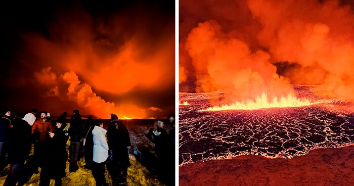
Jaw-dropping footage of a massive volcanic eruption in Iceland was captured by various thrill-seekers, defying the hazardous bubbling lava and smoke spewing into the sky.
Dramatically erupting on Monday (December 18) on the Reykjanes peninsula, astonishing bursts of volcanic matter started to illuminate the night sky at around 10 p.m. local time, following weeks of seismic activity that prompted the evacuation of a nearby town.
The Icelandic Meteorological Office reported that the eruption was located close to Hagafell, about three kilometers (about two miles) north of the town of Grindavík, where around 4,000 people live.
Image credits: Micah Garen/Getty Images
Image credits: Aberdeen Guardian
In a statement Tuesday (December 19), Iceland’s government informed the public that the fissure opening in the ground where lava emerged from was almost four kilometers long.
It is the fourth eruption in the area since 2021 and the biggest so far, the statement further revealed.
Last month, an evacuation order was issued for Grindavík and nearby communities, preventing residents from staying in their homes overnight as the threat of a volcanic eruption loomed, public broadcaster RÚV reported.
Citing the police, Grindavík, which was previously feared to be in the path of flowing lava, is now clear of residents, RÚV reported.
Moreover, the eruption has reportedly been deemed to not be life-threatening, Iceland’s government said in its statement. But the area remains closed to all traffic, while strongly warning people not to approach the area, the statement added.
Image credits: Icelandic Meteorological office
Image credits: Aberdeen Guardian
Despite lava no longer being expected to reach Grindavík, it is reportedly releasing “considerable” toxic gases, as per the Icelandic Tourist Board on Tuesday. It said: “People are strongly advised against visiting the site of the eruption while responders and scientists assess the situation.”
It added that the eruption is classified as a fissure eruption, which does not usually result in large explosions or significant production of ash dispersed into the stratosphere, CNN reported.
Some people defied the warnings and were able to venture near the eruption, taking astonishing pictures of Iceland’s black night sky lit up a deep orange color.
One photograph captured the Reykjanesbraut, a key Icelandic highway in the area, lit up with white headlights from cars traveling towards the crater, the Daily Mail reported.
Large crowds continued to gather on vantage points to look at the lava spurts illuminating the sky, despite multiple warnings from Icelandic authorities.
Under normal circumstances, Grindavík is best known as a popular place for tourists because it lies some seven kilometers from the famous Blue Lagoon geothermal spa.
Image credits: Aberdeen Guardian
Image credits: Aberdeen Guardian
In the first two hours of the eruption, hundreds of cubic meters of lava were being released per second, according to the Icelandic Meteorological Office. But the eruption’s intensity, and the level of seismic activity in the area, had decreased by early Tuesday, with lava spreading laterally from either side of the newly opened fissures, as per CNN.
According to the broadcaster, the intense wave of hundreds of earthquakes last month sparked a national state of emergency after the country’s Civil Protection Agency reported a magma tunnel was forming that could reach Grindavík.
Image credits: Aberdeen Guardian
Image credits: Ólöf Ögn Ólafsdóttir
At the time, the agency said: “It is clear that we are dealing with events that we Icelanders have not experienced before, at least not since the eruption in Vestmannaeyjar,” referencing a 1973 eruption that began without warning and destroyed 400 homes.
Iceland sits on a tectonic plate boundary that continually splits apart, pushing North America and Eurasia away from each other along the line of the Mid-Atlantic Ridge. It is home to 32 active volcanoes, the broadcaster reported.
Image credits: Ólöf Ögn Ólafsdóttir
Image credits: Icelandic Meteorological office
As a result, Iceland is acclimatized to volcanic eruptions. The Bárðarbunga volcanic system situated in the center of the country erupted in 2014, producing lava that covered 84 square kilometers (32 square miles) of highland but didn’t damage any communities, as per CNN.
Experts do not forecast a volcanic eruption to cause the same level of chaos as that seen in 2010 when the Eyjafjallajökull volcano erupted, since it is unlikely to involve the glacial ice that led to a huge ash cloud.
In 2010, around 100,000 flights were canceled, affecting 2 million people, as a result of the ash spewed out by the eruption, which threatened to stall aircraft engines and cause electrical failure, according to the broadcaster.
Lionel Wilson, Emeritus Professor of Earth & Planetary Sciences at Lancaster University, told CNN last month: “Eyjafjallajökull involved an eruption through or next to glacial ice that melted and provided water that made the eruption more explosive than it would otherwise have been, hence the high eruption plume and very wide ash dispersal.”
1k+views
Share on FacebookIf there's a place l wouldn't go to rn that's Iceland. But then again, l'm the kind of tourist who avoids natural disasters 🤷🏻♀️
Gotta admit it would be cool to be above from a safe distance in a helicopter..still dangerous but the experience of a life time I bet
If there's a place l wouldn't go to rn that's Iceland. But then again, l'm the kind of tourist who avoids natural disasters 🤷🏻♀️
Gotta admit it would be cool to be above from a safe distance in a helicopter..still dangerous but the experience of a life time I bet


 No fees, cancel anytime


45
7