Maps can look absolutely incredible, but they require a lot of focus and dedicated effort. Whether you’re an artist, adventurer, geographer, engineer, statistician, or just a fan of good design, quality cartography can bring you a whole lot of joy.
The ‘Epic Maps’ account on X (formerly Twitter) is a fabulous project that celebrates great examples of cartography. Many of these designs are unique, creative, and unusual, so we wanted to share the very best ones with you, dear Pandas. Scroll down for a look, and don’t forget to upvote your favorite ones!
More info: X | Instagram | YouTube | Newsletter
This post may include affiliate links.
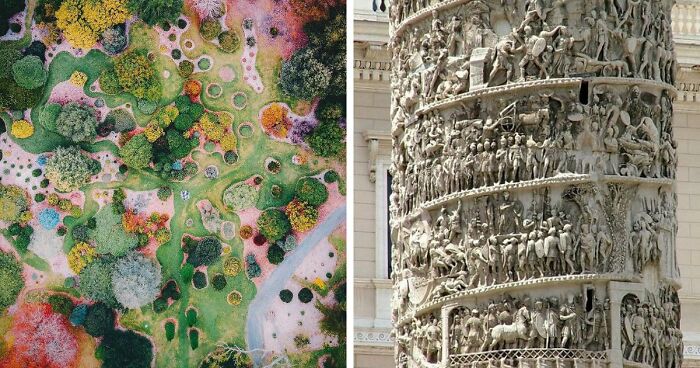
The Earth may not be a perfectly round sphere for space football, but it would be an amazing sensory widget for stimming. What I mean is, I want to touch this map.
I heard that if you shrunk earth to the size of a snooker ball, it would feel smoother than the ball!
Load More Replies...The formidable Andes. Amazing that the rugby team (the ones famous for cannibalism) were able to get out at all. I really recommend the podcast You're Wrong About for learning more about their ordeal. It's an amazing story and testament to the human spirit.
The Andes? Aren't they at the end of the Wristies? ;-)
Load More Replies...The curator of ‘Epic Maps’ states that their goal is to share “educational and informative” world maps. This hasn’t changed over the years since the account was created in December 2020.
Currently, around a million X users follow the project on the social network. The curator also has a weekly newsletter you subscribe to and runs a YouTube channel, as well as an Instagram account.
I wish we learned in school that the Mercator projection and the actual size/shape of the Earth's landmasses are often wildly different
We learned that early, but that's because we were in south Africa, and it's not one eighth the size of Greenland, which is how it appears on Mercator. Mrs Moorhouse soon sorted that one out.
Load More Replies...So you can fit countries on a continent? Wow! I never would have expected that. 🤔
Not illustrated here is the fact that most of South America lies east of North America.
Ok but all due respect Canada isn't there. I believe, but could be wrong, that you could jigsaw Canada into this rather than the European countries so... both North America and and South America are about the same size right? Which means I'm really confused what this is trying to tell me. Two continents are very large?
(I grew up in Japan btw) and I didn't even know that South America existed till I was about 12
The saddest space picture. A picture of a normal country next to a prison.
But just for the wildife. As a human, you don't wanna live there ....
Load More Replies...https://www.snopes.com/fact-check/rome-map-roads/ Fact checked by Snopes - short version, not real.
To bad they had really shįty cookies opt-out options.. like not at all real?
Load More Replies...There is no road from the UK to the continent. You can't drive down the Eurotunnel- have to load your car onto Le Shuttle train
I didn't know that there was a road to Ireland.
Load More Replies...From this picture I'd say all roads lead to Florence, with a branch line to Rome...
But more seriously, this map is meaningless without saying how it was compiled. You can make all roads lead anywhere if you take the right turnings - after all, it's not like you end up in Rome every time you leave the house, is it?
Load More Replies...Rome established and maintained the first roads. With slaves btw. All roads lead FROM Rome.
The difference between great maps and subpar ones lies in the balance between function and form. Obviously, a proper map needs to provide some sort of relevant and practical information for the user. It needs to be detailed enough to be useful, but not overwhelmingly so to the point of confusion.
Visual clarity is massively important, from the fonts and symbols you use to the overall aesthetic. Deciding not to feature certain information can be just as important as what you do decide to showcase. Simplicity is key. Clutter is bad (unless it’s extremely aesthetic and intentional). The clearer and simpler a map is, the easier the information it features is understood, the better.
And matching rocks, and seafloor spreading rates and directions as determined by magnetic orientations of oceanic rocks. And radiometric dating.
I remember when this was pooh-poohed by the scientific establishment in the 1950s and have LOVED watching them get proven wrong again and again and again ever since.
Load More Replies...As a young student in elementary school, I pointed out to the teacher that the continents would fit together if the oceans weren't there. Oh my, that teacher said I was wrong and that the continents had always been separate. One more piece of information my generation was taught that has been proven wrong.
Same here! The teacher acted like I was crazy for saying they fit together.
Load More Replies...What if Cynognathus was just much smarter than we assume and had invented airplanes? They took the other guys for rides in them, too. (Yes, I know that this is not possible with all of the facts we know from many disciplines, I just like imagining wild scenarios as an exercise in creativity. I go on tangents like this. Maybe there's a fantasy story in there somewhere.)
I had a really nice childhood in Pangaea. (Gee, I must sound really old.)
Yet in the 50s and 60s we were taught that even tho the continents look like they fit together like a puzzle, that's just a coincidence.
Living in San Francisco for 48 years and I've seen lightning here less than 10 times.
I remember my California cousins visiting us in the Midwest one summer and being nervous about the possibility of a tornado. We were like, California has earthquakes, flooding, wildfires, but tornados are scary?
Load More Replies...Come to Orlando, Florida to Florida to experience the lightning capital of the United States.
I have lived in florida 34 years and for 10 of them I lived in Lakeland between Tampa and Orlando and I saw some wicked lightning strikes and loud thunder than anywhere else
What’s the reason for this phenomenon? I‘m totally flabbergasted, it never came to my mind that lightning aren’t more or less equally shared around the world. Born and still living in Germany, we have a couple of thunderstorms each year. Maybe 5-6 if I had to guess. Well I know, it’s partly influenced by geography, wind, temperature, air pressure etc. But not a single thunderstorm annually? That somewhat stunning.
I'm not a meteorologist, but I think air pressure and humidity have a lot to do with it
Load More Replies...I bet those gray areas don't get the same number of votes as the red. (USA, Electoral college.)
Half is still half, regardless of how much area it's spread over, so yes they do. Stop being brainwashed by revisionist nonsense.
Load More Replies...I'm not sure that would matter, half is half regardless of ethnicity - btw our indigenous population is only 4%
Load More Replies...A good-looking map that serves no actual purpose will be just that—a nice decoration. There’s nothing wrong with that, of course. Many people frame maps from fantasy and sci-fi worlds and give them a place of honor on their walls and shelves. You probably know some people who have detailed maps from The Lord of the Rings, The Witcher, and A Song of Ice and Fire at home.
Meanwhile, a map that is overwhelmingly functional and loaded with super-relevant info might help you with your job. However, if there’s no flow to the design and no clear aesthetic, it’s probably not something you’d be rushing to show off to others. Unless they’re in the same professional field as you are.
I looked at doing this back in 2019. The plan was to try and get to Japan without flying- you can get the ferry from Korea at the end. However I talked to someone who had done the Trans Siberian express and found it really dull and testing. Day after day of looking at pine trees drives you a bit mad, and I have some dietary issues so would worry about not being able to eat any food they sold. Might be good as a meditation or writing retreat! In the end I took the train from London to Bologna in Italy, visited a friend there, and then flew to Tokyo. This year I did my first sleeper train (London to Penzance) and really didn't enjoy it, so I think I made the right choice!
The trans Siberian is much comfier than the London - Penzance! The landscape is indeed monotonous but as you say it becomes meditative. We mostly did one day on one off to break it up and of course to see Russia. They also mostly don't serve you food on there. When the trains stop at stations it's for about 30 mins to an hour so you can stock up for the next stretch. I ate a lot of instant porridge. I think Russia would be tough with allergies though because the language barrier can be formidable!
Load More Replies...Came to just say that! Excellent underrated film
Load More Replies...The sleeper train from London to Penzance is great. The bed was comfy. You are meant to be asleep the whole way, so you get on in London, go to sleep and wake up in Penzance.
No wonder the man was stressed when he got back home and his dear wife Penelope told him she had moved the bed!
Load More Replies..."I got some oceanfront property in Arizona, from my front porch you can see the sea..." :)
Load More Replies...Not true unless you’re referring specifically to population. A large percentage of the population of the US would disappear as well.
Load More Replies...Some of those other countries are happier though 🤫 economy isn't everything
Yes, especially Belarus. Anyhow, this post was about GDP, not happiness.
Load More Replies...Does this mean Germany compared to all the highlighted countries added together?
And yet every winter there are homeless people here freezing to death. Yay capitalism.
For years there wasn't a winter with freezing grades, at least in South-Germany. The homeless people sleeping on the streets, whom II see regulary around are 100% beggers from other countries, who are refusing the Malteser help to go to a shelter. Sure, there are german beggers and punks on the street, but they don't sleep outside, not even in summer.
Load More Replies...Blend the two—good design and practicality—and you have the foundation for something that’s not only appealing to the eyes but also useful and informative. In our experience, the maps that tend to go the most viral are either incredibly unique looking or they blend an artistic look with some truly good information.
With so much content on the internet and especially on social media, even very educational maps probably won’t get as much attention as they deserve if they lack the aesthetic oomph. They simply wouldn’t be able to stand out from the crowd.
Not quite true. More like no cities, or big towns, in the green zones. But there are lots of little communities or farms in there.
It literally says "with no inhabitants living per square kilometre".
Load More Replies...It's mostly Forest and Mountains. Naturally the future North the warmer it is, with more population. The future South the colder and Snow and Ice. I live in the Auckland area, the largest city in NZ, and can still drive for about 40 minutes from home and shoot wild deer and feral pigs, and be home for tea.
I'm in Northland and 15 minutes drive to fish and or hunt. Dark sky every clear night for star gazing on my deck. Just over 5 million people in a country the size of the UK. We're so lucky.
Load More Replies...I live in the green zone, I'm pretty sure a few thousand other people do too 😆
It means there are less than one inhabitant per square kilometer in those areas. Probably less than one on a hundred kilometers in some places so mathematically it's zero.
All of Middle Earth was depicted by New Zealand. Except Mordor, that was Death Valley.
Africa is a continent, so why would it be in any way surprising that it should fit many countries in it? That's basically what a continent is, after all. (And yes, Europe is also a continent, but it's very small).
m.ore a demonstration of the bias of mercator projection maps
Load More Replies...So you can fit countries on a continent? Wow! I never would have expected that. 🤔
But.....Canada is the 2nd largest country on the planet.....also the longest shoreline on the planet. Canada...♥️👍👌
this fact stuck w/ me: at it widest, africa is wider than the distance from chicago, illinois to paris, france...and it's much longer!
Well, actually, it's an arc because the planet she is not flat she is a sphere. :)
Load More Replies...🎵 and as you travel round Cape Horn (heave away, haul away), you'll wish to Christ you'd never been born (we're bound for South Australia!) 🎵
Mercator maps are notoriously misleading. If you did this on a globe it would be a straight line.
There’s a ton of proof that the internet is madly in love with cartography (even if many people just like looking at cool and pretty pictures). ‘Epic Maps’ is far from the only project that brings the best and most interesting maps to the forefront of the internet.
There are many others, often boasting hundreds of thousands and even millions of dedicated fans. And there are lots of truly talented cartographers out there, both amateur and veteran alike.
For example, the founder of one globally famous cartography-oriented online community, Patrick who also works as a land surveyor, previously explained to us why people decide to make maps in the first place. According to him, there are many possible reasons.
Java has a population of 150 million. Indonesia has a population of 275 million.
For those on mobile and not familiar with Java, Java is highlighted yorange north-west of Australia
Javanese here. I'd say even the countryside is pretty densely populated. However the vilages are sparsely situated and there are vast paddy fields in between them. Or sometimes forest. I think the huge chunk of the population is in Jakarta. A good friend of mine studied in the State (in Maryland) and one of the things she found strikingly different was how huge the distance between one thing/location to another was. Probably because she lived in what you call the suburbs? Idk.
Because when explorers went West they needed more space to sell Steamed Ham
Load More Replies...“Sometimes for navigation, sometimes for showing statistical phenomena, and sometimes for fantasy. While artistic skill helps, it is not absolutely necessary,” he said. “The important thing is to make it easy for users to glean useful information. Most maps should have a thesis or a story it is going to tell and this needs to be told through the map.”
Many people feel inspired to go on more adventures in life after poring over a particularly good map. But that hype, energy, and motivation can fade once you start considering how tough it can be. You can get a tad overwhelmed. According to the land surveyor, there’s no alternative to seizing the day and following your dreams ASAP.
Nice joke! :) Please don't downvote me, but based on the characters below, it would be pronounced hay huh (black river), not hehe (haha).
Load More Replies...I learned only yesterday that all those cities pushing China’s industrialization and innovation are on the eastern side of the country. Talking about places like Shanghai, Shenzhen, Guangzhou, Beijing etc. The documentary was talking about the challenges they face after situating the world’s largest wind farm on the western edge on the country when the energy is most needed in the east.
The 6% section is what was crossed over in Journey to the West, so obviously people don't live there because it's absolutely chock full of demons.
Largely determined by which countries have bases in those areas, so they stick on the same time zone as their homeland.
I wish all of the countries that do not live close to the Antarctic, would bugger off and leave it alone.
Load More Replies...And now tell is how much cleaning they did until today in laos and cambodia....
Hey, but defense contractors made a lot of money, so that's a good thing, isn't it? Net positive? :-|
“I've noticed, especially as I've gotten older, that you only have so much time on this planet and every day that is wasted is a day that you'll never get back. If you want to get out and explore the world you just have to do it,” he told us earlier. “Some adventures will cost time and resources, but the real question I ask myself is can I afford not to do some goal I have my heart set on. There are so many opportunities in this world that it may be hard to choose, but if you wait too long those opportunities will be gone forever.”
They are super visible in Tukey and Greece though. Street cats everywhere.
I was a little surprised to see Turkey so low since they're known for liking cats.
Load More Replies...I need to move to Hungary asap and get 236 cats (I know, I know, it doesn’t mean 236 cats per person!)
I like your interpretation, maths are difficult:) I'm in France so I can get another 204 cats.
Load More Replies...Most people of Turkey are kind to kitties. Especially true for Istanbul.
People of the Netherlands! What's going on here? These are rookie numbers! We could, no we should do so much better. I implore you, rise up, go to your local pound, she those lovely cats there and ADOPT. Your live will be better!
Killing your neighbor's pets is rather illegal, and quite a bit psychopathic.
Load More Replies...This is a fascinating topic. There are several factors that mean in most of Europe more males.are born than females (distance from the equator being one); but differences in migration and life expectancy change that balance when you look at everyone.
Got more sheep than people here, and I'm pretty sure in the past 20 years women were 2 to 1 men.
Mostly that women live longer than men. The “extra” women in the pink countries are quite elderly.
Load More Replies...If you looked at the percentages rather then one over the other, you'd note there really isn't much of a difference...
WWI & WWII, Spanish Civil War, War in the Balkans 1912 - 1913, others wars.
I didn't know this about Slovenia... Last I checked it was like 40% men and 60% women or maybe closer to 50/50
Yet people are still stunned to find their neighbors speaking Spanish in the used-to-be-green parts of the US.
Crikey ! I had no idea Mexico had so much land. Please forgive my ignorance ... I'm a dumb Aussie.
Meanwhile, the co-founder of another popular cartography-focused social media project, Erik, previously told Bored Panda that a map can be very powerful. “It is an effective way to communicate a phenomenon that has geographical or spatial relevance. From demonstrating the obvious of how neighboring countries see each other, to conveying complex information about the state of nature using remote sensing data," he said.
"In an ever-complex world, with apparently ever-complex challenges, from climate, nature, geopolitics, war, energy security, and human rights issues—maps enable us to understand and navigate the ever-evolving complexity of our societies.”
It was originally called the "IV League" because of football - Harvard, Yale, Princeton, and Dartmouth - that played together.
Sorry, not true. I was going to say that so I looked it up and it turns out to be an urban myth. Numerous schools celebrated the end of the school year with and Ivy Day when the students planted ivy on their campuses.
Load More Replies...From Wikipedia: "Origin of the name" following Map of the eight Ivy League Universities: "Planting the ivy" was a customary class day ceremony at many colleges in the 1800s. In 1893, an alumnus told The Harvard Crimson, "In 1850, class day was placed upon the University Calendar ... the custom of planting the ivy, while the ivy oration was delivered, arose about this time."[45] At Penn, graduating seniors started the custom of planting ivy at a university building each spring in 1873 and that practice was formally designated as "Ivy Day" in 1874.
Fun fact. Cornell is on the same campus with the State University of New York at Cornell. You can attend SUNY Cornell and sit in the same classes with people attending the Ivy League school.
Originally it was an athletic association of Pre-American Independence North East Universities, but later they the rules to allow Cornel to join after Rutgers rejected them. Rutgers was invited, because it pre-dated the American Revolution, but they rejected it, which is why they decided to change to allow Cornel to join, in that founding year so they would have 8 teams for a proper league.
Looks like a map of the Spanish missions in California. Each about a day's ride on horseback.
PLUS Wellesley, Smith, Mt. Holyoke, Radcliffe (now merged with Harvard), Barnard, Bryn Mawr
Why the downvotes? It's true. Jewish students are harassed, threatened and downright told that they should be killed. Harvard, MIT, Columbia, to name a few, are hotspots of anti-semitism. At least outside the USA they are no longer seen as the kind of university you should want to aspire to go to.
Load More Replies...Russia.....also a repressive communist dictatorship...(USSR) Nothing has changed since the 60s.
Right - so the region has had no economic and industrial development for the last 60+ years. Of course. No such thing as a Soviet-developed nuclear power station, everyone knows that. (https://en.wikipedia.org/wiki/RBMK and the rather safer https://en.wikipedia.org/wiki/VVER)
Load More Replies...Many social media content creators who share maps put in the effort to double-check at least some of the information featured in the images. They might do a general review of the data, but verifying every single tidbit can be quite impractical.
However, those people who actually end up making (and selling) their own maps go even further, using data and satellite data from trusted sources.
I'm sure more countries can be added since the toilet paper shortage of 2020-2022 from all those dummies who hoarded TP during the Covid-19 pandemic
Why did they take England off? Rude. (And don't say it's EU countries only, because Scotland and NI aren't EU and neither are some of the other countries here)
Why IKEA for sweden... they have thrir own flag... 🇸🇪... Sweden is other things than ålmhult and ikea...
Because it's a shitposting map. Netherland has as a favorite dish their *prime minister* Johan de Witt...
Load More Replies...Sorry, but why has England been missed out? If something as basic as Irish Stew qualifies, why not Lancashire hot pot, Cornish pasty, Shepherd's / Cottage pie, etc?
Parmigiana is actually from Neaples, not Sicily. Wienershnitzel was originally from Milan, later brought to Wien with the Austrian conquest of Lombardy. Paella is from Valencia, the map shows it on Barcelona. The Lechazo is from Castilla y Leon, it's mistakenly shown in Cantabria.
I was confused about paella too, because in Portugal we call it Arroz à Valenciana (Valencian Rice). Thanks for clearing that up.
Load More Replies...I like very much the Netherlands... this explains why so few PM visit it.
Stuffed cabbage marked for Romania as Sarmele are also very popular in Hungary, I know gulyás is the stereotip dish, but stuffed cabbage is also on the same level. There are evne regional variations of it. Some with tomatoes, some with sour cabbage, some with fresh spring cabbage ....
Somehow I feel like urban areas should be a bit larger. Or is this just counting large cities?
Which of these epic maps did you like the most, dear Pandas? Which ones surprised you with their content? Are there any that you’d actually consider printing out and hanging up at home?
Have you ever sat down and made a map for any reason? We’d like to hear your thoughts on everything. If you have a moment, share your opinion in the comments section at the bottom of this post.
Mmm. In the UK, it's illegal to collect wild flowers and other wild plants. Even picking up fallen sticks on the ground is technically theft. Whoever produced this map doesn't seem to have paid careful attention, although admittedly the UK does have more than two forests...
I don't disagree with most of the choices. I'm mostly just curious how each was chosen. What criteria was used to select the most 'iconic'?
The map of the United States would show the iconic artwork "Dogs Playing Poker".
Which countries besides Israel and Cyprus are Christians safe from persecution?
I don't know why (well, ignorance, of course) but I always thought of London as flat.
My dumb American brain saw "London" and "flat" in the same sentence and thought "apartment!"
Load More Replies...the fact people feel the need to flee their own country is sad. why cant we have a semi-peaceful world where you don't have to be scared in your own home?
Unfortunately, they are bringing a lot of the negative aspects of the countries they leave. It is an inevitability when no one is encouraged to assimilate. You cannot have mass numbers of completely opposite cultures living next to each other. You move to France-you learn French and adopt many of the customs of that culture. Remember, when in Rome...
Load More Replies...there are at least 10m in Türkiye. This number in the map is the registered ones
Wow. I had no idea that so many were so ill-educated. But it explains quite a lot, now I come to think about it. Now I want to see a correlation between education level and Trump supporters.
There's a big overlap on that Venn diagram, according to the polls.
Load More Replies...I am not an US american and too lazy to look it up, but is finishing high school mandatory in that green state (Wyoming?)?
I'm American and I'm a little surprised by it, as well. Also with California.
Load More Replies...That is what happens, when you make legal homeschooling for idiots. It makes sense why the orange clown could won his first election.
In increase in homeschooling is a direct result of what's been happening in education in the last 3.5 years.
Load More Replies...Be interesting to see that overlaid with voting data. I'm willing to bet that the more yellow an area is, the more red it is.
Doesn't mean anything. The quality of high-school education is dismal anyway
Yeah that's an interesting take, I guess it might be of worse quality than high school education in e.g. Europe
Load More Replies...Interesting article on Wikipedia about the number of Vietnamese settlers. Most were "Boat People" but some are descendants of North Vietnamese guest workers in the GDR. (this map looks very different than the one there which I've posted) Vietnamese...ed0a61.png
This will be the same in every single country within the near future.
True, although it's gonna be less Turks and more people from the Middle East and North Africa.
Load More Replies..."Gotta eat them all" 🎵 get your pasta bole today! 🍲
Load More Replies...So happy to see the chef kicking fettuccine alfredo away from Italy
What? How is this measured and how is the data collected? I call bullsh*t on some of the information shown on these maps.
On the side of the map, you can see the question they asked people. "Did you feel loved 'a lot' yesterday?" If they pulled random samples from every country and asked the same question of all of them (in their language, I assume), I don't see why it's any more b******t than any other survey of people's reported feelings.
Load More Replies...This is very ambiguous. Loved as individuals, as a nation/ethnicity, by their family, by society at large, by their partner?
Not a country. Are you suggesting from experience that the swathes of drunken Aussie tourists there are not routinely subjected to breath testing on their rented mopeds?
Load More Replies...
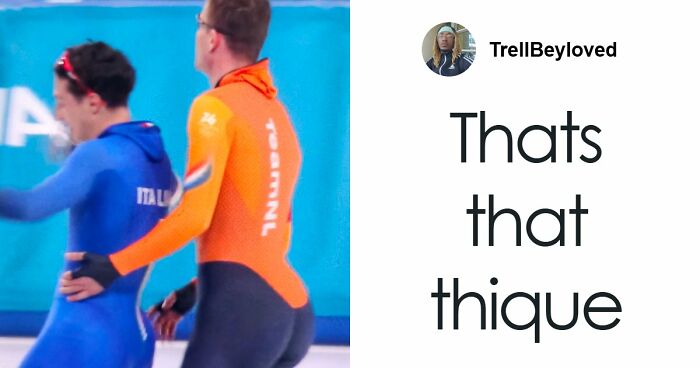
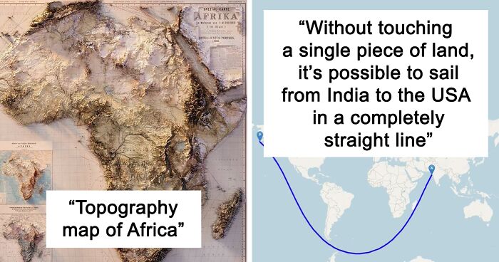
just want to run my fingers across this image ( don't make this dirty please!)
That's because in some places, people whine about paying taxes. But the jurisdiction has to get money some way, so the main occupation of the cops is catching speeders. Those are also the places where you pay a fee for every fricking thing you do.
It's probably the stretch between Cleveland and Toledo. Despite Kat Lineker's comment, the reasons for the heavy patrols on this stretch are 1. all the d**g running between US and Canada here. And 2. This is one of the busiest roads for human trafficking in the United States. So patrols are numerous. Catching you speeding here is just a ticket of opportunity.
Load More Replies...The sheer audacity of their attempt is mind-blowing. That they failed is no surprise. Even the worst pizza you'll get in Italy (and yes I've had some bad ones) are better than the best Dominoes one I've ever encountered (although TBF they were all a very long time ago). https://www.bbc.com/news/business-62487788
Load More Replies...Whatever the source for this map, it's got it horribly wrong - because it suggests that the industrial revolution hadn't reached Scotland or much of northern England by the 1880s - hadn't even reached Liverpool by the look of it. The first intercity railway opened in 1830 between Liverpool and Manchester and was a bit of a significant landmark in the industrial revolution, which arguably began in around 1705 in Cornwall (Newcomen's pumping engine, with a bit of help from France), which according to this map only got the industrial revolution in the 1850s. And never mind what was going on in Italy and Spain... Basically, the map's nonsense.
Yeah. I was going to say I think we can go a hundred or so years earlier for the start of the Industrial Revolution. And let's not leave out the other side of the pond, or Chinese technology, either.
Load More Replies...Considering that mechanised weaving was being used in the North West of England in the 1760's, this map is definitely incorrect. It also doesn't say which one of the 5 industrial revolutions it represents. Going by the date of 1840 onwards I think it represents the expansion of steam engineering and manufacturing.
Steam power for industry dates back to to the early 18th century if not before: Thomas Newcomen, in Cornwall in about 1705-1712 (I've read of different dates); inspired by ideas from France - Denis Papin, with Thomas Savery's steam pump of 1698 being the first commercial industrial application of steam power. So, the map isn't about steam power either.
Load More Replies...Probably depends on how you define the industrial revolution's start. Was it the steam engine? Was it something else?
Load More Replies...Cricket is a tricky one because there are three main formats and you can have a separate champion in each. Australia are the Test and ODI champions, but India are the T20 champions.
We really should be making all sports multi-gender. Let everyone play everyone!
Here: https://drifttravel.com/compare-your-travel-to-david-attenborough/
Load More Replies...For those commenting about him being a pedo etc, I suggest that you do your own research. Like actually read about how it all happened and about Evan Chandler. Michael Jackson was odd and eccentric, and made many questionable choices, sure, but imo he did no SA.
Do your own research yourself. Just look up "duck juice" and stop defending a paedophile because you happen to like his work. Regarding "questionable choices", would you like to elaborate on any of those?
Load More Replies...Click the link under the map. https://x.com/Locati0ns/status/1832452865635254568/photo/1
Load More Replies...To be fair, for most of the country, businesses are kinda far from homes. We did have a culture of walkable businesses before the turn of the century. Now, not so much.
Yeah, when your ancestors mostly from european countries landed in the continent, they brought their culture with them. Walkable and liveable cities. Than you let the greed take over, and made highways, parking lots and malls instead of green towns And when the american car industry sucked, cities like Detroit went to hell with it. Greed and narrowness.Therefore, a building from 1910 is for you a "historical treasure", while in Europe is just a normal building, nothing special.
Load More Replies...The "poor" countries are the ones that were colonized and had their precious resources stolen by the "rich" countries.
These 'poor' countries are still wealthy in natural resources. But pre-colonialism they had fragmented leadership (no real countries), and post-colonialism most of them have corrupt leadership.
Load More Replies...Some very wealthy Middle Eastern countries are included here in the poor south.
Depends, do they mean the country being rich or the wealth of the people living there?
Load More Replies...Oh yes, the famous poor gulf countries.. And China, what a terrible economy compared to Russia..
Not so much anymore. So many countries do not fit into these stereotypes. China is hardly poor. South Africa. Israel. United Arab Emirates. Dubai. South Korea. Taiwan. Is every country in the North rich? Estonia. Turkmenistan. Chechnya, etc. Macedonia, Slovakia, the other Balkan countries.
You collect all the tears and extrapolate from there.
Load More Replies...Better? Worse? Without metrics, this just looks like somebody's opinion.
Even with metrics, and I'm sure they had some, it's still an opinion because someone chose which metrics.
Load More Replies...Since Canada pretty much had more immigration than any country on earth last year I would say your comment is inaccurate.
Load More Replies...I love these kinds of maps. I'm a very visual person, maps and graphs are my love language!
These maps give an insight into the internal structure of how our world is constructed.
I love these kinds of maps. I'm a very visual person, maps and graphs are my love language!
These maps give an insight into the internal structure of how our world is constructed.
