ADVERTISEMENT

Are you a fan of cartography but curious to see the world through a different lens? Have you ever wondered how many blue whales would fit into the Vatican? Or what the ancient continent of Pangea would look like with modern political borders? Or maybe you would just like to see how Manhattan looked when it was still called New Amsterdam?

If you've said "yes" to at least one of these, you're in luck! Bored Panda has prepared a compilation of cool maps from the Vintage Maps page on X, where you can learn history and interesting new facts through the medium of cartography. So, scroll through these maps and marvel at how cool our world is.

More info: X (Twitter)

#1

Antique 1870s cashmere shawl featuring a detailed map of Kashmir with intricate patterns and landmarks.

vintagemapstore Report

Stardust she/her
Community Member
Premium
15 hours ago Created by potrace 1.15, written by Peter Selinger 2001-2017

Kashmir is such a beautiful place but it’s honestly a shame that the situation is such that it’s unsafe to visit

View more comments
RELATED:
    #2

    Vintage Japanese star map from 1677 showing constellations and celestial details in a detailed cartography style.

    vintagemapstore Report

    Nicole Weymann
    Community Member
    12 hours ago (edited) Created by potrace 1.15, written by Peter Selinger 2001-2017

    I wonder what constellations they used. Right-hand corner looks like Orion, so they seem to have seen a similar picture in that group of stars.

    View more comments
    #3

    Map of Australia showing population density with highlighted urban areas for a cool map from cartography enthusiasts collection.

    vintagemapstore Report

    Manic Mama
    Community Member
    15 hours ago Created by potrace 1.15, written by Peter Selinger 2001-2017

    I grew up right in the centre, and I can tell you there's a very good reason why all the people live where they do.

    View more comments

    Today, we think of maps as visual representations of information. As evident from this list, maps can show more than just geography. They offer us historical comparisons, goofy facts, and even where the word "apricot" came from. Today, we think of maps as accurate, reliable information.

    But in the past, maps were a mix of artistry, imagination, mythology, and just a dash of geographical knowledge. Take the Borgia Map of the late 18th century, for example. Although it claims to be a map of the world, we could hardly recognize what it even is. There are illustrations of humans and animals on it, and the south is at the top.

    ADVERTISEMENT
    #5

    Map showing the Roman Empire and the Mongol Empire at their peaks highlighting historical boundaries in a cool maps style.

    vintagemapstore Report

    Robert Trebor
    Community Member
    16 hours ago Created by potrace 1.15, written by Peter Selinger 2001-2017

    Looks like a reclining blue dragon nibbling on the Balkans.

    View more comments
    ADVERTISEMENT

    According to the Borgia Map, North Russia was "Asia Major." Its creators claimed that dogs were stronger than lions there. The Hyperborean Mountains (possibly the Ural Mountains) were said to be the dwelling place of griffins and tigers. They also got some things right, like Alexandria in Egypt. However, the description of the phoenix, a bird that supposedly lived there, was a dash of mythology.

    ADVERTISEMENT

    "Phoenix, the sole most beautiful and solitary bird in the world, burns itself in an aromatic fire, and in three days is recreated from its ashes," the description on the Borgia Map says. Cartographers note that in many other maps of that time, Jerusalem was the center, hence why the maps were oriented to the east. They speculate that the Borgia Map, with its orientation to the south, was purely for decoration.

    #7

    Map showing locations of cities founded by the Roman Empire outside Italy with red dots on a Europe map, cool maps collection.

    vintagemapstore Report

    Kira Okah
    Community Member
    17 hours ago Created by potrace 1.15, written by Peter Selinger 2001-2017

    I'm trying to work out exactly what one that is in SW Wales. Is that Moridunum perhaps? Modern name Caerfyrddin/Carmarthen. A LOT of historians do like to claim that Romans never went that far west in Wales, in spite of the clear evidence in Carmarthen itself. Random map on the internet possibly being more accurate than quite a number of Roman Britain historians.

    View more comments
    #8

    Vintage illustrated map of the Hundred Acre Wood featuring Winnie-the-Pooh landmarks, a cool map for cartography enthusiasts.

    vintagemapstore Report

    Stephanie Did It
    Community Member
    13 hours ago Created by potrace 1.15, written by Peter Selinger 2001-2017

    This map was on the inside covers of my aunt's first edition copy. I adored that book.

    ADVERTISEMENT
    ADVERTISEMENT

    Not all ancient maps were of land. The oldest nautical map of the Western World, the Carta Pisana, was supposedly designed in the 13th century and mapped out the Mediterranean basin. Different from the Borgia Map, the Carta Pisana is impressively accurate.

    The Italian coastline is represented proportionally, and the most important ports are all in their precise locations. Historians call the Carta Pisana a turning point in mapmaking in the Middle Ages. It wasn't just a political or religious representation of the world, but practical and of unmatched precision.

    #10

    Map comparison showing Brazil’s size outlined in red over the contiguous USA in a cool map from cartography enthusiasts.

    vintagemapstore Report

    Nea
    Community Member
    4 hours ago Created by potrace 1.15, written by Peter Selinger 2001-2017

    I read contiguous as contagious 🫢

    ADVERTISEMENT
    ADVERTISEMENT

    The typical maps of the Middle Ages are called Mappa Mundi. The Hereford Mappa Mundi, for example, is the largest medieval map (5’2” by 4’4”). As was right for its time, its creator wasn't very keen on geographical accuracy. The Hereford map included depictions of Heaven and Hell. Anthropologist Francesca Small's verdict for it was "all propaganda, religious propaganda."

    #13

    Map showing the origin and evolution of the word apricot across different languages in Europe and the Mediterranean region.

    vintagemapstore Report

    Ace
    Community Member
    Premium
    11 hours ago Created by potrace 1.15, written by Peter Selinger 2001-2017

    So Apricots are just Precocious Peaches! I love this fact.

    View more comments
    #14

    Map of Europe illustrated with national animals, showcasing a creative and cool map concept for cartography enthusiasts.

    vintagemapstore Report

    GenuineJen
    Community Member
    16 hours ago Created by potrace 1.15, written by Peter Selinger 2001-2017

    It doesn't get better than the unicorn. Bless Scotland.

    View more comments
    ADVERTISEMENT

    But there was another medieval map that was quite accurate in the geographical sense, the Fra Mauro Mappa Mundi. Today, it's considered the most accurate depiction of early Europe. However, it includes more than just the Eurasian continent. Although its top points south, there is a surprisingly accurate depiction of the African continent. It's surprising because the Portuguese traveled to the Cape of Good Hope only in 1488, and the map was created in 1450.

    #16

    Oceans centered world map highlighting continents and oceans in a unique cartography style for map enthusiasts.

    vintagemapstore Report

    GenuineJen
    Community Member
    16 hours ago (edited) Created by potrace 1.15, written by Peter Selinger 2001-2017

    It always takes me a while to get my Bering(s) with this map. It's difficult to sea strait.

    View more comments
    ADVERTISEMENT
    #17

    Map showing illuminated lighthouses around the Great Lakes, highlighting unique and cool maps for cartography enthusiasts and casual viewers.

    vintagemapstore Report

    Lee Gilliland
    Community Member
    Premium
    45 minutes ago Created by potrace 1.15, written by Peter Selinger 2001-2017

    I miss lighthouses. We even had floating ones for shoals.

    View more comments
    ADVERTISEMENT

    If you've ever seen the "Blue Marble" image that Apollo 17 took of the Earth (that was originally taken upside down), you'd have a pretty similar picture of Fra Mauro's Mappa Mundi. Of course, the accuracy would be lacking, but the general shape of the coastlines is still there. "The comparison is stunning when you consider that Fra Mauro compiled his data from the travel tales of myriad 15th century sailors," according to NASA scientists.

    #19

    Black and white vintage map of Africa showing borders defined by ethnicity and language for cool maps and cartography fans.

    vintagemapstore Report

    Jihana
    Community Member
    15 hours ago Created by potrace 1.15, written by Peter Selinger 2001-2017

    Took me a while to learn all 54 of the current countries. I'm not learning that map!

    View more comments
    ADVERTISEMENT
    ADVERTISEMENT

    Which of the maps on this list caught your attention the most, Pandas? Share your thoughts with us in the comments! Were there any other quirky and interesting maps that you expected to see here but didn't? Tell us all about it in the comment section as well. And if you'd like to see even more cool maps you probably haven't seen before, be sure to check this compilation where you can learn new facts about the world through unconventional maps!

    #22

    Map showing the Mississippi River and its tributaries across the central United States, a cool map for cartography fans.

    vintagemapstore Report

    Who? Me?
    Community Member
    1 hour ago Created by potrace 1.15, written by Peter Selinger 2001-2017

    Always liked how it got to southern LA and was like 'Nope, I'm outta here!' and just makes a mad dash for the gulf

    View more comments
    ADVERTISEMENT
    ADVERTISEMENT
    #25

    Map showing early human migration routes with color-coded arrows on a historical world map, a cool map for cartography fans.

    vintagemapstore Report

    Stardust she/her
    Community Member
    Premium
    15 hours ago Created by potrace 1.15, written by Peter Selinger 2001-2017

    I often think about those people who migrated across Oceania. Those islands would’ve been very small and spread so far apart yet humans were able to somehow do it. I wonder how many of them didn’t make it, sailing across vast distances can be pretty hard especially with wooden rafts yet somehow just enough of us did

    View more comments
    #26

    Vintage map of New Amsterdam, now New York City, showcasing historical details for cool maps and cartography enthusiasts.

    vintagemapstore Report

    Kelly Scott
    Community Member
    4 hours ago Created by potrace 1.15, written by Peter Selinger 2001-2017

    Sometimes I wish I could just raze NYC completely and make it the way it used to be.

    View more comments
    #27

    Map comparing the sizes of dwarf planets Ceres and Pluto to Texas and the Moon on a US geographic background.

    vintagemapstore Report

    Stardust she/her
    Community Member
    Premium
    15 hours ago Created by potrace 1.15, written by Peter Selinger 2001-2017

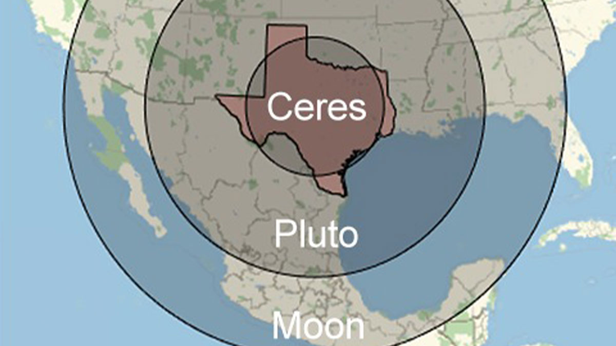
    I will never shut up about how Pluto gets more attention than all the other dwarf planets just because it’s the only one you remember. The other dwarf planets are equally as interesting with interesting histories as well. Did you know that at one point Ceres was demoted from a planet to an asteroid and then to a dwarf planet? Did anyone complain back then about their favourite planet Ceres becoming an asteroid?

    View more comments
    #28

    World map constructed from various local coins representing currency in a cool maps collection for cartography enthusiasts.

    vintagemapstore Report

    Stephanie Did It
    Community Member
    13 hours ago Created by potrace 1.15, written by Peter Selinger 2001-2017

    The US has minted its last one cent coin as of 2025, so no more pennies.

    View more comments
    ADVERTISEMENT
    ADVERTISEMENT
    #29

    3D US elevation map showcasing terrain height variations, perfect for fans of cool maps and cartography enthusiasts.

    vintagemapstore Report

    ƒιѕн
    Community Member
    17 hours ago Created by potrace 1.15, written by Peter Selinger 2001-2017

    The Ozarks look like a tiny little bump out there all alone.

    View more comments
    #30

    World map highlighting cradles of civilization with key regions noted in a vintage style cool map for cartography enthusiasts.

    vintagemapstore Report

    Stardust she/her
    Community Member
    Premium
    15 hours ago Created by potrace 1.15, written by Peter Selinger 2001-2017

    Something I love is how every culture has at some point had a mythological story about a great flood as it shows how our cultures have originated near rivers and experienced major. river flooding at some point

    View more comments
    #31

    US map showing state borders following natural features like rivers and mountains in a cool map style.

    vintagemapstore Report

    nottheactualphoto
    Community Member
    16 hours ago Created by potrace 1.15, written by Peter Selinger 2001-2017

    Connecticut River: "What am I, chopped liver?"

    ADVERTISEMENT
    ADVERTISEMENT
    #33

    North America map from 100 million years ago showing ancient coastlines and geographic features in a cool maps collection.

    vintagemapstore Report

    Who? Me?
    Community Member
    1 hour ago Created by potrace 1.15, written by Peter Selinger 2001-2017

    That explains how the Grand Canyon was formed so quickly!

    #36

    Ancient Earth world map showing continents and oceans around 19,000 B.C. for cool maps and cartography enthusiasts.

    vintagemapstore Report

    ƒιѕн
    Community Member
    17 hours ago Created by potrace 1.15, written by Peter Selinger 2001-2017

    We can get great satellite pics from 19000 BC but can't get a good bigfoot pic in 2026

    ADVERTISEMENT
    ADVERTISEMENT
    See Also on Bored Panda
    #38

    Map showing all territories of the United States outlined across the Pacific Ocean in a cool maps collection

    vintagemapstore Report

    Multa Nocte
    Community Member
    Premium
    17 hours ago Created by potrace 1.15, written by Peter Selinger 2001-2017

    Someone better remind the orange Oompa-Loompa that Bad Bunny is actually an American.

    View more comments
    #39

    Map of British accents divided by pronunciation differences shown in colorful regions, a cool map for cartography enthusiasts.

    vintagemapstore Report

    Kira Okah
    Community Member
    16 hours ago Created by potrace 1.15, written by Peter Selinger 2001-2017

    You can tell the exact town my parents are from if I say just one particular word, nowhere else in the UK let alone anywhere else in the world uses that word except that one single town. No I am not saying the word because it really is that specific.

    View more comments
    ADVERTISEMENT
    ADVERTISEMENT
    See Also on Bored Panda
    #41

    Map showing uneven distribution of population and wealth worldwide, highlighting key regions in a cool cartography style.

    vintagemapstore Report

    Multa Nocte
    Community Member
    Premium
    17 hours ago Created by potrace 1.15, written by Peter Selinger 2001-2017

    Hey New Zealand! You are finally on the map!

    #43

    Map showing Bigfoot sightings across the US with data points highlighted, featured in cool maps for cartography enthusiasts.

    vintagemapstore Report

    ƒιѕн
    Community Member
    17 hours ago Created by potrace 1.15, written by Peter Selinger 2001-2017

    And not a single clear picture of said Bigfoot exists.

    View more comments
    ADVERTISEMENT
    ADVERTISEMENT
    See Also on Bored Panda
    #46

    Climate comparison map of North America and Eurasia highlighting temperature zones with country labels and color codes.

    vintagemapstore Report

    Stardust she/her
    Community Member
    Premium
    15 hours ago Created by potrace 1.15, written by Peter Selinger 2001-2017

    India and I think to an extent China have huge variations in climate across the country. What I know about India is that while it may be snowing in Kashmir, you could be boiling to death in South India while North-East India enjoys heavy rains

    View more comments
    ADVERTISEMENT
    ADVERTISEMENT
    See Also on Bored Panda
    #50

    Map showing the legality of owning a kangaroo in the United States with color-coded states and key for permits.

    vintagemapstore Report

    Gingersnap In Iowa
    Community Member
    17 hours ago Created by potrace 1.15, written by Peter Selinger 2001-2017

    Trying to decide if I should move to Illinois/get permit for kangaroo OR move to Wisconsin and go wild owning a kangaroo without a permit.

    View more comments
    #51

    World map showing male hairiness frequency by region with color gradients, a cool map for cartography enthusiasts.

    vintagemapstore Report

    Eggwodd
    Community Member
    Premium
    3 hours ago Created by potrace 1.15, written by Peter Selinger 2001-2017

    I remember when I visited Greek beaches - The hairier the Greek, the smaller the Speedo!

    View more comments
    ADVERTISEMENT
    ADVERTISEMENT
    See Also on Bored Panda
    #55

    Vintage map of the Old World from 1517 showing historical empires and regions in green on a blue background.

    vintagemapstore Report

    Kira Okah
    Community Member
    16 hours ago (edited) Created by potrace 1.15, written by Peter Selinger 2001-2017

    The area to the north of Joseon and east of Northern Yuan was the Jianzhou Jurchen Confederation. About 50 years after this map, the Ming tried to destabilise the Confederation, taking the grandson of one of the Jurchen chieftains (Giocangga) hostage and allying with another chieftain (Nikan Wailan). That hostage grandson was a boy named Nurhaci, who would go on to become the chieftain of the Jianzhou Confederacies, united the Jurchen under the name of "Manju" (anglicised: Manchu, believed to be an older name for the Jurchen) and under his banner of the Later Jin (renamed Daicing Gurun/Great Qing by his son and successor Hong Taiji, the Qing Dynasty you might know it as). They would become part of the fall of the Ming, and I find the lack of presence of the Jianzhou Jurchen Confederation annoying for how important they are to history, especially since the Four Oirat/Oirat Confederation is on here (so it is including important Asian continent Confederations).

    View more comments
    #56

    Colorful geological map of North America showing detailed terrain features and elevations for map enthusiasts.

    vintagemapstore Report

    ƒιѕн
    Community Member
    16 hours ago Created by potrace 1.15, written by Peter Selinger 2001-2017

    Why does everything west of the divide look like Mordor

    View more comments
    ADVERTISEMENT
    ADVERTISEMENT
    See Also on Bored Panda
    #57

    Choropleth map showing percent of population rating their state as the worst place to live in cool maps collection.

    vintagemapstore Report

    Ace
    Community Member
    Premium
    10 hours ago Created by potrace 1.15, written by Peter Selinger 2001-2017

    Fear and self-loathing in Illinois.

    View more comments
    #58

    Vintage map showing Thomas Jefferson’s proposed division of western U.S. territory into states in 1784, a cool map for cartography fans.

    vintagemapstore Report

    Auntriarch
    Community Member
    14 hours ago Created by potrace 1.15, written by Peter Selinger 2001-2017

    I really don't want to know how he came up with Assenisipia

    View more comments
    #60

    US map highlighting the 50 drunkest counties with color-coded data, a cool map for cartography enthusiasts to enjoy.

    vintagemapstore Report

    Unicorn
    Community Member
    14 hours ago Created by potrace 1.15, written by Peter Selinger 2001-2017

    Can we assume grey means "no data available" ?

    View more comments
    ADVERTISEMENT
    ADVERTISEMENT
    See Also on Bored Panda
    #63

    Map of the United States showing kangaroo ownership legality with color-coded states in a cool maps collection.

    vintagemapstore Report

    Stardust she/her
    Community Member
    Premium
    15 hours ago Created by potrace 1.15, written by Peter Selinger 2001-2017

    Anyone else sometimes experience déja vu?

    View more comments
    ADVERTISEMENT
    ADVERTISEMENT