40 “Amazing Maps” That May Give You A Unique Perspective On The World (New Pics)
Interview With ExpertIf you were born in the last 30 years, there’s a good chance you’ve never actually had to rely on a paper map. You might have seen them at amusement parks or folded up in the glove compartment of your dad’s car. But you probably weren’t using them to navigate from the passenger seat while on a road trip with your best friend.
Despite the fact that the majority of the world now uses apps to provide us with directions, there will always be a place for maps. And if you disagree, I hope that the Amazing Maps Instagram page will help change your mind. This account has amassed nearly 75K followers for sharing fascinating maps of the world, along with fun facts and interesting statistics. Below, you’ll find some of their most intriguing posts, so be sure to upvote all of your favorites. And keep reading to find conversations with map experts Ivos Gajdorus from Mapotic and Minas, Creator of MapChart!
This post may include affiliate links.
Regional Giraffe Patterns
The reticulated for me, I like the scale-like pattern
Load More Replies...As usual, the research ignores data from Australian giraffes. Hmphh.
What strikes me the most here is just how limited giraffe territory has become.
Pretty much where I'd expect the Angolan and South African ones to be.
Remote work isn’t just a trend, it’s the future of work. qs Work Remotely from your own house. We just want your typing skills, You can make more than 120USD/Hr. No matter where you are. Let’s Grow together and do great things, even if we’re far apart… Take a Look……… Begin here>>>>>>>>> 𝕎𝕨𝕨.𝔼𝕒𝕣𝕟𝔸𝕡𝕡1.ℂ𝕠𝕞
Passenger Trains In The United States vs. Europe
I don't think the US will ever have a truly great national rail system. Amtrak will be as good as it gets
But Elon will build the Hyperloop bro! Any year now bro! /s
Load More Replies...I grew up in Brazil, and the pattern it is basically some dashes scattered among three or four major cities. I was gobsmacked when I visited Europe, you can get anywhere by train.
A Ferrovia Norte-Sul of president Sarney has been complered?
Load More Replies...The US used to have many more railway lines back in the days of private railroad companies. Also Europe is so densely populated, it's easier to travel by good, efficient, high speed train than fly.
The US has many huge unpopulated or underpopulated areas where rail lines aren't worthwhile. There are no such regions in Europe.
Load More Replies...Add to the map Rail replacement services and the UK would have a nice area of another colour!
Quebec City-Windsor corridor is ripe for high speed rail but Via Rail doesn't own most of its own tracks, so their trains have to yield to CN freight trains.The closest thing to high speed rail in Canada is a high speed rail study: https://www.youtube.com/watch?v=W32klYkTxCQ.
england invented the train. the wright brothers invented the airplane. it's faster.
There are many different regional rail lines in the USA . What you seem to have depicted here are only the main national routes . That's like posting a national map of the Interstate highway system only and totally omitting any other roadways . That being said I would indeed like more RR options .
How A Coastline 100 Million Years Ago Influences Modern Election Results In Alabama
Wait who's red and who's blue? I'm not american so don't know
Load More Replies...You never know how previous historical events will change today's decisions... and in this case, it changed a lot!
To learn more about maps from an expert, we got in touch with Ivos Gajdorus from Mapotic. Mapotic is a startup driving geospatial innovation since 2018. Originally launched as an interactive map builder for creators and communities, it has evolved into a platform delivering custom B2B mapping solutions.
By fusing satellite, IoT, location, and metadata from various sources, Mapotic creates powerful, user-friendly web and mobile applications. And today, it serves sectors including wildlife tracking, travel and tourism, logistics, and civic projects.
In 1992, Around 29,000 Rubber Ducks Fell Off A Cargo Ship In The Pacific Ocean. This Is Where They Made Landfall
Whilst it's not a good idea dumping so much plastic in the oceans, this accident has been really useful to marine scientists.
Now you know why you have no idea where a message in a bottle will end up.
One of their biggest accomplishments was something that has evaded most sailors for centuries, they traversed the North West Passage. But on the downside, this can only be done thanks to the rise in temperature and severe melting of Artic Ice.
Kiribati Is The Only Country In The World That Is In All Four Hemispheres
From the most northerly point of these island to the most southerly is 2,000km, and easterly to westerly is over 4,500km. That roughly the same distance as Vancouver, Canada to Tijuana, Mexico, and San Francisco, California to Augusta, Maine (USA). Kiribati is a tiny island nation that covers a huge area.
Thanks! This is more interesting than the graphic haha
Load More Replies...North and South of the equator and East and West of the date line. So part of the islands are in yesterday while other parts are in today, even though they are only hours apart.
Why are some of the islands labeled as Ecuador ? Oh, I saw the Meridiano ", so Ecuador must be equator in another language. Spanish / Italian ?
Spanish, hence the name of the South American country. That threw me for a second as well.
Load More Replies...We have summer today. Guy on island next to it: we had winter yesterday.
There are infinite hemispheres, depending on where you draw your imaginary line. We mostly use two lines.
Load More Replies...Virgin Forest Cover 1620 vs. Today
Agree with those saying this is manipulative; this is NOT a map representing deforestation. The reforestation of the eastern US is something we rarely hear about. The US actually does a good job of preserving forests and natural resources although the current regime would love nothing more than to sell it all off to the highest bidder and let them destroy it if they so choose.
Reforestation is good in one respect but what it tends to lack is the diversity of species that originally grew there. Managed reforestation is essentially replacing a diverse habitat with fast-growing commercial stock.
Load More Replies...Wait, what is the meaning of "virgin" in this context? Surely the native peoples lived on those areas already. How come the forest is "virgin" if entire human populations lived there? "Preserved", sure, but not virgin, right?
These are forests which have never been logged by modern logging companies. The US is still highly forested. Especially in comparison to Europe.
Load More Replies...I wonder how it compares to South America, particularly the Amazon region where there's been shocking deforestation.
Yes. I would also like to see maps of South America and Africa
Load More Replies...First, we wanted to hear why Ivos believes maps are so important. “The question of ‘where’ is deeply embedded in most human activities,” he shared. “Maps are a powerful form of visual interpretation that help us make sense of locations — especially those we are not familiar with. They turn complex spatial information into something understandable and usable.”
We also asked the expert if he happens to have a favorite map. “One of the most impactful maps powered by the Mapotic platform is the Ocearch Shark Tracker, which helps the global community better understand changes in our oceans by tracking the movement and behavior of sharks. They reveal patterns and shifts we would otherwise miss.”
Each Section Has 10% Of The World's Population
The Spilhaus Projection. In 1942, Athelstan Spilhaus Produced A World Map With A Unique Perspective, Presenting The World's Oceans As One Body Of Water
Cycle Paths Of Europe
So's my patch of northern Germany :) I love my morning cycle to work.
Load More Replies...“ Man sits next to me on train. Man : Loads of psychopaths around here Me : Really? Man : Loads mate Me: How do you know? Man: There's signs aren't there? Me: I guess? Man: I love them *47 minutes of awkward silence* Man leaves the train, he has a bike . I realise he was saying "cycle paths"🤣”
I lived in London 20 years ago, and it terrified me to ride my bike. I'm hoping things got better, but london drivers were crazy. Not Rome levels of crazy, but still.
I've always wanted to do the informal Drսnkard's Bicycle Tour of Belgium. It's a small, flat country with hundreds of breweries. ETA some unicode. Jeebus, BP.
If you’re interested in making your own maps, Ivos shared some advice. “Before creating a map, think carefully about the information structure,” he shared. “Maps are just one way to interpret data, and thoughtful categorization and classification are key for building complex maps that are easy to navigate and understand.”
A Map Of Geography Terms. Any You Didn't Know?
I had a textbook with this exact same illustration in teh 1980s.
They still make posters of it. There's one up in a class in my school.
Load More Replies...I don't see key (as in a small, low-lying island formed on a coral reef, like the Florida Keys) on this map.
Never mind teachers, I'm yelling it! Where's my oxbow lake?! Also arches and stacks!
Load More Replies...ive had an ongoing argument with my brother for years on if plateaus are mountains. I know they are plateaus but do they qualify as mountains too since they are so tall?
Plateaus aren't tall, they're large areas of relatively level ground that are above sea level and which terminate in a steep drop on at least one edge. The Colorado Plateau, for example, covers around 130,000 square miles and extends over parts of five states. It has a series of cliffs and canyons which includes the Grand Canyon along one edge but the rest is bounded by various mountain ranges and basins. Unlike mountains, which are either volcanic 'blisters' or folds in the crust, plateaus are formed by entire swathes of land being pushed up as one piece from underneath. You've seen the effects of earthquakes where one side of the resulting crack has been lifted by a few feet: imagine that on a massive scale.
Load More Replies...Railways In China, 2008 vs. 2020
Well no, they're not; they're just not as bad as road or air transport..
Load More Replies...Railroads can be good as long as they don't ruin local ecosystems. I don't think nature is a big concern in China.
the train maps must be confusing, i know i would get lost in 5 seconds if i had to figure out which train i should take
Same here I would also get lost cause I don't know which one was the right train for me to take.
Load More Replies...They certainly have had the advantage of being able to build cities and infrastructure from the ground up, with modern technology built into everything from roads to buildings to social control... The US doesn't seem to care that it's infrastructure is well beyond it's engineered lifespan and is falling apart, because clearly, we must fight white Christian racism as if that's a thing. 🙄
White Christian racism most certainly is a Thing. It's not a good thing, either.
Load More Replies...One of the most impressive things about China is its integrated high-speed rail network
They also have the population needing fast reliable transport to support such a network being developed today. Europe's rail network was developed at a time when a large population needed to go places fast.
Load More Replies...Don't forget the distances aren't that far apart, compared to the US.and note that most of the population is in the east of the country.
Load More Replies...Nah. It's just not the way most Americans think. They are used to individualised transportation and not mass transportation.
Load More Replies...That's an incredible rate of growth. And I agree with the below comment.
Xinjiang, China. The Farthest Place On Earth From Any Ocean
Anyone interested in buying my shop, Xinjiang Surfboards?
Load More Replies...Finally, Ivos shared a fun fact about ancient maps. “According to many sources, the oldest known map dates back around 25,000 years. It was carved into a mammoth tusk and discovered in Pavlov, Czech Republic — proof that even prehistoric people didn’t like getting lost.”
You can learn even more about the topic right here!
A Map Comparing Actual Distances To Their Representation On The Mercator Projection
thanks for the recommendation. thats genuinely crazy
Load More Replies...Yellow is Russia. Blue is France. Pink is Greenland. Holy c**p! truesize-6...00-png.jpg
Wrong. Mercator projection was and still is very useful for the seafarers to plot their position and routes to be sailed. They know very well for the distortion of the chart but are not concerned. Only the laymen do so.
Load More Replies...Just watched an episode of West Wing where the "Cartographers for Social Equality" came in to talk to the staff about maps and social biases. It's insane how different maps are from the world, and how our perception is tied to them. I needed a minute.
Old salt here. Mercator projection is an absolutely necessary tool. Politicizing it is a major B.S.
Load More Replies...Why keep pushing this absurd lie? Russia, a single country, is 9000 km wide East to West. Africa, a continent of over 50 countries, is roughly 7400 km wide East to West.
Obesity In North America (2021)
There are states with more than 40% of the population as obese? I don't think there's enough Ozempic in the universe to account for that!
Interesting those two worst states have the lowest literacy rate, the worst education system, the most racists, probably the most MAGAs.
Load More Replies...The dark red and black are the highest concentration of poverty, Medicaid, and happen to be Republican states. Oh how they've pulled the wool over their voters eyes. SMH>
Combine easily accessible food loaded with calories and a mostly sedentary lifestyle and this is what you get.
Plus food deserts, unaffordable health care, lack of funding to schools' extracurricular activities (like gym class/after school sports), our federal policy of subsidizing mega corps that grow fields of corn and soy so large that they need to account for the curvature of the earth in their rows while ignoring small farms that grow a diverse range of crops, etc, etc
Load More Replies...Alabama is one of the states in the USA that taxes groceries. I wonder if there is a study on the impact. The tax varies by town since it's assessed by the state and town. I've bought groceries in a store that had a 10% sales tax (charged at the register) on all groceries including fresh fruits/veggies.
Load More Replies...Also happen to be the states that are the least educated, poorest, and biggest Trumper states. Go figure.
I would like to see this map in comparison to the priority of education and health care of each state.
You would see high correlation. Also, besides Texas, those are the states that take more welfare than they provide in taxes.
Load More Replies...If this map uses BMI to determine overweight and obese, it can't be trusted. https://hsph.harvard.edu/news/bmi-a-poor-metric-for-measuring-peoples-health-say-experts/#:~:text=Experts%20have%20also%20pointed%20out,)%2C%20and%20their%20metabolic%20health.
Comparing The Urban Areas Of European Capitals
Ask ANYONE from France where they're from and they will say, "A little village just outside of Paris"...
Obviously the diagram shows areas, but it would be more interesting to include population density, perhaps by means of different colours.
Load More Replies...It is. The Ural mountains are generally considered the boundary between Europe and Asia. Or the Bosphorus Strait in Istanbul.
Load More Replies...Rīga, my home city, is almost identical to Warsaw in terms of area, but we have half a million people, whereas they have 1.8. Nice to have so much free space
We were also lucky enough to get in touch with Minas, the creator of MapChart, to hear his thoughts on this topic. "Maps help us make sense of the world. They turn complex data into something visual and understandable," he explained. "Whether it’s for education, planning, or just curiosity, maps help people connect with information in a more meaningful way."
Historical And Current Grizzly Bear Range In North America
wait, if california has no grizzlies, then why are they on the flag??
Vancouver Island has documented grizzly bears ranging north of Campbell River.
I live north of Campbell River :) we very, very, very rarely get grizzlies. And when we do, everyone’s aware and vigilant lol. It’s not normal to get grizzlies up here but it has happened before.
Load More Replies...Countries Where Cheek Kissing Is A Common Greeting
Alright you win the internet today. Everyone else, exit this way.
Load More Replies...After corona the Netherlands is finally letting this go a little, thank God...we had three! I much rather wave or hug
I'm Russian, and no, it't not as common here as the map shows. Hugging, yes. Kissing, not so much.
During the Soviet Era kissing mouth to mouth was common between the communist leaders. https://en.wikipedia.org/wiki/Socialist_fraternal_kiss
Load More Replies...Homicide Rates In Different Regions Of The World
The Mexican government estimates that 200,000 firearms are smuggled into the country from the United States each year. They need to close the border with their rogue state neighbour.
Load More Replies...Poverty is also a factor and produces a similar map. High income inequality and a lack of social safety net/educational funding/affordable food and health care => higher rates of crime.
Load More Replies...Apparently Canada does not exist. That should make us harder for the U.S. to attack us at least.
Load More Replies...Yeah, we left too, but for different reasons. We left during the dictatorship because my father was a journalist who got disappeared. And my mother was a college professor, and the government was rounding up professors and students as suspected leftists. Luckily, we came to the United States, where that kind of thing will never happen.... right?
Load More Replies...And yet I have met Americans who say they won't travel to Europe because they aren't allowed to bring a hand gun.
Boggles my mind, and I'm American. Why the hell would anyone think they'd need to travel with a d@mn gun?! Good grief.
Load More Replies...Australia would be 0.854/100000, but yeah, we're missing half the world here. Btw the full list is here: https://en.m.wikipedia.org/wiki/List_of_countries_by_intentional_homicide_rate
Load More Replies...Too busy NOT murdering people. You wanna be on this map, you gotta get more violent.
Load More Replies...We win!! But seriously, we have very dense population centers, with extreme poverty mixed with extreme wealth, lack of access to quality education, a lot of religion, and too many guns. Plus we're a major hub for moving d***s to their final destination, the USA. On top of all that, our police force is very corrupt, and often involved in homicides and d**g and human trafficking. There are parts of cities which are completely lawless, and the police are afraid to enter altogether. Prior to the Olympics and that other tournament which we are trying to forget, the government had to send in the military to create pacification squads to reduce crime in the cities to make them safe for foreigners. Bem-vindo!
Load More Replies...We were also curious about Minas' favorite map. "One map that always stands out to me is the 'World divided into 4 regions with the same population'. It’s such a simple idea, but incredibly eye-opening. It challenges your assumptions about population distribution and gives a powerful visual of how unevenly people are spread across the planet."
Map Of The 1910 Tour De France Route
I love how the sponsorship was already a big part of things even then. The top-right shows a schematic of a bicycle with all of the parts made by JOG highlighted.
The sponsorship started from the very beginning. The reason for the maillot jaune (Yellow Jersey) is that the original organiser, a newspaper called L’Auto was printed on yellow paper.
Load More Replies...nowadays, they sometimes start in Great Britain, or in Belgium, come through Belgium...
They've even started in Danmark, I guess they needed a few flat stages.
Load More Replies...The Red And Orange Areas Have Equal Population
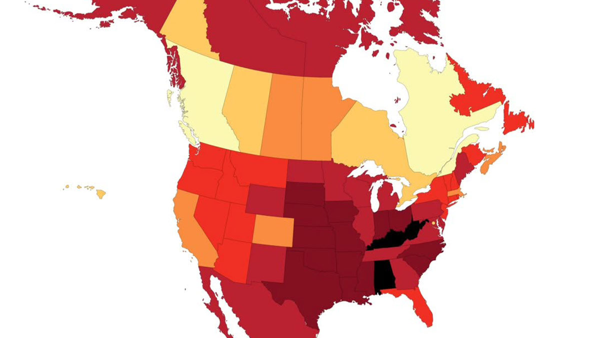
This is why PEOPLE VOTE and not land. Everytime I see a nationwide election map I want to scream. The entire state of Wyoming has less people in it than the metro area I live in that is barely 50 miles wide. But those country bumpkins get two Senators and we don't even get one.
The electors system was suited to the 18th century when very few people could travel so it made sense to gather locally and mandate one person to carry the collective vote to the center. Today? It's outdated. Get a census of all voters, let'em vote, count the votes. Whoever gets more votes gets the job.
Load More Replies...I get the impression very few people here paid attention in civics class. I live in a "flyover" state - I definitely don't want a bunch of city-bred people with different priorities deciding all politics for my area; any more than they want farmers making their policy. Should keep 95% of politics local and limit all Federal control to military and currency
I feel sorry for the coastal areas who have most of the people and most of the money but due to the absurdity of our "democracy" have little power. California and New York need secede, if the south and Midwest want to live in an "christian" oligarchy let them.
Load More Replies...i bet the orange areas have much more homeless camping. people love being near the ocean
(sigh) If only red U.S. and blue U.S. could have an amicable divorce, and figure out a good way to apportion the land. As long as all of us are stuck together in one country, nobody will be happy.
Must have don't care about the land. They care about the money
Load More Replies...Every state has two senators. Representatives are based on population. More people more representatives.id like to know where you live and why you think you don't have a senator
A Map Of Europe’s Most Common Surnames
I have an Italian friend whose surname is Rossetti, does that mean little Rossi?
March 2025 - "In the U.S., an analysis based on U.S. Census Bureau data ranked Smith, Johnson, and Williams as the three most common surnames. The U.S. has over 150,000 different last names, reflecting its diverse population."
Load More Replies...For the Netherlands right? I thought it would be de Vries!
Load More Replies...According to the National Records of Scotland, in 2024 the most common surname is Scotland is still Smith. According to the 2021 census, the most common surname in Wales is Jones...
Load More Replies...And if you're interested in trying your hand at map making, Minas recommends starting simple and focusing on clarity. "You don’t need to be a designer or a GIS expert to make a compelling map," he shared. "Tools like MapChart let you get started right away, even with no experience. The most important thing is to have a clear purpose or story you want your map to tell."
Finally, the expert added that he's always impressed by the creativity people show when making maps. "From fictional worlds to data-driven insights, the possibilities are endless."
The First World Map By Anaximander Of Miletus (610bc-546bc), Greek Philosopher
Not actually the first, the Babylonians had got there first https://medium.com/mapping-civilisation/mapping-antiquity-part-2-the-babylonian-world-map-d3866139d1ba Clipboard0...e7a37a.jpg
It's called the T-O map by many people, and honestly with the amount of information they had its pretty darn accurate... especially if you compare it to the area that it's trying to do. The ocean part is just the only part that's wrong.
The "world" was a lot smaller then if you define "world" as what people knew about.
People knew about the rest of the world, just not the same people. 😉
Load More Replies...Map Of Languages Spoken In China
Year would be helpful. I'm afraid Uygur and Tibetan (e.g.) are much on the decline. In the case of Uygur, the threat of being arrested and brought to a labor camp makes the language unattractive. Suppression works, unfortunately.
Same for Tibetan, the culture is heavily oppressed by the Han chinese.
Load More Replies...tibetan is spoken in Tibet. China invaded it. Tibet has never been considered legitimately a part of China.
I've often been ridiculed for asking "which Chinese language." This illustrates my point. "Chinese" is not one language.
Highway 1 In Australia. The Longest National Highway In The World At Around 14,500km
What an epic journey that would be. Have any Aussie BPs ever tried it?
I want to. Will let you know in about 100 years time Context: I love procrastinating
Load More Replies...Had a car dealer guy I know urge me to test drive a Ford Lightning. "Since it's VERY unlikely I would buy one, I pass".."why wouldn't you buy one?".."well, the kids live in NC, 14 hours away. I will NOT make the trip a 20 hour one (recharging)".
Load More Replies...We hope you’re enjoying this list of fascinating maps, pandas! Keep upvoting all of your favorites, and let us know in the comments down below what the most interesting map you’ve ever seen was. Then, if you’d like to check out even more maps that will teach you something new about our world, we’ve got the perfect Bored Panda list for you to read next right here!
Dividing British Columbia Into Three Regions With Equal Population
Anyone living in the blue like me? 😊 (I spent years in the red though haha)
I’m living a little to the right of the Rockies, in the grey!
Load More Replies...Location Of Every City Founded By The Roman Empire, Outside Of Italy
Considering there are over 500 cities founded by Romans in Turkey alone, some of them still standing (including Antalya and Constantinople), I think this map is quite wrong.
Yes, it seems like it's pretty much defining only what would later be referred to as the Western Roman Empire, ignoring the East almost entirely, Greece as well as Turkey, but oddly including just one middle-eastern city on the Med, I'm guessing Tyre (not founded by them either, but by the Phoenicians).
Load More Replies...Surprised to see that people forgot that the Romans were new kids on the block. There were Greeks, Phoenicians, Iliric tribes, etc, all of them founded cities too, especially on the Mediterranean. That's why Greece and Turkey are empty
North America 92 Million Years Ago
There are a bunch of places in Colorado (completely underwater on the map) that have fish and dino fossils, from when it was underwater and when it was flat after the water had receded but before the mountains had formed
I was so much older then. I'm younger than that now.
Load More Replies...thank goodness for the ice age. otherwise we'd all be living in appalachia.
A Portuguese Propaganda Poster Showing The Size Of Portuguese Colonial Possessions Compared To Europe
Empty land with no people is meaningless. Also F-U-C-K colonialism.
Downvote for the first sentence and upvote for the second.
Load More Replies...this division of 3rd world colonies was officially approved by Pope Julius II . . .
Melbourne Is Closer To Antarctica Than It Is To Darwin
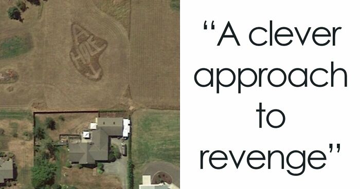
I did that from Dubbo and it took a while 😂 6-7 days driving. But I pulled over a lot as I had a duck with me who needed swims and walks
We need to know everything there is to know about the duck please. I have questions. For example, I need to know the duck's name. And why you guys went on this road trip together.
Load More Replies...Also in Australia, Perth is closer to Bali then Adelaide (nearest capital city)
The Roundest Countries
The 25 Largest Lakes In The World, Side By Side
In my lifetime the Sea of Azov has stopped being eligable for this map. When I was a child it would have been one of the larger lakes, and it provided many people with a good livelihood fishing. Now it's gone. And Russia thinks it is an nation to be taken seriously.
Methinks you mean the "Aral Sea". The Sea of Azov is a section of the Black Sea.
Load More Replies...Why is the Caspian Sea on this map of lakes? Is it a lake or a sea? If it's a lake why isn't it called that? If it's a sea, why is it included here?
The water in the Caspian is brackish, with a salinity about a third that of the oceans. The Black Sea is somewhat saltier and is also connected to the oceans via the Bosphorus.
Load More Replies...Via Bosporus, Sea of Marmara/Propontis and Dardanelles is connected with Mediterranean Sea.
Load More Replies...United States Gdp, Split In Half
Oh this is a good one. Also a d**n good reason people need to get their head out their asses and realize that urban cities pay for country roads. Also powerlines, and modern plumbing and sewage management. The big cities MAGA rails against are paying so you don't have to sh!t in an outhouse while reading a Victoria Secret catalogue by candlelight.
That's cool, but none of those dark yellow areas eat food without the light blue
Load More Replies...Look at an election Map of nearly any state. The cities, even in TX or OH, will generally vote Democratic. The same cities shown above that pay the taxes and drive the economy... But they are underrepresented in Congress...
This an oversimplification, but it is basically a symbiotic relationship; infrastructure, entertainment, manufacturing, industrialization, etc., in financial trade for; sustenance, hide, and fiber animals, and sustenance, fiber, and industrial crops. Now if both sides would realize that each has the right to exist and live, without the others disapproval or judgment, we would all be the better off for it.
The Distance From Perth To Sydney Is Greater Than The Distance From Paris To Moscow
Probably saw the distance involved and decided Moscow was the better option
Load More Replies...A Euler Diagram-Map Of The British Isles
Any Irish I've spoken to have thrown things at me whenever I've called Ireland "part of the British Isles".
It's a bone on contention. Sometimes "British and Irish Isles" is used.
Load More Replies...We need a new word that's non political. People still think the Republic of Ireland is still part of ther UK because it's part of the "British Isles". We need a word like Iberia or Scandinavia, that describes the area, without the politics.
In joint documents between the Republic of Ireland and the UK, the term used is 'these islands'. The official stance of the RoI is the RoI is not part of the 'British Isles'. - -- - - A very simple change is to use British-Irish Isles, or is a bigger change is required, Anglo-Celtic Isles, or even the Atlantic Archipelago.
Load More Replies...They are Crown Protectorates. Don't ask what that means, most Brits would struggle to explain!
Load More Replies...That was Gaul, according to Caesar. And the diagram divides the island of Ireland into two (political) parts, not three.
Load More Replies...There's an excellent video by CGP Grey on YouTube coverage this. https://youtu.be/rNu8XDBSn10?si=ZjTHDxVTOMl1nAHB
A Map Of The World Constructed From Time Zones
Here's an image showing the countries , and the time zones. world_time2.gif
The black ang green image above is what you get when you remove the country outlines, just leaving the timezones.
Looks like something that would be the world map from the very first Matrix
There's More Water In Loch Ness Than In All Of England And Wales' Lakes, Rivers, And Reservoirs Combined
It is pretty massive and deep. It's also the only lake in the UK that you can see the horizon when you stand at one end. But it is tiny when you compare it to something like one of the Great Lakes. There just aren't many large bodies of water in the UK. That being said, this "fact" surprises me because the two lochs that are southwest of Loch Ness (Lochy and Oich) are pretty big, too. Maybe it's because Loch Ness is much deeper?
I think Loch Ness is used here because it is famous. The title said that it has more water than the rivers and lakes in England and Wales, not more than the other lakes in Scotland.
Load More Replies...Greater Tokyo vs. Greater London
Japan does have that too. But yes, you do have to travel to get to it. Luckily, the transport system is fabulous.
Load More Replies...never knew Birmingham was a Tokyo suburb - you'd think there'd be more Japanese people there.
The Tokyo Fire Department (Tōkyō Shōbōchō), is the largest urban Fire & EMS agency in the world. The Tokyo Fire Department (TFD) has approximately 16,000 sworn career firefighters, 2,400 career administration staff, and 26,000 volunteer firefighters Making it the largest urban fire department in the world.
Los Angeles County Has A Greater Population Than 42 U.S. States And Territories
I went to L~A once, never going back. It's my idea of hell on earth.
Have you met Florida? Miami - awful, Clearwater - awful, Ft. Lauderdale - awful... and those are just places I've been.
Load More Replies...And some people want that small bunch of idiots to have voting power over farmers etc in states in the middle of the country. omg
if you want to locate the epicenter of the housing affordability crisis, look no further
Annnnd this is why we have the electoral college.nobody wants LA to decide anything.
It’s not presented as a plus. Where on this map does it indicate that it’s a positive or negative? What exactly is your point?
Load More Replies...What The Great Pacific Garbage Patch Looks Like Layered Over The USA
100 kg of plastic per square km is 0.1 grams per square meter. So much be really difficult to pick things up here! Like the 'Ocean cleanup project' started with. But seen them starting to collect at the largest plastic-polluted rivers also. edit: here is a good video of how it looks, not as one would think: https://www.youtube.com/watch?v=OA0Hk4FOchs&t=222
And here you can see the 1000 worst rivers who contribute the most: https://youtu.be/OA0Hk4FOchs?t=154
Load More Replies...misleading - japan and china are both the origins of 1/3 of the garbage patch, each. The USA is 5% https://ourworldindata.org/plastic-great-pacific-garbage
Check the units. Kg/Km^2. It's big and We should not be making it bigger but when that story hit a decade ago, it was heavily sensationalized. One Hundred Kilograms per square Kilometer is not what I picture when I hear "garbage Patch"
It's still plenty to be considered an environmental catastrophe. It makes its way into the food chain of several species. What's your point? "It's not a solid island (yet) so we shouldn't address it"?
Load More Replies...Route E45. The Longest North–south European Route At 5,190km
Translations Of The Idiom 'It's Greek To Me' In Different Languages
Dont't know why you were downvoted, it can be said too even thought the expression is getting old and nowadays we say more "c'est du chinois pour moi." Source: I live in France.
Load More Replies...In case you were wondering, Volapük was an artificial language devised by a German that predated Esperanto. The vocabulary was largely based on English but modified so that could hardly be recognized as such. It was also highly inflected. Not surprisingly, it didn't really catch on.
German version would be spanish. "train station" is a different version, not "railway"
Mapping Australia By The Nearest City With A Population Of 100,000 Or More
How can we be sure that Toowoomba is not in fact a 90s band from Seattle?
Load More Replies...“The city of Townsville!” Who knew the Aussies were fans of the Fairly Oddpareants?
Why is Brisbane so small? But then again, everybody in Suncorp Stadium on Gameday is basically Brizzy's entire population lol
Named after Robert Towns, who funded the settlement.
Load More Replies...The Highest Grossing Singer/Musical Artist/Band From Each US State
I felt the same way about the British map that was similar to this one
Load More Replies...And yet, he's more Detroit than Kid rock ever was...
Load More Replies...Yeah, but "from" ≠ "born", so I think this is grossly inaccurate. Eminem may have been born in Kansas, but he's from (was raised in) Michigan. Kanye West may have been born in Georgia, but he's from Chicago (raised there since he was 3, not that we really want to claim him anymore though).
Depends what you mean by "from": Joe Walsh, guitarist and singer in the Eagles (at least, after 1975) is from Wichita, Kansas. I would guess that Walsh, through the James Gang, the Eagles, and his long solo career, has grossed more than the band Kansas.
Nope! His real name is Henry Deutschendorf and he was born in Roswell, NM LOL
Load More Replies...It's funny, I always think of Pittsburgh, PA when I think of Wiz Khalifa. I never knew he was from North Dakota.
The Fray had a song called 'How to Save a Life', which you likely have heard somewhere, and has over 1.4 billion streams on Spotify.
Load More Replies...I'm a little surprised that Backstreet Boys is Florida's as I thought *NSYNC would be higher grossing than BSB
Never thought about it before, but that Kansas was named for the state they're from seems odd, especially since nothing about their music screams "KANSAS" at me. 🤨
All Roads Lead To Rome
'All roads lead to Rome' is a widely misunderstood statement. It wasn't supposed to mean that they all led to the city, as this map suggests. In the Roman times, every part of the Empire was considered to be Rome, and as the Empire was so vast, all roads almost invariably led to a part of it. It was more of a boast than it was a fact.
How Circle With A Radius Of 5,000km, Centred On Paris, Looks According The The Mercator Projection
Has anybody ever told Trump Mercator is not to scale when it comes to Greenland? Plus, big areas of Greenland aren't actually green...?
No, but they have big, beautiful minerals, not better or more beautiful than American minerals, which are the best minerals in the world, but still minerals that will be used for many big and beautiful things, such things as things you have never seen before, but they will be bigly and more beautifulier than you have ever seen.
Load More Replies...The Roman Empire At Its Peak, Superimposed On Modern Borders
Apart from sanitation, medicine, education, wine, public order, irrigation, what have the Romans ever done for us?!
Load More Replies...I am always amused about people who rail against colonialism, which of course was and is truly abhorrent, but always want to bask in the greatness of the contributions of the Roman Empire. Who themselves were the actual epitome for the definition of ancient colonialism. Just ask the Egyptians, Carthaginians, Macedonians, Seleucids, the Tribes of England and Wales, etc. Now, they did fight and try to, but were not able to subjugate the Pathians, Sassanians, Germanic Tribes, Scottish Tribes, and Irish Tribes.
Roman inventions and advancements are good, Roman colonialism (or any colonialism) is bad
Load More Replies...Comparing UK Regions To U.S. States With Similar Population
Probably because the two regions have the same population
Load More Replies...Forest Coverage By State
Just visited North and South Dakota. The endless rolling plains are quite a breathtaking sight!
Top Export Trading Partner For Each U.S. State
Explains why the moron in the white house wants to invade and conquer Canada.
Mexico, Canada, and China all make sense, but what is Utah trading to the UK and Connecticut to Germany? (Florida has a large brazilian population, so I will assume a lot of that is people doing business with their home country)
Connecticut has a lot of similar businesses to Germany (aircraft manufacturing, vehicle manufacturing, pharmaceuticals) and is located on the coast. North German seaports are pretty important to German trade.
Load More Replies...How Old Are Americans When They Get Married?
These ages are much higher than I thought they would be... which I think is an excellent thing. Bravo!
I'd be interested in knowing what the mode would be in many of these states (especially in the South)
Load More Replies...The Most Common Foreign Nationals In Each Japanese Prefecture
Surprised to see Brazilians there, but not so much when I remember that São Paulo has the biggest Japanese expat community in the world, so I guess people are finding their roots.
There are whole Brazilian neighborhoods in Japan. They are all Brazilians of Japanese decent who have since returned to Japan. But they bring with them Portuguese, Samba, and Carnaval. I went to Little Brazil in Tokyo, it was interesting, but not really all that Brazilian.
Load More Replies...China's Population Density
Yep, this helps explain the stark divide in resources in the country. The western regions are significantly poorer, largely because people from the west migrate to the east for job opportunities.
Map Of Italy In 1796
It was known as the Two Sicilies. The unification of Italy began in 1861 and was completed in 1871.
Load More Replies...Popular/Best Selling Artists By English County Of Origin
Haven't heard of most of these either. To be fair, I imagine quite a lot from Liverpool will have outsold some of these regions. Surprised Dave Dee, Dozy etc aren't there, they had loads of hits.
Ah yes, not to be mistaken with The Beatles (Painters)
Load More Replies...These Two Areas Of Africa Have Roughly Equal Populations
The Largest White Ancestry In Every US County
Always so irritating to me to people deny refugees access to EU because they "just want to have a better life (for their kids)". Like, when Europe was poor millions emigrated to the US.
Also when people say China and India "breed too much". Europe's population has grown just as much, but we just moved so many to the Americas and Australia, it looks like we are almost responsible.
Load More Replies...The largest White Ancestry I know is my Uncle Milton, who weighs 340 pounds.
Interesting that my county in Florida consists of so many people of Irish descent, I had no idea
Major North American Cities Replaced By Cities Across The Atlantic At The Same Latitude
Hey! What about the Maritimes? We're always getting left out of things.
The Word For 'Italy' Across European Languages
The etymology is wrong. it's unclear where the term "Italia" comes from. "Land of the calves" is just an ancient hypothesis, that comes from the legend of the original populations worshiping a god in the shape of a bull. This is proposed in Varro, a Roman writer from the I Century. The association came to be commonly accepted in the IV-V century, but the origin lacks any historical proof. Currently it is theorized that the name stemmed from the ancient greek "Aιθ-", meaning "fire" (that is also the origin of the name Etna, the volcan). The Greek colonists settled in Sicily and Campania in the VII century BCE, because those places had rich soil from volcanic activity. They named the place "Aιθαλία", meaning "Smoking land"
Walhaz is also wrong. The name "Walhaz" used to be a generic name for german populations living in the former Roman empire. The name effectively originated from the italian Volsci, but by the time it had totally changed meaning, and was used in the sense of "german uneducated, retrograde barbarian". The Volsci lived about one millennia before that time. It's like a current american calling an German "Hun" in a disparaging, racist way. The word evolved in use, and came to intend any "foreigner" coming from formerly roman areas. Walhaz is also the origin for Gaelic, Welsh, Wallachian, Wallon, Cornwall. The word "Walnut" comes from Walhaz (foreign nut)
Load More Replies...A Map Of Paris But It's Actually A John Wick Poster
Most Spoken Language In Each Neighborhood Of New York City
A singular Russian area? Anyone know why? Was there a big emigration of Russians to this area?
This is false! There 2 areas in Brooklyn and 2 in Queens that its chinese, and 2 in Broolyn, that should be Yiddish. Further, there are not accurate neighborhood lines as well, because in Brooklyn at 4 of them on this map are combinations of smaller neighborhoods and Queens, that it also not accurate, as there are 4 times the number of neighborhoods (you can even check the Zip codes and postal system) and that someone just combined huge areas into larger blocks that make no sense.
Yiddish is not an official language in any country. While it was once widely spoken by Ashkenazi Jews, particularly in Eastern Europe, its usage has declined due to factors like the H*******t, assimilation, and the establishment of Hebrew as the national language of Israel.
Load More Replies...Hmmm...I suspect that this map is missing some other key language groups here, such as the Chinese community in Flushing, Queens
As a resident of Queens, they have an inaccurate map, missing 3/4 of the neighborhoods as well (grouping many neighborhoods into larger zones that dont exist on their own). In Flushing, depending which areas, it could be Mandarin, Cantonese, and Fuzho, but one neighborhood east, and Korean is more spoken than english
Load More Replies...The Thirteen United States Of America On July 4th 1776
So you can live in a founding state but on territory that is not original US territory (as of at the time of founding).
The Growth Of The United States (1776 – 1853)
I'd heard of the Louisiana Purchase, but I'd no idea just how much land was involved. Naively, I thought it was roughly the area of present day Louisiana! (Written by a non-American)
The purchase extended up into Canada. That part was given to Canada when the border was agreed upon.
Load More Replies...Rivers In The Continental United States Drawn In Proportion To Flow Rate
You Could Fit Poland In Texas And Still Have Room To Drive Around It
How A Germanic Word For Soap Made Its Way To Aboriginal Australian Languages
Churchill’s Plan To Divide Germany, Austria, And Hungary After World War II
Churchill also had the idea to have Bavaria as its own country as well.
Before 1871,there were discussion about which areas to include, especially Austria.
Why is this relevant? Because 1871 was the year in which the country of Germany was formed as a unification of a number of pre-existing states, which spanned much of the area shown on that map.
Load More Replies...Maximum Size Of A Pdf, Version 7. 381km X 381km
looks like when I tried to convert a work book to pdf and hit "all" - probably that sort of size
Load More Replies...The Difference Between Constantinople, City Of Istanbul, And Istanbul
Why did Constantinople get the works? That's nobody's business but the Turks
Load More Replies...Countries With Starbucks Coffee Shops
Starbucks commenced operation in Australia in 2000 but 8 years later it closed 61 of its 87 stores after suffering accumulated losses of $105 million. It failed to recognise the unique nature of Australia's then existing coffee culture, which had been brought to Australia by Italian & Greek immigrants after WW2. By 2025, it had increased the number of outlets to around 80
Mostly to cater for tourists so I understand. Any self-respecting Aussie wouldn't be seen dead in a Starbucks
Load More Replies...US Counties With More Inhabitants Than The State Of Wyoming
Air Traffic Control Zones In The USA
Every US State Shown As A Country With Similar GDP
This is completely inaccurate (aside from considering Puerto Rico, which is part of the US as a country). California economy is bigger than the UK, slightly bigger than India, and would be several places higher than the UK. PA is slightly bigger than number 19 Saudi Arabi, while South Africa is 60% smaller economy for example. Texas is the same size economy as Italy, and much bigger than Canada. In fact nearly all of these are not accurate. NY being equal to Canada is one of the few accurate (NY being slightly larger economy).
So, according to this, I have lived in; Singapore🇸🇬 several times, the Czech Republic🇨🇿, Canada🇨🇦 Uzbekistan🇺🇿, Ireland🇮🇪, twice in Ethiopia🇪🇹, and visited everywhere else.
California would be closest to 3rd ranked Germany and above 4th ranked India. UK is 6th.
Visualizing Europe If Sea Levels Fell By 1,000m
Well that's a worry, but then again, it would be good to drive from the UK to Iceland, I have always wanted to visit.
You can go there by ferry. Takes three days though.
Load More Replies...Ireland And South Korea Are Very Similar In Shape
Comparing North American Climatic Zones To Eurasian Regions
No wonder I never want to leave the West Coast. Also The Oregon Willamette Valley is so close to Japan, it's one of the few places that can grow Wasabi. We're like a cool combination of France and Japan climate wise.
Acquisitions Of American Territories By President
No wonder he wants to annex Canada. So he can brag about having acquired more territory than any other president
Average Daily Long-Haul Truck Traffic On The National Highway System (2015)
We live off of I-75 on the lower end of the bulge through Atlanta. Traffic, especially truck traffic is horrible.
How London’s Population Compares To U.S. Cities
Map Showing Which Country Is Closest When You Are In The USA
Except she didn't say it. It was a quote from Tina Fey's impression of Palin on SNL. But Palin was (and is) used to say such dumb things on a daily basis, so most people have no doubts that this phrase is her own brand of stupid, and blindly believe it.
Load More Replies...Mapping Virginia's Territorial Claims Over Time
I think that the Caption is wrong and that this a map of France's international borders.
Load More Replies...If the United States is going to annex Canada and Greenland, I guess Virginia is going to annex France.
This is brilliant! Bored Panda needs to do a whole lot more of these articles and a whole lot less of AITA.
And people wonder why the US is the focus of so many weird articles. Please do non US content, thanks!
As an American, I say yes please. I would love to see and learn more about other countries and cultures. However it was nice that we didn’t get dunked on too much here, despite a few boring commenters who just have to be negative.
Load More Replies...make the posters include links/proof. a lot of this stuff is hilarously made up
