Get Premium
Dark mode theme is available exclusively for premium users. Learn more about the benefits of subscribing.
No fees, cancel anytime.

 Dark Mode Ad-Free Browsing Unlimited Content
 Ad-Free Browsing Unlimited Content Dark Mode
Join 1.2 million Panda readers who get the best art, memes, and fun stories every week!
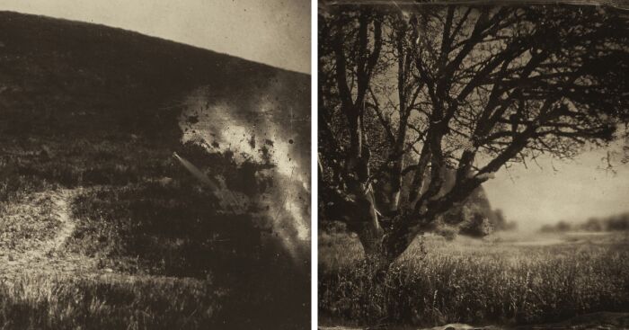
On the morning of February 22nd, 1856, U.S. Indian Agent George H. Ambrose carried out his orders from General Joel Palmer to forcefully remove and march several hundred indigenous men, women, and children from their aboriginal homeland in Southern Oregon to a Reservation in the Mid-Willamette Valley 263 miles away. This thirty-two-day journey was filled with deceit, suffering, death, and murder.
This project started with several years of preparation and research, reading through thousands of historical letters, looking over old survey maps from the 1850s, and utilizing satellite imagery from today. I retraced the entire route and I was able to locate bygone roads that are no longer in existence while following others that are still here today. I made these photographs using an antique wooden view camera and the wet plate collodion photo process from the 1850s and paired them with the journal entries written in the same time period. These landscape photographs illustrate the fraught expedition that Ambrose detailed in his daily journal. The imperfect photos play off the serendipitous technical flaws to create ghostly images that echo the grim history of the past and capture the forgotten and seldom told story of Oregon’s “Trail of Tears.”
More info: nolanstreitberger.com | Instagram
Wednesday, March 12th, 1856.
“Cloudy and threatening rain. We had some trouble in finding our cattle. We however succeeded in getting them to gather about ten o’clock. After traveling through a canyon about one and a half miles we arrived at Calapooia Creek. Our route lay directly up the creek for two and a half miles over hilly but prairie country where we crossed the steam on a bridge at Baker’s Mill. For the remainder of the day our route lay northward and over some steep hills. About four miles from the mills we struck camp at what is called Oakland. Two deaths occurred today since we camped, one man and one woman.”
~ George H. Ambrose, Indian Agent.
Friday, March 14th, 1856.
“Cloudy and showery. By keeping our cattle in pasture we were enabled to get an early start. Our route lay down Elk Creek through a rough canyon which we found quite muddy. We crossed Elk and Pass creeks and several other streams. After crossing Pass Creek our road lay immediately up the creek and bounded by high mountains on either side. We drove eight miles today and camped at the foot of the Calapooya Mountains.”
~ George H. Ambrose, Indian Agent.
Monday, March 17th, 1856.
“This morning we took up our line of march in a northward direction. The roads were quite hilly and places very muddy. This morning while crossing a small steam a teamster broke a wagon tongue, which delayed us an hour to repair, after which we proceeded without any further difficulty for the remainder of the day. We encamped tonight on the west bank of Rich Creek, a distance of thirteen miles from where we started. Arrived in camp by four o’clock.”
~ George H. Ambrose, Indian Agent.
Tuesday, March 18th, 1856.
“Cloudy and threatening rain. During the night an Indian died, which delayed us a short time to bury, however by nine o’clock, we were in readiness to start. We traveled over a level flat country, in places quite muddy. The greatest difficulty we experienced is in obtaining grass for our cattle, which we find to be exceedingly scarce. We drove today a distance of twelve miles. Camped on an oak grove near the claim of Mr. Smith.”
~ George H. Ambrose, Indian Agent.
Wednesday, March 19th, 1856.
“Cloudy and threatening rain. Quite showery through the day. We continued our march down Long Tom and passed over some very muddy roads. We traveled today a distance of fourteen miles and encamped on the bank of the Long Tom at Starrs Point.”
~ George H. Ambrose, Indian Agent.
Thursday, March 20th, 1856.
“The weather still continues cloudy and threatening rain. We secured a good pasture last night for the cattle and this morning quite early were underway. Our route lay immediately down Long Tom over a level prairie country. In consequence of recent rains our wagons dragged along heavily all day. We drove a distance of fifteen miles and encamped on the bank of Mary’s River at the ferry. A very hard days drive but no camp could be found short of this.
~ George H. Ambrose, Indian Agent.
Friday, March 21st, 1856.
“Clear and pleasant. This morning we were two or three hours in ferrying the river. For two or three miles we found the roads very muddy. About three miles north from Corvallis our road improved very much, becoming rolling and dry. We traveled today a distance of twelve miles and encamped near the claim of Mr. Reed.”
~ George H. Ambrose, Indian Agent.
Saturday, March 22nd, 1856.
“Cloudy weather again. This morning for several miles our road was in excellent condition. We then found some very bad road and sloughy prairie to cross over after which we arrived at the South Luckiamute, which we crossed on a bridge. Still continued our course northward, in a few miles we arrived at the Little Luckiamute, which we also crossed on a bridge and passed upon the north bank of the steam a short distance and encamped near a little oak grove. Traveled twelve miles.”
~ George H. Ambrose, Indian Agent.
Monday, March 24th, 1856.
“Got an early start this morning and had an excellent road. We drove a distance of fifteen miles and encamped near Mr. Frederick’s.”
~ George H. Ambrose, Indian Agent.
Tuesday, March 25th, 1856.
“Clear and pleasant. We got an early start this morning and after driving hard all day reached the reservation about four o’clock in the evening, after driving a distance of sixteen miles. So ends my journey and journal after a period of thirty-three days, in which time we traveled a distance of two hundred and sixty-three miles. Starting with three hundred and ninety-five Indians. Eight deaths and eight births, leaving the number the same as when started.
Yours respectfully,
G.H. Ambrose
Ind. Agt.”
~ George H. Ambrose, Indian Agent.
282views
Share on Facebook


 No fees, cancel anytime


20
0