Get Premium
Dark mode theme is available exclusively for premium users. Learn more about the benefits of subscribing.
No fees, cancel anytime.

 Dark Mode Ad-Free Browsing Unlimited Content
 Ad-Free Browsing Unlimited Content Dark Mode
Join 1.2 million Panda readers who get the best art, memes, and fun stories every week!
In ancient times, when the vast majority of people never left their hometowns and villages and learned about the world around them solely from the tales and legends of travelers, many incredible myths about distant lands arose.
The world in the stories of ancient storytellers was simultaneously frightening and enchanting, full of wonders and dangers… and, in fact, that’s exactly how it remains today. Don’t believe it? Then let’s explore this collection of incredible geographical facts, made for you by Bored Panda!
This post may include affiliate links.

 Pad Thai was an invention of the Thai government specifically because they didn't have a well known national dish.
 Canada has more lake than the rest of the world COMBINED
I mean, you just have to take a look on a map, but this still always baffles me...
 Indonesia has a volcano called Kawah Ijen where sulfuric gas burns into electric blue fire at night. Feels like someone modded Earth.
There are numerous threads online encouraging netizens to share the most unexpected and non-obvious facts about countries and places on our planet that they know. Many of these facts are nothing more than outdated myths, but some are true, though still very hard to believe.
 There is an island in a river between france and spain that is governed 6 months at a time by each nation taking turns in administration. Meaning the border moves constantly according to the season
It's always nice to share. Maybe something Trump could learn from.
 Canada has so many lakes (over 2 million) we’ve run out of names.
 If you placed Alaska on top of the continental United States, it would stretch from coast to coast, mercilessly crushing everything beneath.
Of course, a significant portion of these facts is simply an attempt to view something familiar from a different perspective. For example, Alaska is indeed, geographically, both the westernmost and easternmost US state. This is because part of the Aleutian Islands, which belong to Alaska, extends into the Eastern Hemisphere.
Consequently, these several islands actually lie at the easternmost point of the Earth’s Eastern Hemisphere. Incidentally, the International Date Line also runs nearby, which, if you recall, a century and a half ago, won Phileas Fogg his famous bet to travel around the globe in 80 days…
 Oxford university is older than the Aztec Empire.
 Mexico has four time zones and also has a glacier.
Actually six time zones. The parts along the US border observe DST, while the rest of the country doesn't.
 Ethiopia is currently in the year 2018. They use a different calendar to the rest of the world, which also has 13 months instead of 12.
Another classic example of a paradoxical fact is how two countries, whose mainlands are separated by thousands of miles, actually share a border. And this is all due to the various overseas possessions of these countries. For example, France has several departments in South America and, accordingly, a common border with Brazil, or one tiny island in the North Atlantic that borders Canada.
Or, say, Spain, which can de facto be considered not only a European but also an African state, because it has two enclaves located in North Africa: Ceuta and Melilla. Yes, after several centuries of Western European monarchs redrawing the world map at will, numerous weird geographical paradoxes related to borders still remain nowadays…
 The deepest lake in the US is in Oregon but it has NO tributaries and is one of the cleanest bodies of water in the world.
 More people live in the city of San Francisco than live in the state of Wyoming
Physical geography also yields many absurd and interesting facts. For example, the Isthmus of Panama, where you can see the sun rising in the morning over one ocean and setting in the evening over another. Yes, at its narrowest point, the Isthmus of Panama is about 30 miles wide, so this is entirely possible.
The fact that cities in the far east of Brazil are actually closer to West Africa than to Brazil's western border shouldn't surprise you too much. Firstly, Brazil is among the top 10 countries in the world by area.
Secondly, if you look at a world map, Brazil's east coast sometimes looks "torn away" from the Gulf of Guinea in West Africa. In fact, millions of years ago, this was indeed the case, and once, during the age of dinosaurs, they were parts of a single gigantic continent.
 Turkey has a city called Batman. Canada has a heritage site called Head-Smashed-In-Buffalo-Jump. Also a town called D***o.
England has lots of weird and "rude" place names. Shitterton, Cockermouth, Bell End, Wetwang, Bitchfield, Fingeringhoe, Penistone. In the Middle Ages, street names would often be named after the trade that could be found there, so a lot of streets which were frequented by "ladies of the night" were called Gropecunt Lane. There are no streets called that now, but there's a Grope Lane still left in Shrewsbury.
 That Iceland is literally being torn apart in real time because it sits right on top of the gap between two shifting tectonic plates, the resulting volcanic activities is also why that island exists in the first place.
Or, take the unique characteristics of India, where you can find literally any climate, from desert to mangrove forests to staggering heat to perpetual snow and cold. Firstly, India is vast – its area is three times that of Western Europe.
Secondly, it’s actually a subcontinent, which until relatively recently (from a geological perspective, of course), 55 million years ago (by which time, for example, dinosaurs had already become extinct), was a separate continent. Then, as a result of a massive collision with the Eurasian lithospheric plate, the also "very young" Himalayas emerged.
 The Himalayas are the youngest mountain range and they are still pushing upwards north in a continental collision between Asiatic plate and the Indian subcontinent
Nanga Parbat in the western Himalayas is the fastest growing nonvolcanic mountain in the world, growing taller at a rate of 7 mm per year. That's 7 metres in 1,000 years, 7 kilometres higher in a million years (oops).
 Ireland, while slightly smaller than Illinois, has ancestry claim on 31million US citizens.
Fellow spawn of the Emerald Isle - When you visit there, it's "I'm of Irish descent", not "I'm Irish". Please.
 The shortest land border in the world is 80 metres, between Spain and Morocco
By and large, every fact we’ve shared with you in this collection has its own unique story or explanation, which is sometimes more bizarre than all the fiction and gossip of ancient travelers. But these facts are 100% true, even though they sound fake and like outright fabrications.
So now the only thing we want from you is to actually read all these facts, and maybe share some more incredible pieces of knowledge about various places on Earth, distant or not, that you know and believe are truly worth sharing.
 Canada has the smallest desert in the world.
andrea.j.phillips reply:
Embarassing...
 Australia is the driest inhabited country on earth. It also has the world’s largest underground water supply.
 Australia’s coastline (including Tasmania, but not other surrounding islands) is 35,877 kilometres (22,292 miles). It has more than 10,000 beaches and if you visit one a day it will take almost 30 years to see every one
Australia has a startlingly large number of small islands, 8,222 islands. Most of them in the Kimberley region. Another large number near Esperance. Fewer around Tasmania and in the Great Barrier Reef. Most Australians couldn't name more than about 30 of them.
 India is the smallest country in the world to have:
1. All major ecosystems: forests, grasslands, deserts, tundras, and aquatic ecosystems
2. All climatic conditions: Tropical, Dry, Temperate, Continental and Polar
3. All major forests: Tropical Forests (Evergreen & Semi-Evergreen , Deciduous, Thorn & Scrub) , Subtropical Forests (Broad-leaved & Pine, Dry Evergreen) , Temperate Forests , Alpine & Sub-Alpine Forests and Littoral & Swamp Forests i.e. Mangroves
 Budapest is called Budapest, because when the original Pestbuda or Pest-Buda (alternatively Ofenpesth) name was put on the map, the names would’ve been on the “wrong”, i.e. opposite sides of the Danube.
 In Panama, you can see the sun rise from the Pacific Ocean and set into the Atlantic Ocean 😅
And no, I am not confusing east and west or something. Look at a map at think it through for a minute ;)
There's a bit that sticks down. Go there, look east for the sunrise, the body of water is the Pacific (with the Atlantic beyond). Now go to the bit that sticks up, and so the same thing in reverse for sunset.
 The oldest rocks on earth (3+ billion years ) are in the Canadian Shield.
Hmm... 'Archean rocks are exposed on Earth's surface in very few places, such as in the geologic shields of Canada, Australia, and Africa'. One of rocks brought back from the Moon by Apollo 14 turned out to be a rock from Earth (!) of about the same age as the oldest Earth rocks found on Earth. Link follows.
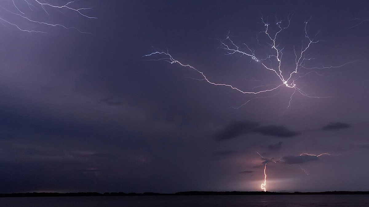
 The catatumbo lightening or forever storms. There is a place in Venezuela where a single, magical storm has been raging for thousands of years. Its breathtaking to watch and local legend says the flashes are actually billions of fireflies.. ⚡️
 Argentina is three times the size of Texas. You could fit all of Western Europe inside Brazil. João Pessoa, Brazil is closer to Dakar, Senegal than it is to most of the other capitals of South America. France’s longest border is with Brazil.
An American told a Brit "You know, you could fit your whole country into Nebraska." He replied "Yes, but why would I want to?"
 Alaska is the eastern most state by longitude.
It’s also the northern and western most state.
It would take you everyday for 29 years to visit every beach in Australia. Challenge accepted.
 disney world is so huge that you can fit 51 disney lands inside of it
There is a city underneath. It has mechanical and electrical things that run the park in it.
Even many of those I had heard of before were still fun.
Load More Replies...Spain is in the WET time zone, but in 1940 they changed their time to go forward one hour and be on CET time to align with N**i Germany. After the war they never changed back. So technically, everyone in Spain has the wrong time. 😆
What surprised me about the south of Spain was how quickly day becomes night. In the Guildford it sort of fades away slowly, but in Málaga it is more like "okay, we're switching to night mode now". Sorry, I meant "¡Vamos todos a modo nocturno!" (it just sounds better in Spanish, doesn't it?).
Load More Replies...Even many of those I had heard of before were still fun.
Load More Replies...Spain is in the WET time zone, but in 1940 they changed their time to go forward one hour and be on CET time to align with N**i Germany. After the war they never changed back. So technically, everyone in Spain has the wrong time. 😆
What surprised me about the south of Spain was how quickly day becomes night. In the Guildford it sort of fades away slowly, but in Málaga it is more like "okay, we're switching to night mode now". Sorry, I meant "¡Vamos todos a modo nocturno!" (it just sounds better in Spanish, doesn't it?).
Load More Replies...


 No fees, cancel anytime