ADVERTISEMENT

Numbers and geography. Neither, as my family never tires of pointing out, is exactly my strong suit. A spreadsheet? My eyes glaze over instantly. Need directions? You’re better off staying home than listening to me. Maps, however, are a bit of a different story. Maybe it’s because a good map does the hard work for you. Take a pile of data that would normally send me running, add a few colors, and suddenly order is restored to the world (or at least the part of it on the map). And it’s not all navigation, either.

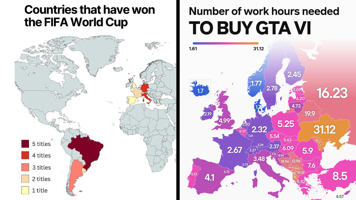
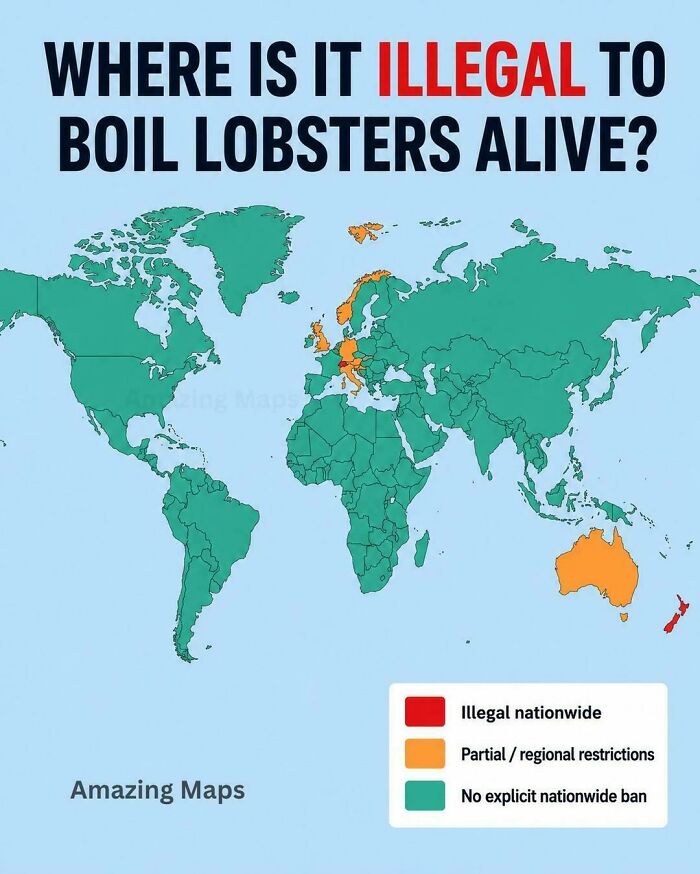
Turns out some maps even reveal all sorts of curiosities you never knew you wanted to know about, like which European countries use a comma instead of a decimal point, where it’s illegal to boil a lobster alive, or how many hours you’d have to work to buy GTA VI, depending on where you live. So whether you’re a geography buff or someone who, like me, still gets lost on the way to the shops, here are some of the most fascinating maps out there, plus some expert insight from Philippa Irvine, a geography lecturer at Rhodes University in South Africa.

#1

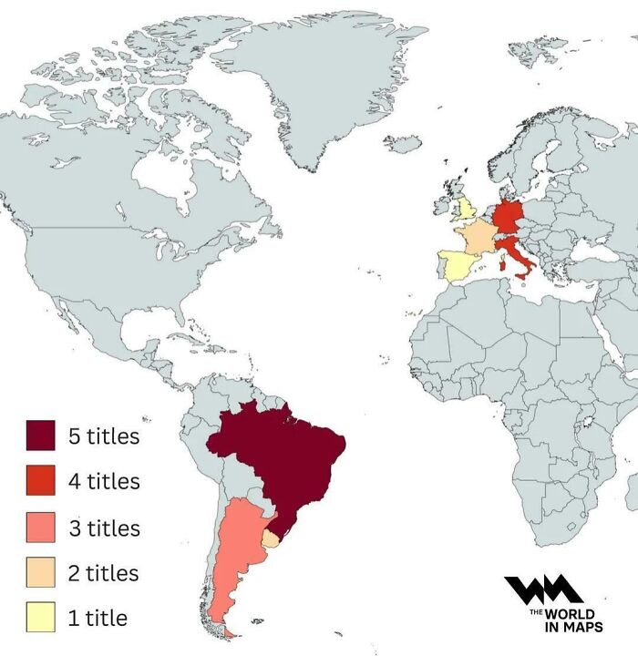
Countries That Have Won The FIFA World Cup

A world map showing global sports titles won by country to explain the world.

vladgrinch Report

RELATED:
    #2

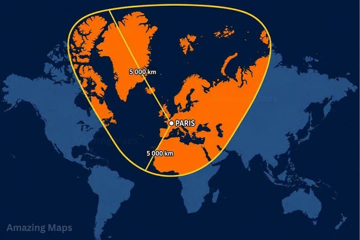
    What A 5,000 Km Radius Around Paris Looks Like On A Mercator Map

    A world map featuring a highlighted five-thousand-kilometer radius centered on Paris.

    vladgrinch Report

    #3

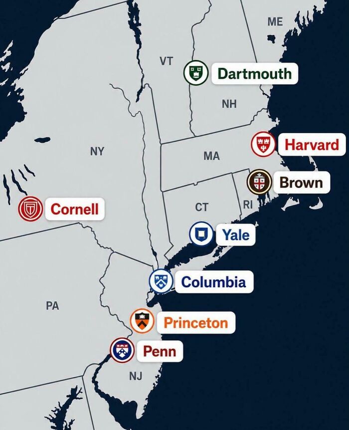
    The Locations Of America's Ivy League Universities

    A map showing locations of Ivy League universities in the northeastern United States.

    vladgrinch Report

    #4

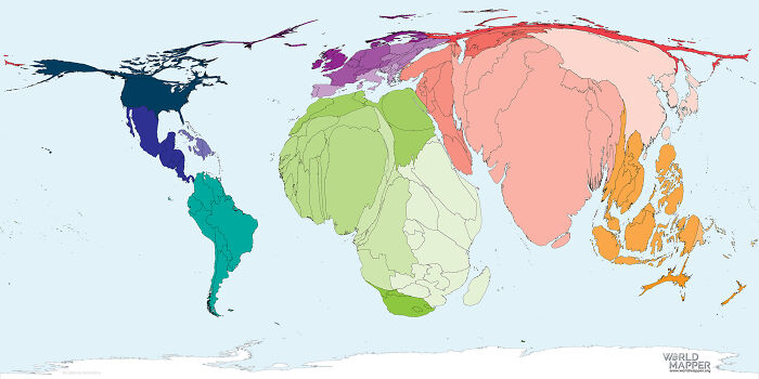
    World Map By Total Number Of Births

    A distorted world map showing global land mass scaled according to specific data sets.

    julius-ceaser100 Report

    ADVERTISEMENT
    #5

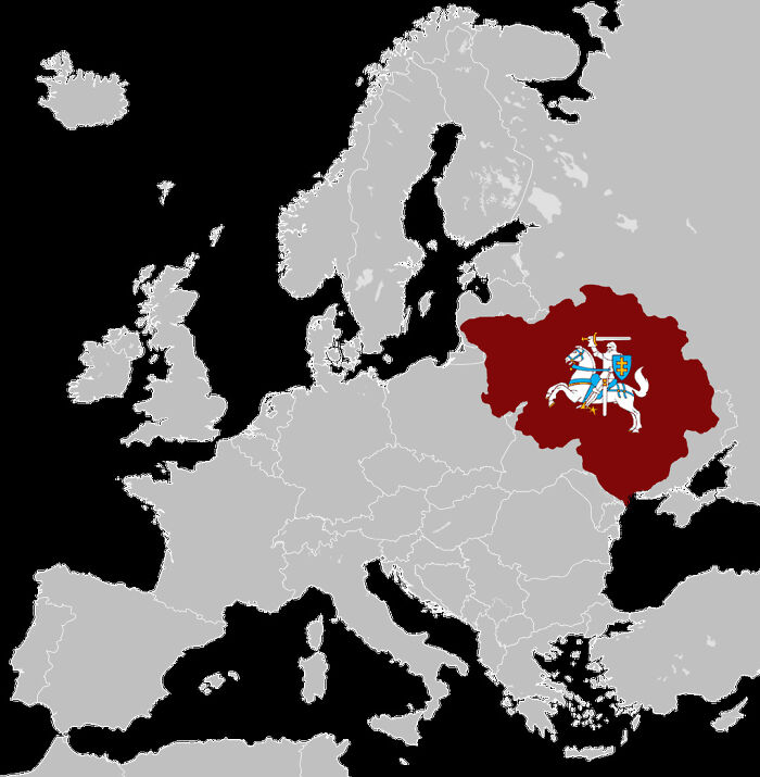
    Lithuania At It's Historical Peak (15th Century) Also Known As Grand Duchy Of Lithuania, It Expanded Up To 900,000-100,000 Sq Km

    Fascinating maps that explain the world showing historical map highlighting Grand Duchy of Lithuania in Europe.

    banamkae Report

    ADVERTISEMENT
    #6

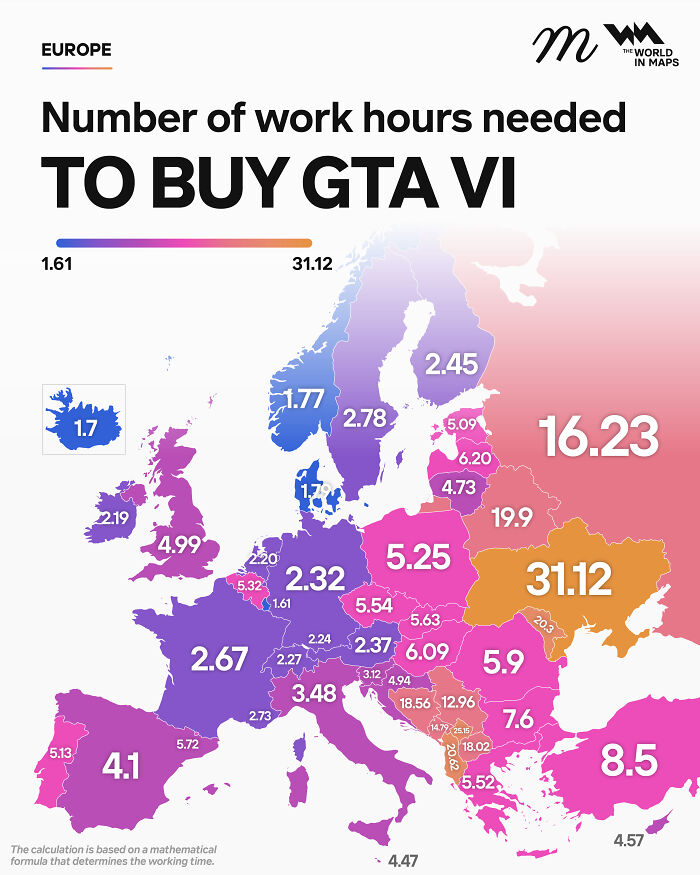
    Number Of Hours Needed To Buy GTA VI

    Fascinating maps that explain the world showing work hours needed to buy GTA VI across European countries.

    maven_mapping Report

    #7

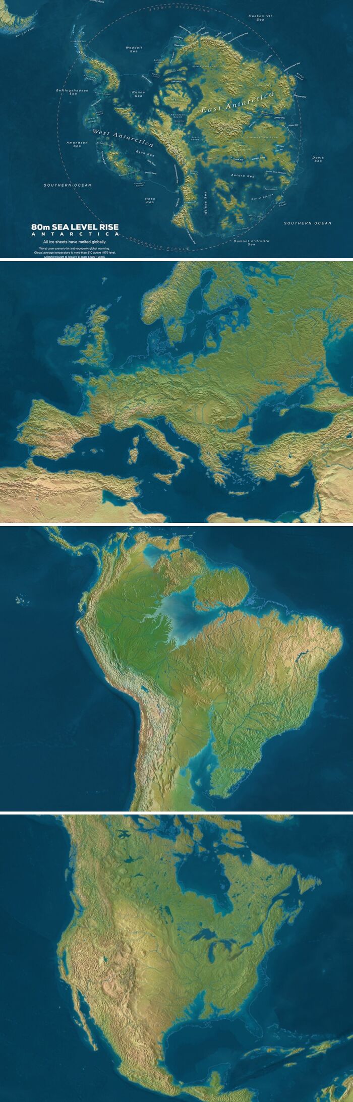
    Sea Level If All Ice Would Melt

    Fascinating maps that explain the world showing global coastlines with an 80m sea level rise scenario.

    Ok_Bake_4761 Report

    #8

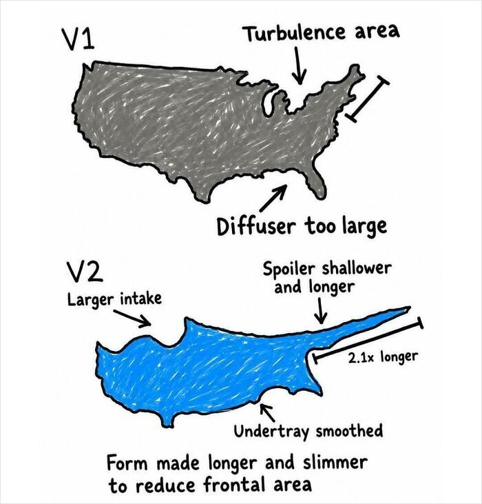
    Cyprus Is Just A More Aerodynamic Version Of The USA

    Fascinating infographic comparing aerodynamic shapes of the USA and Cyprus to explain aerodynamic principles.

    FunWithChaos0x Report

    ADVERTISEMENT
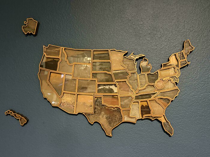
    #9

    I Made A Map Of The United States Using Actual Soil From All 50 States

    Wooden map of the United States filled with actual soil samples collected from every single state.

    AMLT1983 Report

    ADVERTISEMENT
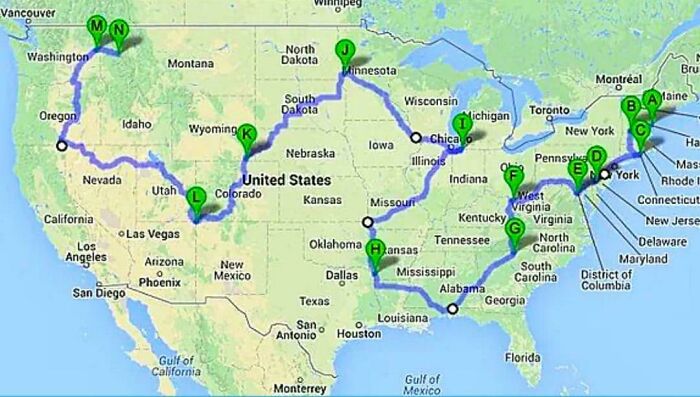
    #10

    The Shortest Driving Route Through All 48 Contiguous US States

    A map of the United States displaying a complex road trip route across various states.

    vladgrinch Report

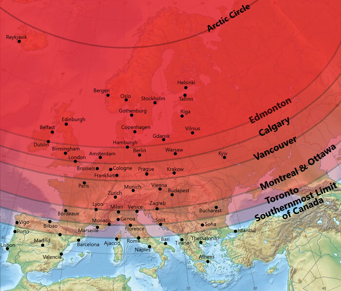
    #11

    Canada vs. Europe Latitude (Oc)

    A map comparing European latitudes with major Canadian cities to better understand world geography.

    Aijol10 Report

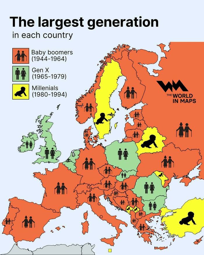
    #12

    The Largest Generation In Each Country

    Demographic map of Europe displaying the largest generation in each country.

    vladgrinch Report

    ADVERTISEMENT
    #13

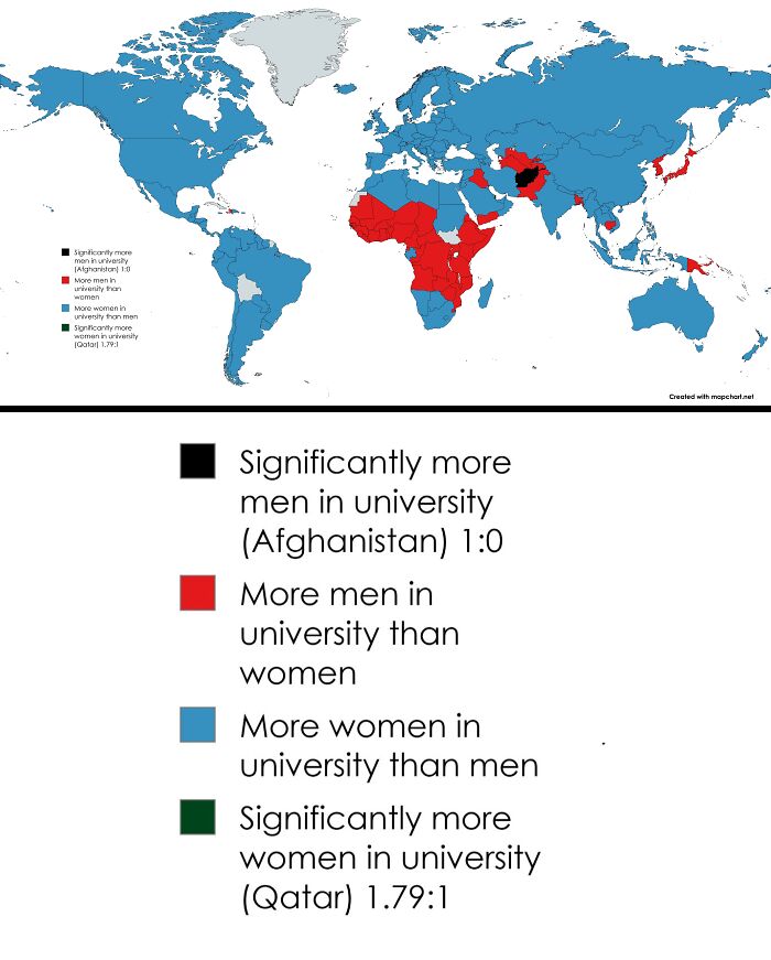
    Countries By How Many Women Attend University Education Compared To Men

    Educational world map showing gender ratio in universities worldwide.

    AntiqueBrick7490 Report

    ADVERTISEMENT
    #14

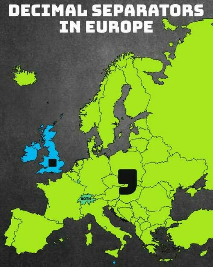
    Decimal Separators Used In Europe

    A color-coded map showing the distribution of decimal separators used across European countries.

    vladgrinch Report

    #15

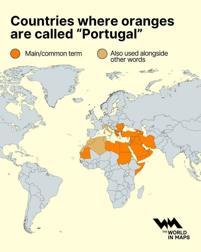
    Countries Where Oranges Are Called ''portugal''

    A global map illustrating countries where oranges are called Portugal.

    vladgrinch Report

    Never miss a story that brings joy to the world. Add us on Google

    #16

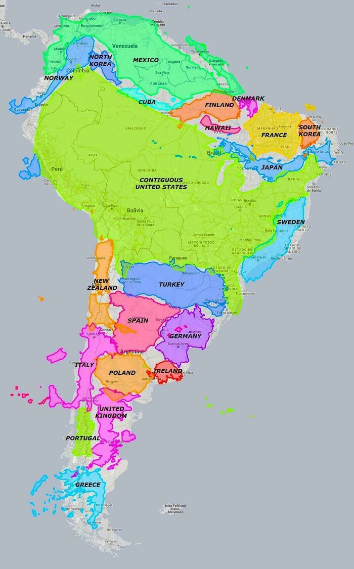
    South America Is Much Bigger Than Most People Realize

    Fascinating maps comparing the size of South American countries to other nations.

    vladgrinch Report

    ADVERTISEMENT
    #17

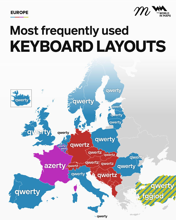
    Most Frequently Used Keyboard Layouts In Europe

    Fascinating maps of Europe highlighting the most frequently used keyboard layouts by country.

    maven_mapping Report

    ADVERTISEMENT
    #18

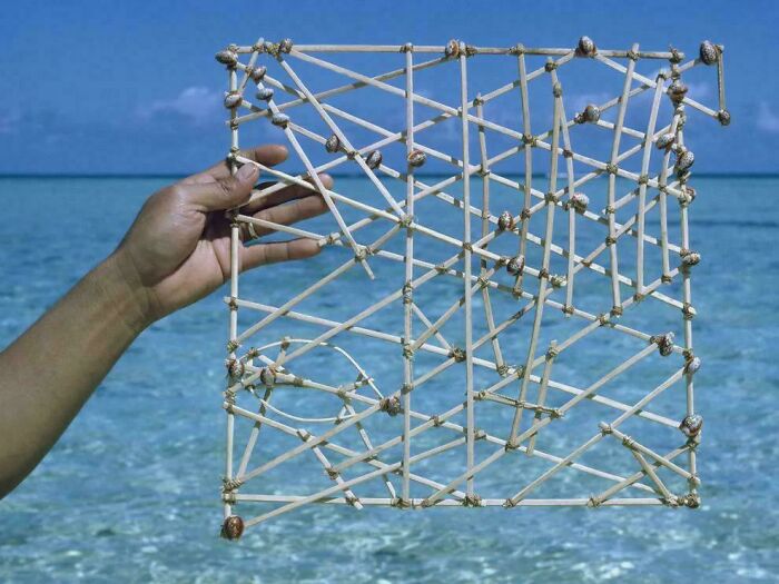
    Polynesian Shell Map

    A hand holding a traditional wooden Marshallese stick chart used for ocean navigation against the sea.

    StephenMcGannon Report

    #19

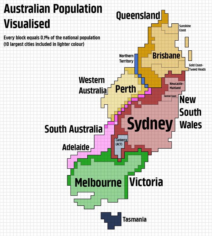
    Australian Population Visualised

    A pixelated map displaying Australian population density across regions and major cities.

    KaleyTheKing Report

    #20

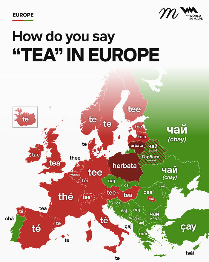
    How Do You Say "Tea" In Europe

    An informative map showing how to say the word tea in various European languages.

    maven_mapping Report

    ADVERTISEMENT
    #21

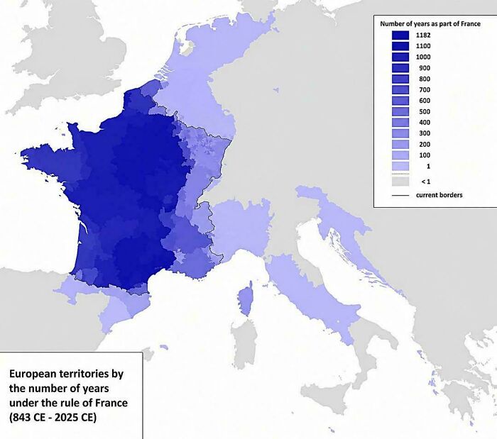
    How Long Different Parts Of Europe Were Ruled By France

    Historical map showing European territories under French rule over centuries to explain the world.

    vladgrinch Report

    ADVERTISEMENT
    #22

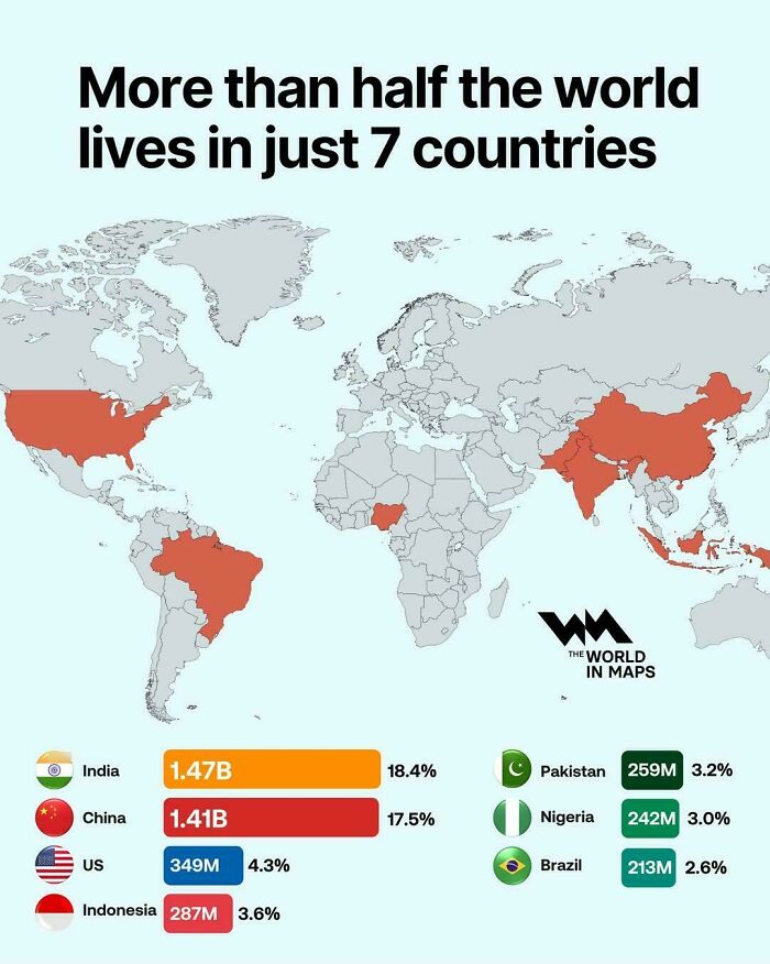
    More Than Half Of The World Lives In Just 7 Countries

    Global population map highlighting seven most populous countries, example of fascinating maps.

    vladgrinch Report

    #23

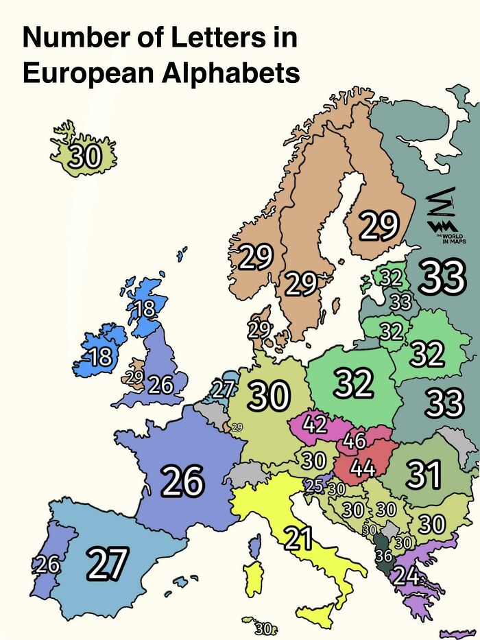
    Number Of Letters In European Alphabets

    A map showing letter counts in European alphabets as part of fascinating maps that explain the world.

    vladgrinch Report

    #24

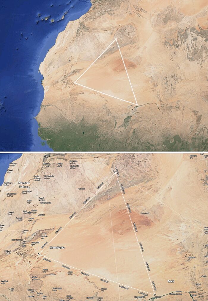
    This Big Triangle In West Africa Is Completely Devoid Of Humans. No Towns Or Settlements. More Than 1/5 Of Mauritania's Land Area Is In This Triangle

    Satellite map outlining a massive geometric triangle drawn across the Sahara Desert in Africa.

    SuspiciousUse6 Report

    ADVERTISEMENT
    #25

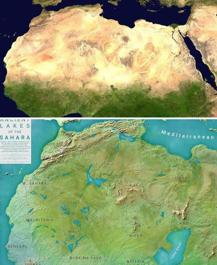
    The Sahara Today vs. 8 Thousand Years Ago

    Side by side satellite maps comparing current desert Sahara to ancient green lakes region.

    Fokabaszo_Fingbag Report

    ADVERTISEMENT
    #26

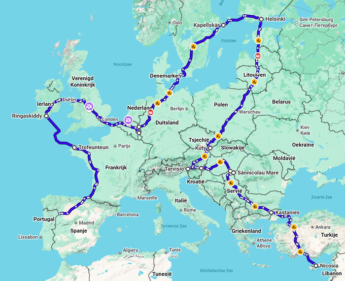
    The Shortest (Fastest) Road Trip Visiting All EU Countries, Find The Errors

    A map of Europe displaying an extensive driving route across multiple countries.

    Sad-Pop6649 Report

    #27

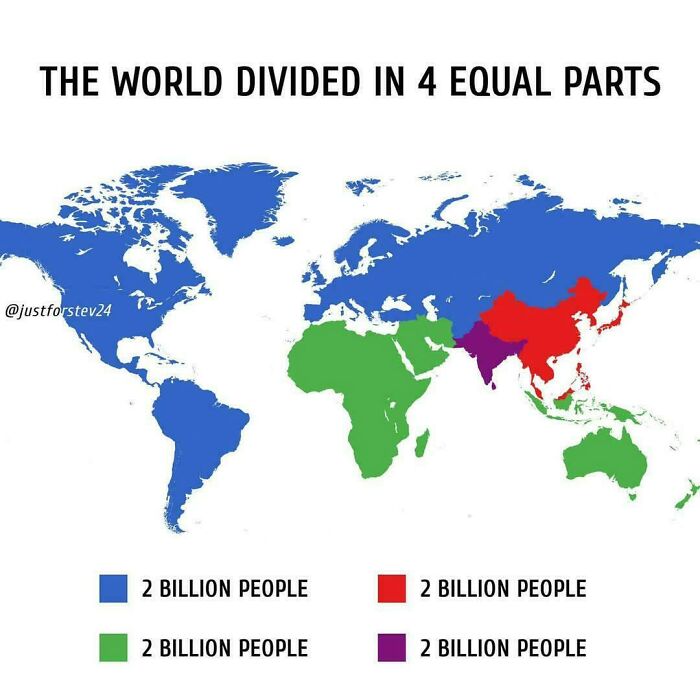
    World Blocks By Population (2b Each)

    A map dividing world population into four equal regions of two billion people each.

    aNonYmoUs_gLideR Report

    #28

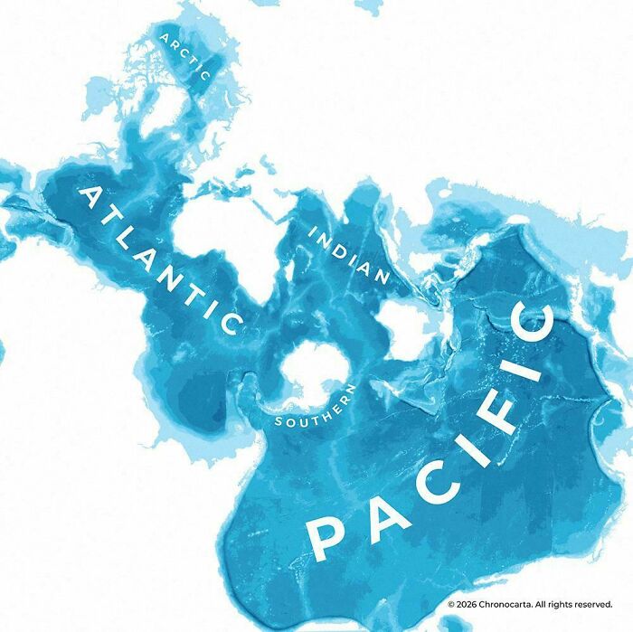
    Spilhaus Projection Is One Of The Most Interesting Ones To Map The World's Oceans

    A unique map that explains the world oceans centered around the South Pole.

    RatioScripta Report

    ADVERTISEMENT
    #29

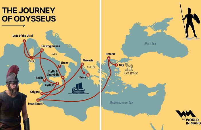
    The Journey Of Odysseus

    A fascinating map illustrating the mythical journey of Odysseus across the Mediterranean Sea.

    vladgrinch Report

    ADVERTISEMENT
    #30

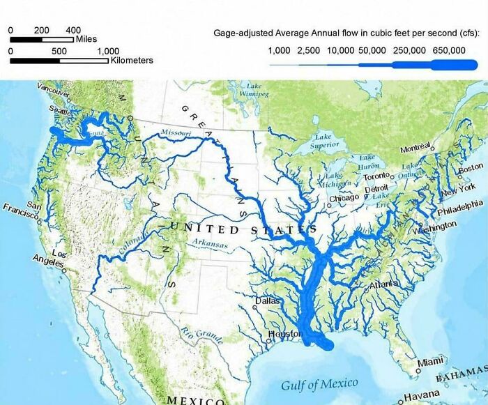
    US Rivers Drawn In Proportion To How Much Water They Carry

    A map illustrating average annual river flow volume across the United States

    vladgrinch Report

    #31

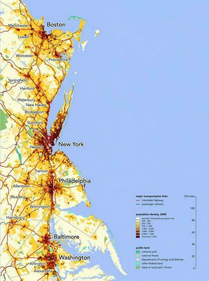
    The Northeast Megalopolis, Where A Sixth Of Americans Live

    Population density map of the US East Coast showing fascinating maps of urban corridors from Boston to Washington DC.

    vladgrinch Report

    #32

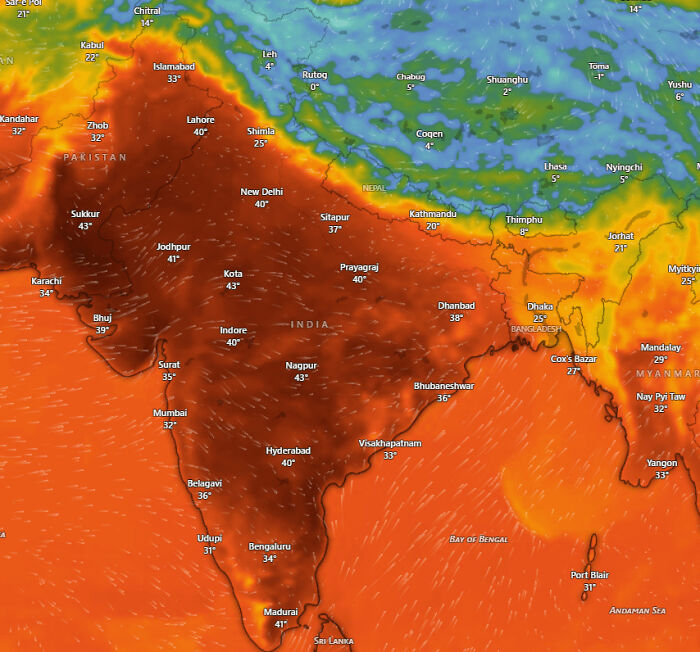
    A Map Of The Temperatures South Asia Is Facing Right Now. It's So Hot That I Can't Even Stand Outside For Over 10 Minutes In The Afternoon

    Detailed heat map showing temperatures across India and South Asia that explain the world better.

    Asleep_Phone3087 Report

    ADVERTISEMENT
    #33

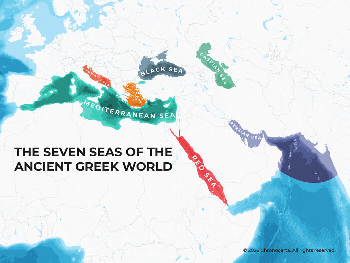
    Map Of The Seven Seas In Greek Sources

    Historical map illustrating the seven seas of the ancient Greek world to explain the world better.

    RatioScripta Report

    ADVERTISEMENT
    #34

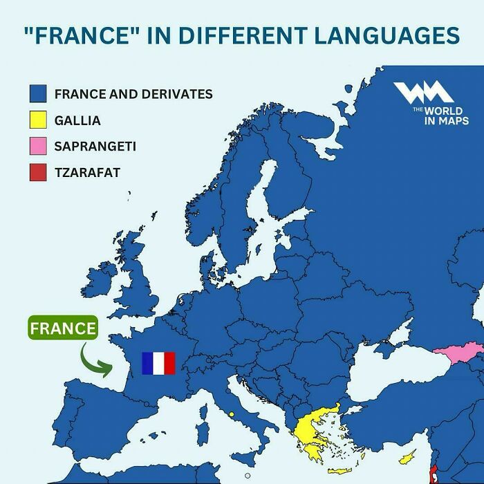
    "What Do You Call France?" ("France" In Different Languages)

    European map displaying how France is named in different languages that explain the world better.

    SOHONEYSAME Report

    #35

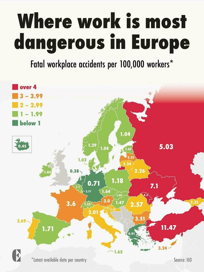
    Where Work Is Most Dangerous In Europe

    Color coded map showing fatal workplace accidents rate in Europe that explain the world better.

    vladgrinch Report

    #36

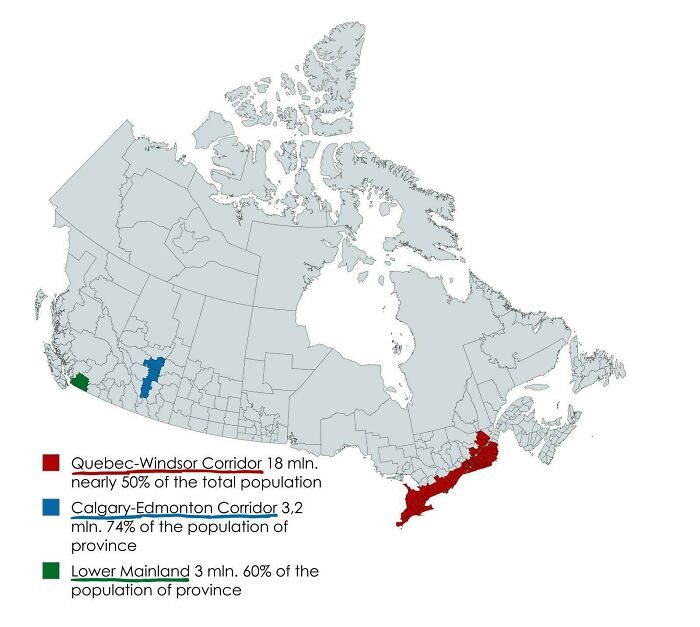
    70% Of Canada's Population Lives In These Three Regions

    Fascinating maps highlighting population densities and major corridors in Canada.

    Youtubegoy229 Report

    ADVERTISEMENT
    #37

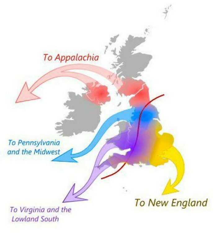
    The Migration Routes From Britain That Shaped Early America

    Fascinating maps showing historical migration patterns from Great Britain to North America.

    vladgrinch Report

    ADVERTISEMENT
    #38

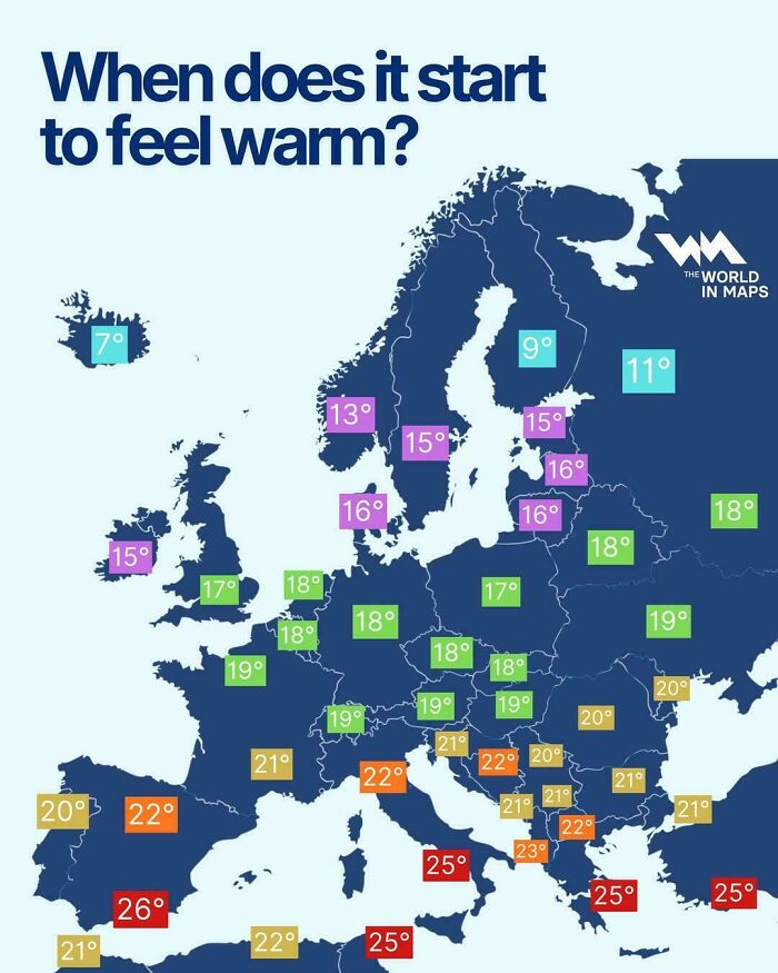
    When Does It Start To Feel Warm?

    Fascinating maps of Europe displaying regional temperatures at which people consider it warm.

    vladgrinch Report

    #39

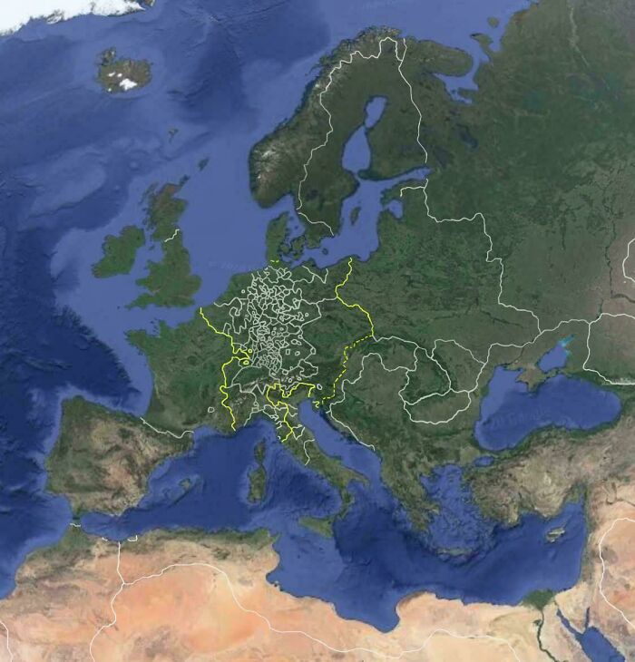
    Europe On Google Earth, But It's The 17th Century

    A satellite map of Europe showcasing the Holy Roman Empire outline, one of many fascinating maps.

    tightypp Report

    #40

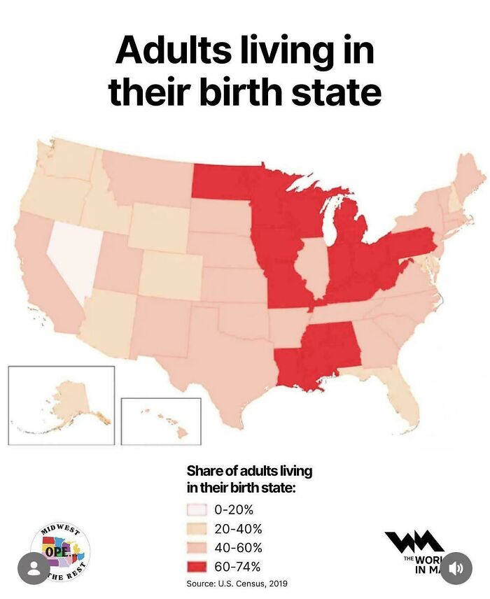
    Adults Living In Their Birth State (US)

    US map showing the percentage of adults living in their birth state.

    cardamomroselatte Report

    ADVERTISEMENT
    #41

    The Countries That Have Banned Boiling Lobsters Alive

    World map illustrating laws on boiling lobsters alive by country.

    vladgrinch Report

    ADVERTISEMENT
    #42

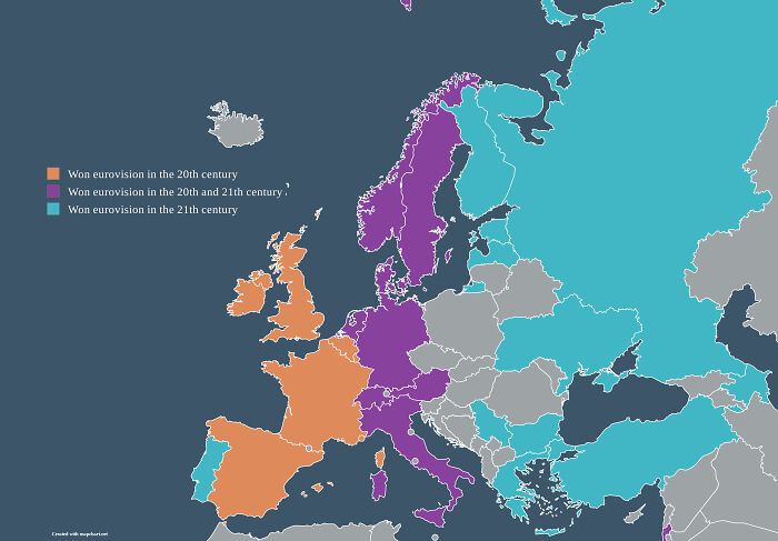
    Countries That Have Won Eurovision, Split By Century

    A map of European countries color-coded by the century they won the Eurovision Song Contest.

    Nearby-yourcat Report

    #43

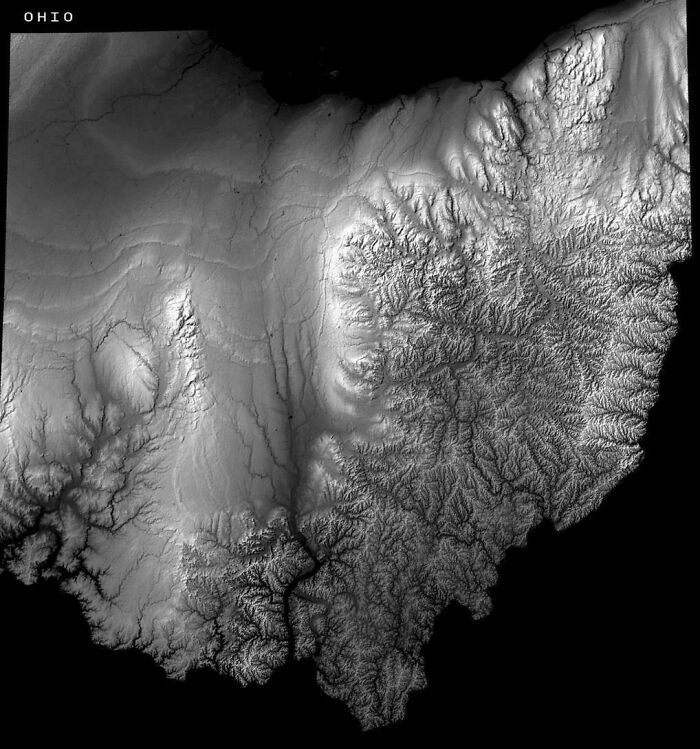
    Ohio's Elevation Map Reveals Where The Glaciers Stopped

    A black and white topographic relief map of Ohio showing terrain variations, serving as a fascinating map.

    vladgrinch Report

    #44

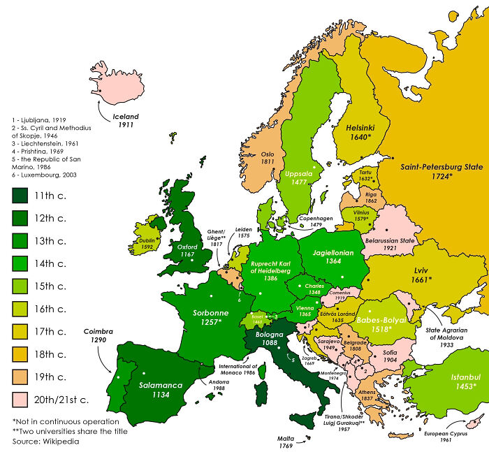
    The Oldest Continuously Operating Universities In Each European Country

    A fascinating map of Europe color-coded by the century in which each country established its oldest university.

    InnerPace Report

    ADVERTISEMENT
    #45

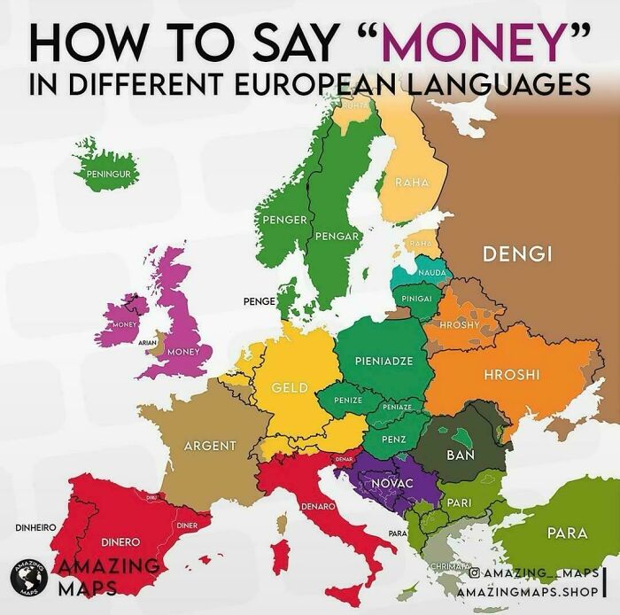
    How To Say Money In Different European Languages

    A color-coded linguistic map showing how to say money across different European countries.

    vladgrinch Report

    ADVERTISEMENT
    #46

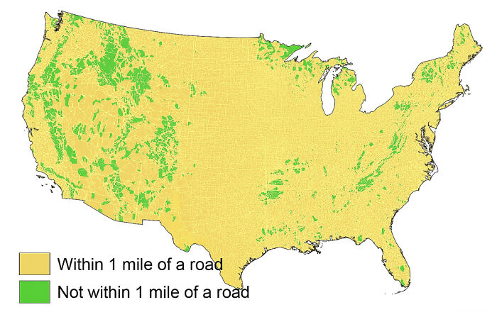
    Lower 48 Area Within 1 Mile Of A Road

    A map of the United States displaying areas within and not within 1 mile of a road.

    medicallymiddleevil Report

    #47

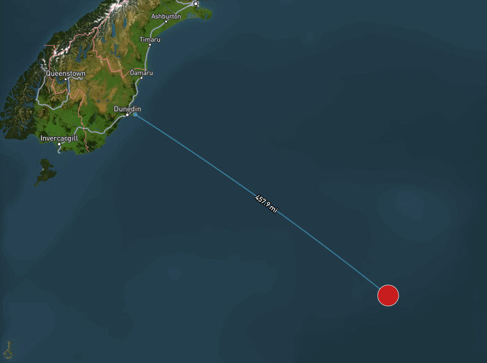
    The Most Isolated Building On Earth

    A map depicting a distance of 457.9 miles in the ocean off the coast of Dunedin, New Zealand.

    mbforr Report

    #48

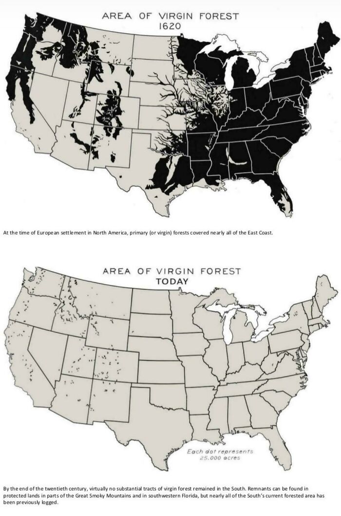
    Area Of US Virgin Forest In 1620 vs. Today

    Comparison map showing the dramatic reduction of US virgin forest area from 1620 to present to explain the world.

    catshifturr Report

    ADVERTISEMENT
    #49

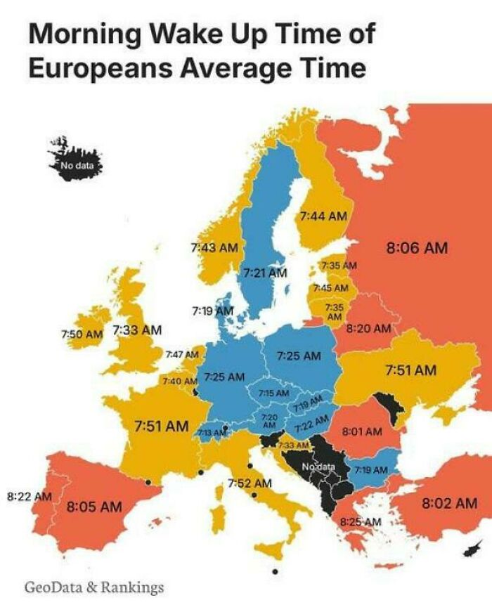
    What Time Do Europeans Typically Wake Up?

    Color-coded map showing average morning wake-up times across European countries to explain the world.

    vladgrinch Report

    ADVERTISEMENT
    #50

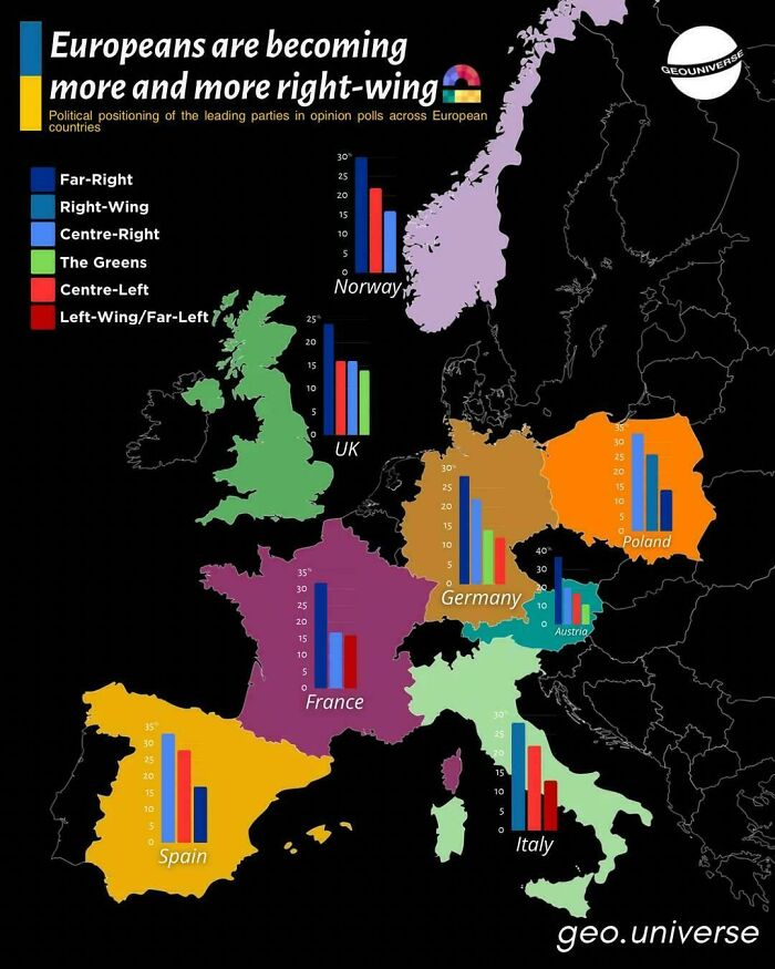
    Europeans Are Becoming More And More Right Wing

    Political map displaying political shifts in Europe to explain the world through data visualization.

    vladgrinch Report

    #51

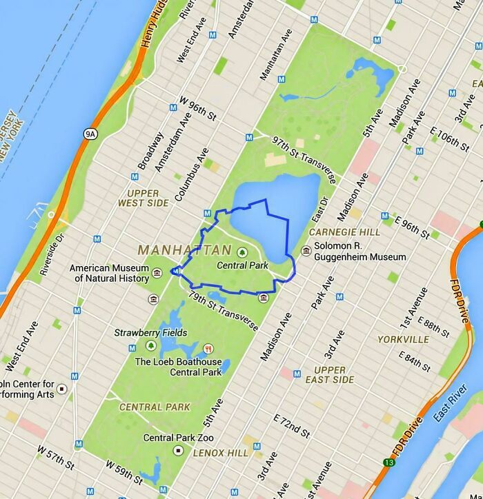
    The World's Smallest Country Compared To Central Park

    Detailed map of Central Park Manhattan illustrating intriguing geographic layouts to explain the world.

    vladgrinch Report

    #52

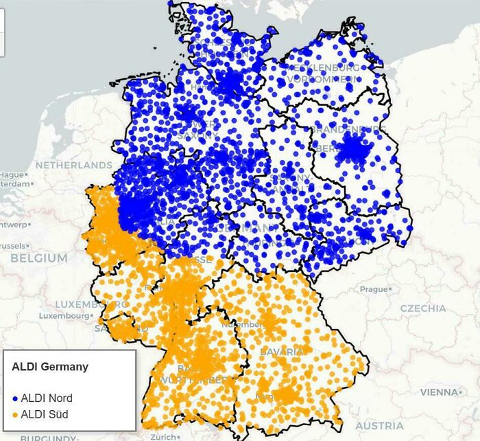
    I Mapped All 4.259 Aldi Locations In Germany (Nord vs. Süd Split)

    Map of Germany showing Aldi Nord and Aldi Sud store distributions from fascinating maps.

    Material-Soggy Report

    ADVERTISEMENT
    #53

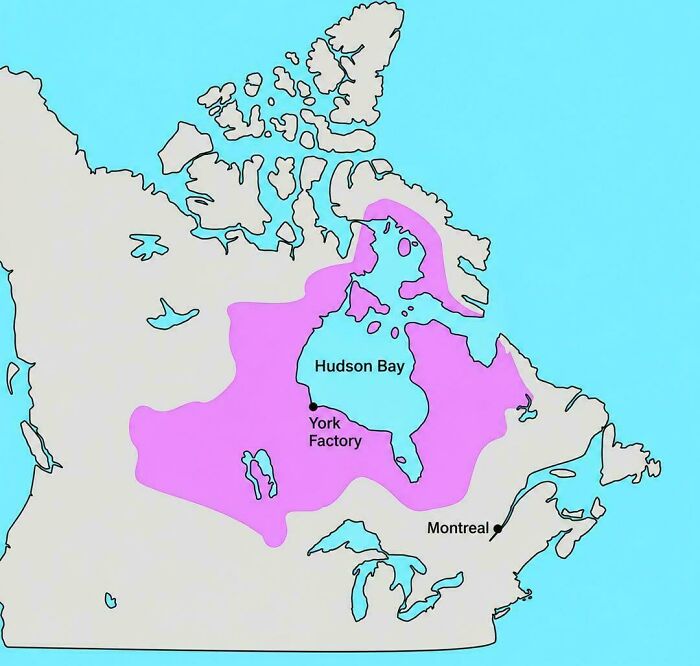
    A Private Company Once Controlled This Much Of North America

    Historical map of North America outlining Hudson Bay territories as one of the fascinating maps.

    vladgrinch Report

    ADVERTISEMENT
    #54

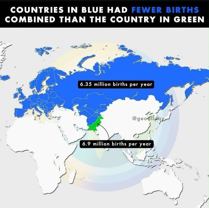
    Birth Rates In Pakistan Are Crazy

    World map showing annual birth rates by country, featured among fascinating maps.

    julius-ceaser100 Report

    #55

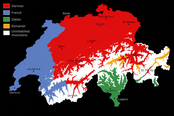
    Language Map Of Switzerland, Excluding Uninhabited Mountains

    Linguistic map of Switzerland displaying language regions, one of many fascinating maps.

    Evilgrandma03 Report

    #56

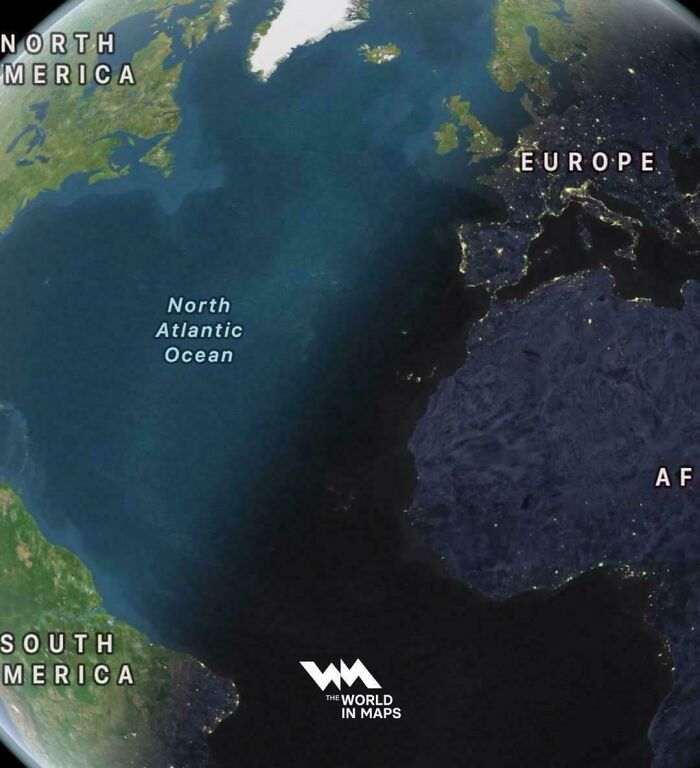
    On The Longest Day Of The Year, The Sun Sets In Eastern Brazil Before Ireland

    Satellite image of Atlantic Ocean night line between continents from fascinating maps that explain the world.

    vladgrinch Report

    ADVERTISEMENT
    #57

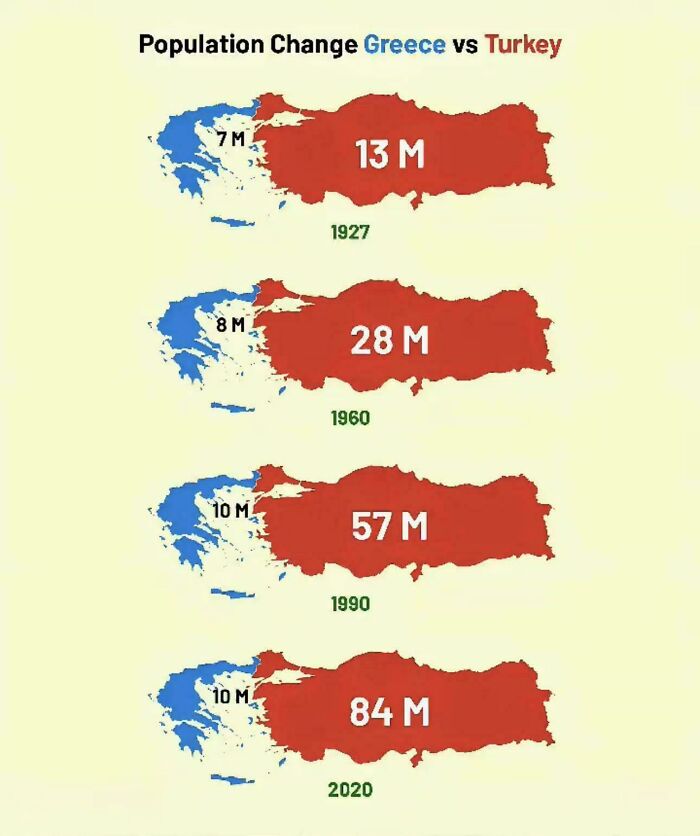
    Population Change In Greece & Turkey Over The Last Century

    Infographic comparing population growth of Greece and Turkey over time among fascinating maps that explain the world.
    Ripamon Report

    ADVERTISEMENT
    #58

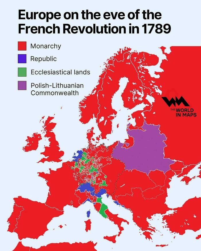
    Europe On The Eve Of The French Revolution In 1789

    Map of Europe in 1789 showing government types before the French Revolution, among fascinating maps.

    vladgrinch Report

    #59

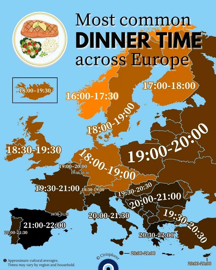
    Most Common Dinner Time Across Europe
    Map displaying common dinner times across European countries, featured in fascinating maps that explain the world.

    vladgrinch Report

    #60

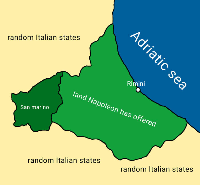
    Mapped The Exact Coastal Land Napoleon Offered To San Marino In 1797 (Which They Famously Declined To Avoid Making Enemies)

    Historical map showing San Marino and land offered by Napoleon, part of fascinating maps that explain the world.

    anasazher Report

    ADVERTISEMENT
    #61

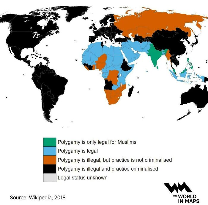
    Legality Of Polygamy

    World map showing the legal status of polygamy by country, color-coded to explain global laws.

    vladgrinch Report

    ADVERTISEMENT
    #62

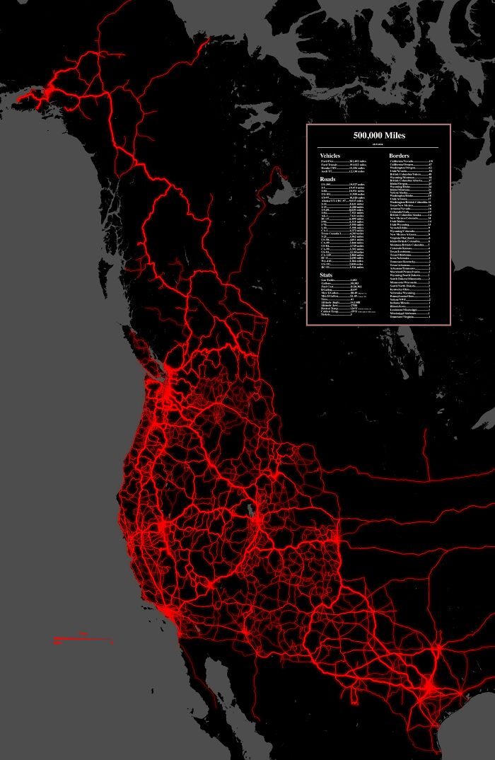
    I Spent The Last 7 Years Exploring The West

    A glowing red travel map of North America showing 500,000 miles driven across various roads and borders.

    EverestMaher Report

    #63

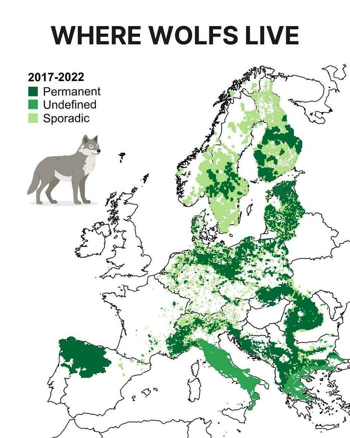
    Where Wolves Live In Europe

    A map of Europe illustrating wolf distribution regions from 2017 to 2022.

    hernancb21 Report

    #64

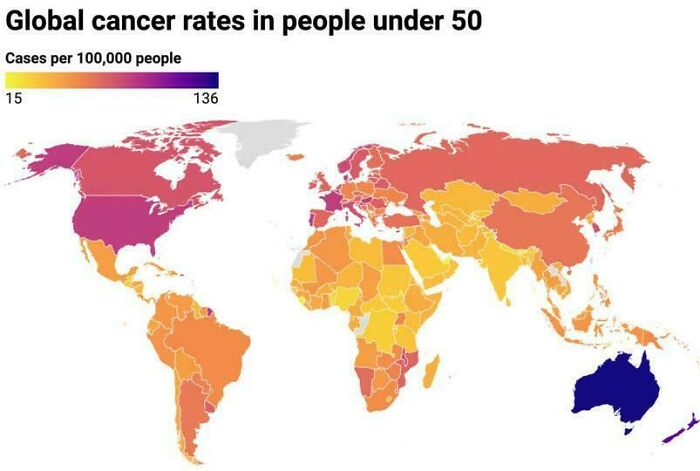
    Global Cancer Rates In People Under 50

    A global map showing cancer rates in people under 50 years old.

    vladgrinch Report

    ADVERTISEMENT
    #65

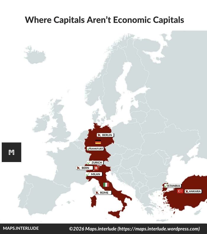
    Where Capitals Aren’t Economic Capitals

    A map showing European countries where political capitals differ from economic capitals.

    quindiassomigli Report

    ADVERTISEMENT
    #66

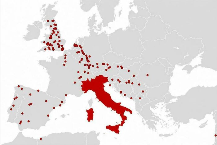
    Cities The Romans Founded Outside Italy

    A map of Europe displaying locations with red markers centered around Italy

    vladgrinch Report

    #67

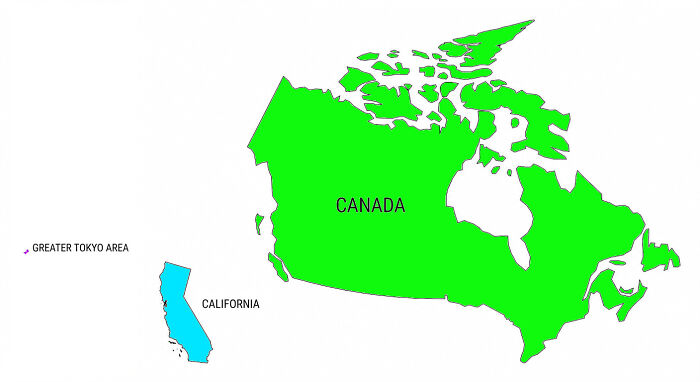
    These Three Places All Have About The Same Population Size
    A size comparison map showing Canada, California, and the Greater Tokyo Area

    KelVelBurgerGoon Report

    #68

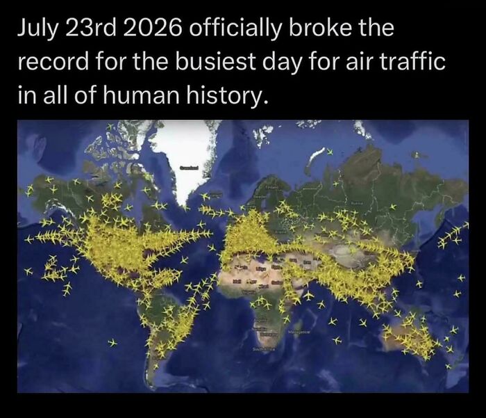
    7/23 Busiest Air Travel Day In History

    A global flight tracking map illustrating heavy air traffic around the world

    ayachdee Report

    ADVERTISEMENT
    #69

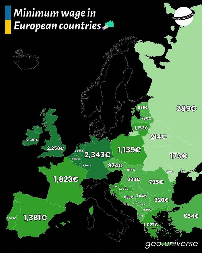
    Minimum Gross Wage Across Europe

    A map showing minimum wage figures across European countries

    vladgrinch Report

    ADVERTISEMENT
    #70

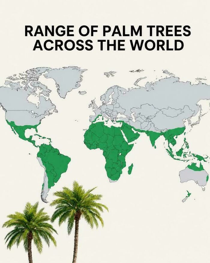
    Range Of Palm Trees Across The World

    A world map highlighting the geographic distribution range of palm trees across tropical and subtropical regions.

    AdIcy4323 Report

    #71

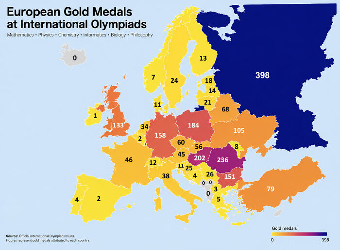
    European Gold Medals At International Olympiads

    A map of Europe displaying gold medals won by each country at international scientific olympiads.

    DanDanCC Report

    #72

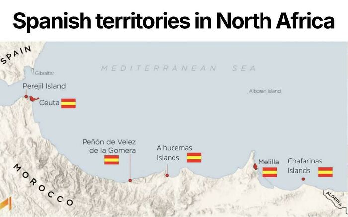
    Spanish Territories In North Africa

    A map illustrating Spanish territories along the coastline of North Africa, featuring flags next to key locations.

    vladgrinch Report

    ADVERTISEMENT
    #73

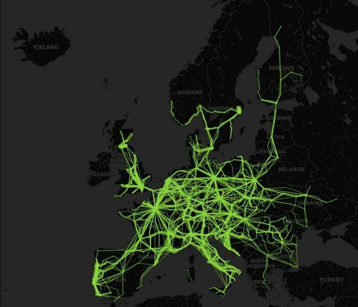
    Flixbus Services In Europe (As Of 2026)

    A dark map of Europe showing interconnected high-speed rail lines highlighted in bright green, part of fascinating maps.

    Mackelowsky Report

    ADVERTISEMENT
    #74

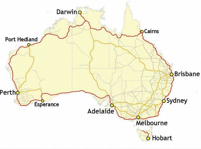
    Australia's Highway 1 Is The World's Longest National Highway

    A map of Australia highlighting major coastal highway routes connecting cities as part of fascinating maps that explain.

    vladgrinch Report

    #75

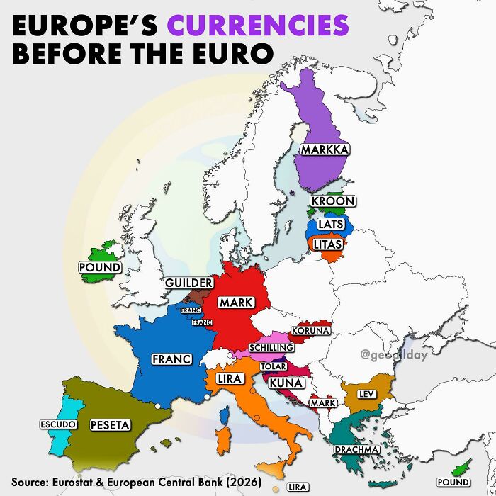
    Europe's Currencies Before The Euro

    Color-coded map showing former national currencies across Europe before the adoption of the euro.

    BeginningMortgage250 Report

    #76

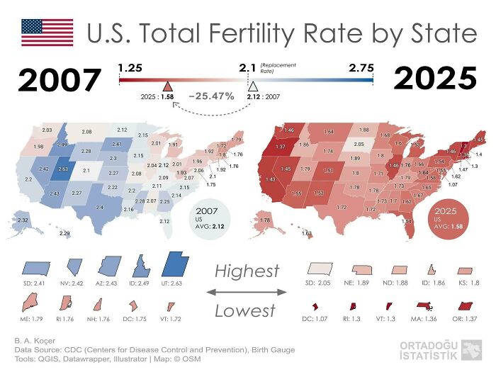
    Fertility Rate Of The US By State In 2007 vs. 2025

    Comparison map showing changes in US total fertility rate by state from 2007 to 2025.

    Delicious-Bunch-6992 Report

    ADVERTISEMENT
    #77

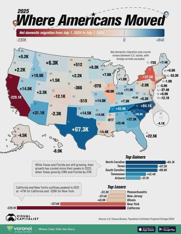
    States Where People Are Moving From And Where They're Moving To

    Infographic map showing net domestic migration across US states in 2025, one of many fascinating maps.

    Dec8rs8r Report

    ADVERTISEMENT
    #78

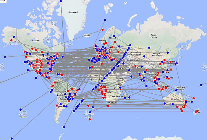
    Every Portal In Google Street View

    Fascinating map showing global flight paths and connections between major international locations with dots.

    gantickwastaken Report

    #79

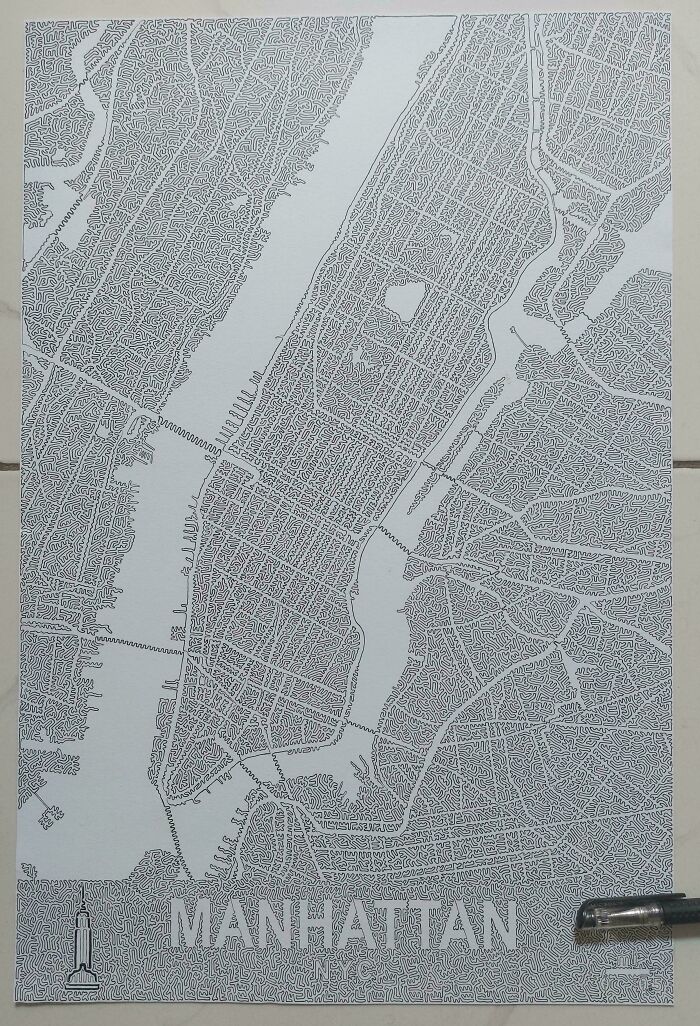
    I've Drawn Manhattan With One Line That Never Intersects [oc]

    Intricate single-line drawing of a Manhattan map, showcasing artistic fascinating maps that explain cities.

    The-bubator Report

    #80

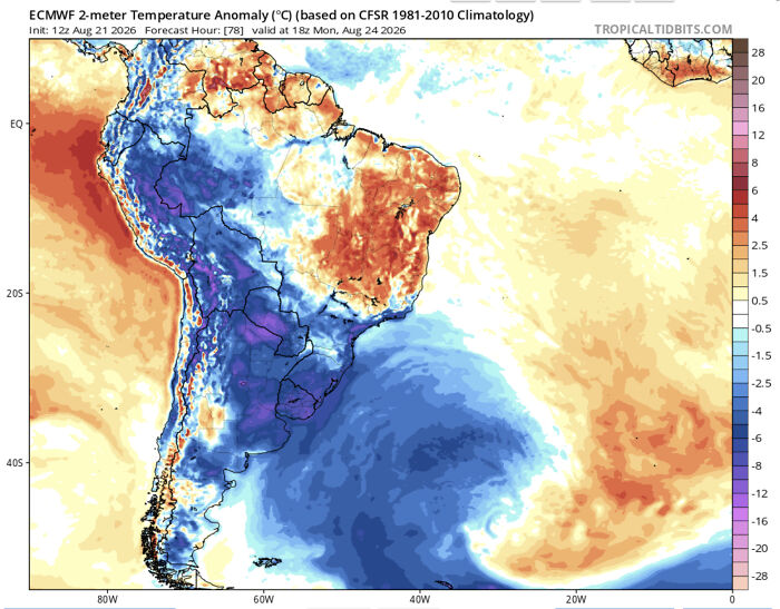
    Antarctica Ejects Anomalously Cold Temperatures Towards South America

    Fascinating map displaying a temperature anomaly forecast across South America with heat and cold zones.

    Swimming_Concern7662 Report

    ADVERTISEMENT
    #81

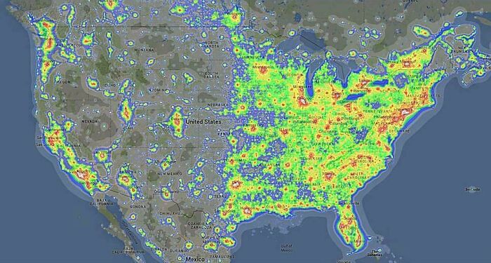
    Light Pollution Across The United States

    Fascinating map showing light pollution levels across North America, illustrating human activity clearly.

    vladgrinch Report

    ADVERTISEMENT
    #82

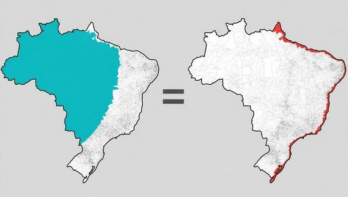
    The Same Number Of Brazilians Live In Each Highlighted Area
    Fascinating maps illustration showing population density comparison between inland Brazil and its narrow coastline.

    vladgrinch Report

    #83

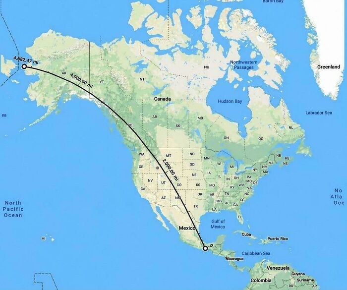
    The Longest Straight Line You Can Walk In The Americas

    Fascinating maps display showing a straight geographic distance line drawn across North America from Alaska to Mexico.

    vladgrinch Report

    #84

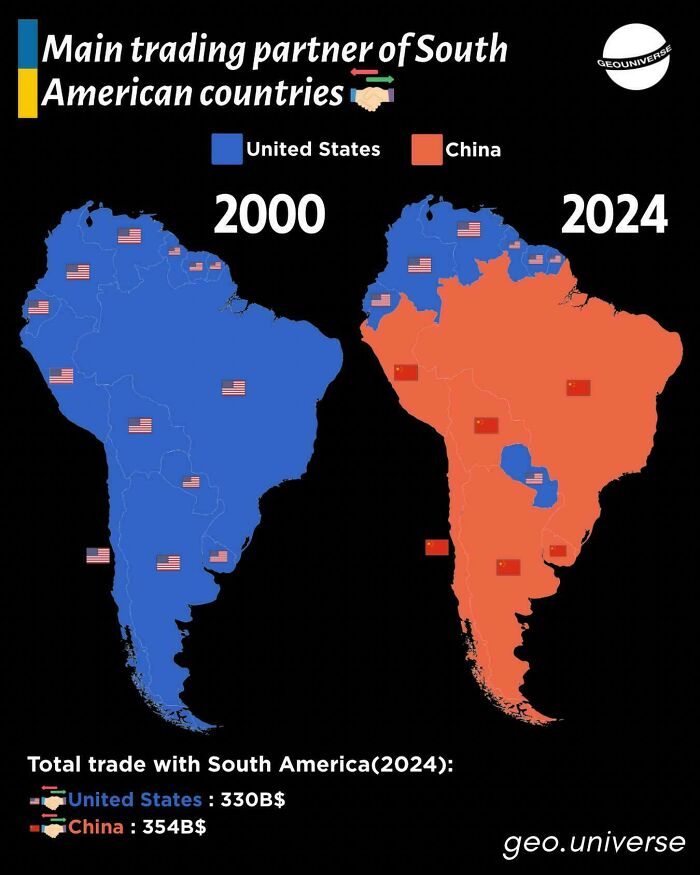
    Trading Partners Of South America

    Comparison map of main trading partners in South America showing US vs China trade shifts, illustrating fascinating maps.

    Junior_Insurance7773 Report

    ADVERTISEMENT
    #85

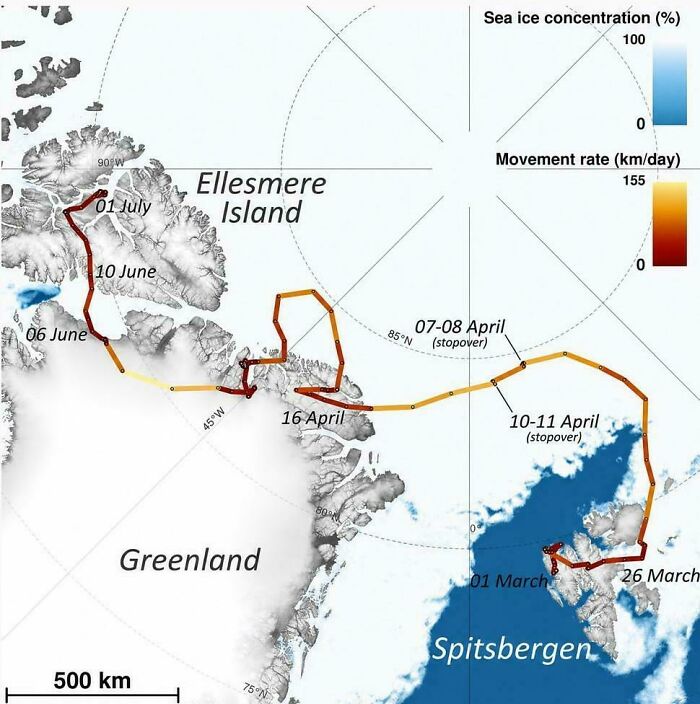
    An Arctic Fox Walked From Norway To Canada In 76 Days

    A map tracking animal movement across Spitsbergen, Greenland, and Ellesmere Island over several months.

    vladgrinch Report

    ADVERTISEMENT
    #86

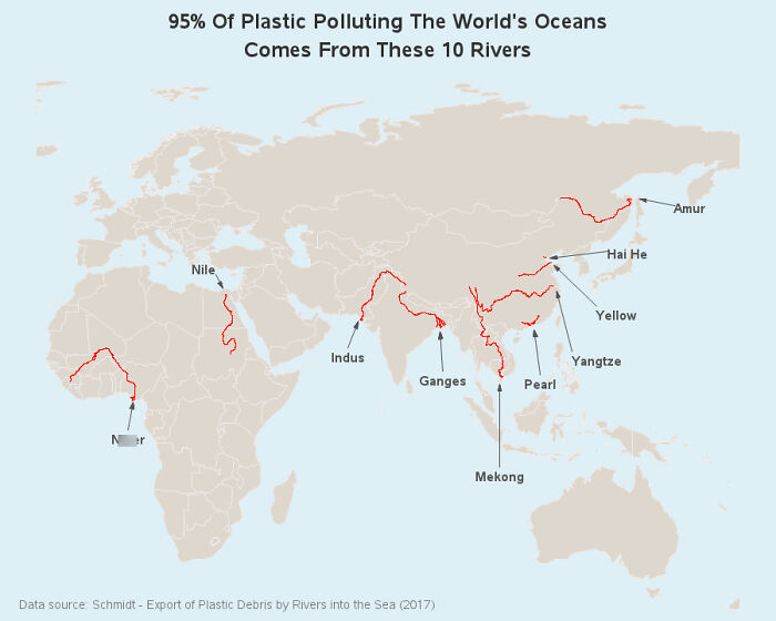
    95% Of Ocean Plastic Comes From Only 10 Rivers

    A map showing 10 rivers responsible for 95 percent of ocean plastic pollution, highlighting key global rivers in red.

    HelloWinterHello Report

    #87

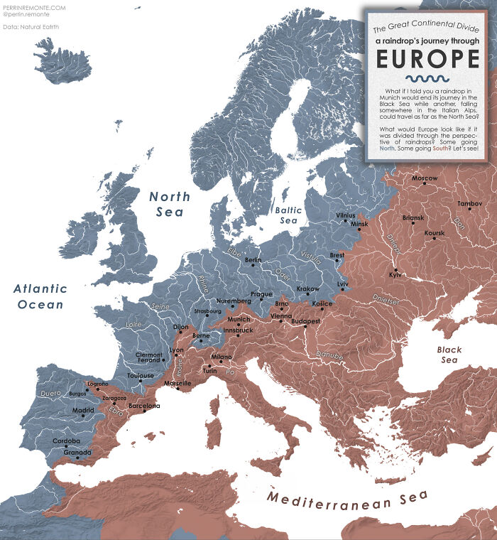
    The Great Continental Divide - Or A Raindrop's Journey Through Europe [oc]

    A hydrological map showing Europe divided by river basins, part of a set of fascinating maps.

    mydriase Report

    #88

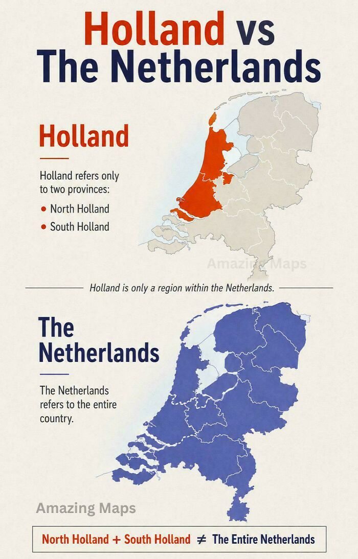
    Holland vs. The Netherlands

    Educational map explaining the geographical difference between Holland and The Netherlands.

    vladgrinch Report

    ADVERTISEMENT
    #89

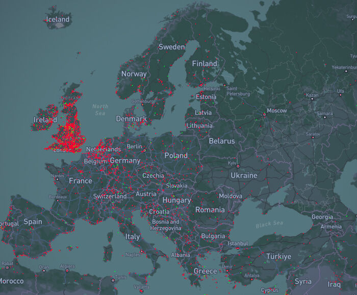
    Europe's UFO Reports Map

    A map of Europe displaying data points in red and green, illustrating fascinating geographical statistics.

    BlokZNCR Report

    ADVERTISEMENT
    #90

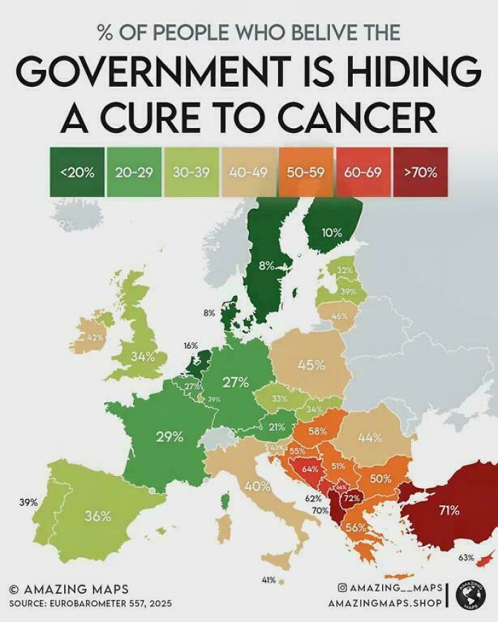
    People Who Believe The Government Is Hiding A Cure To Cancer

    A European infographic map displaying percentages of belief in government cancer cure conspiracies.

    milehiboy Report

    #91

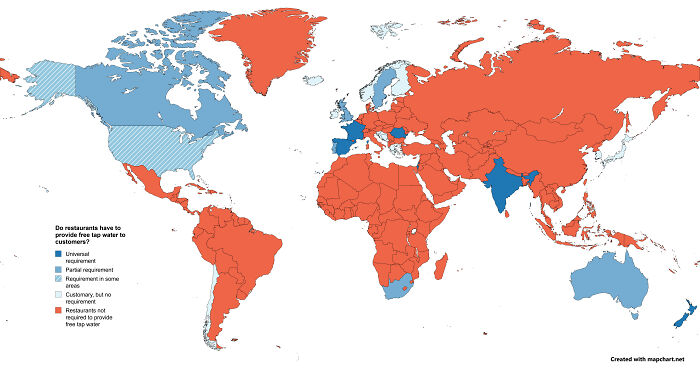
    Legal Obligation To Provide Free Tap Water In Restaurants

    A world map illustrating global restaurant policies on providing free tap water to customers.

    MonotoneCreeper Report

    #92

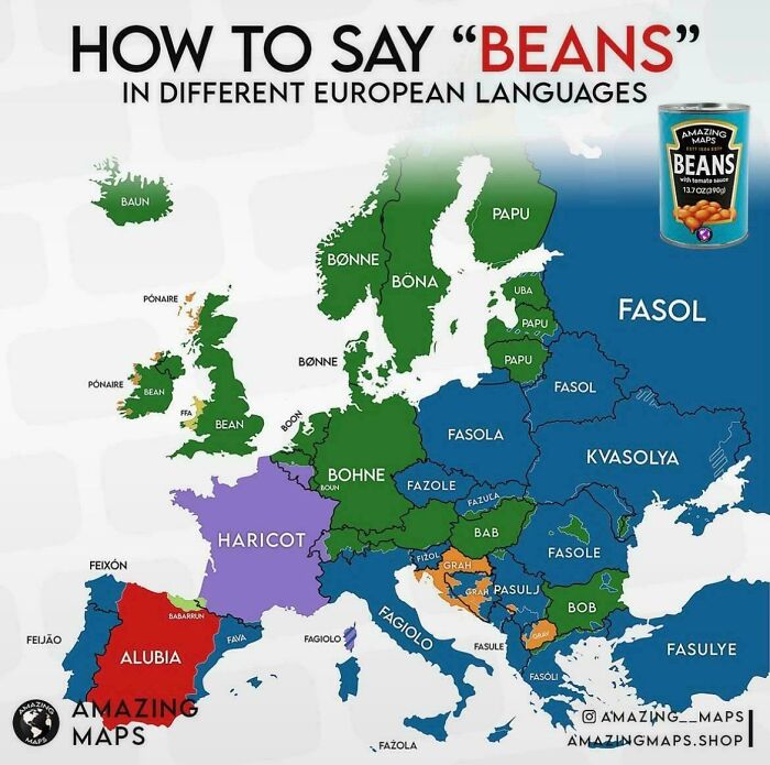
    How Do You Say "Beans" In Different European Languages

    Linguistic map of Europe showing words for beans in various languages, among fascinating maps that explain the world.

    vladgrinch Report

    ADVERTISEMENT
    #93

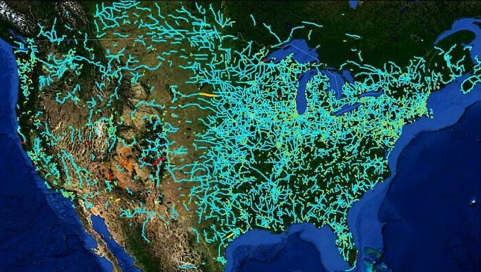
    America's Abandoned And Out-Of-Service Railroad Lines

    Satellite map highlighting US natural gas pipelines, featured in fascinating maps that explain the world.

    vladgrinch Report

    ADVERTISEMENT
    #94

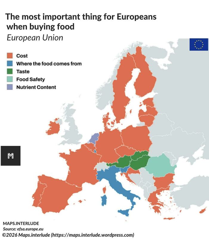
    The Most Important Thing For Europeans When Buying Food

    Color-coded map showing what Europeans prioritize when buying food, part of fascinating maps that explain the world.

    quindiassomigli Report

    #95

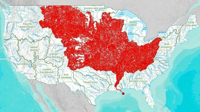
    The 7000 Rivers That Feed Into The Mississippi

    Detailed map of the US highlighting river basins in red, an example of fascinating maps that explain the world.

    vladgrinch Report

    #96

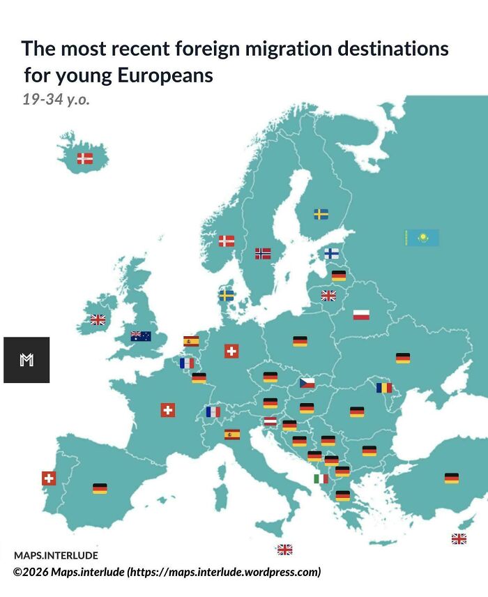
    The Most Recent Foreign Migration Destinations For Young Europeans

    European country map displaying top foreign migration destinations for young Europeans as part of fascinating maps.

    quindiassomigli Report

    ADVERTISEMENT
    #97

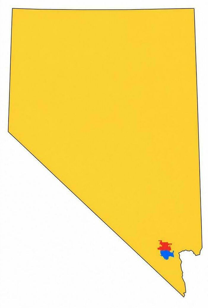
    Nevada Split Into 3 Areas Of Equal Population

    A map of Nevada showing population density concentrations highlighted near Las Vegas.

    vladgrinch Report

    ADVERTISEMENT
    #98

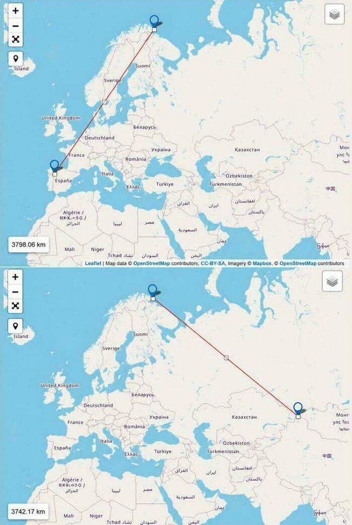
    From Vardø, Norway, It's Closer To China Than Portugal

    Side-by-side maps showing flight route distances across Europe and Asia with red trajectory lines.

    vladgrinch Report

    #99

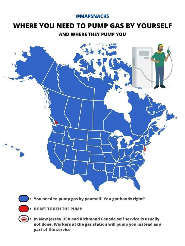
    Where You Need To Pump Gas By Yourself

    A map showing self-service vs full-service gas stations across North America.

    vladgrinch Report