ADVERTISEMENT

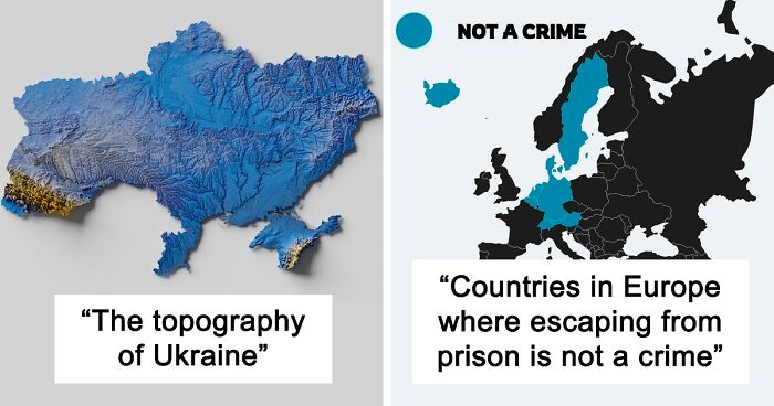
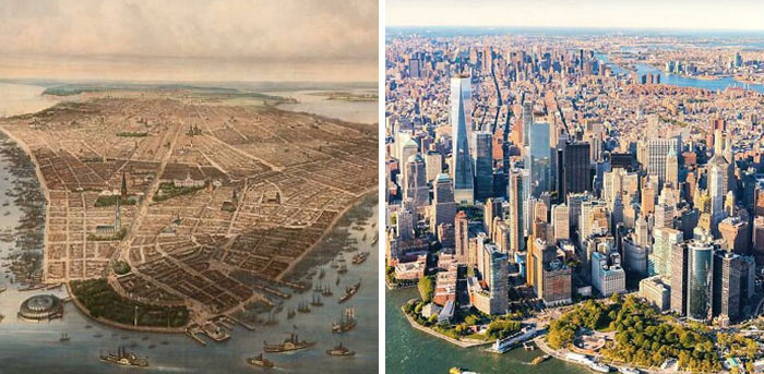
Where would you start if you were looking for a treasure? Well, from what we learned in Jumanji, we probably need a map. In fact, maps, the precious representation of information, are key to so many secrets of the world, whether it’s the Earth, our history, politics, sociology, or anything, really.

Thanks to this corner of Reddit known for being the ultimate destination for fans of cartography, we can devour an endless variety of maps that all differ in information, style, size and other features. With 1.8 million members of the community, it’s now turning into one of those Reddit powerhouses that gives the best of online content.

Scroll down through the new batch of maps below and after you’re done, be sure to share our previous posts with the most unique and informative diagrammatic representations you may not have even known existed, here, here and here.

Click here & follow us for more lists, facts, and stories.

#1

The Baltic Way. On 23 August 1989, Two Million People Joined Their Hands To Form A Human Chain Spanning 675.5 Km Across The Three Baltic States. The Protest Was Against The Soviet Occupation, And To Support The Independence Movements Of The Three States

The Baltic Way. On 23 August 1989, Two Million People Joined Their Hands To Form A Human Chain Spanning 675.5 Km Across The Three Baltic States. The Protest Was Against The Soviet Occupation, And To Support The Independence Movements Of The Three States

RepublicOfEurope Report

RELATED:
    #2

    "Head North, Young Man..."

    "Head North, Young Man..."

    5_Frog_Margin Report

    #3

    Cyclist Recreates Nirvana’s “Nevermind” Album Cover

    Cyclist Recreates Nirvana’s “Nevermind” Album Cover

    TRiskProduction Report

    Bored Panda reached out to the subreddit’s founder Patrick to find out how Reddit's cartography powerhouse has been doing since we last spoke a while ago. He describes himself as “a Denver-based techno-geek with a focus on all things geospatial and cartographic and a coding hobbyist with an emphasis in geospatial applications.”

    ADVERTISEMENT

    “The subreddit has been stable the last few months, however, that all changed this morning with the news out of Ukraine of the military action there,” he said. “The subreddit usually has between 2,000 and 4,000 users at a given moment on a normal day. That number spiked to a peak of over 20,000 users looking for current maps of the situation there.”

    #4

    Topography Of China

    Topography Of China

    MeronDC Report

    #5

    All Roads Lead To Rome. This Map Is Visualises The Famous Roads Built By The Roman Empire

    All Roads Lead To Rome. This Map Is Visualises The Famous Roads Built By The Roman Empire

    symmy546 Report

    ADVERTISEMENT
    #6

    Atheists Are Prohibited From Holding Public Office In 8 US States

    Atheists Are Prohibited From Holding Public Office In 8 US States

    clayagds99 Report

    ADVERTISEMENT

    Patrick believes that the way people think of cartography is changing. “The previous generation was accustomed to paper maps that they used to navigate. This required skills in orientation and awareness that are no longer necessary with digital maps on mobile devices. Whilst there are lots of articles that eulogize the loss of these skills, I don't think it's necessarily all bad.”

    #7

    The Topography Of Ukraine

    The Topography Of Ukraine

    boytutoy Report

    #8

    Map Showing Netherland's Progress In Flood Management (Source: Earthmagazine)

    Map Showing Netherland's Progress In Flood Management (Source: Earthmagazine)

    WildestEconomist Report

    #9

    Is Escape A Crime?

    Is Escape A Crime?

    Mmaps_interlude Report

    ADVERTISEMENT
    ADVERTISEMENT

    According to Patrick, the history of cartography is full of changes in how maps are created and used. And right now, “we're seeing another shift in response to the digital age.” The sub’s founder explained that “the digital generation has a heightened awareness of how maps can visualize data. The tools to make maps have been democratized. This has increased interest in finding new and clever ways to see spatial data.”

    “I think the hottest trends are in maps that elucidate some sort of political understanding. These can be maps of elections, voting districts, gerrymandering, political recognition, voting patterns, etc. Social media is engineered to spur controversy and this is most apparent in hot button political topics. Politically themed content will garner more discussion, controversy and comments than most other topics.”

    #10

    All The Countries That Have Gained Independence From Great Britain

    All The Countries That Have Gained Independence From Great Britain

    User Report

    #11

    Beavers In Europe, 1900 And 2021

    Beavers In Europe, 1900 And 2021

    Mackelowsky Report

    ADVERTISEMENT
    #12

    Most Popular Language On Duolingo

    Most Popular Language On Duolingo

    Coldcomplex1 Report

    Patrick is a member of #maptime Denver, Rocky Mountain Map Society, NACIS, PLSC, Charles Close Society and Open Street Map Foundation. So he always has a new project up his sleeve. Right now he’s working on building a plugin for QGIS, an open-source map-making software.

    ADVERTISEMENT

    “The topic is map projection distortion. We all know that flat maps distort the shape of the Earth. However, visualizing this is quite difficult. My plugin will work so that a user can input a projection and a given region. The output will be a map overlay that shows where the scale is closest to true and where it falls below a given threshold,” he told us and added that he’ll be happy to share it when it's finished.

    #13

    Countries With A Higher Life Expectancy Than The United States

    Countries With A Higher Life Expectancy Than The United States

    burgerking_foot Report

    ADVERTISEMENT
    #14

    The New Longest Possible Train Journey In The World

    The New Longest Possible Train Journey In The World

    htGoSEVe Report

    #15

    The Red Part Contains More People Than The Blue Put Together

    The Red Part Contains More People Than The Blue Put Together

    AndoMacster Report

    Never miss a story that brings joy to the world. Follow on Google News

    #16

    Russian Military Build-Up Around Ukraine

    Russian Military Build-Up Around Ukraine

    User Report

    ADVERTISEMENT
    #17

    A Map Visualizing The Armenian Genocide - Started 106 Years Ago

    A Map Visualizing The Armenian Genocide - Started 106 Years Ago

    roiaumedejherusalem Report

    ADVERTISEMENT
    #18

    World Map, But It’s Centered On Buenos Aires, Argentina

    World Map, But It’s Centered On Buenos Aires, Argentina

    burgerking_foot Report

    #19

    London's Piccadilly Tube Station. Piccadilly Circus Is A Road Junction And Public Space Of London's West End In The City Of Westminster. It Was Built In 1819 To Connect Regent Street With Piccadilly

    London's Piccadilly Tube Station. Piccadilly Circus Is A Road Junction And Public Space Of London's West End In The City Of Westminster. It Was Built In 1819 To Connect Regent Street With Piccadilly

    5igorsk Report

    #20

    Countries That Have, Or Have Had, Openly Gay Heads Of Government

    Countries That Have, Or Have Had, Openly Gay Heads Of Government

    Porodicnostablo Report

    ADVERTISEMENT
    #21

    This Is A Really Fascinating Map. Languages Of Europe Around 600 Ad

    This Is A Really Fascinating Map. Languages Of Europe Around 600 Ad

    _Hydrohomie_ Report

    ADVERTISEMENT
    #22

    World Map According To China In 1799

    World Map According To China In 1799

    imrahul08 Report

    #23

    US States In Which Homosexuality Was Illegal From 1962 To 2012

    US States In Which Homosexuality Was Illegal From 1962 To 2012

    Mackelowsky Report

    #24

    Map Of The 2191 Meter Deep Krubera Cave. The Deepest Known Cave System In The World

    Map Of The 2191 Meter Deep Krubera Cave. The Deepest Known Cave System In The World

    bacs05rc Report

    ADVERTISEMENT
    #25

    This Is The Farthest Place On Earth From Any Ocean

    This Is The Farthest Place On Earth From Any Ocean

    MeronDC Report

    ADVERTISEMENT
    #26

    % Of Europeans Who Would Fight For Their Country

    % Of Europeans Who Would Fight For Their Country

    adorn_mapper Report

    #27

    Map For Halloween - Every Castle In Europe

    Map For Halloween - Every Castle In Europe

    Spatial_Overlay Report

    #28

    Most Obese Countries

    Most Obese Countries

    No-Ad7595 Report

    ADVERTISEMENT
    #29

    Age Of Women At Birth Of Their First Child (Europe)

    Age Of Women At Birth Of Their First Child (Europe)

    Quiet-Luck Report

    ADVERTISEMENT
    #30

    School Shootings In Europe Since 2010

    School Shootings In Europe Since 2010

    Nic0487 Report

    #31

    Map Presenting Coldest Temperatures Ever Measured In Celcius...

    Map Presenting Coldest Temperatures Ever Measured In Celcius...

    Jazzlike-Power-7959 Report

    #32

    Piracy In The 21st Century

    Piracy In The 21st Century

    shashsainik Report

    ADVERTISEMENT
    #33

    Grading System In Europe

    Grading System In Europe

    User Report

    ADVERTISEMENT
    #34

    Most Frequent Causes Of Deaths For 50 To 69-Year-Olds. @realworldmaps

    Most Frequent Causes Of Deaths For 50 To 69-Year-Olds. @realworldmaps

    Realworldmaps Report

    #35

    Eu Countries Pushing To Label Nuclear Power As Green Energy

    Eu Countries Pushing To Label Nuclear Power As Green Energy

    PepperBlues Report

    Add New Image This post is a community curated image gallery Add Image
    Add New Image

    Add Your Photo To This List

    Please use high-res photos without watermarks

    Upload Photo

    Not your original work? Add source

    Publish