Get Premium
Dark mode theme is available exclusively for premium users. Learn more about the benefits of subscribing.
No fees, cancel anytime.

 Dark Mode Ad-Free Browsing Unlimited Content
 Ad-Free Browsing Unlimited Content Dark Mode
Join 1.2 million Panda readers who get the best art, memes, and fun stories every week!
It is hard to imagine navigating the streets of the world without help from Google Maps. However, while most of us use the app to find our way around, some people use the Google Earth street view option to 'travel' the world or look for exciting occurrences in the endless collection of images.
A geologist from New Orleans named Will could put searching for beautiful landscapes on Google Earth under his hobbies. The guy spends a lot of time exploring various areas of the map and snapping screenshots of places he found most interesting. Posting under the name geologistsmakethebedrock, this man has shared a couple of galleries with the internet people, adding short descriptions to each of the interesting photos. "I really like to peruse Google Earth looking for cool nature images. My captions either come from basic internet research of my guess about what's happening. Keep in mind that they are just my interpretations of things and could be wrong" he explained.
"I tried to find interesting examples of geologic processes to use in lecture presentations. That’s when I started gathering screenshots of cool stuff for myself. Then I decided to share some images on Imgur because my wife was tired of me making her look at them and listen to my explanations" he told Bored Panda. Will admitted that most of his choices to look into are random, but there are times when he follows a certain trail he's interested in. "One tip for finding interesting geology things is to look for symmetry or patterns in landscapes. Most symmetry is from human activates, but certain geologic processes can create semi-symmetry," he explained.
Most of his screenshots feature various land formations and beautiful nature occurrences that draw the eye, as well as some human-made structures that seem to have a story behind them. Google Earth has been a thing since 2001, though back then it was only in the initial stage of what it eventually became. Within years the project evolved and from flat, often puzzle-like map we finally got realistic 3D depictions of many countries across the globe. The project even expended further than Earth's boundaries as Google launched such branches as Google Mars and Google Moon.
There's a lot out there to explore, so if you lack funds or the ability to go on long flights to see Norwegian fjords, Mexican deserts, and amazing street photography shots power up the app and see where it takes you. Oh, but before that, don't forget to check out what geologistsmakethebedrock shared and vote for your favorite snaps!
This post may include affiliate links.
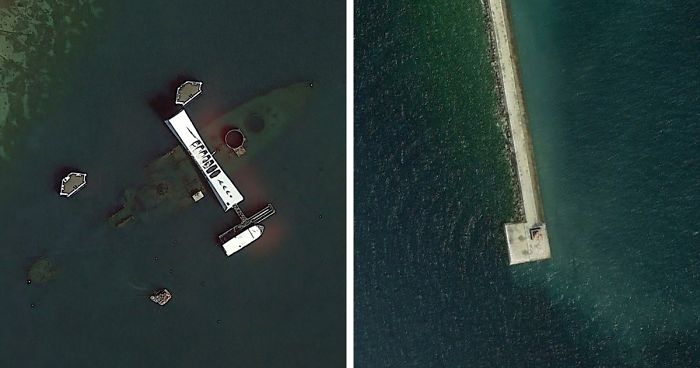
"USS Arizona and memorial, Pearl Harbor."
"A beautifully symmetrical volcano on the Kamchatka Peninsula in Russia. Look at those weird red cinder cones on the flanks."
Does anyone else notice that the landscape is divided into quarters? I thought that more unique than the cinder cones!
"This is my favorite. It's a marina near Milwaukee, Wisconsin (USA). The winter ice is in the process of breaking up. I don't know why, but this is very visually appealing to me."
"A breakwater and lighthouse on one of the Great Lakes. I can't remember where. Notice the circular pattern of waves reflecting off the structure."
"Underwater tidal channels of the Wadden Sea of Denmark."
"Still the Wadden Sea. Look at that tidal current rippin through there. This one is spooky."
"A volcano in the Great Rift Valley in Tanzania. It's tall enough to have its own, wetter micro climate, hence the green."
"Alpine glaciers spilling out spreading across a flat plain. This is in SE Alaska."
"High vs. low tide on a Normandy beach."
"A lonely little gun emplacement that used to guard the entrance to Amsterdam. "
"SE Alaska, multiple alpine glaciers flowing together."
"These are impact craters in the Canadian Shield, the oldest continental crust of the North American plate. Because it’s been tectonically inactive for a long time and continental glaciers removed most of the topsoil, many craters are visible. This lake is called Lac a l’Eau Claire. There is a lot of evidence that the lake is formed by 2 impact craters. It was originally thought that the 2 impacts were formed at the same time by an asteroid that split or was a binary asteroid. There is some very compelling evidence that these are 2 different impacts, ~200 million years apart. It might seem like a million to one shot that 2 impacts could be so close, but we see many overlapping craters on other planets. The low probability thing for me is that the craters were both preserved and exposed."
"Irrigated fields in west Texas. The colors here are awesome. I'm guessing the crops were recently harvested or recently plowed under and we're seeing the soil color. In my experience, harvested corn or wheat fields aren't this orange/red. Any ideas? The white specks are oil pads connected by little roads. This land is certainly being utilized."
A lot of Texas has red soil. Irrigating soil like this is arrant stupidity. The soil modifications, complete with massive amounts of petrochemical base fertilizer will destroy that soil forever. What's even worse is that Texas has a constant water shortage. This kind of agriculture destroys water tables permanently and leaches dangerous chemicals into the water that's left.
"A push boat and barges stirring up the bottom of the Tombigbee River in Alabama (USA)."
"A fort in the Netherlands."
"Above is the coolest delta I've ever seen. It's formed by the William River, which flows through Athabasca Sand Dunes Provincial Park and into Lake Athabasca, Saskatchewan CA. This river has recently become my favorite river, because we share a name. The left side of the image seems to be while the lake is frozen but the river is not. The bands that sort of parallel the shoreline look like cheniers."
"Another volcano in the Great Rift Valley with a micro climate and a very asymmetrical crater, much like Mt. St. Helens."
It almost looks like a crescent moon! The green is such an amazing colour.
"Preserved craters from the D-Day bombardment of German fortifications at Pointe du Hoc, Normandy."
"After the pretty bad performance of the US in the war of 1812, the federal government realized some things. They needed to maintain a larger, federally controlled, standing army. The states militias were just not up to the task when it came to real war. They also needed to have a larger navy. Privateers weren’t all that great either. Finally, they needed to fortify the border. The royal navy was able to sail all up in our waterways to deploy land forces. Since half of the US border was coastal, this meant lots of coastal forts to shoot at ships. Across the channel is Fort Morgan, a beautiful star fort. I’ve never been to this one, but it looks to be in very good shape. You can see the retrofitting of more modern gun emplacements."
"I read about this one on a forum. I think it's true. The GPS point is the location of the German battleship, Tirpitz when it was sunk by British bombers on 11/12/1944. The Tirpitz was the sister ship of the famous Bismarck. It was also the last serious German surface naval threat. The RAF and Royal Navy played a long cat and mouse game with the Tirpitz as it hid out in Norwegian fjords. It was eventually located and Lancaster bombers attached at high altitude with huge bombs. The 3 round holes (2 in the water, 1 on land) are likely craters from missed bombs. They don't make sense geologically"
Scrap metal from the hull of Tirpitz is still used to cover holes in the streets during maintenance work in Oslo.
"An anticline somewhere in Iran with a series of alluvial fans on the south side. I really like the blue color of the formation ringing the center of the anticline. I need to go there and get a sample. You can see the colors of the formations reflected in the fan."
"A huge pile of some black stuff due west of Douglas, Arizona. It looks like a spoil pile from a mine, but I don't see evidence of a mine nearby. Any ideas?"
There are a LOT of mines in the area. I cannot say that it isn't soil, but I am more inclined to think this may be one of the volcanic mines. Perhaps for ballast materials
"A very isolated island off the coast of Germany. What's that? My first thought was it had to be ruins from a very old fortification or something. Turns out no. This little island was man made back in 1989. The features were put there to prevent wind erosion."
North of this island Nigehörn, there is an uninhabited "bird island" named Scharhörn. Since the River Elbe is moving towards Scharhörn and will destroy the island someday, Nigehörn was built as a replacement. Another reason was a new harbour area (planned but never built). Today it is part of Zone 1 of the Hamburg Wadden Sea National Park. Birds breed here, no humans allowed :)
"A beautiful wave-dominated delta in Brazil."
"A cool delta building out into Ayyakum Lake, Tibet. The river is unnamed on Google. It is fed by snowmelt from mountains to the south. You can see some isolated sand dunes NW of the river. There is a name for this type of dune, but I can't remember what it is. They happen when there is enough wind to migrate dunes, but not enough sand."
"I cheated a little with this one. I’ve actually been to this place. It’s an island in Penobscot Bay, Maine, USA. We see 2 very distinctive rock bodies contacting one another. My guess is that the darker rock intruded into the lighter rock due to nearby volcanic activity. Nearby Vinalhaven Island is a very old volcano, and the direction kind of fits."
Looks like that one building is about to slip into the sea. Bad planning that.
"This is a random place in the Ontario, CA. I think the colors are very nice."
"The Rio Grande River entering the Gulf of Mexico."
this is a picture of Boca Chica beach on the bottom and Padre Island on the top. It is a ship channel, about 8 miles north of the mouth of the river. I have lived here for decades.
"A strange shaped clearing in the Punjab province of India. I wonder what that is."
"A sugarcane field burning in south Louisiana, USA. This is commonly done to remove all of the leftovers from harvesting. Sugarcane is a grass so there is a lot of organic material leftover."
In Brazil we don't do this anymore (it's forbidden by law), the machinery (they're insanely expensive) does the service. After that planting soybeans, harvesting, and so sugarcane again. It's a thing we call "direct planting", using the leftovers as protection to the soil.
The exploration of Google Earth provides fascinating insights into the world's landscapes, a concept popularized by a dedicated geologist. His work taps into the allure of discovering remarkable earth formations and human-made structures through satellite imagery.
If you are interested in learning about unique finds on Google Earth, you might explore this project dedicated to uncovering Earth's hidden gems.


 No fees, cancel anytime


