Get Premium
Dark mode theme is available exclusively for premium users. Learn more about the benefits of subscribing.
No fees, cancel anytime.

 Dark Mode Ad-Free Browsing Unlimited Content
 Ad-Free Browsing Unlimited Content Dark Mode
Join 1.2 million Panda readers who get the best art, memes, and fun stories every week!
Geology rocks. Pun very much intended. Now that we've got that out of the way, let' move on to the hardcore things that make up the bedrock of what Bored Panda is all about - beautiful photos that are hot as lava. Please excuse my dad jokes.
A geologist named Will is known for collecting and uploading interesting things he finds on Google Earth. Some of them are very peculiar. Others are breathtakingly gorgeous. But one thing is for certain - all of them are worth seeing. Scroll through our list of Will's amazing discoveries on our beautiful Earth, upvote your favorites, and rock on. Let us know what you think of the geologist's earth views, and after you're done, look through Bored Panda's other list of amazing Google Earth finds.
This post may include affiliate links.
"A fort in Lille, France. I love finding forts while exploring. Star forts are an easy to spot shape. I esp. like finding forts in the middle of cities."
The Fortress is still used by the army, the Headquarter of the quick response force....Take at look at the city of Palmanova in Italy
"This is a private island on the coast of Maine. The bridge has a gate, and the house overlooks a shipping lane in Penobscot Bay. I'd spend all day watching boats, drinking wine, and telling the world to fuck off."
He instead spends all day in front of a computer screen searching for interesting things On Google Earth....
"It looks like an abstract painting. My first thought was a huge archeological excavation site. Turns out that was wrong. These pits are used in a very old fashioned salt extraction operation."
Will goes by the user name geologistsmakethebedrock on Imgur, where he uploads most of his Earth map finds. The geologist from New Orleans told Bored Panda in an earlier interview a little bit about what he does: “I tried to find interesting examples of geologic processes to use in lecture presentations. That’s when I started gathering screenshots of cool stuff and beautiful landscapes for myself. Then I decided to share some images on Imgur because my wife was tired of me making her look at them and listen to my explanations."
"A very sinuous river. This is a good illustration of how oxbow lakes form. In the middle of the image you can see where a meander loop is being actively cut off."
"A real live oasis!. Not all of these tracks are from cars. The smaller ones must be animal."
"Here is a perfect meteor crater. It has a very nice raised rim. I bet if you mapped out the lake bed you would see a central peak too."
"One tip to find interesting geology things is to look for symmetry or patterns in landscapes. Most symmetry is from human activities, but certain geologic processes can create semi-symmetry," the geologist said.
The geologist also wrote on Imgur that he really likes to “peruse Google Earth looking for cool things. My captions either come from basic internet research or my guess about what's happening.”
"I couldn't find anything about this strange place. It's a huge, planned settlement near Namibe, Angola. It seems to have been constructed around 2013-2014. It also appears to be uninhabited due to no vehicles. Does anyone know anything about this place."
"The circular reflections of these waves is cool."
"This is Assamakka, Niger, a community that appears to be fighting a losing battle with the sands.It's easy to see the prevailing wind direction here."
At first, I thought it looked like gemstones, sapphires half showing in the sand. This is tragic.
Most of us use Google Maps and Google Earth to find our way to where we need to go. Because nobody likes getting lost when they’re in a rush. But there will always be people like Will who see an opportunity to use something functional to find things of beauty.
Google Earth first appeared many years ago, way back in 2001; it’s not a kid anymore, because it turned 18 this summer. Yup, Google Earth can now legally vote and get married.
"I recently read the book, "Skeletons on the Zahara." It tells the true story of some US sailors who wrecked on the NW African coast in 1815. It sucked for them. I wanted to see if I could find a ship wreck. I figured a desert coast would preserve metal wrecks well. It didn't take to long to find this one in NW South Africa. It looks like a modern ship, and sure enough it wasn't there in 2003 (the oldest picture available)."
There are quite a few wrecks along that coast and further. I'm a South African so we get news of wrecks. It could very well be something that happened over the last 10-15 years. If you track further north you enter Namibian territory, known as the Skeleton Coast. The number of wreck going back to the 19th century and earlier, can be found along that coastline. It is not an area that is completely accessible to the public. A certain stretch is out of bounds because it is where diamond mining happens. I worked as an architectural consultant in the town of Oranjemund(mouth of the Orange River), which was a closed town up to quite recently. The Orange River is the boundary between South Africa and Namibia, and if you were to travel as the crow flies, from Oranjemund, Namibe would be about 800-850 km north.
What started as a simple project quickly grew in scope to provide ultra-detailed images of our planet. But that’s not all! Did you know that Google’s project to create 3D representations of Earth eventually grew into something spanning the cosmos? That’s right, there are such things as Google Moon and Google Mars. I mean, how amazing is that? We’re hoping that Will decides to look for awesome finds on the Moon and on Mars, too.
"This is some sort of reservoir in Belgium. I've never seen an octagonal pond before. I wonder why they made it that way."
It's a concrete structure, was probably the easiest, cheapest and safest way to make it back in the 70s. It's also not a pond, obviously, but a place to store water. It's a drinking water production facility.
"A park in Pyongyang, North Korea. Someone at Google in going to be in hot water with the glorious leader."
"A lake somewhere on the Tibetan Plateau in summer and winter."
This guy (as a geologist) should spend more time explaining why these areas look the way they do (or at least tell us where they're located).
"Hey, wanna go out?"
"Cant', my...."
We, the Dutch, also have a famous fictive name for a town called: Schubbekutteveen. Used for & in many national jokes.
"Some huge gates protecting Rotterdam from the North Sea waters. What an amazing feat of engineering."
This is the Maeslantkering, a fine piece of Dutch engineering and very necessary as almost half of The Netherlands lies below the water level. The 2 doors are hollow and are flooded with water once in place. The doors actually don't completely close, there is about 80cm left.
"Atolls:
Hot spots not only punch holes in the crust, but the also raise it up and heat it. As the plate moves away, it cools and subsides. The mountains also subside, and also erode. If the mountains are formed in a tropical climate a reef will form around it's edges. If the coral growth can keep up with the relative sea level rise from the subsidence, then the reef will survive while the mountain sinks and eventually disappears below water level. If that happens you will get a circular ring of reef with an open lagoon in the center like the atoll above. At one point there was a volcano in the center of that lagoon. It's a cool example of biology and geology interacting and biology winning, so to speak."
"A volcano poking up out of the South Pacific. I'm not sure if this one is growing or eroding away. Seems like the rich people in boats are having a good time."
This is Molokini Crater of the coast of Maui. I've been here a few times & trust me when I say those are NOT rich people boats. Most of these are snorkeling charter boats because it has beautiful reefs and marine life. During WWII the U.S. military used it for target practice and it shows in the impact craters from shells and bombs dropped on it.
"When she wants to go to pound town, but you can only take her to..."
"The Zambezi River downstream of the falls. That's a very unusual path for any river."
"I've never seen this saw-tooth pattern on a beach before."
It is a photo of the zipper keeping the sea and the beach together. Tip of the day: do not unzip it!
"While looking up that lava flow in New Mexico, there were some maps showing some nuclear bomb test sites nearby. This must have something to do with that. I'm fairly sure this is the sight of the first nuclear detonation."
As a species, we sure are proof to "a little knowledge is a dangerous thing", and now Trump is eagerly abetting another nuclear arms race. WHY is he still occupying that post? He is clearly not fit for office.
"A glacier flowing out into a lake. The presence of a connecting stream suggests the 2 parts of the lake are at different levels. The glacier made an ice damn. That's pretty cool.
A river trying to do the same thing in another lake."
"I think this is a coal fired power plant in Egypt. Lookin a little nasty."
"The dark green lines caught my eye because they didn't make sense. My guess was that they were logging roads, but then why are they more vegetated than the surrounding fields?
Going back in time. They are certainly logging roads. I guess different plants grew on the churned up roads, thus the different colors seen in the last image."
Trees actually inhibit ground cover growth around them, especially pine and other evergreen types. when these logging roads were cut into the area, they became overgrown with denser ground cover than the areas they (I assume) replanted. they left the roads for when they return in a few years and reharvest.
"This was a pit of an optical illusion. At first it looked like a pyramid, but the coastline is a bluff, so it must be the inverse of a pyramid. My guess is an abandoned evil villain's mansion."
(a) how about a quarry, or (b) you haven't noticed the last image from Dusk till Dawn where the evil temple is revealed?
"More ships near Tombua, Angola. These might have been intentionally abandoned. They were also not here in the 2003 pics."
"A tug boat working barges on the Mississippi River in my home state to Louisiana (USA). Each rectangular barge is ~195 by 35 feet (59.4 m × 10.7 m)."
"Boats going through locks on the Erie Canal"
Then you haven't looked at Ronquires, Belgium. Where they decided not to have a series of locks in the canal, but basically made two gigantic rolling swimming pools connected with a cable: One is up, one is down; boats enter/leave; the 'pool' locks; and they slowly switch to one is down one is up. Incredible waste of money for a little-travelled route.
"I've always been intrigued by these small boggy pond things. Then often have a "spearpoint" shape and share a common orientation. I don't know why they do that.
Oil wells positioned between those funny ponds."
Typical impact sites, as the result of a larger Impactor that struck the planet at a much earlier time. Its not as unusual as it once appeared. This is how all the Carolina Bays were created before the end of the last glaciation. In that one, a huge meteor, or comet fragment, struck the southern N.A. ice sheets and ejected thousands of ice fragments which struck the East Coast, causing craters that left no projectiles lying around. It almost certainly led to the mega-fauna extinction, and that of the Clovis Culture demise. -https://www.scientificpsychic.com/etc/carolina-bays/origin-of-carolina-bays.html -https://www.youtube.com/watch?v=Aw5chtNWzo8
"These are landlocked ships from the drying up of the Aral Sea."
"Image 1: Cool old forts around Antwerp. They look like a maple leaf.
Image 2: More of the forts. There is a large line of them. Presumably they were once around the outskirts of the city, but are now very much incorporated. The flat side with the "stem" is facing the enemy. I've never seen forts built like this
Image 3: These 2 were blurred by GE. I've seen this with military properties in Europe. I wonder why just these 2 were blurred. I wonder what goes on there..."
The ring of forts around Antwerp was built at a safe distance around it: Further than artillery could shoot. When the inevitable next war came, artillery had inevitably advanced and they were useless... Similarly the motorway/ringroad around Antwerp (separating 'antwerp proper' from other towns) is sunken as it was a moat; and the 'inner ring' separating the heart of the city from the rest was a spanish (17th century) wall-and-moat. Now these [numbered!] forts are mostly recreational: One is part of a university campus, another is a park, a third is (amongst others) a natural reserve for bats. They have many cool underground (bombproof) storage cellars, excellent for bats and drunken student revelry. Or I seem to vaguely remember... I doubt there's a military one left (having a small army, it's mostly located in cheaper greener provinces) but you can look up.
"Icebergs and meltwater mixing with seawater.
More of the same. If you stare at the water long enough it seems like you are staring through trees are the night sky."
"The coast of Belgium. You can plainly see the long shore current at work here. It's flowing from the NE to the SW. The rock walls are there to slow the transport, and potential removal, of sand."
These aren’t actual walls, which would make walking along the beach impossible and create dangerous wind blasts towards the town, but ordinary ‘dome-shaped’ breakwaters.
"Some muddy water mixing with some slightly less muddy water. This is in my home state of Louisiana (USA)."
"These are some very cool cinder cones in southern California. I wonder which direction the lava was flowing."
"An active volcanic island in the Pacific Ocean. Look at the beautiful basaltic lava flow on the SE corner. This was the result of an eruption from late 1952 to 1953."
"This might look like an imaging problem, but it's actually patterns of logging in Northern California (USA). I'm not sure why they do it this way. It must have something to do with limiting the area that's clear cut at any one time."
"The Bay of Fundy has the largest tidal ranges in the world. We can clearly see the tidal currents at work here."
"Downtown Dubai in 2008.
Just 11 years later."
In a hundred years it will be below water. Nothing to see here but hubris in action.
"Belgium, these bunkers look like they were part of the German Atlantic Wall."
"Platte River with some clearer water. It's such a pretty braided river."
"An unnamed (on GE) village in Namibia. It looks uninhabited, but it could just not have any cars to leave tracks. The tracks could also just be covered up by blown sediments. It could also be a seasonally inhabited fishing village."
I come from Namibia, but I have no idea where that place on the photo is. Can the author of the post maybe post the geographical coordinates?
"This is in the Punjab region of India. It seems like every inch of land here is planted, except for this part. I can't find any info on this place."
If you were to zoom out on this map, you'd see quite a few of these unplanted zones. This is the result of the Green Revolution, in Punjab. Most of the green is wheat fields, irrigated by ground water. The brown landscape is what the region naturally looks like and where people used to live. Once modern industrial farming methods took hold, subsistence farmers, using traditional, low-yield agriculture were pushed out and left the area for better opportunity. This is actually just another ghost town.
"That's certainly rock, not water. Must be a lava flow. Turns out it's pretty recent too, ~5000 years old."
"This is not the famous "Eye of the Sahara," but another exposed geologic dome.It seems like the road is more of a suggestion in this region. All of those lines are tire tracks."
"A cruise ship watching ice break away from a glacier. I've been on one of these cruises. This was my favorite part of the trip."
Wait is this something people enjoy for fun to watch? Like an activity? Shouldn't we be more worried that they're melting? Or do they just naturally fall apart? (Highly doubtful :/)
"A marina in Monaco. There are few yachts here. The longest one in this picture is only ~250' (75m). Lame."
I guess all our panda's "hubris" comments are reserved, specifically for Dubai... (I'm totally still wondering why... The world is full of displays of opulence, visible from a satellite, such as this one.)
"The Nile River Delta. Don't the cities and towns look a lot like those watering holes in Botswana?"
"This has to be the most braided braided river I've ever seen."
I had no idea of what I was looking at until I saw the word "river"
"This is a glacier in Switzerland. The dark colored parts are caused by sediment being exposed on top of the ice. The regularity of the banding suggests it's caused by something pretty cyclic, like the seasons. I don't know which conditions would make more exposed sediment. It looks kind of like an upside down snake."
"This is a tiny island off the Libyan coast. GE includes some bathymetry data for most ocean basins, but it is not very high definition. Here we clearly see a reef in the photo, that doesn't show up in the light blue part (bathymetry data). If we zoom out, you can just barely see the reef"
"This is a huge peninsula on the coast of Western Sahara. Looks like a large community on the tip. Wrong. It's all boats. That's a lot of boats."
"An alpine glacier. The black lines are sediment sitting on top of the glacier. Glaciers are really good at eroding."
"Point Hope. This has got to be the most isolated place ever."
From Wikipedia: "Point Hope is a city in North Slope Borough, Alaska, United States. At the 2010 census the population was 674, down from 757 in 2000. Like many isolated communities in Alaska, the city has no road or rail connections to the outside world, and must be accessed by sea or by air at Point Hope Airport."
"I wonder what totally legal activities are happening on Homebrew Island... I guess we will never know."
"Awesome sand dunes. The spice must flow."
This is the third one that I would like to permanently be on my wall.
"The trans-Alaska pipeline crossing a river colored by rock flour.
That same river entering another river that's clouded with grayish sediment."
"The island is called Nggela of the Solomon Islands. If you go looking for it, turn off "places" or the quest will be spoiled.
Another ship wreck near a small village of the same island"
"A relatively older wreck on Baia dos Tigres (whatever that means). Sand migration is moving the shoreline away from the wreck."
"This is an incredibly boggy area in Siberia. There is an oilfield in the NE corner. Image trying to travel across this in the summer... I guess an airboat would be the only option."
"I'm fascinated with the man made sand islands in Dubai."
Actually, a Dutch company was (among others) responsible for that. As my nation is kind of famous for its innovative water works/water management & creating new lands straight from the sea.
"Another cool volcano in the Pacific. I don't know if it's trying to grow out of the ocean, or eroding away."
"The Atlantic Mid Ocean Ridge:
The largest mountain ranges in the world (the various mid ocean ridges) were not discovered until after WWII! The navy funded many sonar studies to better understand subsea hazards. This data gave geologists the missing pieces to finally understand how continents moved. The resulting theory of plate tectonics answered innumerable important geologic questions that we take for granted today. All of this stuff happened fairly recently too. I know a few older geologists who were not taught plate tectonics in college.
The image above is cool because we see the offset/stair-step nature of rift zones. Why transform faults? Well, the rifting of oceanic crust is a very brittle operation. It can't just move apart along a straight line. The rift has to accommodate curves from the spherical nature of the Earth and the curved nature of continental crust boundaries. The transform faults are how that curvature is dealt with."
"This might not look like a very impressive delta, but it is. This was the home of Dick Proenneke, a homesteader who was immortalized in the documentary series "Alone in the Wilderness." The river is called Hope Creek. His cabin was just to the north of the mouth."
"Looks like some strong ocean currents right there."
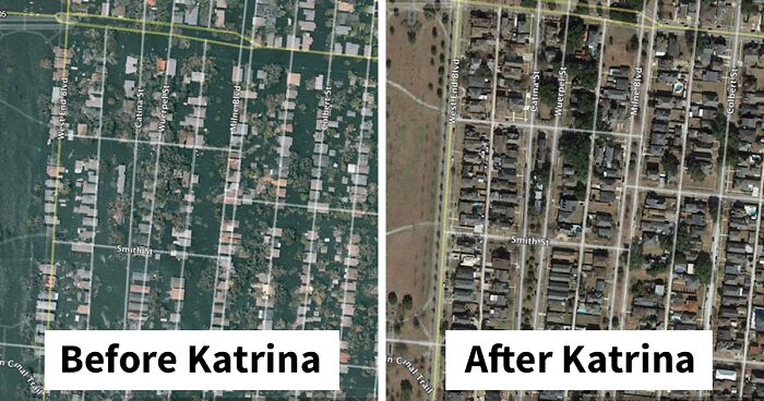
"Present day mid city neighborhood of New Orleans, LA (USA). Looks pretty normal.
Here it is the day after Hurricane Katrina. Things are a bit flooded."
"Some very sinuous tidal channels/lowland drainages on Florida's Gulf coast. This one is kinda spooky if you just focus on the dark water."
Lots of tannin in the water, sometimes you can't see your hand right under the surface.
"This is part of the port of Dunkirk, France. The only way into this area is through the channel at the top of the image. Obviously these ships with the helipads got in there, but it must have been very tight..."
"Looks like an ephemeral watering holes. Look at all of the game pathways crisscrossing the area."
"Ships on the Suez Canal keeping a good and precise distance between each other. Even a slow moving ship needs a lot of room to stop. Here's a big container ship in the Suez Canal."
The hot spot of Hawaii. Simply put, a hot spot is where magma from the mantle punches through the ridged crust making volcanos. Hot spots remain relatively stationary, and the overriding crust moves. So the crust is constantly sliding over a spot that occasionally punches a mountain up through it. That's the case here. The big island of Hawaii is currently over the spot. The other islands were over the spot but have since moved, forming a chain. You can see how the mountain chain makes an abrupt turn. This is indicative of the Pacific Plate changing its direction of travel in the past
"The Gulf of Mexico is my favorite basin. This is not only because I'm from Louisiana, but because it's arguably the most complicated basin in the world. Compare the cont. shelf edge off the Florida coast vs. the Louisiana coast. The Louisiana shelf is very bubbly looking, almost like it's oozing out onto the ocean floor. That is pretty much what's happening. Huge subsurface salt deposits are being squeezed out by the weight of newer sediments deposited on top of it. There are corresponding salt deposits off the Mexican coast as well. The Gulf did not open evenly, but in a rotational fashion with a pivot point somewhere off the Yucatan."
"The Platte River in Nebraska (USA). The mid-channel bars are clearly visible here. There is some old saying about this river that goes something like, "1 mile wide and 1 foot deep." Or something like that."
"Bay of Fundy. Here we are at low tide. I forgot to add a scale, but you can imagine how long that mud flat is."
"This is the flood plain of the Danube River in Hungary. We can see an old oxbow lake W of Makad and lots of evidence of past natural levees (all the swirly lines)."
"A sweet tidal channel."
"A canyon/drainage with a very short river and it's delta. It's a very compact package."
"Barchan dunes in Namibia. These happen when there is more wind than sand in an aeolian system."
"The colors of these formations are very cool and probably only appreciated from an aerial view."
"I've never seen a river meander in such a zig-zag way, as opposed to a loopy way. I have no idea why it does that.
Another river in the same area. weird."
That is humans controlling the meanders, which also reduces the carrying capacity of the river by a lot.
"Oh great! We shipwrecked in a bay full of sandwiches. - Sailor who is about to die of dehydration in the desert."
"This is the Uinta Mountain chain of Utah. It's not often you get to see an entire mountain range in one view. Thanks Google Earth."
"This is a random mountain in the Alaska Range. This is what happens when rock layers are uplifted but not tilted. All of these contacts are horizontal, leading to the stair-step appearance. You can tell they are horizontal because the distance between 2 contacts in map view is the same from one place to another."
"This looked like some sort of mine. I didn't know what kind of ore or mineral could be mined from a cinder cone. Turns out that was very easy to learn. I just googled "cinder cone mine" and this one was the first result. Turns out you mine "lava rocks" from this type of volcano... duh. This is an abandoned mine called the Aiken Cinder Mine. Apparently they just walked away from the operation and left all the equipment. According to the internet, you can drive to it and explore."
You can explore it. You need a high clearance 4 wheel drive vehicle and experience driving in sand to get there.
"This is a river valley in Central Utah (USA). I really like the bluish grey color of the heavily eroded formation."
"These are some nice canyons on the Libyan coast. Since the canyons meander, the river that formed them existed before the area was uplifted, which allowed the rivers to incise and form the canyons."
"I call this one "erosion." The center is a plateau being eaten away on both sides. It also looks like when people burn wood with electricity."
"Note the delta of the Yukon River just south of the 'Norton Sound' label. Now note Whitehorse YT. That is the longest known freshwater salmon migration in the world! Over 3000km! That's unbelievable, esp since the salmon don't eat once they enter freshwater."
"A cool geology one. The W half of the picture shows lines that parallel the coastline then verge landward. This area was build out to see by longshore transport of sand. Then it was covered by the dunes you see in the E half."
"An ephemeral dessert river."
"The Appalachian foothills of West Virginia, Virginia, and Kentucky. I noticed all of the lighter colored areas. Usually things like that are cities. In this case, it's all surface coal mines. I had no idea there were so many of them."
"The chalk cliffs of Dover. You can see large areas cleaving off and slumping into the channel."
"A super cool fort on the S shore of Lake Garda in Italy. This looks like a quite defensible position.."
"Zoomed out shot of the Zambezi River. Do you see the geometric nature of the features here? It looks like cracks interesting at about 60 deg on the acute angle and 120 deg on the obtuse. This is likely some regional jointing (geology for big cracks). You can see areas where the river follows the joints and cuts across others. This suggests the river incised into it's valley very quickly due to uplift of the land. This is the same reason that the Colorado River is meandering despite being in a deep canyon. If the uplift is quick, the river can't adjust it's course in time and is trapped (relatively speaking)."
"This is in the Sahara Dessert. This pattern is very cool. I'm guessing the NE-SW trending lines are the result of prevailing winds shaping the sands and rocks. Notice how things are funneled between the 2 mountainous areas."
"An inland delta in Libya. This is possibly man made. At the least it's influenced by man."
"This is in Western Sahara. It is a great example of a drainage divide. The jagged line running roughly W-E is such a divide. Drainage patterns S of the line drain S, N of the line drains N."
"The Caribbean:
This area is very complex and I don't know very much about it. The image shows how cool it is to have satellite pictures and bathymetry in one image. Adding in the seafloor feature explains why these islands have their shape. Look at the SW edge of Cuba and the NW and SW peninsulas of Haiti. All of these features are explained by how the underlying plates are interacting. You can see a small oceanic spreading center (rift) just south of Grand Cayman."
"The circular feature here currently a slight depression. That depression is the only evidence for the largest domestic explosion in the UK's history. At least I think this is it. I was lead to the area by some info from an old forum."
"The small boats are the tenders used to get to the boats. We can see who's out fishing and who isn't."
"This is in N Botswana, just N of the Okavango Delta. You see this W-E lineation all over the region."
"This is an edge of a dune field with exposed bedrock to the E. The Curoca River is hugging the edge of bedrock."
"This is what happens when a river isn't powerful enough to beat the ocean at its delta. The longshore currents have crossed the river's delta."
"Ephemeral rivers on this plateau. It would be very cool to see the waterfalls after a rain."
"The delta of the Mississippi River in SE Louisiana. New Orleans (my home city) is the developed part in the NE corner. This is a good exercise in determining vegetation from sat. images. The dark green parts are freshwater swamps (wooded). The light green and grey is developed (cleared) land. Now, as in the times of the Native Americans, settlement in this area is along the natural levees of the river and its distributaries. This can be plainly seen in the image. The brownish-green parts, between the dark green and open water, are fresh and brackish marshes. Further out we see the skeletal remains of saltwater marshes. Louisiana has some unbelievable rates of coastal land loss from subsidence and erosion of the salt marshes. It's a very complex and interesting topic and worth researching."
"It's the NE shores of Hudson Bay, all tundra. Note the area that trends almost W-E and shows lineations. It's certainly different from the surrounding areas. My guess is it's a very old suture zone where a small piece of continental crust accreted onto the Canadian Craton perhaps billions of years ago. I was only able to find a very blurry geologic map that shows this area as a fault zone. That supports my theory."
"This is somewhere in Labrador. The 'swirlyness' must mean there are some very metamorphosed bedrock. They are probably crazy old too."
"Fort Travis, guarding the entrance to Galveston Bay, Texas. This isn't quite as cool as the much older forts in Europe. I think the "modernness" of it makes it also cool. Some of these batteries were active as recently as WWII. Most people don't think about military action in the continental US during WWII. Naval actions did happen in US waters, and coastal defense was a real concern."
"Barrier island restoration in coastal LA. This is a before picture from 2010.
After picture. This might seem counterintuitive on a non-rocky coastline, but the biggest engineering challenge of making these barrier islands is finding enough sand. The Mississippi River delta is predominantly mud (silt and clay)."
"The marshes of coastal LA. See all those white dots to the left of the road. Those are all boats that were washed away during Katrina. It's very difficult to retrieve them from the marsh, so they just sit there and rot."
"Oh nooooo. Watch out for the bank! Just kidding. Barges purposely push into the bank to hold their position. This is the Mississippi River around New Orleans, LA."
"The eastern coast of Madagascar. Notice the arid looking interior and green coastal zone. Looks like it's pretty lush huh? Zooming in. Well, it's looking less lush. All of the light green in the first pic is areas of deforestation."
"Some white things connected with paths in Botswana, just NE of the Okavango Delta. I see lots of settlements that look like this on sat pictures. Lets zoom in and see."
Exactly. Love these kinds of posts...but only when I know the location.
Load More Replies...These are pretty cool photos, but I quit looking after about 40. Please consider cutting these photos down to the top 30, then you can place another post saying something like 'more google earth pics!'
I'm here to make the same suggestion. These are great! But about one hundred more posts than my attention span. We're bored pandas, not tormented pandas.
Load More Replies...Exactly. Love these kinds of posts...but only when I know the location.
Load More Replies...These are pretty cool photos, but I quit looking after about 40. Please consider cutting these photos down to the top 30, then you can place another post saying something like 'more google earth pics!'
I'm here to make the same suggestion. These are great! But about one hundred more posts than my attention span. We're bored pandas, not tormented pandas.
Load More Replies...


 No fees, cancel anytime


")