Article created by: Mindaugas Balčiauskas

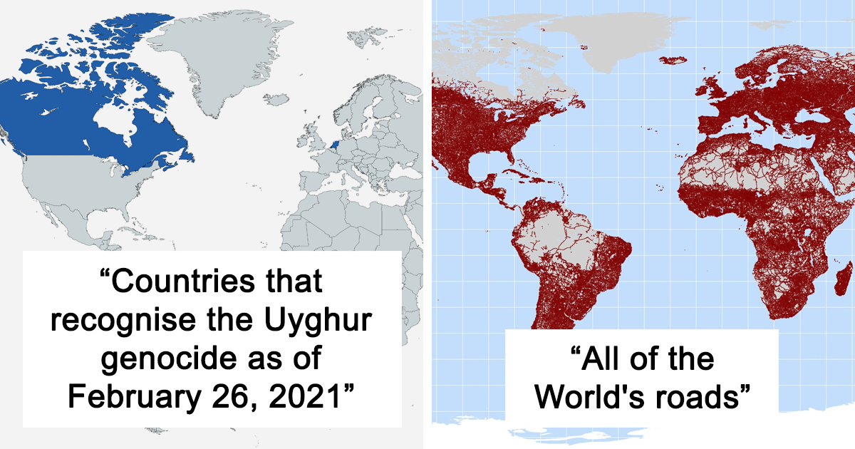
We can’t stop feasting our eyes on gorgeous and interesting maps, and we know that some of you Pandas can’t either. That’s why we’ve put together another list of the coolest content to come from this subreddit that has a dedicated community of nearly 1.4 million fans.

And while we can’t mention the full name of the subreddit (the internet’s gotten a lot stricter in recent years when it comes to certain words! Gosh darn you, internet censorship!), we can tell you all about the project that was started up way back in 2011 by map lover Patrick McGranaghan. What started out as a labor of love has since grown into a dedicated niche for map geeks the world over.

Patrick, the founder of the subreddit dedicated to maps told Bored Panda about how we can improve our spatial awareness and navigational skills. "The older I get, the more I realize that spatial awareness just comes naturally to some people, and for others, it's a struggle," he said, highlighting that practice and repetition are key to honing this skill.

However, just like spell check can make our grammar skills go numb, so can GPS and easily accessible digital maps harm our ability to orient ourselves. "In a way, reliance on Google Maps has made us dumber. We let the navigation app do all the work for us and don't engage with making the decisions," Patrick said. Be sure to read on for the rest of our latest interview with the subreddit's founder, Patrick, below.

In the mood for some more amazing maps? We know you are! When you’re done upvoting your fave maps in this list, check out Bored Panda’s previous posts about the cartography-loving community here, here, and here.

More info: Reddit | Twitter | Tumblr

#1

Oklahoma Man Hole Covers Have A City Map On, With A Blue Dot To Show Where You Are

Oklahoma City map engraved on a manhole cover, showing a detailed street layout perspective.

CatherineCortez Report

RELATED:
    #2

    Map Of Regional Rug Patterns Of Iran

    Map of Iran made from various Persian carpet patterns, showcasing intricate designs and vibrant colors.

    knownothingwiseguy Report

    #3

    Animals Of The World Map

    Animal-themed world map illustration showing diverse wildlife across continents.

    ShapeShiftingCats Report

    #4

    World Map Mural

    Brick world map on worn plaster wall, showcasing unique geographical perspective.

    eveildancer Report

    #5

    Someone Joked That Instead Of Google Earth I Should Make Doodle Earth. I Liked The Idea So I Gave It A Shot

    Hand-drawn world map with intricate blue spiral patterns on a white background, illustrating innovative map designs.

    tfoust10 Report

    #6

    United States Elevation Map

    3D terrain map of the United States showing elevation changes with colorful peaks in the western regions, highlighting informative maps.

    blntdfam Report

    #7

    My Great Grandpa Drew This Map Of Africa In The 1910’s

    Antique map of Africa showing countries and capitals, highlighting historical borders and geographic details.

    zherper Report

    #8

    Europe In The Style Of Super Mario

    Colorful video game-inspired map of Europe with whimsical features, blending geographic and fictional elements to alter perspectives.

    vladgrinch Report

    #9

    Since You All Liked My Great Grandpa’s Drawing Of Africa At Age 12, Here’s One He Did Of Asia (Ca. 1910’s)

    Vintage map depicting historical regions in Asia and Europe.

    zherper Report

    #10

    Abstract World Map

    Abstract geometric map art with colored squares and rectangles.

    CHWDP_2137 Report

    #11

    A Map Of All Of The World's Roads

    Map highlighting global population density areas in red.

    RossBoss31 Report

    #12

    Countries That Recognises The Uyghur Genocide As Of February 26, 2021

    Map showing countries recognizing the Uyghur genocide, highlighting parts of North America and Europe.

    Blulien Report

    #13

    Map Of Most Photographed Places In The World

    World map showing brightly colored data points for informative visualization, highlighting key areas globally.

    the-70s-kid Report

    #14

    The Iberian Peninsula At Night By Nasa

    A nighttime satellite view of the Iberian Peninsula with city lights illuminating the map.

    Homesanto Report

    #15

    An Artists' Impression Of The Roman Port City Of Londinium, Established Between 47-50 Ad

    Illustrated historical map showing a fortified city with a river and bridge, offering a unique perspective.

    last_goodbye1 Report

    #16

    World Map Resized According To Population

    World map resized by population, showing countries like China and India prominently due to their large populations.

    fasterthanksi Report

    See Also on Bored Panda
    #17

    The Roman Empire vs. The Mongol Empire At Their Peaks

    Map comparing territories in red and blue, illustrating different historical regions.

    vladgrinch Report

    #18

    The Island Of Sardinia As Seen From The International Space Station

    Aerial view of a lush, green island surrounded by blue ocean, highlighting geographical map features.

    MXN006 Report

    #19

    Most Popular Lastnames In Europe

    Map showing common surnames across Europe, highlighting diverse naming patterns by region.

    vitor350z Report

    #20

    Place Names That Contain The Word 'Peak', 'Mountain', 'Ridge', 'Plain' And 'Field' In The United States

    Colorful informative map of the United States showing peaks, mountains, ridges, plains, and fields.

    AJgloe Report

    #21

    La Plata.. Buenas Aires.. Argentina

    Aerial view of a city map showcasing intricate street grid patterns and green parks.

    mitozzzzzz Report

    #22

    Every Roman Settlement, And Nothing Else

    Map showing every Roman settlement, highlighting historical geography across Europe and North Africa with numerous red dots.

    ImUsingDaForce Report

    #23

    Ancient Lakes Of The Sahara

    Ancient lakes map of the Sahara region, highlighting historical water bodies across North Africa.

    ZOODUDE100 Report

    #24

    In A Straight Line You Can Go From Belguim To France 11 Times

    Map showing La Flamengrie and Ruainces divided by a red line, highlighting informative geography distinctions.

    Percentagon Report

    #25

    In Which State You Can Find The Highest Percentage Of People With Ancestry From Every European Country?

    Informative map showing US states transposed over Europe to illustrate ancestry perspectives.

    ceskemapy Report

    #26

    The British Empire At It's Territorial Peak

    World map of the British Empire in 1921, highlighting territories in red, showcasing historical colonial reach.

    freddyfredric Report

    See Also on Bored Panda
    #27

    Hand-Drawn Map Of The Polish-Lithuanian Commonwealth In 1618, By Me

    Historical map of Poland-Lithuania with colorful regions, detailed cities, and coat of arms.

    Pochel Report

    #28

    Oldest Still Open Universities In Europe (The Word University Is Omitted On The Map)

    Map showing the oldest still functioning universities in Europe by century, highlighting historical academic institutions.

    efisha Report

    #29

    People Employed In Science And Technology In Europe

    Map showing European employment in science and technology, highlighting percentage differences across regions in 2019.

    betoelpro Report