ADVERTISEMENT
Article created by: Mindaugas Balčiauskas

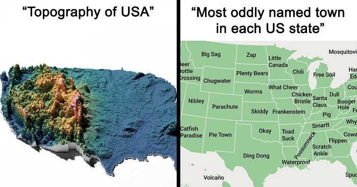
Admit it, once Google Earth was rolled out, you absolutely took a disproportionate amount of time checking out all the localities and areas on it to see if you can find something nostalgic, cool, or flat-out bizarre. And then Google Street View appeared and it was a game changer. Needless to say, you like maps. We’re all nerds like that.

And, well, there’s more to maps than just that. Check out these interesting takes on the US as seen from a top-down perspective, but instead of seeing vast landscapes and the occasional architectural screw-up, you see fun facts and information that might just make you smarter. I mean, it will if it’s not something you already know.

Scroll on.

#1

Topography Of USA

3D topographic map of the US showing elevation and terrain details, related to exploring America maps and geography.

TotherCanvas249 Report

RELATED:
    #2

    Tree Cover Map Of The US

    Map of the US showing vegetation density across the country, part of exploring America maps that shift views.

    DrWendigo Report

    #3

    States With A Smaller Population Than Los Angeles County

    Map of the US highlighting states in blue and one state region in red, illustrating a unique perspective on America.

    SwiftOryx Report

    #4

    More People Live Inside The Red Area Than The Grey Area

    US map highlighting specific counties in red, illustrating unique geographic data for exploring America with detailed maps.

    lex52485 Report

    ADVERTISEMENT
    #5

    Abandoned And Out-Of-Service Railroad Lines

    Map of the US highlighting extensive waterways and road networks, exploring America through detailed geography views.

    StrangeMorris Report

    ADVERTISEMENT
    #6

    Map Showing The Loudest And Quietest Areas In The US

    US map showing noise levels across regions with color-coded decibel ranges, highlighting varied sound intensity patterns.

    Knight1114 Report

    #7

    Countries With Bases In The USA

    Map showing foreign military bases across the United States, highlighting key countries and states, exploring America through maps.

    ActiveHelicopter6644 Report

    #8

    If US Land Were Divided Like Us Wealth

    Map showing US land divided by wealth distribution with regions owning different percentages of the land in America.

    mapsfactory Report

    ADVERTISEMENT
    #9

    United States Population Lines

    3D map visualization of the US showing population density spikes highlighting key areas in exploring America maps.

    AJgloe Report

    ADVERTISEMENT
    #10

    US States Scaled Proportionally To Population Density

    Outline map of the United States showing state borders, part of exploring America through maps that shift your view of the US.

    StarboardCapsized Report

    #11

    Light Pollution In The United States

    Heat map of population density across the US showing urban areas and regional distribution on America maps.

    there_is_no_try Report

    #12

    The Most Efficient Route Between Every Springfield In The United States

    Map of a road trip route across the United States highlighting key cities, ideal for exploring America and travel planning.

    GreenMobius Report

    ADVERTISEMENT
    #13

    US States By Violent Crime Rate

    US map showing violent crime rates per 100k residents by state in 2020, highlighting regional crime variations across America.

    Specific_Ad_685 Report

    ADVERTISEMENT
    #14

    Average Color Of US State Based On Satellite Imaging

    Map of average color of each US state using satellite imagery, visualizing unique regional tones across America.

    SnooMacarons8038 Report

    #15

    US Racial/Ethnic Diversity Map

    Map showing racial diversity percentages across the US states, highlighting variation in diversity levels across America.

    HtxCamer Report

    Never miss a story that brings joy to the world. Follow on Google News

    #16

    Most Popular Dog By US State

    Map showing the most popular dog breeds by state across the US, highlighting labradors and other favorites.

    smooshedeggbog Report

    ADVERTISEMENT
    #17

    Usage Of 'Dang' In The United States

    Heatmap map of the US showing regional data variations with color gradients, exploring America through detailed maps.

    AJgloe Report

    ADVERTISEMENT
    #18

    Map Of The United States' 8 Million Miles Of Roads, Streets And Highways

    Heat map of the United States showing road networks and city lights, highlighting exploring America with detailed maps.

    SkyHawk2112 Report

    #19

    US Obesity Map

    US county map showing 2008 age-adjusted obesity rates with color-coded regions, relevant to exploring America maps and insights.

    Ok_Gear_7448 Report

    #20

    How America Utilizes Its Land

    Map of the US showing land use including timberland, farming, urban areas, and natural preserves exploring America maps.

    reddit.com Report

    ADVERTISEMENT
    #21

    US Territories

    Map highlighting the United States and its territories across the Pacific and Atlantic Oceans for exploring America maps.

    jhseeterlin Report

    ADVERTISEMENT
    #22

    The Most Dangerous Cities In The US

    Map showing the most dangerous cities in the U.S. by violent crime rates per 1,000 residents across different states.

    AdAbject6946 Report

    #23

    Which Coffee Shops Has The Most Locations Per State

    Map of the US showing preferred coffee brands by state, highlighting regional differences in consumer choice across America.

    dannywat3rm3lon Report

    #24

    Highway Signs For Each US State And Territory

    US map showing unique state highway route numbers with various shields and designs, illustrating exploring America maps.

    _HorseWithNoMane_ Report

    ADVERTISEMENT
    #25

    Red And Orange Areas Have Equal Populations

    Map of the US showing regional divisions with highlighted counties and coastlines for exploring America perspectives.

    Cogo5646 Report

    ADVERTISEMENT
    #26

    Origin Of US State Names

    Map of the US showing origins of state names with color codes, part of exploring America maps for deeper insights.

    reddit.com Report

    #27

    Air Traffic Control Zones In The USA

    US air traffic control zones map showing regions including Seattle, Denver, Chicago, Miami, and New York for exploring America with maps.

    lucyeeliza Report

    #28

    Average Money Spent On Weddings In US States

    US map showing average money spent on weddings by state, highlighting regional wedding cost differences exploring America maps.

    Starry_Night0123 Report

    ADVERTISEMENT
    #29

    Here’s A US Map Showing Where Horror Movies Took Place (By Andrew Brick)

    Map of United States highlighting horror movie settings, exploring American locations that might shift your view of the US.

    dixi_annalis Report

    ADVERTISEMENT
    #30

    Purchased Territories Of The USA

    Map highlighting purchased territories of the USA including Alaska, Louisiana, Mexican Cession, Gadsden, and Florida purchases.

    Hockputer09 Report

    #31

    US State Mottos

    Map of US state mottos highlighting language diversity and unique phrases in exploring America through detailed maps.

    Aofen Report

    #32

    Regions Of The U.S. That Don't Officially Celebrate Christopher Columbus Day

    Map of the US highlighting counties that do not celebrate Columbus Day, exploring America with revealing regional data.

    dips9 Report

    ADVERTISEMENT
    #33

    Most Expensive Toll Roads In The US

    Map showing most expensive toll roads to drive end-to-end in the US as part of exploring America with insightful maps.

    ixvst01 Report

    ADVERTISEMENT
    #34

    US States By Wikipedia Article Length

    Map of US states shaded by Wikipedia article length, highlighting variations across regions in the context of exploring America maps.

    Gullyn1 Report

    #35

    The Most Popular Unisex Baby Names By US State (2020)

    Map showing the most popular unisex baby names by state in 2020 across the US for exploring America maps.

    Ganesha811 Report

    #36

    The Safest Cities In The US

    Map highlighting the safest cities in the US by violent and property crime rates per 1,000 residents.

    AdAbject6946 Report

    ADVERTISEMENT
    #37

    US Pronunciation Of Pecan

    US map showing regional variations in pronunciation of the word pecan exploring America with maps that shift your view of the US

    casualiandie Report

    ADVERTISEMENT
    #38

    Most Popular US Female Baby Names 2022

    Map of the US showing most popular female baby names by state in 2022 for exploring America through maps.

    Jakyland Report

    #39

    US Housing Shortage

    Map of the US showing where houses are needed with coastal job centers facing severe housing undersupply.

    Songs4Roland Report

    #40

    Seat Belt Laws In The US

    Map of US seat belt laws by state showing primary and secondary enforcement, part of exploring America maps collection.

    Mangolicious786 Report

    ADVERTISEMENT
    #41

    US States By Human Development Index

    Map of US states by Human Development Index in 2019 showing regional variations and highlighting highest and lowest HDI values.

    untipoquenojuega Report

    ADVERTISEMENT