Get Premium
Dark mode theme is available exclusively for premium users. Learn more about the benefits of subscribing.
No fees, cancel anytime.

 Dark Mode Ad-Free Browsing Unlimited Content
 Ad-Free Browsing Unlimited Content Dark Mode
Join 1.2 million Panda readers who get the best art, memes, and fun stories every week!
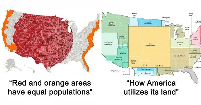
For every Internet commenter who enters online arguments about the USA with facts they got from their butt, there's a map that presents hard data bare and allows the viewers to make their own interpretations.
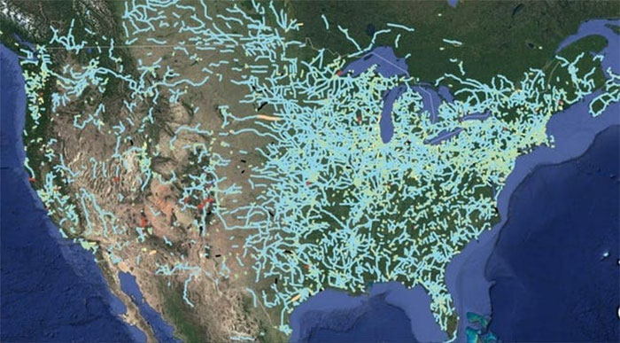
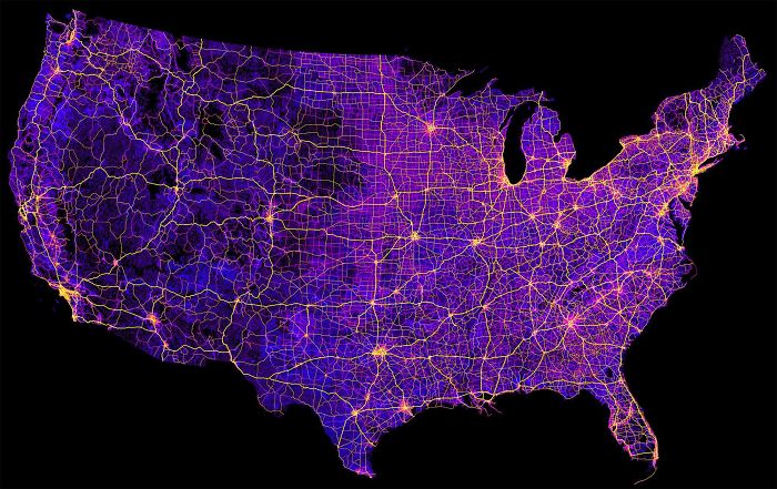
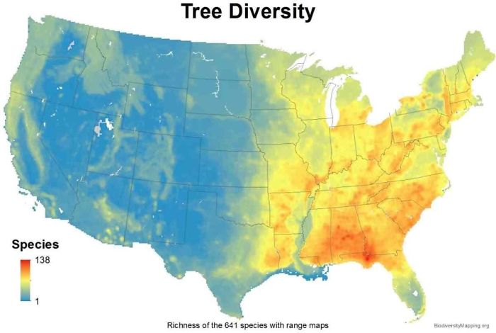
From light pollution and tree coverage to out-of-service railways and streets and highways, maps may not immediately look as exciting as a viral cat video -- which might explain why we often overlook them when -- but that doesn't mean that are boring. To prove that, we put together a selection of maps that explain the United States better then most textbooks and if broadening your worldview isn't thrilling, I don't know what is.
This post may include affiliate links.

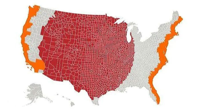
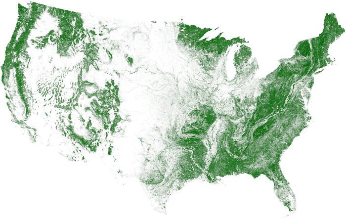
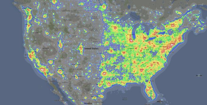
This is not at all surprising, since nearly half the population in this country lives within 30 miles of the coast.

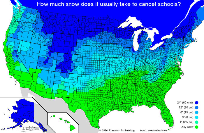
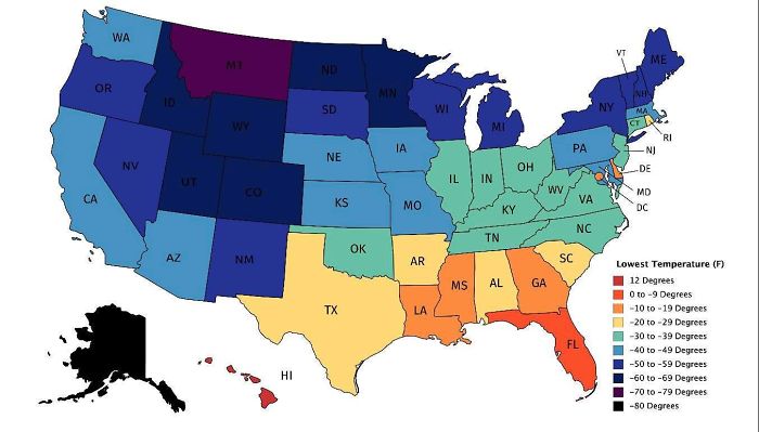
Nice. I always get a kick out of the places that close school for an inch of snow. You don't even need to wear a coat for 1" of snow.

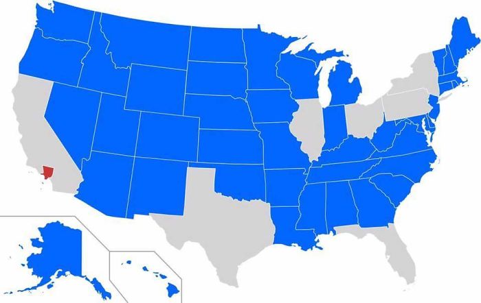
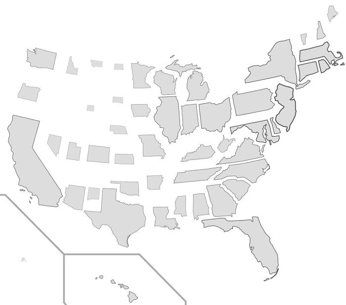
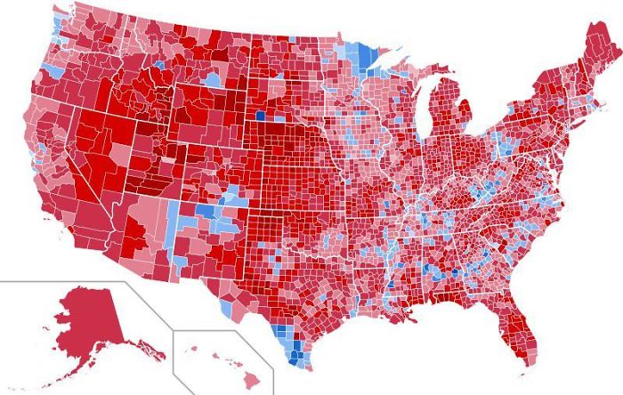
... and this is the downfall of the American election system called the electoral college.

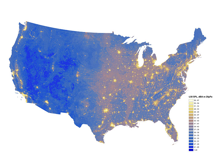
my house is in the border of very loud and very quiet. I can hear trains, a freeway, coyote howls, and owls hooting.


This is Hilarious to me, my ex-husband was raised in Alaska from 7 year's old until 22 year's old & heard a ton of weather stories 😅 😄 😂 😆 🙃 🤣 😅 😄 I've been there 4 time's but alway's in summer though!



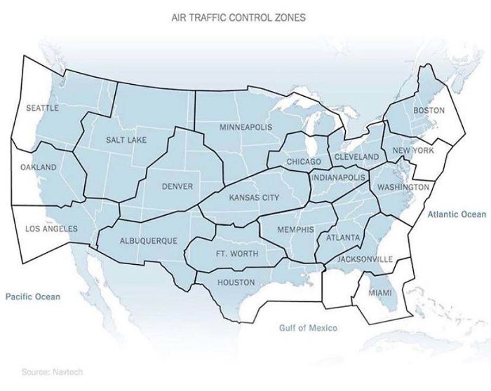
Enroute Center boundaries actually. but Oakland covers nearly the entire pacific ocean.

"Albuquerque Center, Air Force One" "Air Force One go ahead" "Albuquerque, show us now as Special Air Missions 26000." "26000, Albuquerque, roger." Noon, August 9th, 1974.


Scrolling through the maps and I knew what this one was before seeing the heading. I worked ZAU ARTCC.


Those should probably be the states as well. Though I’d hate to have to say I live in Cleveland!
These are en route boundaries. And yes, ZOB (Cleveland center) covers airspace above Detroit. These are buildings, not control towers, where controllers work hundreds of miles of airspace and not just the little airspace around a specific airport like tower controllers.
Load More Replies...

i love how like theres literally just CITIES taking over the air control, and not actual states
Um, Air Traffic Control is run by the Federal Government, the Cities are the zones where the main control center and radar stations are based out for each sector
Load More Replies... Explains why so many US citizens show a heartbreaking ignorance and why a guy like Trump could become president.
In reverse, this must be the outcome of the 2020 election. Trump is setting up the "corrupt election" playbook so that when he loses, he can claim the election was fraudulent. We need to do the same thing Reagan did and OVERWHELMINGLY vote the morbidly obese pathological lying vindictive narcissistic imbecile with the emotional maturity of a toddler (AKA tRump) out of office.

As an American, I would be really interested in seeing maps like these for the UK and Europe.

Ooooh, id love to see that. You could use adoption data. You could also do one by most spent on vet bills and most food and toys purchased.
Load More Replies...

Trump wanted the electoral college defunded because he's against all that fancy edjumacation. His magic 8-ball beats any stupid scientists and their technologeez and advanced mints any day!
Load More Replies...

more, please! Ma, Mom, Mama, Momma, Mother etc; Dad, Pop, Papa, Pa, Father, etc; education - and types of education; sleep patterns; loneliness; favorite fairy tales . . .




Most of those were interesting. The political ones, not so much. People's remarks just get rabid.

Quite annoying that when I entered a comment, you wanted me to log in. After I did so, I was taken back to the top of the story and when I scrolled down to see my comment, it had been disappeared. If it "works as designed", the designers need another needs analysis session.

I enjoy these maps. When we were looking for job interviews in locations we would like to live, we shaded areas color coded for forest, climate and bear habitat, correlated with job openings. Then we constructed a travel plan to interview in those places. It was remarkably effective strategy, and helped us focus our search. Searching by animal habitat was interesting as well.





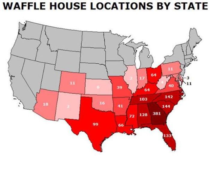
The waffle house map doesn't make sense. The numbers are wrong if this is number of individual stores.

Awesome information. How did they find this information and I can’t find specific information shopping on the internet? I ask for “x” and “a,” “b,” “y,” and “z.”

What great way to show people why we have an electoral college, and why we WONT let California or New York elect our president...
Tyranny to the minority is soo MUCH better than tyranny to the majority. /s
Load More Replies...

Pro tip; if you want people to take you seriously, learn how to spell
Load More Replies...
None of this had anything to do with that. If you're going to take a poke at us, at least make it relevant.
Load More Replies... I don't think you realize how large the United States is. Many of our states are larger than European countries.
Load More Replies...

The name of the continent is North America. Even if one accepts the argument that N and S America are a single continent, the accepted demonym for citizens of the USA is "American".
Load More Replies... As an American, I would be really interested in seeing maps like these for the UK and Europe.
Ooooh, id love to see that. You could use adoption data. You could also do one by most spent on vet bills and most food and toys purchased.
Load More Replies... Trump wanted the electoral college defunded because he's against all that fancy edjumacation. His magic 8-ball beats any stupid scientists and their technologeez and advanced mints any day!
Load More Replies... more, please! Ma, Mom, Mama, Momma, Mother etc; Dad, Pop, Papa, Pa, Father, etc; education - and types of education; sleep patterns; loneliness; favorite fairy tales . . .
Most of those were interesting. The political ones, not so much. People's remarks just get rabid.
Quite annoying that when I entered a comment, you wanted me to log in. After I did so, I was taken back to the top of the story and when I scrolled down to see my comment, it had been disappeared. If it "works as designed", the designers need another needs analysis session.
I enjoy these maps. When we were looking for job interviews in locations we would like to live, we shaded areas color coded for forest, climate and bear habitat, correlated with job openings. Then we constructed a travel plan to interview in those places. It was remarkably effective strategy, and helped us focus our search. Searching by animal habitat was interesting as well.
The waffle house map doesn't make sense. The numbers are wrong if this is number of individual stores.
Awesome information. How did they find this information and I can’t find specific information shopping on the internet? I ask for “x” and “a,” “b,” “y,” and “z.”
What great way to show people why we have an electoral college, and why we WONT let California or New York elect our president...
Tyranny to the minority is soo MUCH better than tyranny to the majority. /s
Load More Replies... Pro tip; if you want people to take you seriously, learn how to spell
Load More Replies... None of this had anything to do with that. If you're going to take a poke at us, at least make it relevant.
Load More Replies... I don't think you realize how large the United States is. Many of our states are larger than European countries.
Load More Replies... The name of the continent is North America. Even if one accepts the argument that N and S America are a single continent, the accepted demonym for citizens of the USA is "American".
Load More Replies...






























 No fees, cancel anytime