Get Premium
Dark mode theme is available exclusively for premium users. Learn more about the benefits of subscribing.
No fees, cancel anytime.

 Dark Mode Ad-Free Browsing Unlimited Content
 Ad-Free Browsing Unlimited Content Dark Mode
Join 1.2 million Panda readers who get the best art, memes, and fun stories every week!
Spending a Friday night in a sewer may not be to everybody's tastes, for obvious reasons. To a photographer, however, the wonders that lay beneath the ground can offer unique environments that are both fun to explore and incredible subjects to light. A cross-section of most cities would reveal all manners of engineering projects; buried rivers, service tunnels, reservoirs, sewers, air-raid shelters, and who knows what else. All either disused or quietly and modestly fulfilling their intended purposes in the dark, too deep in the earth for the rays of glory to reach them.
We are able to look up at the world around us and the worlds above us, but what lies beneath us is, for the most part, hidden out of sight and out of mind. This can leave us with the false impression that we are standing on solid ground, when in fact millennia of human activity has bored more holes through the earth than we could ever be aware of. At the time when these structures become obsolete, it isn't practical to demolish and replace them, like their cousins on the surface. They are often capped off and left for the next generation to deal with, becoming the tombs of the ideas and technologies that formed them.
Taking some time to learn about the subterranean delights beneath your feet can add another fascinating dimension to your perception of the world in which you live. Let's shine some light through the portal and take a look at a few examples of what can be found. Subterranean exploration comes with significant risk. Don't attempt to enter any holes in the ground without being aware of the dangers.
More info: Instagram | Facebook | markoneill.co.uk
This post may include affiliate links.
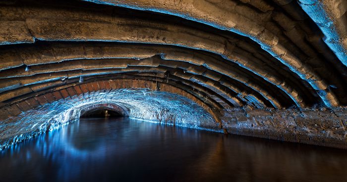
The reason behind the catchy title coined by urban explorers becomes obvious when one wades into this vast flood-relief chamber on the River Sheaf in Sheffield; its scale is enormous.
The 19th century brought rapid growth from the development of industry in Victorian Sheffield. As a result of this, the temperamental River Sheaf became a foul, polluted waterway, often in spate and suitable only for the running of mills. The growing requirement for land in the industrial city center slowly concealed this ugly stream, as a number of buildings were constructed over it.
By the turn of the 20th century, most of the urban river had been consumed in a series of tunnels underneath what included the Midland railway station, a power station, a forge, and Victorian markets. The lower section just upstream of the Sheaf's confluence with the River Don was one of the last sections to be culverted and received a large single—span brick arch, leaving an enormous cavern beneath Castlefield.
So we have all heard about the eye of the storm but here is the eye of a river cum portal to another world. A splendid photo.
Flowing beneath the hamlet of Wadesmill in Hertfordshire is a small stream known as the Upper Bourne Stream. The brick culvert here was constructed sometime before the 1880s, its course suggests it was originally built over by a farm; more recently by a housing estate. The covered section of the stream flows for just a couple of hundred meters in a round brick pipe, then through varying, modern precast concrete sections before its outfall into the River Rib. Although this stream may appear to be little more than a trickle, the water level can rise significantly with no notice. This can make the conditions treacherous and quite unpleasant to experience if you are inside at the time. Even a small increase in flow can drastically reduce the grip of your boots on the slippery brickwork, so a fall would be difficult to get back up from.
One of the few disused rail tunnels in my area, this 520-meter tunnel served a small branch line linking two towns. Its traffic gradually declined between the wars until much of the track was lifted in the 1960s, after one hundred years of use.
Now used as a sanctuary for rare bats and off-limits to most visitors, the winding blue-brick tunnel is preserved with the possibility that the line may reopen in the future.
Holding the title of the UK’s highest railway tunnel, the Torpantau tunnel cuts through the rock of the Taf Fechan Valley and emerges above the Talybont Reservoir on the former line between Merthyr Tydfil and Brecon. Despite the line being lifted on the eastern side of the tunnel, much of the line still operates with steam trains as the Brecon Mountain Railway between Merthyr and Torpantau station, a short distance below the tunnel’s eastern portal. The regular whistles of the steam trains become familiar sounds to anybody who has visited the area.
Tucked away in the hillside, the attractively overgrown and flooded portal is easily overlooked when walking through the eye-catching landscape of the Brecon Beacons, however, its interior is no less beautiful than its surroundings. The moss and mineral deposits that its walls have become adorned with have matured to form some remarkable textures over the last century or so. The tunnel is reasonably safe to the cautious explorer and makes for an excellent adventure if you are brave enough to get your feet wet.
top tip for this tunnel is to pick up one of the sticks placed at the entrance and use it in your right hand to feel along the wall- no need for a torch; watch out for the enclaves designed as escape spaces should a train be coming.
It is believed that the monks of Reading Abbey dug, or extensively managed a side-stream branching from the River Kennet to power two mills, which earned it the divine name of the Holy Brook. As the town expanded from the late 18th century onwards, sections of the watercourse were covered over in favor of development.
Flowing through the site of the Simonds Brewery, the clean water of the brook was hidden from view within a brick culvert that runs over half a mile under the town center. Remnants of this era are common finds in the form of flagons and beer bottles nestled amongst the silt of the riverbed.
Further development of the area in the mid-1990s, brought the installation of a modern, corrugated steel lining beneath the land occupied by the Oracle shopping center, which presents a particularly challenging obstacle to move over.
This compact, brick reservoir was constructed in the late 1800s to supply a small market-town with drinking water. It was soon joined by three others as the town's population and infrastructure grew.
Like many others of the era, it became disused in the 1970s when a modern concrete reservoir with a larger capacity was built to replace it. Since then it seems the hatch to the chamber had seen few visitors, except for a lonely slow worm who seemed happy enough living in apparent solitude.
I love the well-written texts accompanying the photos. Very few people nowadays ever think about where the drinking water comes from before it streams out of the tap. Actually, some probably think that it comes from the supermarket...What an astonishing marketing feat! They managed to sell, and at a very inflated price, what consumers already had at home, flowing freely and costing next to nothing!
This view was unexpected when visiting a historic culvert beneath the center of Oxford. Rather than be faced with age-old brickwork, the builders of a new shopping center were still laying replacement sections of this box culvert just around the corner as I captured this photograph.
The original medieval sewer is famed for being navigated by T.S. Elliot; Lawrence of Arabia, who took a canoe along the course of the mill stream by the light of candles and acetylene lamps whilst studying at Oxford University in 1908.
A local urban legend claims that just over a decade later, a Victorian punt was discovered containing the skeletons of three other adventurers who had not shared the same success, falling victim to the toxic fumes of the medieval sewer.
The soldier Lawrence of Arabia is T.E. Lawrence, not the poet T.S. Eliot (not Elliot anyways). So which of the two? In 1908 Lawrence was in Oxford but Eliot in Harvard so probably the first, if true... Also, Lawrence was an adventurer.
This covered reservoir was one of several constructed in 1914-1915 to supply the nearby town and barracks at Aldershot with drinking water during the first world war. Four large cisterns with a huge capacity were built at this site and operated until they were replaced with a modern reservoir in the 1980s. Since that time, they have been obscured from view by a mass of brambles.
Breaching the hatch into space revealed a damp world of stalactites and a vaulted ceiling with steel supports. The circular structure also brings seemingly perpetual echoes that can become almost nauseating after some time.
The threat of invasion is something that the town of Dover has become accustomed to, being England’s closest point to mainland Europe. This was especially so during the Napoleonic wars with France, at which point a hill overlooking the coastal town was being transformed into a formidable citadel to guard the gateway to Britain.
Rapid access to the seafront was required by the thousands of troops stationed in the barracks above the white cliffs, in order to fend off an attack. An ingenious solution devised by military engineer General Twiss proposed to sink a triple spiral staircase and central light well, through 140’ of chalk. This allowed the troops to pour out onto the beaches below when French warships were inbound. Construction began in 1806 and lasted for roughly three years due to being plagued by wet ground.
Never really used in anger, the aptly named Grand Shaft fell disused with the demolition of the barracks above in the 1960s. After decades of neglect, it has been partly restored under the care of the Western Heights Preservation Society, who permit access on certain days of the year.
The photos are so good that they require your brain to set them in a different context to where they were actually taken. This has to be some kind of wormhole. I wonder where, and in what era, the person whirling through it will finally find himself, or herself?
In an upstream section of the aforementioned waterway, the Holy Brook bears a fascinating secret which many of the town's inhabitants are quite unaware of.
Ribs of stone coping span the arch, in contrast to the usual red brickwork found elsewhere in the culvert. Old maps reveal this part had been constructed in the late 18th century, sometime after the dissolution and destruction of Reading Abbey by King Henry 8th.
There have been suggestions that the abbey ruins left a surplus of stone available to be repurposed elsewhere in the town and it could have been used here. The stone certainly looks to have originated from a historic building before being reused in the culvert, but the theory that it originated from the Abbey remains unproven after an archaeological survey.
Burrowed into the white cliffs of Dover are many deep-level shelters from the early days of the second world war when an Axis invasion of Britain was an imminent threat. This typical example served the crews of a Z-Rocket battery built-in 1940-41 which would have fired a vertical barrage of rockets at enemy aircraft as they crossed over the coast of England.
Descending some 65' into the ground, the network of tunnels would have provided secure refuges in the event of bombardment and multiple exits would ensure that its inhabitants would not become trapped inside.
The main entrances to the tunnels were demolished soon after the war and rapid coastal erosion now threatens access.
A reversed view of the ’Megatron’ flood relief chamber seen previously, this image shows the contrast of the materials used in the culvert’s construction. The ashlar stone section in the foreground is, in fact, the remains of an old bridge on Exchange Street, which was incorporated into the arch of the culvert when the river was covered over in the early 20th century.
Visible behind my silhouette is the glow of the culvert’s outfall, where the Sheaf converges with the River Don. The proximity to the open river allows for all kinds of fauna to make their way into the darkness of the tunnels, including various species of bats, fish, and crustaceans, so care must be taken not to step on any critters in the water.
"...care must be taken not to step on any critters in the water." This does not sound even half as menacing as "care must be taken not to awaken any creatures in the water".
The local iron, coal, and steelworks of Merthyr Tydfil were connected to the rest of Wales and the UK by spectacular railways carved through the rugged landscape at the heads of the valleys.
Many of the lines which carried heavy freight from the coalfields saw decline post-WW2 until their eventual closure, leaving a trail of grand viaducts and gaping tunnels. This line to Abergavenny was slowly wound down until it closed to passenger traffic in 1971.
Three shafts were sunk into the limestone to expedite the construction of this kilometer-long tunnel, which later allowed for the distribution of fresh air along its length. The application of light on the deluge pouring through one of these shafts creates an unusual effect on a long exposure.
Code named Objekat 505, the Yugoslav Air Force base at Željava was a $6 billion facility bored into the base of Plješevica mountain; straddling the border between Croatia and Bosnia and Herzegovina.
Designed to withstand a 20 kiloton nuclear blast, the facility provided shelter and maintenance areas for two fighter squadrons and a reconnaissance squadron using variants of the MiG-21.
Aircraft could exit the underground hangars and taxi directly onto the runway through a 100-ton sliding blast door and portal with a slot to accommodate the tail fin. The surrounding facility was sufficiently sophisticated to be able to sustain its staff, aircraft, and operations for up to 30 days without resupply.
The underground section of the airbase was largely destroyed during the Yugoslav wars when the retreating Military of Serbian Krajina detonated 56 tons of explosives in an attempt to prevent its use by opposition forces.
This enormous, circular reservoir was designed by Sir William Thomas Denison in the mid-1800s, costing a total of £3069. Its purpose was to serve the local area and hospital with clean water, with a volume great enough to cover the requirements of the London fire-brigade.
Located within a green park of East London, the immaculate structure appears to have been disused for many years. Consisting of several concentric arched rings, supported by brick pillars, this incredible space produces acoustics that reverberates any sound. Even the rustle of your jacket can echo for some time, so it is pointless trying to have a conversation down here.
The entrance to the reservoir has since been filled with concrete, rendering it quite inaccessible.
This view shows the internal workings of a twin 135mm mortar bunker on the Maginot Line in France. The weapon, built in a retractable turret with adjacent observation posts and machine-gun cupolas, was virtually immune to enemy fire when not in use, but devastating when deployed. The engineering of the Maginot line has a certain art-deco appearance to it and due to its well-considered, mechanical design, many of these positions are easily restored to working order.
As the bunker was impenetrable from the surface, access to this gun block is via the main entrance and through several kilometers of tunnels. This subterranean network would supply the position with rations, munitions, and personnel, from 30m below the ground. Few seem to venture this deep into the fortress, this is evident by the amount of life and spent ammunition that can be seen on the floor.
For a railway crossing such a small stream, this seems like an unnecessarily large culvert; such is the splendor of Victorian engineering. Flowing beneath an elegant arched viaduct on the GNR & LNWR railway line between Nottingham and Northampton, it appears the local topology around Loddington required the Eye Brook to be submerged beneath the land in a brick and stone culvert. Crossing the line at an oblique angle, the culvert continues for around a quarter of a mile below the grassy fields of Leicestershire.
Never a busy line, to begin with, the tracks above were lifted after the line closed to traffic in 1964 then the attractive viaduct was demolished in 2001. Forgotten beneath the ground, the well-built brick and stone arch still carries the Eye brook through the quaint valley where more than a one hundred years’ worth of mineral deposits can be seen spewing through inlets in the tunnel walls.
The London Blitz brought a requirement for the British Government to relocate the GHQ Home Forces communication facilities from Whitehall to a remote site, away from the destruction of the city.
A quiet country house with a surrounding golf club was chosen for the site of the new signals bunker, consisting of two parallel tunnels 100m long, linked by a service tunnel between.
The signals facility was later used as the Rear HQ of the Supreme Headquarters Allied Expeditionary Force and became a major component in the planning of the Allied invasion of France in June 1944. With the success of D-Day, staff followed-up onto the continent, leaving the bunker vacant and without purpose.
The empty tunnels can now be found beneath the golf-course car park but any access routes have been sealed.
Again in the Victorian reservoir beneath London, the passing of light over the brick columns reveals another view, showing the circular structure of the reservoir to be quite different from that of other reservoirs of the era. The circumference of the space measures around 220 meters, with a capacity of 1,125,000 gallons of water; dwarfing even the largest of swimming pools.
It has been difficult to determine how long the reservoir has sat dormant for, but with the 1871 closure of the nearby hospital it was built to supply, it is possible that no water has passed through its valves ever since. To consider that the structure is over 150 years old is quite amazing when it is still so immaculately preserved.
Wow!! It looks like it could have been built in the last 10-20 years. It's beautiful.
During the interbellum, amidst the aftermath of the first world war, French Minister of War André Maginot advocated the construction of a network of fortifications to run parallel to the German Border. This colossal feat of engineering was an attempt to prevent the grim horrors of trench warfare, should the Germans ever invade again.
Ranging from small gun positions to giant fortresses called 'Ouvrages', the defenses of the Maginot line were often interconnected by a network of deep tunnels that could supply troops and ammunition via narrow-gauge railways.
Although some parts of the line were involved in a fierce battle during the German invasion in 1940, the German forces effectively bypassed the defenses by Invading France through Belgium, taking the country in only six weeks.
This photograph shows the munitions entrance of a large Ouvrage in the Alsace-Lorraine region, with the railways leading into a vertical lift shaft, taking them thirty meters below the surface to the deep-level of the fortress. Machine gun emplacements like those on the far wall are commonplace at nodal points throughout the fortress.
Standing at one of the sliding blast doors at the entrance to the Željava Air Base in Croatia, the force of the blast that destroyed the facility is quite plain to see. The 56 tons of explosives laid by the retreating army of Serbian Krajina parted the 2” steel rebar like lace, tore the 100-ton door in two and sent half of it into the opposite wall of the tunnel, some 20 meters away. Locals have said that the ground shook violently for miles around and black smoke poured from the mouths of the tunnels for six months after the event.
The hazards in this location pose a threat to visitors like no other in this article. Landmines litter the grasslands of the airfield and woods of the mountain above; toxic chemicals line the collapsing walls underground and munitions lie scattered across the floor. Bears are frequent visitors here, often hanging around over winter to hibernate in the steady climate of the tunnels. Furthermore, the destruction of a large number of smoke detectors has dispersed traces of the radioactive element Americium throughout. The dangers present are not to be underestimated and it’s quite likely the Croatian Police will be there when you arrive, to remind you of that.
As the Germans dug in on the far shores of the English Channel, Hitler’s Atlantik Wall was bolstered by the construction of a gargantuan Naval gun battery on France’s north coast in 1942. Batterie Todt consisted of four 380-millimeter guns protected by concrete casemates with walls a whopping 3.5 meters thick. The guns each had a range of 55km; making them quite capable of throwing their shells over the channel, to plant them in the garden of England.
Three of the huge bunkers have been abandoned since the war and one is now being used as a museum with some interesting exhibits from the period. Beneath the gun emplacements are extensive underground magazines with doorways shaped to fit the enormous 15-inch shells; traversed along with the ceiling on rails as they headed towards the breech. A human silhouette gives some sense of the scale of these fearsome projectiles which rained upon Kent until the battery’s capture in September 1944.
Until the 1850s, London’s sewerage system consisted of the unregulated dumping of effluent into the River Thames or any other watercourse that would wash it away. An unsurprising rise in disease, including recurring cholera epidemics, added pressure on the authorities to take action against the growing number of deaths. Piles of sewage lined the river banks for decades until the ‘big stink’ in July of 1858. An unusually hot summer brought a heatwave which lifted the aroma of the raw sewage to a level unbearable by the city’s population. The false belief that cholera originated in sewage and was spread through the atmosphere in a ‘miasma’ led to the realization that something had to be done to solve the problem.
A proposal from an engineer named Joseph Bazalgette was accepted, which would have London equipped with interconnecting pipes, draining the sewage into East London, where it would be treated and released into the Thames, downstream of the city. The mammoth project ran from 1859-1875 and created some of the most wonderful structures of the Victorian age, such as Abbey Mills Pumping Station. Bazalgette would later be heralded as a hero for saving an immeasurable number of lives (albeit through dispersing the pathogen, not the miasma) and for pioneering a system that would later be adopted by cities across the world.
This photograph shows the intersection of two streams of sewage in a combined sewer overflow; designed to collect and divert rainwater runoff to prevent the main system from being overloaded. The beautiful brickwork of the sewer here is preserved as well as the day it was laid.
This cute bunker from the second world war would have provided accommodation for the crews of an early type of RADAR system on the south coast of England. The position is located just a stone's throw from where the Chain-Home early-warning system was pioneered, at RAF Langston Matravers in Dorset.
Aerials positioned on the top of the hill would detect incoming aircraft then transmit information to crews in protected bunkers nearby. One of these structures have been repurposed to house mobile antenna switchgear, whilst this bunker now shelters the sheep and cows of the nearby farm.
In an area famous for its stone mining industry and resultant caverns, the British government planned to utilize a series of disused mines for the storage of large volumes of RAF munitions in WW2 before their onward journeys to Germany. The chosen site at Monkton Farleigh provided a pre-tunneled area of 80 acres, which when complete, became the largest Central Ammunition Depot in the UK.
Served by six discrete entrances on the surface, the depot had a 1.25-mile tunnel constructed for the safe and inconspicuous movement of munitions from nearby railway sidings on the UK mainline. A long conveyor belt carried the ordnance up the length of the inclined tunnel towards the enormous storage districts.
This view shows the underground sidings and sorting yard and the bottom of the tunnel, where the munitions would be loaded from trains onto wagons, then onto the conveyor belt on their way into storage. At its peak, the yard was able to process up to 1000 tons of ordnance each day. This figure helps give some scale to the massive depot which is now used for secure data storage.
Very cool pictures - I would love to explore all of those places!. I took a hike to the Old Cascade Tunnel here in Washington - which is a collapsed/abandoned train tunnel and site of the Wellington Avalanche in 1910. It was otherworldly being alone in that tunnel with the lost souls from a previous century. 20190616_1...8e33a5.jpg 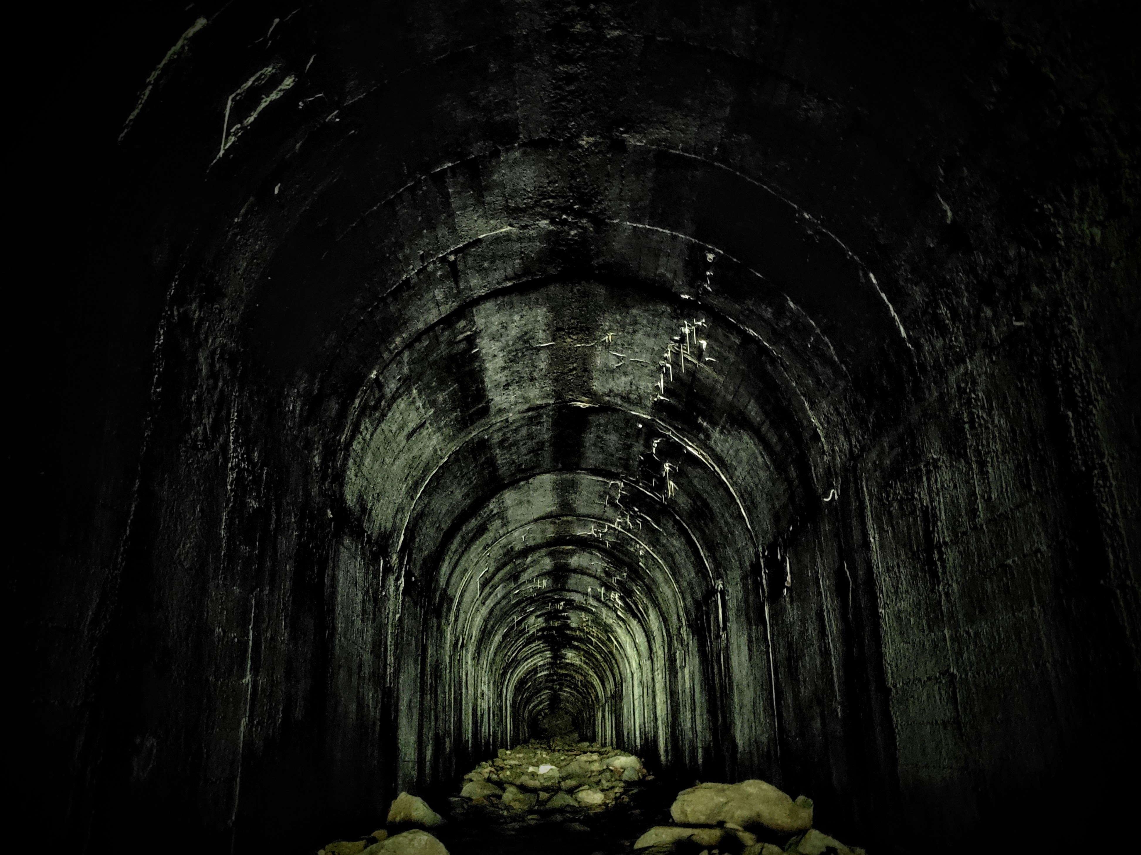
Another of Dover’s deep-level air raid shelters, this tunnel was dug in 1941 for the crews of a coastal artillery battery positioned on the cliffs to the West of the town. Designated a fortress in itself, this battery consisted of three 6” naval guns with a range of 24 km. With regular incoming fire from across the channel, the shelters saw frequent visitors during the first years of world war two.
As with the Z-Rocket Deep Shelter and so many other shelters in the area, the tunneling was performed by the 172nd Tunneling Company using steel girders and sheeting to line the walls. Still busy digging into WW2, this company had been made infamous by the heroic mining raids of WW1, quietly tunneling under the german lines to destroy and disorientate their enemy from below.
Since the entrances to the shelter were bulldozed, only the emergency escape route remains accessible. The small, backfilled and partially collapsed tunnel is located on a sheer and deadly cliff face, overlooking the sea.
I must admit that I did not expect this to be at all what it is. The photos are great, many of them have these qualities to them that send your imagination off running in some rather enjoyable science fiction directions and the texts that explain what we are actually seeing in the photos are both well written and very informative which certainly add a lot. Great work! Do you take people along?
Thanks Monika, I like to work alone but this is not always possible or safe. Many of these images are made with the help of my friends, who have to stand still for quite a long time while I light the scene.
Load More Replies...I must admit that I did not expect this to be at all what it is. The photos are great, many of them have these qualities to them that send your imagination off running in some rather enjoyable science fiction directions and the texts that explain what we are actually seeing in the photos are both well written and very informative which certainly add a lot. Great work! Do you take people along?
Thanks Monika, I like to work alone but this is not always possible or safe. Many of these images are made with the help of my friends, who have to stand still for quite a long time while I light the scene.
Load More Replies...


 No fees, cancel anytime