ADVERTISEMENT

Since 2014, Benjamin Grant searches for striking satellite pictures of our planet and publish them on his website - The Daily Overview. His aim is to change the way we see our planet Earth, and to show the effects of human intervention that can be found in nature - desserts, mining fields, islands and etc. Do you remember his previous post on Bored Panda?

Grant was inspired by the Overview Effect experience, which is a cognitive shift of perspective and worldview experienced by the astronauts when they see the planet Earth from space for the first time. In that breathtaking moment, astronauts realize how small and fragile the human life is.

So scroll down the page and experience the Overview Effect yourself!

More info: dailyoverview.com | Instagram

#1

The Blooming Tulip Fields In Lisse, Netherlands

The Blooming Tulip Fields In Lisse, Netherlands

Check out this Overview, which captures the blooming tulip fields in Lisse, Netherlands. These vibrant flowers are at their peak in April of each year

Benjamin Grant Report

Add photo comments
POST
Sage Jay
Community Member
6 years ago DotsCreated by potrace 1.15, written by Peter Selinger 2001-2017

the Netherlands is probably my favorite country. So beautiful and accepting

Kath Leen
Community Member
6 years ago DotsCreated by potrace 1.15, written by Peter Selinger 2001-2017

abstract painting on a large canvas....very large canvass...

Kjorn
Community Member
6 years ago DotsCreated by potrace 1.15, written by Peter Selinger 2001-2017

it's like watching a adult movie in a forbidden channel when we were kids

View more commentsArrow down menu
RELATED:
    #2

    Northumberlandia, Or “Lady Of The North”, Northern England

    Northumberlandia, Or “Lady Of The North”, Northern England

    Northumberlandia, or “Lady of the North,” is a massive land sculpture in the shape of a reclining female figure near the town of Cramlington in northern England. Completed in 2012, the sculpture is made of 1.5 million metric tonnes of earth removed from the neighboring Shotton Surface Mine. It is 112 feet (34 m) high and 1,300 feet (400 m) long

    Benjamin Grant Report

    Add photo comments
    POST
    Elizabeth Molloy
    Community Member
    6 years ago DotsCreated by potrace 1.15, written by Peter Selinger 2001-2017

    Oooh! This is near me! Must go and visit when the weather is nicer :D

    Mark Jaress
    Community Member
    6 years ago DotsCreated by potrace 1.15, written by Peter Selinger 2001-2017

    1,000 years from now, archeologists will ruminate on the pagan religion those ancient Brits worshiped back then

    Dian Ella Lillie
    Community Member
    6 years ago DotsCreated by potrace 1.15, written by Peter Selinger 2001-2017

    Paganism, archaeology, mine-site rehabilitation, art... I'm fit to burst with the confluence of things about which to feel so much joy!

    View more commentsArrow down menu
    #3

    Willie Creek, Western Australia

    Willie Creek, Western Australia

    Willie Creek is a protected tidal estuary roughly 10.5 miles (17 km) north of Broome, Western Australia. The creek’s calm, nutrient-rich waters make it an ideal habitat for the Pinctada maxima oyster, which produces world-renowned pearls

    Benjamin Grant Report

    Add photo comments
    POST
    Hans
    Community Member
    6 years ago DotsCreated by potrace 1.15, written by Peter Selinger 2001-2017

    This could also be a microscope photo in 1000x enlargement...

    View more commentsArrow down menu
    ADVERTISEMENT
    #4

    Everglades National Park, Florida

    Everglades National Park, Florida

    Everglades National Park in Florida is the largest tropical wilderness in the United States east of the Mississippi River, covering more than 1.5 million acres. The park was established in 1934 to protect the area’s fragile ecosystem and is home to 36 threatened or protected species including the American crocodile and West Indian manatee

    Benjamin Grant Report

    Add photo comments
    POST
    Magdalina777
    Community Member
    6 years ago DotsCreated by potrace 1.15, written by Peter Selinger 2001-2017

    That looks abstract o: Am confused. What's the yellow/orange/red stuff? Would guess river but colour is wrong

    GB1997
    Community Member
    6 years ago DotsCreated by potrace 1.15, written by Peter Selinger 2001-2017

    I was highly confused to, I'm assuming it was a satellite picture taken at sunset or sunrise?

    Load More Replies...
    Dian Ella Lillie
    Community Member
    6 years ago DotsCreated by potrace 1.15, written by Peter Selinger 2001-2017

    Sadly this is now an endangered ecosystem. One day sea level rise from global warming will pretty much flood most of the Everglades...

    Sage Jay
    Community Member
    6 years ago DotsCreated by potrace 1.15, written by Peter Selinger 2001-2017

    honestly that looks like it was colored in by Copic markers!

    View more commentsArrow down menu
    #5

    Plaza Del Ejecutivo, Mexico City

    Plaza Del Ejecutivo, Mexico City

    Radiating streets surround the Plaza Del Ejecutivo in the Venustiano Carranza district of Mexico City, Mexico. This district — which is home to more than 430,000 people — contains three of Mexico City’s large traditional markets, including La Merced, Mercado de Sonora, and Mercado Jamaica

    Benjamin Grant Report

    Add photo comments
    POST
    Amazon QT
    Community Member
    6 years ago (edited) DotsCreated by potrace 1.15, written by Peter Selinger 2001-2017

    This is so the Darhma Initiative or the Umbrella Corporation.

    Radityo Bagus
    Community Member
    6 years ago DotsCreated by potrace 1.15, written by Peter Selinger 2001-2017

    Then, I think it's safe to assume where the zombie outbreak will happen in the future....

    Load More Replies...
    Ladies and Gentlemen
    Community Member
    6 years ago DotsCreated by potrace 1.15, written by Peter Selinger 2001-2017

    What an amazing city planning. Though the contrast of image is bit hurting eyes, but still i looked at it for too long.

    Tolga ÜSTÜN
    Community Member
    6 years ago DotsCreated by potrace 1.15, written by Peter Selinger 2001-2017

    That "everybody is looking at you" feeling when you live in the center...

    ADVERTISEMENT
    #6

    Cluster Of Tetrapods, Hong Kong

    Cluster Of Tetrapods, Hong Kong

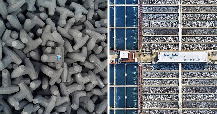
    A cluster of tetrapods is seen near the High Island Reservoir in Hong Kong. These concrete structures are used to reinforce shoreline defenses and prevent coastal erosion by breaking up incoming waves. The specific shape of the tetrapod allows water to flow around rather than against the concrete and reduces displacement by interlocking

    Benjamin Grant Report

    Add photo comments
    POST
    Ladies and Gentlemen
    Community Member
    6 years ago DotsCreated by potrace 1.15, written by Peter Selinger 2001-2017

    Honestly, this looks like more of a drone photo, instead of satellite!

    Board Pan, duh.
    Community Member
    6 years ago DotsCreated by potrace 1.15, written by Peter Selinger 2001-2017

    Ok what! This photo is intriguing..... And I agree, looks like a drone shot! I have never heard of these structures..... This was the thumbnail that got me to check out this post, though ;)

    Kath Leen
    Community Member
    6 years ago DotsCreated by potrace 1.15, written by Peter Selinger 2001-2017

    this dont look like big tetrapods...the guy looks like a small human figurine...XD

    S Atherton
    Community Member
    6 years ago DotsCreated by potrace 1.15, written by Peter Selinger 2001-2017

    This is a drone shot. Hes holding the controller in his hand.

    Amazon QT
    Community Member
    6 years ago DotsCreated by potrace 1.15, written by Peter Selinger 2001-2017

    Looks like a Ken doll laying on some weird rock formations.

    BusLady
    Community Member
    6 years ago DotsCreated by potrace 1.15, written by Peter Selinger 2001-2017

    Well, we're all dying to know: How did he get out there?

    View more commentsArrow down menu
    ADVERTISEMENT
    #7

    Sahara Desert, Algeria

    Sahara Desert, Algeria

    The climate in this region is torrid and almost rainless, with an average annual rainfall of less than 0.4 inches (10 mm). In the summer, daytime temperatures are known to consistently reach 122°F (50°C), earning this area its nickname — the “triangle of fire”

    Benjamin Grant Report

    Add photo comments
    POST
    Kath Leen
    Community Member
    6 years ago DotsCreated by potrace 1.15, written by Peter Selinger 2001-2017

    i have no words for this...looks beautiful, terrifying, mysterious...somewhere between those

    Daria B
    Community Member
    6 years ago DotsCreated by potrace 1.15, written by Peter Selinger 2001-2017

    But to staaand with you in a ring of fire, I'll forgeeeet the days gone by... I'll protect your body and guard your so-oh-ul - from mirages in your siiiiiight. (Lost out in the desert, desert, desert, desert...) ♬♪

    #8

    Kawah Ijen, Indonesia

    Kawah Ijen, Indonesia

    Kawah Ijen is a stratovolcano in the East Java Province of Indonesia. It has a 0.6-mile-wide (1 km) turquoise-colored acidic crater lake, which is the site of a major sulfur mining operation. At night, when sulfuric gases make contact with fresh air, electric blue flames can be seen rising from volcano up to 16 feet (5 m) high

    Benjamin Grant Report

    Add photo comments
    POST
    Ladies and Gentlemen
    Community Member
    6 years ago DotsCreated by potrace 1.15, written by Peter Selinger 2001-2017

    I have trekked to core of this volcano.. and you have to be there to believe it.. its mesmerizing.. google KAWAH IJEN for more spectacular images of this amazing volcano!

    #9

    Logan County, Colorado

    Logan County, Colorado

    Much of the county's 1,845 square miles (4,780 sq. km) is used for farming, ranching or related activities, making it one of the most productive agricultural counties in the state. Shown in the bottom half of this image is the small town of Peetz, which has more wind turbines (300) than residents (238)

    Benjamin Grant Report

    Add photo comments
    POST
    MBZ MetalsmithArtist
    Community Member
    6 years ago DotsCreated by potrace 1.15, written by Peter Selinger 2001-2017

    I have tickets to see them in January! So excited- I've been a fan since the early 80's- never had a chance to see them before. And now? Strange enough, they're coming to freakin' Tucson of all places!

    Load More Replies...
    7j6eqi
    Community Member
    6 years ago DotsCreated by potrace 1.15, written by Peter Selinger 2001-2017

    Why do they plant diagonally? Isn't that much more complicated?

    Krystine Patterson
    Community Member
    6 years ago DotsCreated by potrace 1.15, written by Peter Selinger 2001-2017

    I wondered where the water was coming from until I read your comment, so I googled it and found out there's less than 50 years left of water. I always ask myself when resources are limited what will the people do then???

    Load More Replies...
    View more commentsArrow down menu
    ADVERTISEMENT
    ADVERTISEMENT
    #10

    Roebuck Bay, Western Australia

    Roebuck Bay, Western Australia

    Roebuck Bay is a 210-square-mile (550 sq. km) tropical marine embayment in the Kimberley Region of Western Australia. Much of the Bay’s eastern edge contains tidal creeks, which create vein-like patterns on its red sandy beaches. Mangrove swamps connected to these tidal creeks serve as important nursery areas for marine fish and crustaceans

    Benjamin Grant Report

    Add photo comments
    POST
    #11

    Rooftops In Sisteron, Southeastern France

    Rooftops In Sisteron, Southeastern France

    Check out this amazing view above rooftops in Sisteron, a commune in the Provence-Alpes-Côte d'Azur region of southeastern France. This small community has been inhabited for more than 4,000 years and currently has roughly 7,300 residents. Apart from its beautiful countryside, tourist attractions in Sisteron include its citadel, the 12th century former Sisteron Cathedral, and the Musée Terre et Temps — museum about earth and the measurement of time

    Benjamin Grant Report

    Add photo comments
    POST
    Emma B
    Community Member
    6 years ago DotsCreated by potrace 1.15, written by Peter Selinger 2001-2017

    Although very beautiful, this looks like a drone shot instead of a satellite

    Whawhawhatsis
    Community Member
    6 years ago DotsCreated by potrace 1.15, written by Peter Selinger 2001-2017

    Many satellites today can zoom in close enough to read a license plate clearly, make out the color of a person's eyes, etc. The *really* powerful zoom satellite cameras are classified, but I know that we've had cameras capable of truly astonishing closeups from orbit for many years. My husband saw some of the pictures when he was in the military, and was really impressed, needless to say!

    Load More Replies...
    William Lanteigne
    Community Member
    6 years ago DotsCreated by potrace 1.15, written by Peter Selinger 2001-2017

    A satellite image would show flat perspective. This was taken from an altitude of no more than a few hundred feet.

    Elizabeth
    Community Member
    6 years ago DotsCreated by potrace 1.15, written by Peter Selinger 2001-2017

    While very pretty a couple of those roofs look like they are in desperate need of repair

    ADVERTISEMENT
    #12

    Canola Flower Fields, China

    Canola Flower Fields, China

    Canola flower fields cover the mountainous landscape of Luoping County, China. The crop is grown for the production of oil, which is extracted by slightly heating and then crushing the flower seeds. Canola oil is primarily used as a source of biodiesel and is also a key ingredient in many foods

    Benjamin Grant Report

    Add photo comments
    POST
    Slune
    Community Member
    6 years ago DotsCreated by potrace 1.15, written by Peter Selinger 2001-2017

    That's a explanation why People call Chinese "yellow "

    View more commentsArrow down menu
    #13

    Greenhouses In Almeria, Spain

    Greenhouses In Almeria, Spain

    Greenhouses in Almeria, Spain, cover approximately 20,000 hectares of land (more than 75 square miles). The use of plastic covering (known as "plasticulture") is designed to increase produce yield, increase produce size, and shorten growth time. For a sense of scale, this Overview shows roughly six square miles

    Benjamin Grant Report

    Add photo comments
    POST
    ADHORTATOR
    Community Member
    6 years ago DotsCreated by potrace 1.15, written by Peter Selinger 2001-2017

    I' ve been there some years ago, "la costa del plastico", seen from the street it's realy ugly

    ADVERTISEMENT
    #14

    Akimiski Island, Canada

    Akimiski Island, Canada

    Akimiski Island is the largest island in James Bay (a southeasterly extension of Hudson Bay), Canada. Most of the vegetation covering the island consists of lichen, moss, sedges and black dwarf spruce, giving it a vibrant color scheme from the aerial perspective. The island has no year-round human inhabitants; however, it is home to the 1,300-square-mile (3,367-sq-km) Akimiski Island Migratory Bird Sanctuary

    Benjamin Grant Report

    ADVERTISEMENT
    #15

    The Hoover Dam, Situated On The Border Of Nevada And Arizona

    The Hoover Dam, Situated On The Border Of Nevada And Arizona

    The Hoover Dam is a concrete arch-gravity dam in the Black Canyon of the Colorado River, situated on the border of Nevada and Arizona. Standing 726.4 feet (221.4 m) tall and 1,244 feet (376 m) long, it impounds Lake Mead, the largest reservoir in the United States by volume. Construction of the Hoover Dam between 1931 and 1936 served as a massive public works project of the Great Depression, employing thousands of workers — in fact, when the dam was authorized, nearly 20,000 unemployed individuals flocked to Las Vegas (a city of just 5,000 at the time) in hopes of finding work

    Benjamin Grant Report

    Add photo comments
    POST
    Vinniegret
    Community Member
    6 years ago DotsCreated by potrace 1.15, written by Peter Selinger 2001-2017

    And if you look at the VERY top of the picture, just to the right of center, you can see how the water level in Lake Meade has dropped. It is both alarming and heartbreaking to see in person.

    Amazon QT
    Community Member
    6 years ago DotsCreated by potrace 1.15, written by Peter Selinger 2001-2017

    One of my favorite places to visit when on our way to Vegas every year for 6 years.

    Sage Jay
    Community Member
    6 years ago DotsCreated by potrace 1.15, written by Peter Selinger 2001-2017

    this has always freaked me out. dams in general freak me out.

    Tor Rolf Strøm
    Community Member
    6 years ago DotsCreated by potrace 1.15, written by Peter Selinger 2001-2017

    I was there once, during the super heat wave of the late 2000's. HOLY. C**P. IT. WAS. HOT.

    Tiina Lehtineva
    Community Member
    6 years ago DotsCreated by potrace 1.15, written by Peter Selinger 2001-2017

    I visited there few years back. It is massive. Beautifull. I have no idea how you build something like that....

    View more commentsArrow down menu
    #16

    Canyon Lake, California

    Canyon Lake, California

    Canyon Lake is a city and gated community in southern California, with a population of slightly more than 11,000 people. Constructed as a master-planned community in 1968, it is one of just five gated cities in the state. In 2006, it was featured in “United Gates of America,” a BBC documentary that explored why people live in gated communities and what effects it has on them

    Benjamin Grant Report

    Add photo comments
    POST
    Holly Hofmann
    Community Member
    6 years ago DotsCreated by potrace 1.15, written by Peter Selinger 2001-2017

    It was also the location of a female Serial Killer. Thanks, Small Town Murder Podcast!

    Ivana
    Community Member
    6 years ago DotsCreated by potrace 1.15, written by Peter Selinger 2001-2017

    Eww, no. Get all of these pretty pictures then you toss this ugly monstrosity in the mix.

    View more commentsArrow down menu
    ADVERTISEMENT
    #17

    “Galaxia”, Nevada

    “Galaxia”, Nevada

    “Galaxia” was The Temple at this year’s Burning Man Festival in the Black Rock Desert of Nevada. Designed by French architect Arthur Mamou-Mani, it is shaped of 20 timber trusses converging as a spiral towards one point in the sky. According to the artist, the design “celebrates hope in the unknown, stars, planets, black holes, the movement uniting us in swirling galaxies of dreams”

    Benjamin Grant Report

    Add photo comments
    POST
    Yasmine Khan
    Community Member
    6 years ago DotsCreated by potrace 1.15, written by Peter Selinger 2001-2017

    inside it was like a temple, filled with photos and stories of people's deceased loved ones. People in loving grief. At the end of the week we watched it burn and walked around the ashes. It was beautiful.

    Milena
    Community Member
    6 years ago DotsCreated by potrace 1.15, written by Peter Selinger 2001-2017

    This is so beautiful! Amazing and empowering visual for The Temple representing the House for All the People. <3

    ADVERTISEMENT
    #18

    Swanson Dock, Australia

    Swanson Dock, Australia

    Swanson Dock is an international shipping facility on the north bank of the Yarra River in Melbourne, Australia. It and several other docks make up the Port of Melbourne, one of Australia’s largest ports for containerized and general cargo. Swanson Dock East has a berth length of 2,900 feet (884 m), six container cranes and 99 acres (40 hectares) of container storage, while Swanson Dock West has 3,097 feet (944 m) of wharves, seven cranes and 84 acres (34 hectares) of storage space

    Benjamin Grant Report

    ADVERTISEMENT
    #19

    3-D Paintings On The Roof Of The Seattle Center Armory, Washington

    3-D Paintings On The Roof Of The Seattle Center Armory, Washington

    Don't worry — even though they look real, these giant spiders are just 3-D paintings on the roof of the Seattle Center Armory in Seattle, Washington. Muralist Marlin Peterson painted these two Opiliones, or "Harvestmen" arachnids in August 2012 through a grant from the Washington State Artist Trust. Situated just under the iconic Space Needle observation tower, the mural is viewed from above by nearly 1.3 million visitors per year

    Benjamin Grant Report

    Add photo comments
    POST
    BobbyK
    Community Member
    6 years ago DotsCreated by potrace 1.15, written by Peter Selinger 2001-2017

    My artist friend, Julie, did this to the roof of his studio and then added wire sculptures of the same bugs.

    Tony Moon
    Community Member
    6 years ago DotsCreated by potrace 1.15, written by Peter Selinger 2001-2017

    My wife actually was part of this Armory, but back in 2002-2008. This is so cool that they did this, I can't wait to fly over it next year to see it.

    Amazon QT
    Community Member
    6 years ago DotsCreated by potrace 1.15, written by Peter Selinger 2001-2017

    Thats cool. Don’t get up to Seattle very often. Would love to see this installation. 👍🏻👍🏻

    Load More Replies...
    Robert Bailey
    Community Member
    6 years ago DotsCreated by potrace 1.15, written by Peter Selinger 2001-2017

    That freaked me out initially. Then I tried to figure it was a forced perspective shot. It just looks too real to be a painting.

    View more commentsArrow down menu
    #20

    Great Exuma Island, Bahamas

    Great Exuma Island, Bahamas

    Several cays extend off the western coast of Great Exuma Island in the Bahamas. Great Exuma is the largest of more than 365 islands in the Exuma district, with an area of 61 square miles (158 sq. km). The Tropic of Cancer, also known as the Northern Tropic, runs across a beach located on Great Exuma

    Benjamin Grant Report

    Add photo comments
    POST
    ADVERTISEMENT
    See Also on Bored Panda
    #21

    Loosdrecht, Netherlands

    Loosdrecht, Netherlands

    Loosdrecht is a town of roughly 8,600 inhabitants in the North Holland Province of the Netherlands. It is known for its lakes, the Loosdrechtse Plassen, which attract thousands of tourists each year. Surrounding these lakes are hundreds of peat polders — low-lying pieces of reclaimed land protected by dikes, around 4,000 of which exist in the Netherlands

    Benjamin Grant Report

    Add photo comments
    POST
    ADVERTISEMENT
    See Also on Bored Panda
    #22

    Venice, Italy

    Venice, Italy

    Venice, Italy, is situated upon 118 small islands that are separated by canals and linked by bridges. After a series of heavy storms, much of the city has been flooded this week as high tide rose to more than 61 inches (156 cm) above average sea level. At least 11 people have been killed due to storms across the country, and flood waters in many of Venice's streets reached knee height at the beginning of the week. With tide waters expected to rise to perilous levels in the coming decades, the city has constructed 78 giant steel gates across the three inlets through which water from the Adriatic could surge into Venice’s lagoon

    Benjamin Grant Report

    Add photo comments
    POST
    Slune
    Community Member
    6 years ago DotsCreated by potrace 1.15, written by Peter Selinger 2001-2017

    Yes and a ban of crazy gigantic cruise ship passing by and cause a devastating effect on structures and houses

    Load More Replies...
    ADVERTISEMENT
    See Also on Bored Panda
    #23

    The Greater Caucasus Mountains, Situated On The Border Between Russia And Georgia

    The Greater Caucasus Mountains, Situated On The Border Between Russia And Georgia

    Benjamin Grant Report

    Add photo comments
    POST
    Tiina Lehtineva
    Community Member
    6 years ago DotsCreated by potrace 1.15, written by Peter Selinger 2001-2017

    True! It's not that simple anymore, but many borders are actually made this way. In Europe at least. Many borders follow rivers or mountains. In Africa Europeans just divided the country by choice: "you get this and we get that" kind of thing. I wonder if the states of USA have been divided the same way...?

    Load More Replies...
    #24

    Seoul, South Korea

    Seoul, South Korea

    Seoul is the capital and largest metropolis of South Korea, with more than 25 million residents in its metropolitan area. Strategically situated on the Han River, Seoul’s history can be traced back more than 2,000 years to 18 BC, when it was founded by members of the Baekje Kingdom. In recent years, the city has experienced massive economic growth and is one of the top 10 wealthiest cities in the world with a GDP of more than $700 billion (USD)

    Benjamin Grant Report

    Add photo comments
    POST
    John Baker
    Community Member
    6 years ago DotsCreated by potrace 1.15, written by Peter Selinger 2001-2017

    25 million. When I was a kid, NYC was the biggest city in the world, or at least so we were told. Now it isn't even in the top ten.

    ADVERTISEMENT
    See Also on Bored Panda
    #25

    London, Great Britain

    London, Great Britain

    Check out this amazing Overview of London at night. As the capital and most populous city in Great Britain, London is also one of the leading tourist destinations in the world. In 2015, it was ranked as the most visited city in the world, with more than 65 million visits

    Benjamin Grant Report

    Add photo comments
    POST
    April Simnel
    Community Member
    6 years ago DotsCreated by potrace 1.15, written by Peter Selinger 2001-2017

    This photo seems to be wrongly-oriented, and should be turned 90 degrees counter-clockwise? I thought the Thames runs horizontally across London, or is the intro to EastEnders wrong...?

    ADVERTISEMENT
    See Also on Bored Panda
    #26

    San Francisco, California

    San Francisco, California

    DigitalGlobe's newest satellite, the WorldView-3, was a remarkable 800 miles away over the Pacific Ocean when this Overview was captured. The focal length of the satellite camera is 32 times longer than a standard DSLR camera, making an image like this possible. Within the Overview, many of the city's landmarks are visible, including the Golden Gate and Bay Bridges, Alcatraz, and Golden Gate Park

    Benjamin Grant Report

    Add photo comments
    POST
    Sara Kate MacFarland
    Community Member
    6 years ago DotsCreated by potrace 1.15, written by Peter Selinger 2001-2017

    That little piece of land...right out there in the middle...is where I lived for 8 years! Ideal location...X10~

    Imagine That
    Community Member
    6 years ago DotsCreated by potrace 1.15, written by Peter Selinger 2001-2017

    Actually, Golden Gate Park is not visible (it's farther to the right). The green batch shown at the "corner of the city" The Presideo. www.en.wikipedia.org/wiki/Presidio_of_San_Francisco

    ADVERTISEMENT
    See Also on Bored Panda
    #27

    Sound Of Speed Airshow, Missouri

    Sound Of Speed Airshow, Missouri

    In this Overview, spectators explore a variety of aircraft during the Sound of Speed Airshow, which took place last weekend at Rosecrans Memorial Airport in St. Joseph, Missouri. The event included aerial performances and ground displays of dozens of aircraft, including U.S. Navy Blue Angels, C-130 Hercules transporters, P-51 Mustangs, an F-16 Viper, and more

    Benjamin Grant Report

    Add photo comments
    POST
    Tony Moon
    Community Member
    6 years ago DotsCreated by potrace 1.15, written by Peter Selinger 2001-2017

    Typically the base that houses the show also has other services stationed there both active and reserve. They use the time the public is able to access the base to do their own recruiting as well. Marines, Navy, Army and Air Force will often be at the bases of the other services.

    Load More Replies...
    John L
    Community Member
    6 years ago DotsCreated by potrace 1.15, written by Peter Selinger 2001-2017

    Sorry Panda, but there is not one p-51 Mustang in the entire picture.

    Olli Glx
    Community Member
    6 years ago DotsCreated by potrace 1.15, written by Peter Selinger 2001-2017

    Well, looking for the tank is like looking for Waldo. Haven't found it yet.

    Nadine
    Community Member
    6 years ago DotsCreated by potrace 1.15, written by Peter Selinger 2001-2017

    Aircraft that are used to bomb us. The sight and the sound of them have left me scared for ever.

    View more commentsArrow down menu
    #28

    Paris, France

    Paris, France

    Paris is the capital and most populous city in France, with a population of roughly 2.2 million. Since the 17th century, it has been one of Europe’s major centers of finance, commerce, fashion, science and the arts

    Benjamin Grant Report

    Add photo comments
    POST
    Milena
    Community Member
    6 years ago DotsCreated by potrace 1.15, written by Peter Selinger 2001-2017

    More like 10 million : http://worldpopulationreview.com/world-cities/paris-population/

    ADVERTISEMENT
    See Also on Bored Panda
    #29

    The Camp Fire, Northern California

    The Camp Fire, Northern California

    The Camp Fire, which is currently burning in Northern California, has become the deadliest wildfire in state history with a death toll of 42 as of this morning

    Benjamin Grant Report

    Add photo comments
    POST
    Kelly Horrigan
    Community Member
    6 years ago DotsCreated by potrace 1.15, written by Peter Selinger 2001-2017

    There are still so many people in Paradise without a place to go and no more funds for motels....And for the Malibu area there are now a LOT of people living outside of Malibu who had jobs, livelyhoods in Malibu.

    ADVERTISEMENT
    #30

    The Mill Creek Wastewater Treatment Plant, Ohio

    The Mill Creek Wastewater Treatment Plant, Ohio

    The Mill Creek Wastewater Treatment Plant is the largest plant in the Metropolitan Sewer District of Greater Cincinnati, Ohio, treating roughly 100 million gallons (378 million liters) of wastewater a day. The sewer district’s service area encompasses more than 290 square miles (751 sq. km) and serves a population of more than 850,000

    Benjamin Grant Report

    Add photo comments
    POST
    Hello please don't judge
    Community Member
    6 years ago (edited) DotsCreated by potrace 1.15, written by Peter Selinger 2001-2017

    Is it sad that I still love this photo? I mean I find it beautiful, in a weird sought of way?

    Jane Alexander
    Community Member
    6 years ago DotsCreated by potrace 1.15, written by Peter Selinger 2001-2017

    Not at all. It is a place for cleaning that which is unclean and that is beautiful.

    Load More Replies...
    Blue Cicada
    Community Member
    6 years ago DotsCreated by potrace 1.15, written by Peter Selinger 2001-2017

    I have lived near the Millcreek, within 30 miles of it, for about 18 years. It has undergone a beautiful transformation from a concrete stormwater ditch to a thriving creek. With cleanup effort's, removing solid waste, better restrictions on local companies so that they do not add pollution to it, and the reintroduction of native flora and fauna, the creek is becoming a healthy waterway once again.

    ADVERTISEMENT
    #31

    Chongqing, Southwest China

    Chongqing, Southwest China

    Chongqing is a major city in southwest China with an urban population of nearly 8.2 million. Located along the Jialing (left) and Yangtze (right) Rivers, it serves as one of the most important inland ports in China. Numerous luxury cruise ships terminate at Chongqing, and coal, raw materials and containerized goods also pass through the city aboard cargo ships

    Benjamin Grant Report

    Add photo comments
    POST
    Slune
    Community Member
    6 years ago DotsCreated by potrace 1.15, written by Peter Selinger 2001-2017

    Perhaps acid! We traveled in a small boat on a low side flow and the captain warned us constantly NOT to put the hands into the water. The river changes the color depending what industry dispose it's poisonous waste into the Yangtze:(

    #32

    Nice, France

    Nice, France

    Nice is the fifth most populated city in France, with roughly one million inhabitants in its metropolitan area. Located in southeastern France on the Mediterranean Sea, Nice is part of the tourist-popular French Riviera. It has one of the highest hotel capacities in France and is visited by more than four million tourists each year

    Benjamin Grant Report

    Add photo comments
    POST
    Talia Johnson
    Community Member
    6 years ago DotsCreated by potrace 1.15, written by Peter Selinger 2001-2017

    Just in case any one doesn't know, 'Nice' is pronounced neese. Now you know!

    ADVERTISEMENT
    #33

    Kensico Reservoir In The Town Of Valhalla, New York

    Kensico Reservoir In The Town Of Valhalla, New York

    A bridge crosses the Kensico Reservoir in the town of Valhalla, New York. Located about 15 miles (24 km) north of New York City, the reservoir stores waters received from the Catskill Mountains and provides a site for fishing and boating recreation. With an average depth of nearly 44 feet (13.5 m) and a maximum depth of 120 feet (37 m), it can hold 30 billion gallons (113 billion liters) of water

    Benjamin Grant Report

    ADVERTISEMENT
    #34

    Chausey, English Channel

    Chausey, English Channel

    Chausey is a group of small islands, islets and rocks in the English Channel, off the coast of Normandy, France. The archipelago comprises 365 islands at low tide, but only 52 island at high tide. Grande-Île, the main island, is 0.93 miles (1.5 km) long and 0.3 miles (0.5 km) wide at its widest. It is the only inhabited island in the Chausey group, with roughly 30 residents

    Benjamin Grant Report

    ADVERTISEMENT
    #35

    Southern California Logistics Airport, California

    Southern California Logistics Airport, California

    In this Overview, 25 airplanes are parked in a cluster at the Southern California Logistics Airport in Victorville, California. Also known as Victorville Airport, it is home to Southern California Aviation, a large transitional facility for commercial aircraft. No commercial passenger services are offered at the airport except for fixed-based operator and charter flights

    Benjamin Grant Report

    Add photo comments
    POST
    Amazon QT
    Community Member
    6 years ago DotsCreated by potrace 1.15, written by Peter Selinger 2001-2017

    No one likes bully’s, I’m talking to you Blue Airplanes.

    #36

    Mcmurdo Station, Antarctica

    Mcmurdo Station, Antarctica

    McMurdo Station is a United States research center on the southern tip of Ross Island in Antarctica. It is one of three U.S. Antarctic science facilities and the largest community on the continent, capable of supporting 1,258 residents. It boasts a harbor, three airfields, a heliport, more than 100 buildings, and Antarctica’s only two ATMs

    Benjamin Grant Report

    Add photo comments
    POST
    Surya Amriza
    Community Member
    6 years ago DotsCreated by potrace 1.15, written by Peter Selinger 2001-2017

    Wait a minute...I just saw someone commenting "Who needs ATM in Antartica" and now the comment it's gone.

    Tony Moon
    Community Member
    6 years ago DotsCreated by potrace 1.15, written by Peter Selinger 2001-2017

    Forget the question as to why there is an ATM machine on Antarctica, I wanna know what armored vehicle company adds money to the ATM in Antarctica.... and what gift shop on Antarctica can't take a visa?

    ADVERTISEMENT
    #37

    Mossel Bay, South Africa

    Mossel Bay, South Africa

    Mossel Bay is located on the Cape St. Blaize Peninsula, jutting off of South Africa into the Indian Ocean. The harbor town is home to roughly 130,000 people and is recognized as a center for both tourism and agriculture

    Benjamin Grant Report

    Add photo comments
    POST
    Sara de los Reyes
    Community Member
    6 years ago DotsCreated by potrace 1.15, written by Peter Selinger 2001-2017

    It kind of looks like a sunken city, doesn't it? Like it's below the surface of the water, rather than above it

    gunwanto
    Community Member
    6 years ago DotsCreated by potrace 1.15, written by Peter Selinger 2001-2017

    the real condition is rotated 90 degree, you can check it on google earth

    Tiina Lehtineva
    Community Member
    6 years ago DotsCreated by potrace 1.15, written by Peter Selinger 2001-2017

    Does it bother anyone else that this pic is pointing the wrong way? Like in a map it would be pointing right, right?

    NWB
    Community Member
    6 years ago DotsCreated by potrace 1.15, written by Peter Selinger 2001-2017

    Stunning there!!! The garden route of SA is a great place to visit!

    ADVERTISEMENT
    #38

    The Pierce County Container Terminal, Washington

    The Pierce County Container Terminal, Washington

    The Pierce County Container Terminal is part of the Port of Tacoma, located in Washington State. The 140-acre (56.7 hectare) facility has two berths totaling 2,087 feet (636 m) in length and seven cranes. Every year, the Port of Tacoma handles between 9 and 13 million tons of cargo and more than $25 billion of commerce

    Benjamin Grant Report

    Add photo comments
    POST
    Amazon QT
    Community Member
    6 years ago DotsCreated by potrace 1.15, written by Peter Selinger 2001-2017

    Hey I’ve been there, I use to drive to the Port of Tacoma for work everyday. I worked for Brown & Haley makers of Almond ROCA as a Graphic Designer for 6 years and then a Supervisor at the Factory actual making the chocolate candies for almost 2 years. I probably drove past where is photo was taken everyday.

    Amazon QT
    Community Member
    6 years ago DotsCreated by potrace 1.15, written by Peter Selinger 2001-2017

    I worked down there for Brown & Haley (2003-2010), the makers of Almond ROCA as a Graphic Designer creating their packaging for the candy. I miss that job, I got to be so creative everyday.

    Load More Replies...
    ADVERTISEMENT