Get Premium
Dark mode theme is available exclusively for premium users. Learn more about the benefits of subscribing.
No fees, cancel anytime.

 Dark Mode Ad-Free Browsing Unlimited Content
 Ad-Free Browsing Unlimited Content Dark Mode
Join 1.2 million Panda readers who get the best art, memes, and fun stories every week!
48submissions
1week left
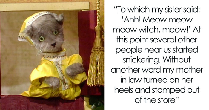
I’m the map, I’m the map, I’m the map, I’m the map. I’m the map!
I remember watching countless episodes of Dora the Explorer as a child, singing the above song and wishing I had a map companion of my own to take me on many journeys. And while I may not be able to provide you with a treasure map to find gold in your backyard, the list we’ve got for all you pandas down below is certainly full of fascinating maps that'll teach you more about the world. Covering everything from religion to politics to the word used for coffee in various countries, these pics pulled from this map-happy subreddit are full of fun facts, with some stunning visuals sprinkled in as well.
Be sure to upvote the maps that you find most fascinating or that you would like to see hanging up on your walls, and let us know in the comments what the best map you’ve ever seen was. Keep reading to also find interviews we were lucky enough to receive from the creator of this subreddit, land surveyor Patrick McGranaghan, and man behind Atlas Altera, Telamon Tabulicus. Then if you’re interested in checking out Bored Panda's last article featuring this fascinating and educational subreddit, look no further than right here.
Click here & follow us for more lists, facts, and stories.
This post may include affiliate links.
This map-obsessed subreddit was created in 2011, and has amassed an astonishing 2 million followers since then. Clearly, there are plenty of people out there interested in maps, so we reached out to its creator, Patrick McGranaghan on Reddit to hear what inspired him to start this extremely successful page in the first place. "The sub was inspired by my love of geography," he told Bored Panda. "I traveled a lot as a kid, and the power of maps was imprinted on me at an early age. I think a lot of people have similar experiences, and that's been the impetus for the growth of the sub."
We also asked Patrick why he thinks people love maps so much. "People love data visualization, and maps are an especially potent form of data visualization," he explained. "I think a lot of the growth of the sub is from Reddit's infrastructure. Reddit can host huge files with high-resolution. You can post huge maps here and zoom in on them and see tiny details. Recently there has been a shift to mobile Reddit. Now people can quickly see and share content and maps can go viral."
We were also curious what types of maps Patrick particularly loves being shared in the group. "There are many kinds of maps that I like, but I especially like pictorial or panoramic maps," he told Bored Panda. He provided links to two of his favorites, including one beautiful depiction of Yosemite National Park in the United States and another brightly colored map of St. Petersburg, Russia, in 1913.
We also asked Patrick if he would be interested in sharing a little bit of what he has learned from running this subreddit. "I've definitely learned a lot about maps from running this sub," he shared. "It has enabled me to meet and connect with map lovers all over the world. On a recent trip to Romania, I got a VIP tour of a map museum in Bucharest because of my social media presence. Running this subreddit has helped me discover peoples and regions that I only had a faint idea about."
Because this map-obsessed subreddit focuses on all sorts of different maps, we thought it would be fascinating to reach out to a map expert who primarily focuses on building a fictional map. We spoke to Telamon Tabulicus, creator of Atlas Altera, to hear a little more about his project and what inspired him to create it. “Atlas Altera is a creative worldbuilding exercise where more than 1000 nations make it onto the world map,” Telamon told Bored Panda. “This work comes from a love of the uniqueness of place and the need to share that love through maps. It is a celebration of geography, history, and languages, as well as all the marvels that lie in us... Us in all our own ways.”
“I started this project because I think we live in an uninspired world, where we've traded in millennia of human complexity and ingenuity for technological idolatry,” he shared. “Technological know-how is great, but it shouldn't replace cultural wisdom and knowledge. Just as we're losing biodiversity, we are losing another layer of what makes our world rich. We're losing cultural diversity too.”
“For me, world maps and place-based descriptions/narratives hold imaginary possibilities that produce real effects,” Telamon told Bored Panda. “The project is a creative attempt at creating a backdrop that can draw people back to a world they took for granted or forsook, and rediscover real wonders and a cultural world worth cherishing.”
Telamon explained that when building this alternate map, his “trick is to pick up plot lines, especially ones that have been abandoned in our history”. “Vile things can and do still happen in the history of Altera, but it's just that each time the winners win, the losers lose less, so that by contemporary times, there is a more diverse and culturally vibrant world... Gone are the days of overt empire-building and erasure, although conflict can obviously still simmer in new ways… I did not create a utopia, but a syntopia, a world where difference is the main defining factor.”
“At the basic level, my project is about meaningful representation,” he explained. “Putting the marginalized, obscured, and erased onto or back onto the map, if only to give more urgency to certain causes or to pinpoint where solidarity needs to take place. You could also say I'm redescribing the world, depicting places in new ways. The intention is not to aggrandize any historical or present nation, nor is it a revanchist stab, but instead, it is to spotlight the cultural diversity that we have inherited in the present, though much of it is no longer clearly visible or has been obfuscated. More importantly, it is about putting to the forefront what we stand to lose in our lifetime.”
Telamon also noted that even the world's languages are reimagined through his maps. "Did you know that only about two or three dozen languages act as the prevailing official languages for the 197 or so countries in our present world? These are languages which, due to a combination of cultural hegemony, economic globalization, and the force and violence of the nation-state, will more than likely crowd out and lead to the downfall of all other adjacent languages. Even other official languages in democracies are not immune. From Ireland to Nigeria to India, the prognosis is bleak. English, as the prevailing and dominant language of business, art and literature, online communication, and bureaucracy, is tracking to win it all—if not within this century, then a couple centuries later.”
“What’s worse, the dominant languages of our contemporary era represent perhaps only a dozen language families, when there are close to two hundred independent language families currently in existence, each one being worlds apart from the next," Telamon went on to explain. "In Altera, the situation is the opposite. Altera boasts more than a thousand distinct prevailing official languages. Every language family (so nearly two hundred) is represented at least once on the map. In doing so, there are more language families and isolates represented in Altera than there are countries in our current world." He also shared a link to a beta version of an interactive map (desktop only) that allows users to explore just which languages actually make it onto the map as "prevailing official languages".
We also asked Telamon what he loves most about maps and where that love came from. “Maps lure people into easy moments of discoveries (because they don't have to get out the door and board a plane or trek into the bush),” he shared. “Sure, you have to have the motivation to take the next step of following-up on something interesting you came across on a map, but a map is an alluring hook nevertheless. I have been obsessed with maps ever since my parents bought me a children's atlas of the world, with fun little drawings and pictures for different parts of the world. I memorized every country on the world map by flipping through atlases like these.”
Telamon shared that he was only 14 when he started creating his own maps. “Oddly, I never really got into fantasy maps. My hobby started with alternate history or historical ‘what if’s. Reflecting on this now, I see that in those days, I was under an unhealthy spell. I thought in terms of states and empires and vainglory. Although alternate history enthusiasts are often interested in the ‘underdogs’ of history, they frequently use the logic of conquest and ‘lost glory’. Most of my early maps were Eurocentric (I'm not even of European descent), and I think partly this was informed by the things I learned in school in Canada.”
“One day, while envisioning on a map a larger and lasting German New Guinea territory, my perspective shifted,” he told Bored Panda. “Here I was trying to surface a viable alternate history scenario in a land where there is this immense cultural diversity, which, unlike where I am in the Pacific Northwest, hasn't even undergone as much erasure as done by states like Canada and the United States. So if I were to dream, why fantasize over more colonialism? More importantly, why dream for more similarity?”
Telamon then went down a rabbit hole researching “amazing but obscure topics in anthropology, ethnobotany, and linguistics”, learning much more about our world, as well as the fantasy worlds many of us immerse ourselves in through books and films. “I realized most of what I was learning about was either hovering or on its way to the past tense. I realized that we live in an uninspired world. Our backdrop has become uninspiring. I feared that soon there would be no more difference to encounter.”
It’s been about a decade since Telamon first started making the maps that would grow into the world of Altera, and although various things pulled his focus away over time, something always brought him back to Atlas Altera. ”During the onset of the pandemic, I tried to wrap up this hobby and take a stab at new interests,” he shared. “I also had a real-life experience of true discovery when I unexpectedly saw the comet Neowise in the night sky on a camping trip in Desolation Sound. This factored into my motivations for printing my maps, but I’m not sure I can articulate why. I tidied up my work and got my main two world maps (the political and chorographical ones) printed to mount on walls. That was an ordeal in itself, but the end result impressed not just myself, but my friends, family, and even the printer and framer. My partner encouraged me to share my project online, and that came to be the beginning of Atlas Altera as a formal project.”
We also asked Telamon why the average person should be interested in maps in the first place. “Maps are about us. They can also be a tool, just as a graph is a tool, to help us envision or visualize relations across space,” he shared. “Maps tell stories. Even just choosing one projection of a map over another can tell a different story or prioritize one story or another. The Mercator map, especially centered on Greenwich, is infamous for how it can prioritize and give extra padding to Europeans,” he noted.
“Why the average person should be interested in my reprojection of the world, however, is because the story I'm trying to tell is something that is hard to piece together when you are living your everyday life,” Telamon explained. “It's hard to access this sort of narrative, this collection of facts, this story of us with this particular set of themes/focus. Here's a quick 5 minute video I made as a teaser/trailer for the project. It's not great, but it helps expand on this idea of ‘reprojection’ that I'm getting at. The political world map of Altera is like a warped projection, one that highlights certain truths over the conventional truths of your average political world map.”
He also added that people often glance at his maps or see them hanging on the wall and don’t even realize they aren’t accurate depictions of the real world. “To me, that's almost a subversive performative act of art, sneaking in fiction into the everyday,” Telamon said. “What this also tells me is that a lot of people are not curious. But the 1/3 of people who do notice a difference or are suspicious enough to look closer, are in for a real treat: genuine moments of ah-has and discoveries or rediscoveries await them as they pore over the details of my map.”
And while Telamon has come a long way in creating Atlas Altera, his work is not finished yet. “With the power of Reddit and other corners of the Internet, I have attracted supporters from all over the world (you can see the supporter wall map at the bottom of the about/preface page), with a decent amount of Patreon supporters for such a niche project,” he shared. “I know that my YouTube videos have even reached people in places like Tidore (Moluccas), where my work was then passed around a West Papuan group chat.” He noted that he also works with collaborators in the Netherlands, France, Italy, Germany, but he’s always looking for even more assistance. “I have had translation help from people in places like India, the Philippines, Thailand, Egypt, Argentina, Brazil, Spain, Mexico, Poland, and Russia, but I am really in need of connecting with Quechuan speakers in Peru. It would be nice to also reach people in West Africa, Ethiopia, and Australian aboriginal communities.”
“Finally, I just want to remind everyone that this is not a roadmap for secessionism, nor is it wholesale advocacy for independence movements," Telamon shared. "Professionally, I do work that facilitates mutual understanding across differences, and I am an advocate for deliberative democracy. All of my work in Atlas Altera is just wishful thinking, because there is a place for that, and it is meaningful, helpful, and even healing to have wishful thinking sometimes.”
If you are looking to check out Atlas Altera or get involved with helping yourself, be sure to check out the project’s website right here.
We hope you're enjoying this list of maps and that you've got some new fun facts up your sleeve that can be whipped out the next time you're in a social setting. It's always fascinating to find out more about our world, especially when information is accompanied by stimulating visuals like the maps on this list. Keep upvoting your favorites, and feel free to let us know in the comments what the best map you've ever seen was. Then if your map-petite still isn't satiated, you can find Bored Panda's last article featuring the same subreddit right here.
You might also like: People share 30 things they did wrong for years before learning the right way


 No fees, cancel anytime


")


 Is Considered To Be The First True Modern Atlas In 20 May 1570")


")


