Get Premium
Dark mode theme is available exclusively for premium users. Learn more about the benefits of subscribing.
No fees, cancel anytime.

 Dark Mode Ad-Free Browsing Unlimited Content
 Ad-Free Browsing Unlimited Content Dark Mode
Join 1.2 million Panda readers who get the best art, memes, and fun stories every week!
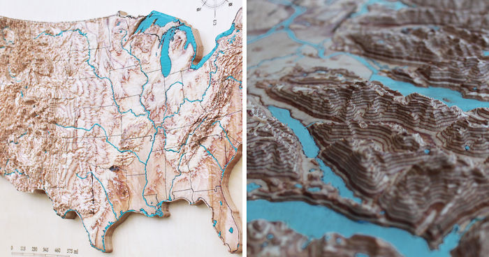
Every 3D map is a surprise in a way, even if you’ve spent your whole life in that location. The elevation dimension reveals the surroundings, opens the crevasses, enlarges the contrast of valleys, reveals the hidden bottom of lakes and the ocean. 3D map is a perfect educational material as well as stunning home or office decoration.
To create a 3D map, I convert the digital satellite data into 3D models and adjust the scale to give an impressive look on wood. Additional vector data is burned with a laser to show shapes of lakes, rivers, borders and in some cases streets, not naming the nominal information that makes these maps fully informative.
I paint water bodies by hand in blue, which makes every map unique.
More info: 3dmapart.com | Instagram
When exploring the captivating world of 3D representations, it’s fascinating to see how detailed spatial visualizations can transcend traditional mapping.
If you’re interested in how 3D designs can bring fictional environments to life with intricate layouts and hidden details, you might appreciate this deep dive into spatial creativity through television settings found inspired by beloved shows.
1Kviews
Share on Facebook
These are Amazing, I would love to see an entire globe of this or at least a very large world map.
You can buy it here: https://3dmapart.com/collections/3d-wooden-maps/products/australia-3d-wood-map
Load More Replies...These are Amazing, I would love to see an entire globe of this or at least a very large world map.
You can buy it here: https://3dmapart.com/collections/3d-wooden-maps/products/australia-3d-wood-map
Load More Replies...


 No fees, cancel anytime


40
5