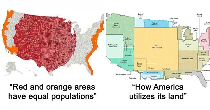
For every Internet commenter who enters online arguments about the USA with facts they got from their butt, there's a map that presents hard data bare and allows the viewers to make their own interpretations.
From light pollution and tree coverage to out-of-service railways and streets and highways, maps may not immediately look as exciting as a viral cat video -- which might explain why we often overlook them when -- but that doesn't mean that are boring. To prove that, we put together a selection of maps that explain the United States better then most textbooks and if broadening your worldview isn't thrilling, I don't know what is.
This post may include affiliate links.
Most Commonly Spoken Language In The Us After English And Spanish
I am not surprised at all. I guess the Amish communities have a great deal in it
Load More Replies...It's a Native American tribe for those that don't know. ;)
Load More Replies...I live in Louisiana. The French here is not the same as European French. It really is a whole different language.
Is that in the same way that american english is different from british english? Different words for items (taps and faucets) and phrases eg This is different from (British) and this is different than (US). I can't come up with better examples off the top of my head, sorry!
Load More Replies...I genuinely learnt a lot from this map, but more so from the comments!
Illinois as an outlier with Polish, I actually think that's pretty interesting
So many Polish bakeries in Chicago - that wasn't a surprise to me though.
Load More Replies...National language of the Philippines. They have many smaller local languages as well.
Load More Replies...TAGALOG: from the Phillipines. "Tagalog (/təˈɡɑːlɒɡ/) (Tagalog pronunciation: [tɐˈɡaːloɡ]) is an Austronesian language spoken as a first language by the ethnic Tagalog people, who make up a quarter of the population of the Philippines and as a second language by the majority."
Doesn't (almost) each island have its own dialect, or separate language? Palawan, Mindanao, Cebu, Leyte, etc...
Load More Replies...Why Arabic in Michigan? Seems like a strange migration point for people of middle eastern decent. That is the strangest one in this entire map!
Henry Ford was well known for liking to hire Arabs. When the car industry was booming, the Arab world was in decline, so a lot of them left and went to Detroit for work. After Detroit took a downturn, less immigrants went to detroit, but Michigan was already established as a hub for Arabs, so they continued to settle in Michigan. The population continued to grow from that, and by them having more kids, so in non Arab nations, Michigan probably has the largest concentration of Arabs in the world.
Load More Replies...I think Indian people prefer England for some reason.
Load More Replies...There’s often overlapping features between maps. For example, a topographic map could be utilized to show the distribution of a local orchid, making it both a topographic and thematic map. It could also be used to show well-known features of specific interest to travelers making this topographic, general reference, and thematic maps all in one.
The most widely used maps are “Political maps”. They are the ones that are usually mounted on the walls of classrooms throughout the world. They show the geographic boundaries between governmental units such as countries, states, and counties. They show roads, cities, and major water features such as oceans, rivers, and lakes.
The United States Of America: Alaskan Perspective
You could put any state in there if it's just going to be based upon the importance to the inhabitants. Or ego. https://www.alaska.org/how-big-is-alaska
This reminds me of a map I saw in New Zealand.... instead of being at bottom corner, New Zealand was at the top middle of the map.... It really makes you think twice about how we view maps.... Why is north up? There is no "up" when you look at the globe from space.
i died laughing and then came back as a Valkyrie to type this (total reference btw.)
Political maps are really good at helping people to understand the geography of the world. They are usually the first type of map that students are introduced to in school, too. They are often called “reference maps” because people refer to them again and again when they have questions.
According to Geology.com, thousands of different political reference maps have been prepared to explain the United States. There are maps of the entire nation, maps for each of the 50 states, and even maps of the 3142 counties (parishes in Louisiana, and boroughs in Alaska) that make up the states. Most counties, boroughs, and parishes are further subdivided into even smaller political units. An incredible number of political maps have been prepared just to display the geography of the United States alone.
How I, A Brit, See The United States (Sorry If It Offends Anyone)
As a Brit myself, I do not see the US in such a way. Well maybe the hot states and Florida is an awful place.
I'm a virgin and I live in West Virginia..... Coincidence I think not 😄
You got the "hot" states wrong. California and Florida aren't all that hot. Arizona, New Mexico and Nevada can be unbearably hot. Louisiana is rather "special."
Agreed. Was looking at houses near Google HQ in CA and almost none of them had air-conditioning. Fireplaces, yes.
Load More Replies...There's a popular joke in Europe that the USA consists of only three parts - New York, Texas and Los Angeles :P
gibbon - you do realise you're just insulting yourself don't you?
Load More Replies...My brother was part of a foreign exchange program back in high school, 1997. We had a German boy live with us in Houston, TX. The first thing he said to us when we got home from the airport was how disappointed he was that he didn't see any horses on the roads.
Patrick McGranaghan, who is a land surveyor in Colorado, USA, and the creator of one of the biggest online cartography communities, r/MapPorn, did an analysis on its most popular posts on Twitter. McGranaghan collected the 10 best-performing posts from the previous 18 months -- about 200 maps in total -- and went through each of them individually, tagging them based on the content, style, and subject matter. He then sorted the tags to see which ones were the most common.
States With A Smaller Population Than Los Angeles County
This is why our voting system is insane. (It was designed for a different view of government, where the states govern the people and the federal government is the government of the states, but now that it doesn't operate at all like that, it doesn't make any sense.)
I would argue that this is why our voting system makes perfect sense. Without the electoral college, the few major cities would be making decisions for the entire country.
Load More Replies...This fact is exactly why we have the electoral college! So that the blue states are not forgotten and their views & votes are heard!!
This is an illustration of the importance of the Electoral College.
This is an illustration of why the EC needs to be abolished.
Load More Replies...LA County has half the population of Australia....the entire country
This why the electoral college is so important, LA county shouldn't have more power than an entire state
So the votes of people living in LA count less then the votes of some other states? How is this fair?
Load More Replies...Yet Los Angeles doesn't get two senators like the rest of the states.
"The most popular subject was history," McGranaghan told Bored Panda. "In this category, the most popular maps were about World War II." Maps about other wars were also well liked, as well as those about the ancient Romans and historic trade routes.
"Another popular category was natural science. Especially popular are maps about wildlife, such as those that use tracking data to show animal migration patterns. Other topics included geology and astronomic maps."
Interestingly, quite a few viral maps focused on language. These include etymology, dialect and various pronunciation maps.
US Watersheds
For those that don't know, a watershed is a geologic area from which all water drains to the ocean. The pink area is the Mississippi river basin which includes the Missouri, Ohio, Platte. Allegheny, Red and Arkansas rivers (among many, many others)
Or when swear words are allowed on the telly! 9pm watershed on UK tv.
Load More Replies...Check one of these maps out in really high resolution (4k+) if you can. It's stunning.
Load More Replies...My hometown of Akron Ohio is right on the dividing line between the Mississippi River Watershed (the pink area) and the Saint Lawrence River Watershed (the forest green area above the pink area). The water in the northern half ends up in the Saint Lawrence River and the water in the southern half ends up in the Mississippi River. It’s a pretty unique situation
I'm from Lima and I never knew this about Akron. I find it fascinating. ヾ(☆▽☆)
Load More Replies...Wow ... the Mississippi River basin is easily half the country from Glacier Park in Montana to the Gulf of Mexico off of Louisiana.
And it spurred my curiosity about how far into Canada the basin extends
Load More Replies...right now I'm at the divide in Minnesota between the bright pink (a Continental Divide) and the light pink
"Another topic that I grouped together are 'political re-alignments'. These are maps that deal with boundaries. Subjects like separatist movements, re-drawing borders, and user-created idealizations. Many of these are satirical and funny," McGranaghan explained.
McGranaghan, however, wouldn't say that all of these maps are scientific. "I think the data is a bit noisy, but it's interesting nonetheless. Users sometimes want a magic formula to make their maps go viral and I don't think there is one. The tastes of the masses are fickle and change over time."
Red And Orange Areas Have Equal Populations
This is not at all surprising, since nearly half the population in this country lives within 30 miles of the coast.
Its surprising to me, an australian, because away from our coastline is void of humans. I wouldve thought the east and west coast would be much higher in pop than the centre
Load More Replies...Why? So that empty land gets a vote? If there is less people there than they should have less voice in the way the country is run. And, I say this as someone living in the grey area. It doesn't make any damn sense to give weighted votes to a smaller population. If that area wasn't almost completely Republicans we would have done away with the electoral college by now. The EC simply exists for the same reason that Republicans gerrymander their districts, so that a loud minority can away elections to their side. I see no argument here for the electoral college other than, "it's not fair more people live where I don't and the majority of the country doesn't agree with me."
Load More Replies...This one is interesting as it is broken down by county rather than state. (For you non-US readers, from largest boundary to smallest in the US- State, County, Township or Parish or City, then sub-division. The last three vary from state to state. Pennsylvania has townships, Louisiana has Parishes, Nebraska has nothing as an example)
Alaska has boroughs instead of counties.
Load More Replies...Ah, San Bernardino County, California, the largest county in America (land-wise). My home, too. -Dr M, Rancho resident
Load More Replies...So we can have a tyranny of the minority? Seems good.
Load More Replies...One may also see where the orange lines end, and the red line ends (mostly on the East), are highland or mountain geographic elevation rises.
When it comes to maps that best describe a country, McGranaghan thinks that it depends on the goal of the mapmaker. "All maps are generalizations, some good, some bad. They are not true representations and a good 'reader' should know that. I think good data visualization will take disparate datasets and find meaningful connections that weren't known before. It sounds simple but it is not so straightforward. A good mapmaker should be familiar with many matrices of knowledge and should be able to sift through them and make new connections."
McGranaghan created r/MapPorn in May 2011 while living in Taiwan, and it currently has over 995K members. He thinks the reason why the community is becoming so big is the same one why people like maps so much: they are easily digestible. So go ahead folks, continue scrolling and enjoy the rest of the post. Bon appétit!
United States Population Lines
The Most Efficient Route Between Every Springfield In The United States
Springfield, Oregon is Mr. G's official Springfield Springfiel...3bf8ac.jpg
Springfield, OR - Matt Goening is from Portland (also, I currently live here and can tell you that there *is* a Moe's Tavern)
Load More Replies...Ya, there's a Springfield in every state, there's no way this is all of them...
Load More Replies...Film theory said the Simpsons lived in Oregon. And there is a Springfield in Oregon! MATT PAT IS A GENIUS!
Tree Cover Map Of The US
No, it's because the Middle of the US is a lot of flat plains and deserts
Load More Replies...I think naturally. The centre of america has been known as the 'great desert' or 'great plains' for centuries before it was split into farming units.
Load More Replies...If I recall correctly, there are more trees in the US than when Europeans began arriving. The land east of the Mississippi River had huge numbers of bison herds, especially in the Ohio River area and south.
Huge swaths of forest have definitely been cleared by European settlers and their descendants, but the continent was NOT coast to coast tree coverage, as some imagine. Much of the glaciated plains were grasslands 600 years ago.
Load More Replies...Trees are awesome. I live minutes away from the Tennessee river and Wheeler wildlife Refuge which is thousands of acres of trees and natural land.
I am in Washington state. We should be a solid blanket of green - except for the fact we produce lumber and it's byproducts for much of the USA as well as China. I am in Grays Harbor County, known for over 100 years (and 'proudly' called "The Lumber Capital of the World") that thus there are now vast harvested areas that it looks like a nuclear bomb went off.
How Much Snow Does It Usually Take To Cancel Schools?
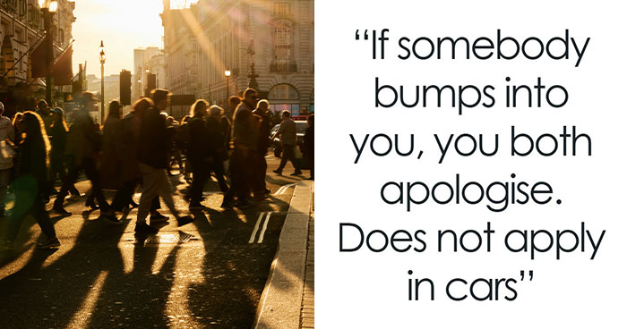
Nice. I always get a kick out of the places that close school for an inch of snow. You don't even need to wear a coat for 1" of snow.
Understand that we (Louisiana) have no way to handle even the smallest amount of snow and ice. Our roads are already c**p, and we have no way to clear them other than wait for the sun to do it.
Load More Replies...The real factor here is the area's ability to deal with snowfall as in equipment and street design. In other words, places that get a ton of snow regularly are ready for it.(Darker blues) The Green states rarely if ever get snow and have road surfaces that have little or no traction and drainage built in.
Absolutely correct, Beazlebug. I am a Yankee who moved to NC, I used to think the state was just full of a bunch of pussies until I figured out all they have to fight ice and snow on there roads was liquid salt and a couple of pick up trucks with flimsy plows attached.
Load More Replies...This is a bit misleading - I live in a 24"+ area and it all depends on if the buses can drive. If the snow is coming down quickly or there is ice involved, we are more likely to close. If the plows can keep up, schools have stayed open when there has been more than 24" of snow...
Good point. 24" of snow over a few days is VASTLY different over night
Load More Replies...The reason that they "cancel" schools in Texas after "just" an inch of snow is because snow usually falls AFTER it has been raining for awhile an when the temps drop, they drop precipitously so that we go from 33 degrees to 12. And we get black ice on bridges and roads. And generally, people from out of state who think that they know "how" to drive on snow always end up skidding off the road because they think that the "bridges" and overpasses are "just" covered with snow, not realizing that there is generally an inch or so of black ice underneath. That's why we cancel school. We are concerned about our children's lives.
I grew up in the northwestern corner of Montana next to Glacier National Park in a small town called Hungry Horse, Montana. I do not remember ever having a "snow day" off from school. EVER!
I found this one funny. I live in the middle of Calif and any snow is a reason to enjoy it.
I grew up in Alaska. School was never cancelled from too much snow. We were sent home early one day because the snow turned into rain after a record snowfall year. School was cancelled twice because of ice fog and a superintendent almost rear ended a school bus.
Nope! Here in the yeehaw state (Texas) it snowed about two years back. Guess what? Everyone went to school. (yes, I live in a part of the yeehaw state that's green on the map) And we had a BLAST.
Most Common Surname In The United States By State
WTF are you talking about? I'm pretty sure that almost nobody could have predicted what the most common surnames are in each state.
Load More Replies...It would be interesting to know why Georgia has "Williams" as their most common surname. The rest kind of make sense.
It's because the Williams family/families are well known as land owners, even back in the UK. More land equals more slaves and more slaves taking the last name of their owner. What a world.
Load More Replies...Martinez means "Martin's son" and García comes from "prince of graceful sight" or something like that
Yes, the es/ez endings are leftovers from the military nomenclature of medieval Iberia, along with the propensity to use both parental surnames, to define one as a Christian, and not Muslim. So, Martinez=son of Martin, Rodriguez=son of Rodrigo (Roderick in English), and so on. When the peninsula was reconquered by the Spanish & Portuguese, the names remained, even if the reason no longer existed. -Dr M
Load More Replies...I find it interesting that the reason that SMITH is the most common surname, is that in the middle ages, people did not have last names. It was John , the gold smith; John the silversmith; John the blacksmith. Anything to do with metal was a "Smith". If the last name was not an occupation, it was a place hame, as in John lived in the town of water, so his name became John Waters. Many names are of occupations no longer needed. John the Copper was the barrelmaker. Name Trivia!
Every State's Least Favorite State
I live in Florida and I approve this message
Load More Replies...We don't hate Pennsylvania though because Eagles, Phillies, Flyers and Freedom! But I am from So. Jersey.
Load More Replies...I think there is a perception among more conservative states that Californians flee their state because it's too expensive, government makes it onerous to do business there, etc., but they bring their liberal politics with them.
Load More Replies...I've lived in Virginia my entire life and had no idea that I hated West Virginia. It's almost heaven for Pete's sake.
People hate their neighboring states because all the people who loved their neighboring states already moved there.
Load More Replies...Alaska doesn't hate Texas. Alaska pities Texas. Poor little former republic.
I thought Alaska hated Texas because Texas always claims to be the biggest.
Load More Replies...As a Texan, I don't know of anyone who feels animosity toward Oklahoma. California has always been the butt of jokes.
I'm from CA and I thought for sure we would be the choice for TX! I think it is, they must have asked the wrong people, lol!
Load More Replies...As a non-American, this one is very hard to read. For one thing, too many items to be trying to cross-reference, but also I don't know all the states by name. North Dakota, South Dakota, Montana... California, Florida, Texas... Alaska and Hawaii... Washington... I feel like I'm doing pretty good to know that many. But where is Kentucky? Wisconsin? You're asking a lot from us! I wonder if they couldn't manage it with some coloured arrows or the like.
Its Very Interesting
We're trying to divide you - Trump couldn't finish the job, so we're proceeding in an orderly fashion. Our apologies, eh.
Load More Replies...Seems like the language spoken map doesn't match what this map is saying. There were no Indian languages on that map, but they are the most common according to this map.
I suspect that is because there are many Indian languages (splitting the demographic) and large reservoirs of german-Americans who have been resident for generations.
Load More Replies...Doesn't correlate with #7 at all. I now imagine all those indian people speaking german...
It does with the Phillipines-Tagalog states...
Load More Replies...Why if so much is India and on the language map so much is German ??
it... most of H1B workers visas go to indians
Load More Replies...Damn. And we were SO CLOSE to getting people to stop confusing Indians and Native Americans.
As a Native Amerindian/First Nations/Indigenous person, I am both offended...and humoured! Thanks for the pun(jab)!
Load More Replies...Presumably it would dominate the whole map and make it quite a dull comparison
Load More Replies...But on the other map it shows that mostly German and Vietnamese are spoken, after English and Spanish?! They can really just made up stuff here and we'll all swallow it
And yet, most of the states with the Indian born residents, have German as the most used language after English.
More People Live Inside The Red Area Than The Grey Area
... and this is the downfall of the American election system called the electoral college.
Actually, I think it's the point of it. So you don't have one unique, densely populated area controlling all the others, with their own distinct needs.
Load More Replies...This shows what a blessing the Electoral College actually is! It prevents cities that can’t even fix their own problems from governing the entire US!!
I don't especially care for the electoral college but if we go to strictly popular vote politicians will work the red areas and let the rest of us go to hell. No, I don't know the solution. Maybe proportion the electoral votes rather than all or nothing. It would require congress to quit showboating and actually do something so we're probably stuck with it.
You do realize that is exactly how the electoral college works right? It is entirely based on proportions.
Load More Replies...This is why the founding fathers established our country as a representative Republic instead of a democracy. They wanted to protect the small states and rural areas from the tyranny of the large states and cities. Do we really want the rest of the country to be ruled by NY and LA?
This shows why having 2 senators per state, and using the electoral college vote instead of a popular vote is grossly unfair in its representation of the actual people in the US. It gives a disproportionate amount of power to low population areas that also happen to lean conservative. That's why the GOP will never fix it.
Please know that the Congress is made up 2 houses for this very reason. The House or Representatives is based on population while the Senate gives equal representation to each state. Different states have different goals, needs, people, landscapes, and industry. It wouldn't be fair to only give a voice to the most densely populated areas. Then everyone else would be underrepresented. As for the electoral college, it's only been different from the popular vote 5 times in presidential elections, and in one of those was (Adams) neither candidate won a majority of electoral votes.
Load More Replies...Yeah, election by popular vote would really be good for the country. Everyone knows how California and New Your know how to run things. ;-)
Texas: state population about 23M. Houston population about 8 M, Dallas the same, San Antonio about 2.5M, Austin about 1M.
Drug Overdose Deaths In The United States Per 100,000 Persons For 1999 And 2014
More like enraging. The deaths from opioids is a direct result of Big Pharma marketing
Load More Replies...This is interesting ... if you overlay this map with the map reflecting population, the rural areas are disproportionately impacted by drug use.
Also, a lot of small towns would be in denial about the amount of drug production, traffic and use. By the time many of them acknowledged the problems, it was already firmly entrenched. There was a LOT of "That can't possibly happen here "
Load More Replies...Worst part is, most of these are prescription drugs. We are the world's biggest giune pigs and we pay the highest drug prices just to be killed by the companies that make so many commercials claiming to care for us. At least 1 commercial per commercial break is for some drug and day time TV is even worse.
Thank the pharmaceutical companies for feeding us all those "non addictive" pain pills.
Hurray for the "War on Drugs"! (btw- I'm sure rates of incarceration would echo this map very closely)
Note that this only shows opioid overdose, which is everything from pills to heroin.
"War on disproportionately BIPOC ignoring the fact that they use drugs at the same rate and sell drugs t a lesser rate.
Load More Replies...I'd factor in technology being the reason for the incline. The internet wasn't at your fingertips back in 1999 like it is today (or was in 2014). Faster means to access dealers.
US States Scaled Proportionally To Population Density
Isn't that wonderful?! I grew up there and boy was it a Great esperience. The only thing we had to worry about were the moose, coming out of the highlands during the winter.
Load More Replies...As a scientist, I can't wrap my head around the concept of making the area proportional to density.
omg... new jersey is huge... i did not expect that, even though i pass like 5 jillion houses everyday and everything... but... WHY IS NEW JERSEY SO FRIGGIN BIGGG
NJ is one of the smallest state, but high population. Lots of tall apartment buildings near NYC.
Load More Replies...The Loudest And Quietest Spots In The Continental US
my house is in the border of very loud and very quiet. I can hear trains, a freeway, coyote howls, and owls hooting.
when you change those coyotes to regular dogs, you just hear what almost everyone in czech republic (without centers of the cities) hears :D
Load More Replies...So THAT'S what the Petshop Boys were singing about! ("GO WEEEEEST! Life is peaceful theeeere" ♬♪)
Well, that is much better than what was stuck in my head. Thanks.
Load More Replies...Out Of Service Railways
for a large country like America, why is there no push for investing on high speed trains to cross the states?
Oh, there was a documentary about it, I don't know the title, sadly. Basically, it's because car companies wanted to sell more cars.
Load More Replies...Fact: in the 1800s when rail was fisrt being laid there was no standard for rail width. Many companies used different widths which means cargo had to be loaded into train A city A, then travel to city B: unloaded from train A to train B and then continue and possible transfer again. Northern states had the benefit if a select few companies while southern states had many different Independant companies. This played a direct role in the logistics of the Civil War. After Vanderbilt created a huge monopoly he standardized the width now used and all other rails were discontinued. All railroads are exactly 4 feet 8.5 inces apart. Why? Because Vanderbilt used the width of a horse carriage which some say has been the same since the Roman times. Additionally, the tracks on the space shuttle mover are the same width. Therefore, Ancient Roman technology has a direct affect on all our lives and to some extent dictated part of space exploration. My dad told me this when I was a kid. My mind is still blown.
Bob, There were plenty of odd gauge rail lines in the early US. Truth is, none of them were other than minor spur lines less than a few miles long that never really connected to anything other than one minor point to another. Why? Because they COST MORE than the standardized equipment of 4 feet 8.5 inches UNLESS you were only buying a very few pieces of rolling stock to be used over a very short distance for specific purpose.
All can be great trails to hike! There actually is an organization called Rails to Trails.
Cost too much per capita of usage, and need for individual conveyance at destinations.
Ask Calif. We've spent millions of $'s and so far we have sporadic bits of railroads. Why? I think it's because it probably costs $100,000 per foot. Maybe that's an exaggeration, but I wouldn't bet on it!
Because it is too long, takes too much time and is uncomfortable. Ride Amtrac from Boston to LA. It's miserable, even if in first class.
The country as a whole isn't set up for rail traffic. For example, when was the last time you saw a car rental office near a train station. When I lived in Phoenix I had to get to Flagstaff (!) to take a train. Airlines have the travel industry down pretty well. You change planes, your checked bags are automatically transferred to the new train. If You want to take a cross-country train trip (and decide to get a compartment for the five-day jaunt), the cost is similar to the cost of going by air (so unless you just want to see the sights, ...). If you want to eat on a train on a long trip you'll find the dining cars sometimes go off with a different train segment when the train is broken up at a major city. The staff is frequently surly. Lots of reasons.
The U.S. Mapped By Residents’ Desire To Move To A Different State
As a Yankee who was raised and still lives in Texas I can tell you Texans are fiercly proud, even the most Democratic liberals. It's not a political thing, it's regional. We are the only state that was it's own country and we are and will ever be the only state by law that us allowed to fly our state flag at the same height as the national flag. Texas also used to stretch almost all the way up to Canada. As a foreigner on vacations, when people ask us what country we're from, we don't say America, we say Texas. I know it's stupid but it's not a red neck thing or political, it's serious state pride. Hell, every eary of Jr. High you have Texas history classes. Three years of Texas History.
In addition to Meyer Weinstock's comments below, Hawaii was also its own country. Per US Flag code, ANY state flag, if flown along side the US flag, flies at the same height.
Load More Replies...So true. Just left Illinois for Wisconsin, and couldn't be happier!
I left Illinois for Wisconsin about 25 years ago. Not going back.
Load More Replies...This poll is from 2013, sure would like to see one for 2020 after all the recent "Blue City Riots" and high taxes.
I can believe this for the year of 2013 but for the year of 2020, California should be the darkest green there is as the majority of us are sick of the c**p that our Governor is pulling! Also because of the high cost of living is ridiculous!
Born and raised (well, still being raised) in Texas, and probably never leaving!
Load More Replies...I want to leave NC only because I am going to be a teacher and it’s not a good state to teach in. Otherwise I would stay here.
We have openings here in CA. -Dr M, retired teacher
Load More Replies...Use Of The Word "Dang" Across The Continental US
So basically the Bible Belt and other religious folk who think 'damn' is a bad word?
Well there is only a 5% difference from blue to red. And how is it in negative numbers? Shouldn't it start at zero?
The scale is number of standard deviations, not percentage :)
Load More Replies...U measures it with the Gi* z-score of (probably) gallup data. You can google "Getis-Ord" for details.
Load More Replies...How America Utilizes Its Land
If Trump has his way the reserves will be taken away from the American Indians to forage for oil. May God save us from him.
Load More Replies...For those of you who didn't get it, they took the numbers for each TYPE of terrain used, and randomly assigned it a block of territory equal to TOTAL SIZE. They are not all squished together like this.
Exactly. With that said, I plan on moving to Maple Syrup town. I love waffles.
Load More Replies...Geez. Some people saw this and thought that the US put all it's housing in the north west, and all animal husbandry in a big square in the middle? Hell of a commute for anyone who works with logging, they put all of it on the other side of the country. Can't even fly or drive there, they put all the highways and airports in Texas!
How ridiculously interesting is that? That kind of thing is so cool to me.
I like how they have designated wildfire zones. How do the wildfires know where to burn?
Percentage Of People Born Outside The U.S. In Each State
Over 25% foreign born in California is significant, especially since undocumented numbers are probably much higher, but hard to trace, since they are... undocumented. No judgement call here I'm not an immigration activist, but 25% is significant, and other areas you see have numbers in the teens as well. I'm sure the natives around Plymouth Rock and Mexico City thought the numbers of Europeans was trifling as well, at first.
Load More Replies...Would like to see a version of this excluding Canadian-born residents. Many Americans don’t even think of us as “foreigners”. We walk among you, completely undetected....
Thanks for pointing this out. Build the Wall 2 is coming soon :-)
Load More Replies...Those immigrants picked your fruits and veggies that you eat everyday. They work in places I can tell you wouldn't have picked to work and they work to feed you for way less wages than any other American would probably get.
Load More Replies...Regions Of The U.S. That Don't Officially Celebrate Christopher Columbus Day
Yes. My company recently decided to rid ourselves of the Columbus day holiday and instead offering a floating holiday we can take at any time during the year.
Load More Replies...Hahaha. Columbus Ohio doesn't acknowledge Columbus Day. I was raised in Columbus, but I remember plenty of Christopher Columbus Celebrations.
Yes they do. My friend lives in Columbus and it's a big holiday.
Load More Replies...Why would anyone celebrate that racist? He didn't achieve anything except for a holocaust in the West Indies.
And the Americas. So many were murdered by him in South America.
Load More Replies...The company I work for started celebrating Juneteenth this year and will most likely trade it for Juneteenth this year.
Good! Far more national significance than Columbus anyway!
Load More Replies...Every state needs to do away with Columbus day. Like the Confederates, horrible people who hate. We need change, to unify.
Popular Coffee Shop Chains By Number Of Locations
F*****g love Caribou. I wish it would come back to PA. I mean I can get some of the drinks at Einstein's, but it's not the same. I miss my Turtle Mocha.
Load More Replies...What?????? You don't know what caribou is???!!! Woah.
Load More Replies...And all three companies serve nothing but flavorless, scalding brown water, or coffee flavored milkshakes.
Expensive flavorless, scalding brown water, or coffee flavored milkshakes.
Load More Replies...Starbucks have an alarming hold over this country. Be afraid! Be very afraid!
Map Of Lowest Recorded Temperature In Each Us State (Fahrenheit)
This is Hilarious to me, my ex-husband was raised in Alaska from 7 year's old until 22 year's old & heard a ton of weather stories 😅 😄 😂 😆 🙃 🤣 😅 😄 I've been there 4 time's but alway's in summer though!
I’ve been to Fairbanks between Christmas and New Years when it was -80
Load More Replies...I belong up north. I loathe the heat and sun. If be happy for overcast rainy summer's and freezing winters.
Trust me, even those of us who grew up in the Midwest and learned to deal with these winters often get sick of the weather after a week or so. It's not just snow; it's hail, sleet, slush, black ice, and the wind--God the wind chill is brutal when it hits your face, and the lake effect snow off the Great Lakes makes you want to stay in your house all day. Sometimes you have to because if you leave your freshly shoveled driveway in the morning, there's a good chance it's fully covered by the time you get home from work.
Load More Replies...The only reason California & Washington are blue is because they have mountains, as do most of the coldest states. N. Dakota & Minnesota get their weather imported from Siberia.
I grew up in a small town just outside of Glacier National Park. I remember having to put antifreeze in the shower drain so it didn't freeze solid. The faucets were always dripping during the winter to prevent freezing. I'm glad I no longer live in that climate.
Forgot this was in farenheit for a sec and wondered how on earth 12 degrees could be the lowest
It is crazy that Arizona is at the same level as Massachusetts
Light Pollution In The United States
Okay, this one makes me curious. I thought the Rocky Mountains would explain the sudden cutoff, but those are more to the west.
So don't tell me aliens can flip themselves across the universe but they can't find civilization enough to talk to someone . . . who isn't in the desert driving a pick up truck and drinking beer!
I can see more from my in-town driveway in Arizona than I could from my parents' house in the country in Michigan.
I can see more from my in-town driveway in Arizona than I could from my parent's house out in the country in Michigan.
Air Traffic Control Zones In The USA
Enroute Center boundaries actually. but Oakland covers nearly the entire pacific ocean.
"Albuquerque Center, Air Force One" "Air Force One go ahead" "Albuquerque, show us now as Special Air Missions 26000." "26000, Albuquerque, roger." Noon, August 9th, 1974.
Scrolling through the maps and I knew what this one was before seeing the heading. I worked ZAU ARTCC.
Those should probably be the states as well. Though I’d hate to have to say I live in Cleveland!
These are en route boundaries. And yes, ZOB (Cleveland center) covers airspace above Detroit. These are buildings, not control towers, where controllers work hundreds of miles of airspace and not just the little airspace around a specific airport like tower controllers.
Load More Replies...i love how like theres literally just CITIES taking over the air control, and not actual states
Um, Air Traffic Control is run by the Federal Government, the Cities are the zones where the main control center and radar stations are based out for each sector
Load More Replies...U.S. Education Spending Map
Explains why so many US citizens show a heartbreaking ignorance and why a guy like Trump could become president.
Funny you should say that, Trump was the winner in two states where education investment is far above average, kind of blows that theory.
Load More Replies...Money spent doesn’t determine quality. NY spends a boatload of $ on education but has some of the worst performing school districts
One of these days we'll get a clue and start valuing our education more than entertainment. I hope......
You have no idea. These are the people we let rule our country! 👍🏻
Load More Replies...This doesn't account for cost of living differentials...NY doesn't have the best public schools in the country it just costs a lot...in fact it isn't even in the top 10...meanwhile Northern WI is largely green but part of that is increased student transportation costs....same with West Texas...Florida meanwhile is in the top 10 for best public education but spends below average.
IHow exactly are you judging your education numbers? A popular way is by SAT scores. FL is ranked 41th out of 48 states. Well below CA at 21. Even Texas which didn’t exactly have scores to yell Yee Haw had much better scores. Texas!! You did beat out West Virginia which is known more for incest than any resemblance of an education system.
Load More Replies...I grew up in one of the red zones. It was terrible. Raising my son in a green zone.
Map Of The United States' 8 Million Miles Of Roads, Streets And Highways
At the beginning of WWI there were about 100 paved miles. After War, future president Eisenhauer was sent on a cross country caravan to determine US ability to defend itself. Revealed a lack of roads, took several months and half the caravan couldn't get across the Mississippi. Ike's observations of the German Autobahn strongly influenced his support and creation of interstate hwy system in 50's.
It would take about 8 years driving 60 to 80 hours a week to drive then all. I think
USA Tree Diversity
In some of these areas, it's actually related to the native species. I can vouch that Arizona doesn't have a lot of tree coverage, especially outside of the mountains, and doesn't have a wide variety of tree species: nevertheless, Arizona has a ton of plant life and diversity.
Load More Replies...Sorry, this is wrong. In my yard, JUST in my yard I have three types of pecan, ten different oaks, five different kinds of elm, mesquite, Chinese pistachio, peach, pear, nectarine, five kinds of plum, five different kinds of pine, three different cedars, cottonwood, three different types of willow, fruited mulberry, bald cypress and more that that. And I only planted ten of them.
imaginw someone whos lived in a dark blue zone moving to northern Florida and just looking around confused like "umm.....that's not an oak?
If you count and put all these maps together.....conclusion is just that Florida is the best state ever lol - you got it all AND good weather
Garbage Can vs. Trash Can In The United States
I was raised that one in the kitchen or left out for collection is a garbage can and the one by my desk that never sees anything damp, oily, or potentially smelly a trash can.
I always thought that the one I put out is the garage can, the one in the kitchen is the trash can, and the one by my desk is the waste basket.
Load More Replies...I grew up with trash can in the house ... garbage can outside the house!
Portion Of Each State That Is Federal Land
Sorry, what's federal land? Why it isn't the same, orproportional, everywhere there? Whose is the rest of land?
Land owned by the Federal government (aka belongs to the country as a whole) as opposed to privately-owned land, which is owned by individual citizens and companies. Federal land includes national parks and the like.
Load More Replies...FYI federal land is usually leased to ranchers for cow ranging, so that giant square in the previous map oveflaps with the blue areas in western US in this one. The inland west has a lot of empty space that's no good for farming, but fine for cows.
Sad that most of the west is owned by the Feds considering by law they are not aloud to own lands other than ports and forts out side of DC.
Alaska and Nevada. That takes a lot of land out of possible state and county tax revenues.
Feds need to turn more of it over to the individual states. We have too much "big government" already.
As a Californian, I say no thank you, I'll keep my national parks instead of more condos and apartments.
Load More Replies...This is now different for Oklahoma with nearly 50% being Indian reservations and therefore federal land.
All U.S. Counties With In-N-Out Burger As Of May 2020
They honestly don't live up to the hype. Their fries are good, but the rest is pretty gross!
Load More Replies...They are a family owned company. They openly state that they will never go public, never franchise, never sell or merge. Any location they build has to be within one days drive of their own meat packing plants. When they decide to expand, they build out their beef packing plants before building the restaurants. If you ever eat at an In-N-Out, look at the inside of the bottom rim of their soda cups, on the back flap of the pouch for their fries. You will find scripture references. This has been continuous for their earliest days. They continue this practice to this day. Very unique operation. They are obsessive about their food being fresh. And…… they will cook anything on their menu to order. That’s why they are famous for their off menu specialties, such as having your burger cooked, “Animal Style.”
When I worked for them, an entire unopened box of patties was one hour (1hr!) past date. The manager had me toss it. That's quality.
Load More Replies...They've crept into Houston. I pray for a swift death. Again, not political. Doesn't matter what side, everyone love Wataburger. About 5 years ago Carl's Jr. Open over 10 stores. Now there's only three left in all of Houston
I gotta have In N Out with chopped peppers. It's the best way to eat it.
Meat, cheese, bacon, bun. Period. Maybe a thin layer of mayo.
Load More Replies...Certainly not enough. But probably all of texas.
Load More Replies...In -N-Out isn't just about the burger, it's one of the few fast food restaurants that goes out of it's way to hire local teens. In So Cal that's a big deal.
A Tastier Map
If you ever want to know how bad a storm or hurricane is, look at the Waffle House index. It's real and FEMA even tracks it.
I live in California. No wonder I've never seen a Waffle House in my life.
Just about every town in GA has Waffle House AND a Huddle House! We like food here in GA.....
WV has a damn sight more that FOUR! Hell, we have two here in Martinsburg
Overlays with the Obesity by Regions Map to a remarkable extent, don’t it?
Would've thought there'd be more in NC. almost like 7eleven up north. One on every corner.
Date Of Creation Of All 3,142 U.S. Counties
Do new cities actually still gets created in THIS century??! Wow.....that's just mindblowin' for Europeans lol
The few blue counties in the eastern states were split off from larger counties in the 1800s as the populations increased.
US Governors By Eye Color
what about people with those cool eyes that change color like my hubby?
Enjoy the randomness and that someone was bored enough to map this.
Voters Who Didn't Vote For Hillary Or Trump
Hoping we can all write in "No one" and take a mental health term.
Load More Replies...If you didn't vote, you don't get to complain... also, if you don't research and vote in your local elections you are doing yourself a great disservice. Local government has a significant impact on your life.
Stille20 would also say that if you voted for the candidate in power, you don't get to complain. Which is just f*****g dumb. You can complain regardless of whether you vote, don't vote, don't vote major party, don't vote for the party that wins, etc. Because that's how rational thinking adults approach problems in the real world. They don't think, 'oh I can't have a problem with anything for the next four years because I voted for the guy in office.' Did Stille go to a government school? Just taking an unscientific poll on the educational history of the predictable slogan repeaters.
Load More Replies...That's "Clinton or Trump". The fact that this headline didn't look odd to you helps to explain why we've never had a female President.
Her official campaign slogan was "Hillary 2016" not "Clinton 2016"
Load More Replies...It's time to stop voting for the "lesser of two evils" and vote for who you feel is right for the country. Don't just vote for this guy or that guy if you don't want them to win. Explore your 3rd option. If we all had the balls to finally vote 3rd party and get away from the big gov that's been shoved down our throat then maybe we would finally see the change!
An artifact of "winner take all" - if you know your state is guaranteed to go to a candidate, you feel your vote matters less and it's less risky to make a statement by voting third party. If we had ranked voting, even more would try 3rd party.
This should be labeled "...voted for someone other than Hillary or Trump." Because on average, about 38% of eligible voters didn't vote at all.
You are only counted as a voter if you vote. Eligible voter and actual voter are two different things.
Load More Replies...Average Size Of US Apartments By Region
I wonder what the map would look like if it was based on rent per square foot.
There should be a map that shows not only the average size but also the average cost. I think most people don't realize just how expensive it is to live in CA. Right now, in the Northern part of the state (San Francisco and up), the average cost for rent is around $2200/month for an apartment that is 900 sqft. Yet the minimum wage is still only $13/hour. Do the math and now you can see why I said that most Californians are trying to leave the state.
Hmm.... yet in many areas of "middle of nowhere" land for sale, there's restrictions of size of building you can build. Many are 900sf+. It's okay to cram families into small apartments, but if you WANT to build something small, you cannot.
Results Of The 1984 United States Presidential Election By County. The Most Lopsided Election In History, The Only State Reagan Failed To Win Was His Opponent’s, Minnesota
In reverse, this must be the outcome of the 2020 election. Trump is setting up the "corrupt election" playbook so that when he loses, he can claim the election was fraudulent. We need to do the same thing Reagan did and OVERWHELMINGLY vote the morbidly obese pathological lying vindictive narcissistic imbecile with the emotional maturity of a toddler (AKA tRump) out of office.
Kevin Donegan are you kidding me? Look at the democratic led cities of this country right now. The American people are tired of it. Your president will be re-elected.
Load More Replies...George Washington unanimously elected by the electoral college receiving support from both major parties of the period.Federalist and anti-federalist. he was the unanimous choice for both terms
Celebrities win elections because of name recognition, not competency.
Ah yes, back when empty rhetoric was enough to get re-elected. oh wait...
US Counties With Gdp Over $100b
um where are the five counties that make up NYC, all five have GDP's over 100B on their own
They are there, if you zoom on the map. Just a hint of red, given that they are geographically tiny compared to the others.
Load More Replies...If California was an independent nation, it would have the fifth largest economy in the world! https://markets.businessinsider.com/news/stocks/california-economy-16-mind-blowing-facts-2019-4-1028142608?op=1
Depends on how you look at it. Your cost of living is sky high too. A typical house there can easily hit $1M. Here in Houston, we make just as much but the average house cost is $275K. Gas is also $1.69 up the street and we have no state income tax. However, property taxes are about 2.5% and sales tax is 8.25%.
Load More Replies...USA Country Map Divided By 1/3rds Of Covid Deaths
The rate of death is 0.3% if you have symptoms. So it's only going down.
Load More Replies...You can thank your joker of a president for being actually the 2nd country in the world to have the highest rate of Covid 19. America is so great that it's second to Brazil rate of deaths and infections of the Covid 19. Congratulations to your joker, he will try to win first place in the race. He says that there should not teste so much for Covid. Hope you'll will go vote him OUT! He is a narcissistic perverted.
He says that if we don't test so much, confermed cases will go down.... Well DUH!! But there will still be a rising in cases....
Load More Replies...this shows who much political fraud has been perpetrated on the American people.
John F: thank you for a CLEAR map where I can read all the information. Most of the maps in this post are blurry and one can't read the sources. Also thank you for the link in the other post.
Load More Replies...In data collected by Johns Hopkins University, the states with the highest per capita rate of COVID-19 are still all in the Eastern U.S. These include New Jersey and Massachusetts, each with above 1,500 cases per 100,000 people. The highest in the country remains New York, which just broke over 2,000 COVID-19 cases per 100,000 people. In most states about 1/2 of deaths from nursing home. Fair question, why is NY the worst state with more deaths than most countries around the world?https://www.statista.com/chart/22110/covid-cases-per-capita-by-state/
population density and public transportation
Load More Replies...Just wait. It’s going to look more like the Waffle House map within 3-4 weeks at the rate things are going.
As an American, I would be really interested in seeing maps like these for the UK and Europe.
Ooooh, id love to see that. You could use adoption data. You could also do one by most spent on vet bills and most food and toys purchased.
Load More Replies...Trump wanted the electoral college defunded because he's against all that fancy edjumacation. His magic 8-ball beats any stupid scientists and their technologeez and advanced mints any day!
Load More Replies...more, please! Ma, Mom, Mama, Momma, Mother etc; Dad, Pop, Papa, Pa, Father, etc; education - and types of education; sleep patterns; loneliness; favorite fairy tales . . .
Most of those were interesting. The political ones, not so much. People's remarks just get rabid.
